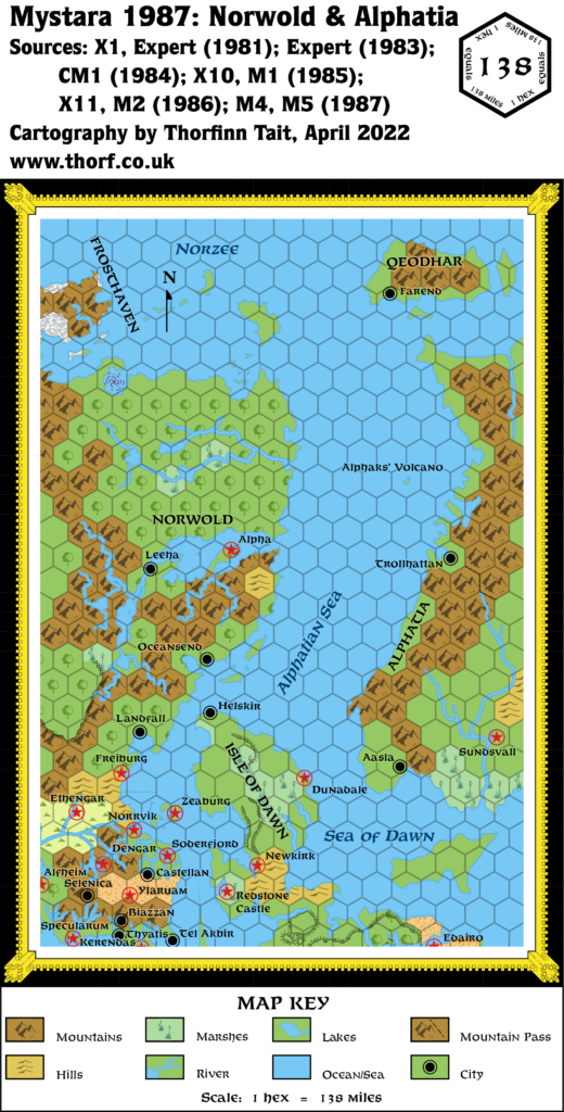
M1 Norwold, 150 miles per hex
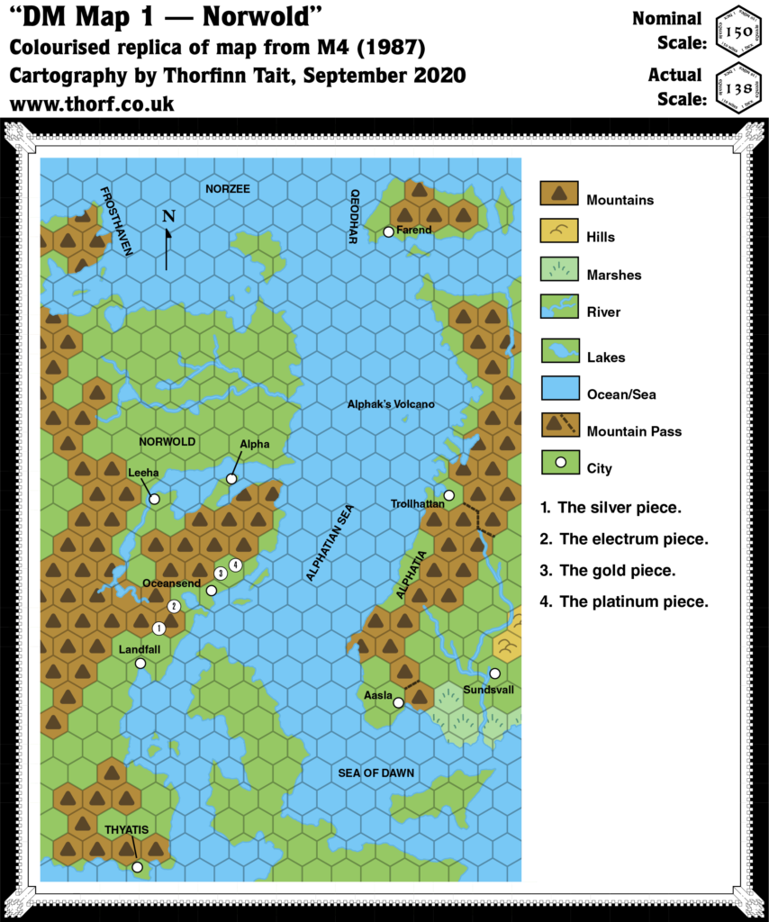
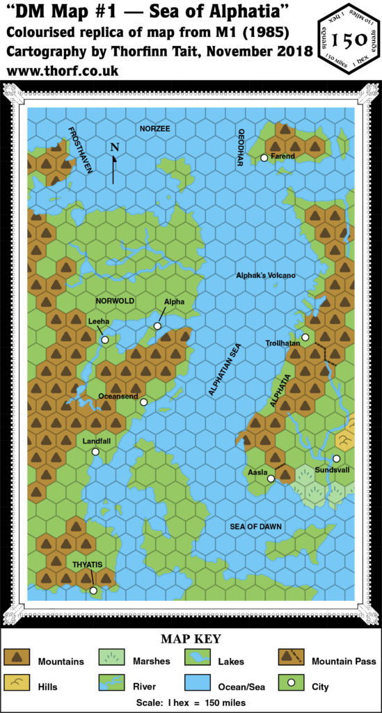
This small scale map of Norwold had a unique scale that would never be used again in published maps. It’s the most zoomed out hex map in Mystara’s history.
Unfortunately, comparison with previous maps of the area indicates that the scale is in fact not 150 miles per hex; instead, a scale of about 138 miles per hex facilitates compatibility with other maps.
The most interesting feature of this map is its portrayal of Alphatia. At this point, Alphatia had only been seen twice before: the extreme western coast in the Companion Set continental map, and the whole island continent in the Master Set world map. This view in M1 shows about half of Alphatia, but in a rather different configuration: the southwestern spur is a separate island, and the northern part has been drastically expanded. Later maps further revised the landmass.
Replica Map (November 2018)
Sources
- M1 Into the Maelstrom (1985) (PDF at DriveThruRPG)
- DM Map #1 — Sea of Alphatia, page 3
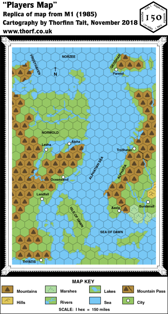
- Players Map, cover gatefold
- Cartography by Dave LaForce
Chronological Analysis
This is Map 34. It was published in October 1985. The updated version of this map has not yet been released. See also Appendix C for annual chronological snapshots of the area. For the full context of this map in Mystara’s publication history, see Let’s Map Mystara 1985.
The following lists are from the Let’s Map Mystara project. Additions are new features, introduced in this map. Revisions are changes to previously-introduced features. Hex Art & Fonts track design elements. Finally, Textual Additions are potential features found in the related text. In most cases, the Atlas adopts these textual additions into updated and chronological maps.
Additions
- Coastline — See Revisions below.
- Islands — Qeodhar and surrounding isles (nameless for now) appear in full for the first time. Alphak’s Volcano is introduced here, too, although its nature means it is only shown on the DM’s map.
- Mountains — Mainland Alphatia’s mountains have been expanded into the newly-appearing areas. Qeodhar gains mountains for the first time.
- Mountain Passes — Two significant passes are featured: one leading from Aasla into the central lands, and another (much longer) leading from Trollhattan.
- Rivers — Alphatia gets new river systems on this map, with a single river in the northwest and a branching system in the south near Sundsvall. The Sundsvall river system previously appeared on the Master Set map, but this map’s version is completely different.
- Scale — This small scale map of Norwold had a unique scale that would never be used again in published maps. It’s the most zoomed out hex map in Mystara’s history. Unfortunately, comparison with previous maps of the area indicates that the scale is in fact not 150 miles per hex; instead, a scale of about 138 miles per hex facilitates compatibility with other maps.
- Seas — The Alphatian Sea, the Sea of Dawn, and the Norzee all appear here for the first time. The borders of these seas are not entirely clear, but based on the context of this map alone, the Norzee appears to be the northern seas around and between Frosthaven, northern Norwold, Qeodhar, and northern Alphatia; the Alphatian Sea appears to be the area between the continent and Alphatia; and the Sea of Dawn the water between the Isle of Dawn and Alphatia.
- Settlements — Farend in Qeodhar, as well as Aasla, Sundsvall, and Trollhattan in Alphatia all appear here for the first time.
- Terrain — Any kind of detail is impossible at this scale, but Alphatia gains a swamp and some hills around Sundsvall.
Revisions
- Coastline— Alphatia has been expanded from the bits and pieces previously seen on the Companion Set continental map, apparently without reference to the Master Set world map, where it appeared in full. The southwestern spur, shown as part of the main island in the Master Set, is now a separate island, and the main island has been expanded greatly to the north, joining up the disparate parts shown on the edge of the Companion map. Unfortunately only the western half of Alphatia is shown, and at this stage there is no way to reconcile the two very different versions. As for the rest, the coastlines match previous versions quite nicely. The eastern tip of the Isle of Dawn, shown for the first time at this scale, appears much as it was shown on the Master Set map.
- Terrain — As noted in Additions above, the scale makes any kind of terrain detail impossible. Consequently, areas previously shown in larger scales (most of the left half of the map) are here drastically simplified into just plains and mountain hexes.
Players Map Revisions
Identical to the DM’s Map in most ways, the Players Map was presented in full colour. The differences are outlined below.
- Islands — Alphaks’ Volcano doesn’t appear on this map as its location is unknown to the players. The Isle of Dawn is labelled here; the DM’s Map left out this label.
- Spelling — Trollhattan from the DM’s map is here spelled “Trollhatan”. Given the real world city of the same name, this is likely an error.
Hex Art & Fonts
- Fonts— Helvetica, except for the “Map Key” title, which is Baskerville.
- New Symbols— Nothing of significance.
Textual Additions (M1 1985)
- Climate — “The southern side of Qeodhar (four hexes) benefits from a rare micro-climate permitted by the proximity of high mountains, a warm ocean stream coming from the east, and a profusion of hot springs. The northern side of Qeodhar is affected by a semi-permanent polar climate.” (p. 7) It should come as no surprise to Mystara fans that Bruce Heard would have included detailed climate notes like this. Happily, the Atlas‘s latest climate map does indeed have a warm current coming up from the south through the Alphatian Sea, which could well have an offshoot running past Qeodhar’s southern coast.
- Dominions — Qeodhar is “a dominion under the fealty of Alphatia” (p. 2). The official title is Barony of Qeodhar (p. 3).
- Government — Alphatia is a strong magiocracy, although the word itself isn’t used yet: “The empire built its power on a solid foundation of magic, with no less than a thousand wizards ruling the empire’s council.” (p. 2) While it’s not explicitly stated, Qeodhar is apparently a feudal dominion of the usual Companion Set style. (p. 2-3)
- Military — M1 contains copious fleet write-ups, which are somewhat outside the scope of this project. Qeodhar is noted to have a “1,000-man militia” (p. 7), in addition to its fleets.
- Nations — Alphatia is noted to be “the oldest empire of the world”, while Thyatis “is much younger”. (p. 2) Old Alphatia is said to be “a distant world” in “another part of this galaxy” (p. 7), strongly suggesting that it’s located on the Prime Plane.
- Planes — Alphaks’ Volcano is said to contain “a two-way vortex to a Plane of Death” (p. 2). Contrast this with Alphaks’ description on the same page, where he is noted to be “a temporal from the sphere of Death”. While this could be interpreted as a mix up between the concepts of plane and sphere, I prefer to think “a Plane of Death” refers to a highly entropic plane. Crucially, it’s not referred to as “the” but rather “a Plane of Death”. Despite the capitalisation, I don’t believe this to be a name but rather a description. On the other hand, p. 28 refers to this place as “the Sphere of Death”, indicating a definite mix up between planes and spheres.
- Rulers — Qeodhar is ruled by Baron Norlan (p. 2), whose full title is Baron of Qeodhar, Kjavik of Norzee (p. 6). King Ericall is still ruler of Norwold (p. 2 etc.). Thincol the Brave is again stated to be emperor of Thyatis (p. 3), having been introduced in CM1 the previous year. There is no mention of Eriadna in M1, even though she was also introduced in CM1, and despite the introduction of her daughter, Princess Mariella (p. 6).
- Settlements — Farend is “the major city of Qeodhar”, while Sundsvall is “the imperial capital of Alphatia” (both p. 5).
- Spelling — “Alphak’s Volcano” was marked on the DM’s Map, but the text names the Immortal “Alphaks” (p. 2 etc.), so this should presumably be “Alphaks’ Volcano” — and indeed DM Maps 4 and 5 both use this spelling (p. 17-18).
Analysis
The version of Alphatia presented here is unfortunately incomplete (western half only), and at odds with the shape published just months earlier in the Master Set world map. The rightmost three columns of hexes have clearly been extrapolated from the edge of previous Brun maps. Interestingly, the southernmost spur has been taken to be a separate island, while the northernmost spur has been connected to the Alphatian mainland. The Master Set world map made the opposite decisions in expanding Alphatia, with the southern spur part of mainland Alphatia on its world map, while everything between Alphatia and the northernmost island (Qeodhar on M1’s map) is completely different.
These two different interpretations are likely the result of simultaneous development of both maps; M1 was probably in development before the Master Set was printed, and the cartographer clearly didn’t get access to the world map. The exact situation and reasons are unknown. Either way, in 1985 terms we are left with a choice between the two versions, with not enough information to decide between them or even to reconcile the two. Later developments are necessary to resolve this.
M1 also presents a quite-detailed account of the remains of Old Alphatia, including a number of maps. However, as with CM6 Where Chaos Reigns (also published in 1985), this lies outside the scope of this project. I will doubtless reproduce these maps at a later date, but since they don’t directly affect Mystara, for now they are low on my list of priorities.
Join in the Discussion at The Piazza
Come and join in the discussion about this map at The Piazza, where I am holding a “read through” of the Let’s Map Mystara project.

