
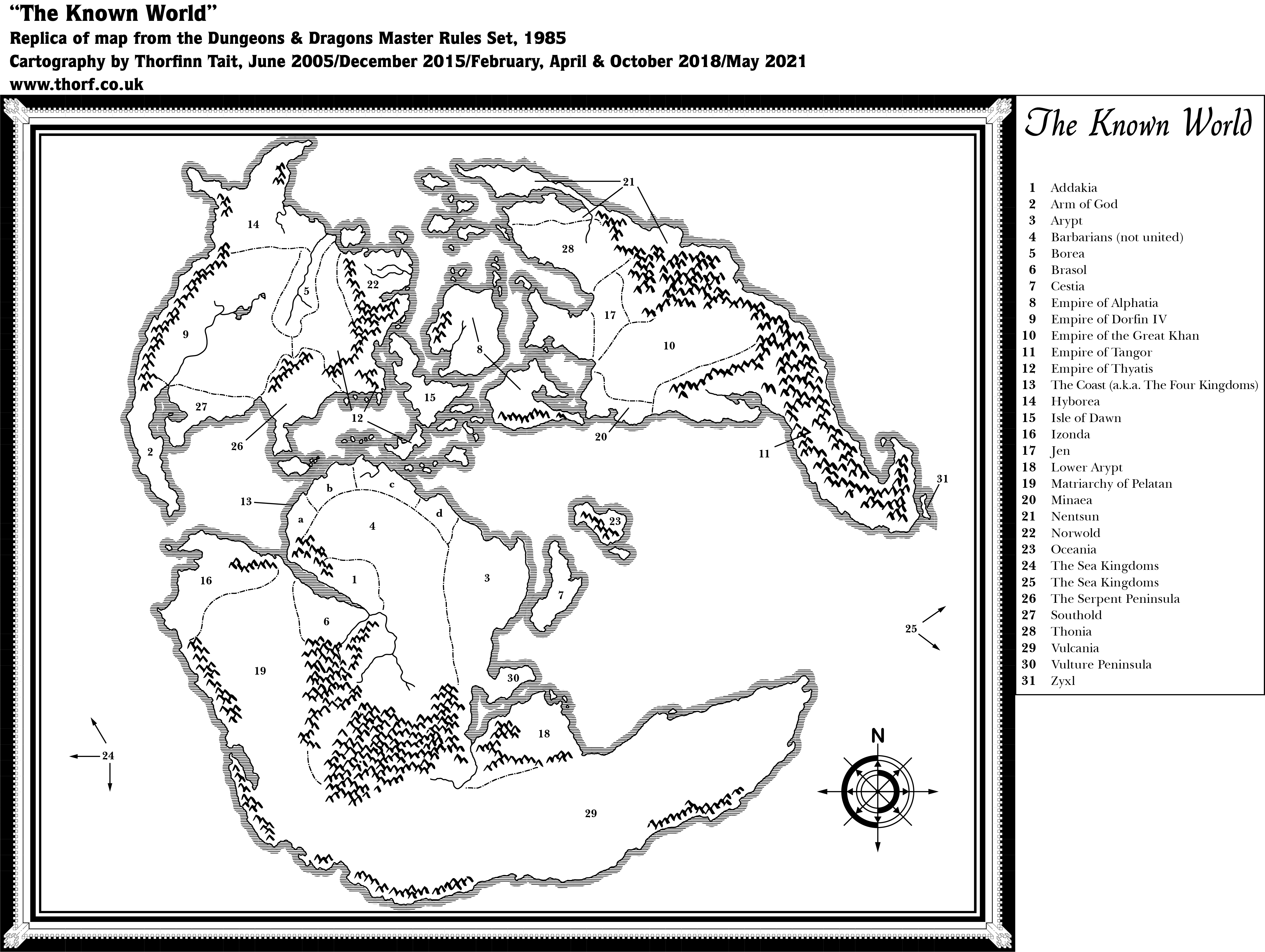
Master Set Outer World
Mystara’s first world map appeared in the DM’s guide of the Master Rules Set (1985). The continent of Brun, along with a small part of Davania, had appeared the previous year in the Companion Rules Set (1984) and CM1 Test of the Warlords (1984).
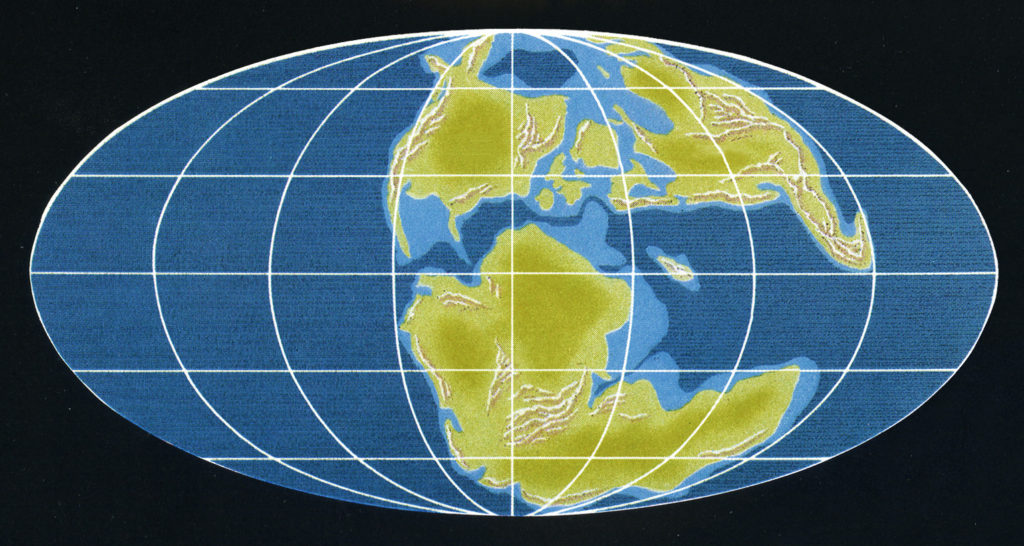
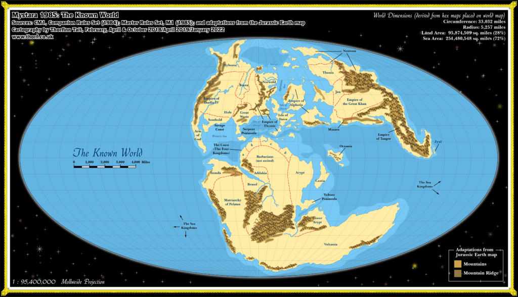
The inspiration for this map is prehistorical maps of ancient Earth — Jurassic Earth, to be precise, around 150 million years ago. The map which this map was probably inspired from was featured in Continents in Collision (1983), a Time Life book in the Planet Earth series. Many fans spotted the similarities back in the 80s, though the map was not posted online until it was unearthed once again in February 2018. For the full story, see this article on thorfmaps.com.
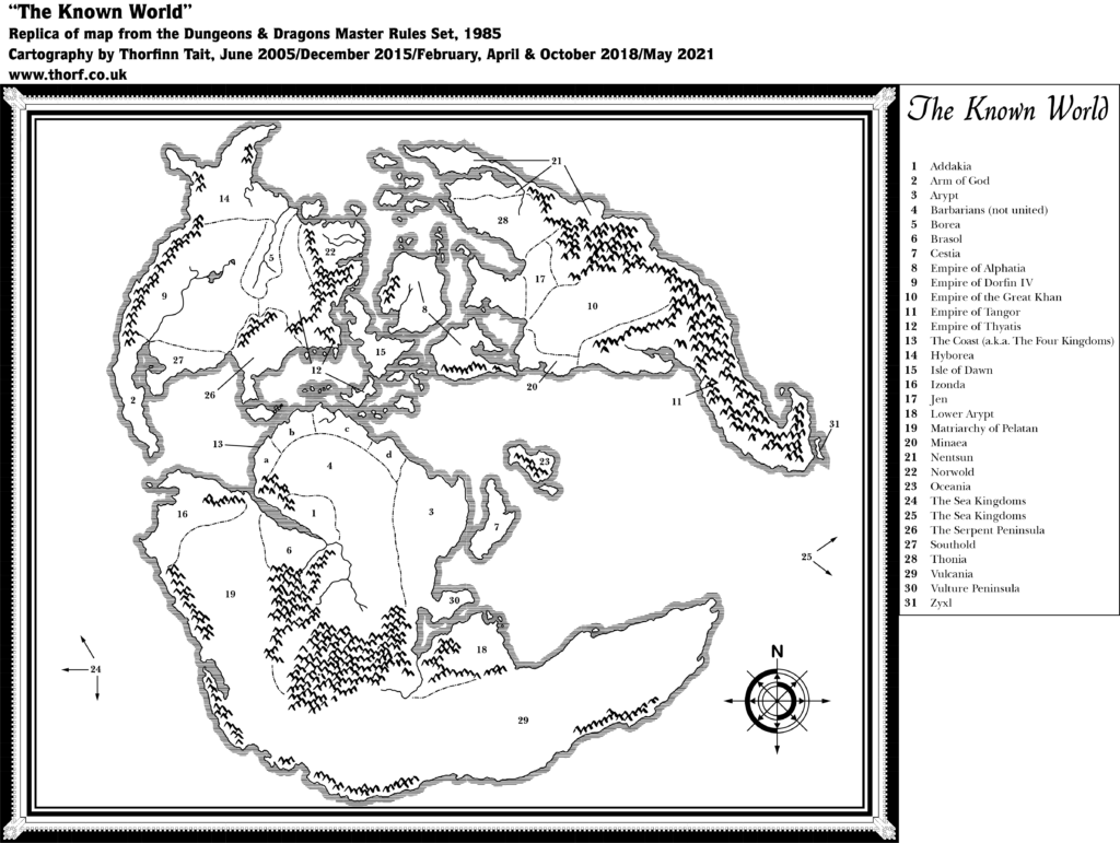
Replica Map (May 2021)
Sources
- Dungeons & Dragons Master Rules Set (1985) (PDF at DriveThruRPG)
- The Known World, non-hex map on the inside cover of the Master DM’s Book
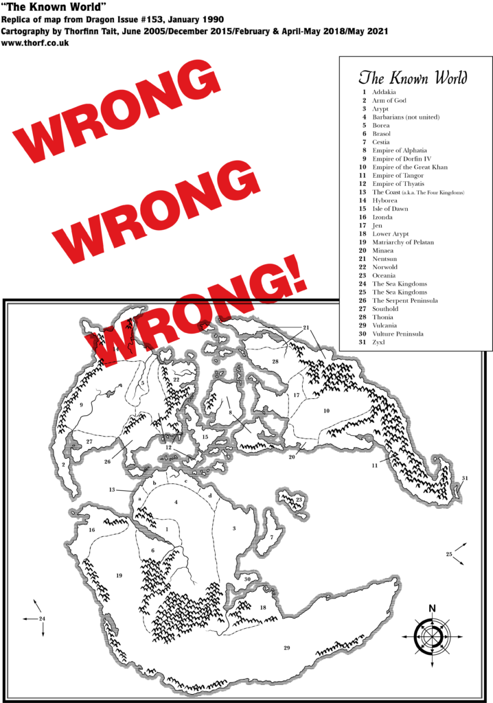
- Dragon Magazine Issue 153 (January 1990)
- The Known World: Wrong, Wrong, Wrong!, non-hex map on page 69
Chronological Analysis
This is Map 32. It was published in June 1985. The updated version of this map has not yet been released. See also Appendix C for annual chronological snapshots of the area. For the full context of this map in Mystara’s publication history, see Let’s Map Mystara 1985.
The following lists are from the Let’s Map Mystara project. Additions are new features, introduced in this map; Revisions are changes to previously-introduced features; Hex Art & Fonts track design elements; and finally Textual Additions are potential features found in the related text. In most cases, the Atlas adopts these textual additions into updated and chronological maps.
Additions
- Coastline — Although still as yet unnamed, Skothar, Bellissaria, and the vast majority of Davania (all but the northern tip) appear here for the first time, as do Brun’s northern and southern extremities. Various small islands between the main continents also appear in their complete form for the first time.
- Continents — With the publication of the world map, it now becomes clear that the world has three major continents, with a number of smaller island-continents in between. However, there are still no names at this stage. So even though I keep referring to Brun, Skothar and Davania, this is merely out of convenience; these names had not yet appeared in 1985.
- Islands — Cestia, Oceania, and Zyxl appear for the first time, with their names in the legend. Various small islands shown on previous maps, including two of what will later become known as the Pearl Islands (between the Isle of Dawn and the southern continent), do not appear on this map. This can be attributed to the scale, as small details are often left out of world maps.
- Mountains — All mountains outside of Brun and western Alphatia appear for the first time on this map.
- Nations — It’s unclear which of the entries in the legend are nations and which are simply geographical names. (See also Regions below.)
- Previously named nations appearing here are: Empire of Alphatia, Empire of Thyatis. Alphatia is applied to the large island marked as such on previous maps, but also to the island to its southeast (later known as Bellissaria). Thyatis had appeared as a bordered area from X1’s map onwards, but here it is shown to cover a much wider area, with three lines indicating the area from mainland Thyatis to northwest of Glantri, and southeast to the large island that will later be named Ochalea.
- Explicit nations added on this map are: Barbarians (not united), Empire of Dorfin IV, Empire of the Great Khan, Empire of Tangor, The Coast (a.k.a. The Four Kingdoms), Matriarchy of Pelatan, and The Sea Kingdoms — the last of which is simply a label pointing to blank sea areas at each side of the map.
- Regions — Isle of Dawn, Norwold, and The Serpent Peninsula we are already familiar with as regional names. The Arm of God and Vulture Peninsula also both seem to explicitly delineate geographical regions. In addition to these, many labels are provided without any indication of their status as either political or geographical areas. The former have been listed above under “Nations”; another three clearly indicate “Islands”; the rest are as follows: Addakia, Arypt, Borea, Brasol, Hyborea, Izonda, Jen, Lower Arypt, Minaea, Nentsun, Southold, Thonia, Vulcania.
- Rivers — Only a few major rivers are marked, all unnamed. Of these, those in Alphatia, northern Skothar, and two in central Davania are new with this map.
- Seas — As with the land, this map provides a complete view of Mystara’s seas. Or rather it would if the map were not clipped to fit the page. (See Analysis below.)
- Terrain — Arm of God, Isle of Dawn, The Serpent Peninsula, and Vulture Peninsula all seem to explicitly delineate geographical regions. In addition to these, many labels are provided without any indication of their status as either political or geographical areas. The former have been listed above under “Nations”; the rest are as follows: Addakia, Arypt, Borea, Brasol, Cestia, Hyborea, Izonda, Jen, Lower Arypt, Minaea, Nentsun, Oceania, Southold, Thonia, Vulcania, Zyxl.
Revisions
- Borders — See above under “Nations”.
- Coastline — Although the coastlines largely match up, the continent of Brun and surrounding islands as shown on previous continental maps have been rotated 2.68º anticlockwise. To fit previous maps onto the world map, this rotation must be taken into account.
Hex Art & Fonts
- Fonts — Quill (map title), Baskerville (everything else).
- New Symbols — Art is in the same style as 1984’s continental maps.
Textual Additions (Master Set 1985)
- Planes — the dragon rulers are said to have home planes in the Outer Planes. It’s unclear from the text whether this is one plane for all four, or four separate planes: “If a dragon ruler’s material body is slain, the spirit goes to its home plane (one of the Outer Planes) and creates a new body.” (DM p. 29)
There is surprisingly little setting information in the Master Set, despite its inclusion of the world map. Indeed, the key to the world map provides the only new information, but with no associated text or explanation of any kind. So we are left wondering about all of the tantalising, mysterious names in the map’s key: what kind of land is Vulcania? Who is the Great Khan, and what is his empire like? What do the people of Zyxl have against vowels? And just who is this Dorfin fellow?
This is the first map to use the name “Known World“, and perhaps even the first Mystara product to do so. (1984’s XSOLO used the phrase uncapitalised in its text.) Here, it clearly refers to the entire world, and presumably it’s from this point on that the world itself began to be referred to by that name.
Years later, in 2006, Frank Mentzer answered some questions about the origins of the names on this map. Let’s take a look at what he said. Some comments are in response to a list of suppositions posted by Travis H, which Frank responded positively to. Only Frank’s comments are included here, but it’s worth looking at Travis’s list, too.
- Cestia — “Derives from the Greek rather than the Latin, and is another matriarchy.” The reference is to Greek cestus, which according to Wiktionary is “A girdle, especially that of Aphrodite (or Venus) which gave the wearer the power to excite love”
- Dorfin — “A tangent reference to Amber.” Presumably refers to The Chronicles of Amber by Roger Zelazny.
- Izonda — “From whole cloth.” Seems to mean it’s just made up.
- Jen — “? Doesn’t ring a bell… are you sure this one’s mine? No notable mythico-historical referent in any event.”
- Minaea — “Sea traders & specialists in bronze, famed for the Labyrinth; Minoa (q.v.); destined to fall because of the rise of iron & steel worldwide”
- Nentsun — “nent (arch., about/towards) [the] -sun, ie land of eternal sun”
- Pelatan — “No idea, but it sounds French… probably something from Francois and/or Bruce Heard.”
- Tangor — “Tip o’ the hat to Burroughs again… do your homework. ;> ” Refers to an Edgar Rice Burroughs novella, Tangor Returns.
- Real world sources — “Some are obvious and derivative… Hyborea, Arypt (Egypt), Brasol (Brazil), Hyborea and the related Borea, Oceania of many legends, Northworld (Norwold) and the corresponding Southold, and the Empire of the Khans (corresponding to the empires of central Asia). Some were completely fantastic but undetailed, while some are mentioned in my preplanning notes (like the Arm of God and Zyxl) but were never completed.”
- Robert E. Howard influence — “There’s a lot of REH influence throughout.”
- Thonia — “Rather than from Blackmoor, is more easily searched if you put a “C” on the front. … Try http://en.wikipedia.org/wiki/Chthonic.” It refers to the Underworld.
- Thyatis — “Grandfathered, the name invented by either Zeb or Tom M.” We now know this to be Tom Moldvay and Lawrence Schick.
- Vulture Peninsula — “Note the plethora of unusual life forms in historical Madacascar.”
Join in the Discussion at The Piazza
Come and join in the discussion about this map at The Piazza, where I am holding a “read through” of the Let’s Map Mystara project.
Past and Future Versions of this Map
This article was originally published 5th February 2018.


Jurassic Earth as Mystara – Thorfinn Tait Cartography
5 February 2018 @ 9:01 pm
[…] and you will see that all of the major land masses are there, and they are largely the same as Mystara’s world map, which was provided in the Master Rules Set. There are a number of minor differences, but the […]
Lining Up Mystara Revisited II – Thorfinn Tait Cartography
20 February 2018 @ 12:01 am
[…] upon, Jurassic Mystara will need to be georegistered. This means matching up the coastlines of the Master Set world map — or indeed my 2016 model — to the Jurassic Earth map as closely as possible. With the […]
Lining Up Mystara Revisited IV – Thorfinn Tait Cartography
1 March 2018 @ 9:23 pm
[…] the same time, the consensus was that the 2.2º rotation of Brun to match CM1’s map with the Master Set outlines is a step too far, making life difficult for cartographers for minimal gain in […]
Let’s Map Mystara! – Thorfinn Tait Cartography
13 April 2018 @ 11:33 am
[…] about this for an idea… Writing the commentary for all these old maps I’ve been re-releasing lately has crystallised something I’ve been wanting to do […]
Dawn of the Emperors Alphatia, 24 miles per hex – Atlas of Mystara
27 April 2018 @ 11:30 am
[…] detailed map released for the island continent of Alphatia. It was previously visible in the Master Rules Set world map, as well as various continental maps of Brun, but the Dawn of the Emperors version was rather […]