, 8 miles per hex")
Thyatis, 8 miles per hex
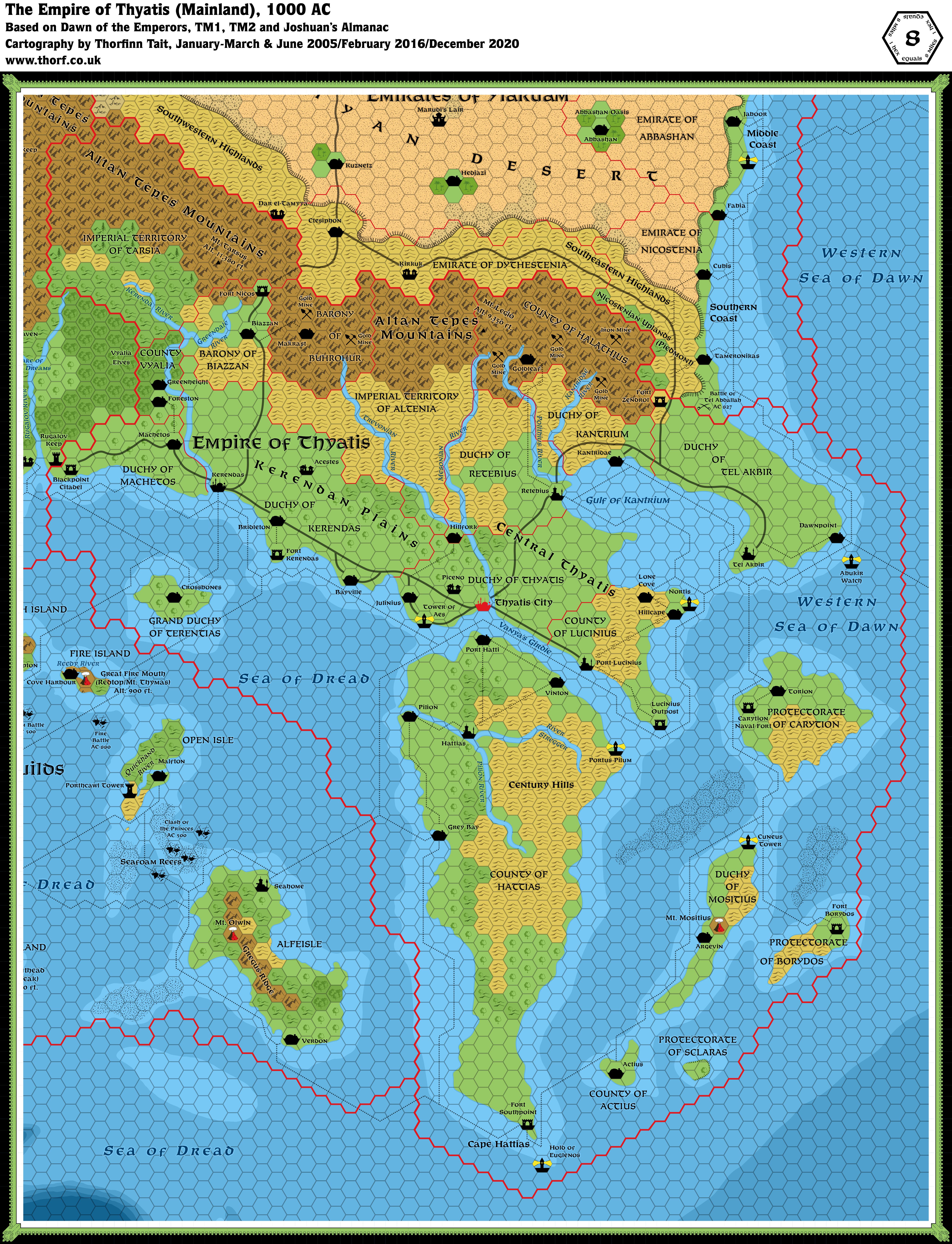
The nation of Thyatis is made up of the southeast corner of the western continent and several nearby islands. North are the Altan Tepes mountains, which protect Thyatis from desert winds and raids by the Ylari warriors. West is the thick Dymrak Forest, haven of elves and goblins. South and east is the sea — a shield from foreign ground-troops but a road for Thyatian vessels.
from Dawn of the Emperors Book Two, by Aaron Allston
Map (December 2020)
Sources
- Dawn of the Emperors (1989) (PDF at DriveThruRPG)
- TM1 The Western Countries (1989)
- TM2 The Eastern Countries (1989) (PDF at DriveThruRPG)
- Rules Cyclopedia (1991) (PDF at DriveThruRPG)
- Karameikos: Kingdom of Adventure (1994) (PDF at DriveThruRPG)
- Joshuan’s Almanac (1995) (PDF at DriveThruRPG)
Comments
The hills in the western Imperial Territories have been changed to mostly forested hills, in line with the changes to Karameikos. Their proximity to tree-loving Vyalia also suggests that they would most likely still be forested.
I also redrew some of the dominion borders to follow the rivers where they were doing so anyway. Rivers tend to form natural borders, and there is no need to conform strictly to the hex grid when these are available.
Notes
- Acestes — on Joshuan’s Almanac page 222a, Klarmont 15 entry, the text says: “Triumphant, a young stallion owned by Priam Iphisius of Acestes Village, wins the Kerendan Derby by 10 lengths (at 30 to 1 odds). Priam refuses an offer of 100,000 gp for the horse.” As per Simone Neri’s suggestion, the Atlas places Acestes in Kerendas.
- Altan Tepes Mountains — the word “Mountains” was dropped from the label on TM2.
- Battle of Tel Abdallah, AC 827 — the Dawn of the Emperors Thyatis map adds this label to the Thyatis-Ylaruam border, albeit without a battlefield symbol. The symbol itself was added in TM2. However, the label was also changed, and now reads “Battle of Tel Abddallah”. The change was carried over into the Rules Cyclopedia, but it seems likely to be an error. The Atlas considers the original “Tel Abdallah” spelling correct.
- Bayville road — Bayville in the Duchy of Kerendas is the only mainland town not connected to the road network. This seems like an oversight, so a coastal road has been added, leading from the main Kerendas-Thyatis road to Bayville, then back to the main road.
- Blackpoint Citadel — “…the fort of Blackpoint Citadel … sits opposite from Karameikos’ Rugalov Keep.” (Dawn of the Emperors DM’s Sourcebook page 14c) Blackpoint has a label on the map, but the symbol next to it is Rugalov Keep across the border. While it’s possible that the two keeps are in the same 8 mile hex, this makes the map unnecessarily complicated. Therefore the Atlas marks Blackpoint in the hex south east of Rugalov Keep, where the road meets it on the Thyatian side of the border. The population of 1,250 dictates the use of a fort symbol.
- Borydos Island — Dawn of the Emperors Player’s Guide to Thyatis page 7a: “…a rocky, hilly island…” The terrain has been adjusted to reflect this.
- Case Discrepancy — while most settlements on the Dawn of the Emperors map were listed in Title Case, the following were displayed in capitals: CUBIA, TAMERONIKAS, TORION. These have been standardised to Title Case for the Atlas.
- Central Thyatis — generic as it is, this name is used in Title Case in Dawn of the Emperors‘ Player’s Guide to Thyatis (page 6b).
- Century Hills — the hills of central Hattias, which had no name marked in Dawn of the Emperors, are named the Century Hills on TM2.
- Coastal Waters — Dawn of the Emperors didn’t show shallow and deep water on any of its maps. TM2 showed coastal waters for the first time for Thyatis.
- Cubis — this Emirates town was incorrectly labelled Cubia on the Dawn of the Emperors poster map. The error originated on GAZ2’s map, and was repeated on TM2.
- Fort Nicos — TM2 spells this “Fort Nikos”. However, the Dawn of the Emperors Thyatis map, and the DM’s Sourcebook (page 8a-b) both use “Fort Nicos”. The Atlas accepts the original spelling as the correct one.
- Greendale River — this tributary of the Kerenda River was renamed to Grendale River on TM2, and this was then repeated in the Rules Cyclopedia. Located close to Greenheight, it seems reasonable to accept the original Greendale spelling.
- Grey Bay — while Dawn of the Emperors labelled this Hattian town “Grey Bay” using the British English spelling, TM2 changed it to the American English spelling “Gray Bay”. The Atlas uses British spellings throughout, and therefore keeps the original Grey Bay.
- Imperial Territories — the bracketed “and future dominions” which appeared on Dawn of the Emperors‘ map was removed from the label for TM2. The Atlas adopts fan suggestions to name these regions, with the western region named Tarsia after Mount Tarsus, and the central area called Altenia after the Altan Tepe Mountains. Both retain their Imperial Territory designations, leaving the contents of these regions open.
- Kantridae — added a short road to connect with the nearby main road; the shape of the hills likely explains why it’s not on the main road.
- Kantridae and Kerenda Rivers — the Dawn of the Emperors map has “Kantridae River” and “Kerenda River”, while TM2 and later the Rules Cyclopedia both use the inverted forms “River Kantridae” and “River Kerenda”. Presumably both versions are extant uses of the names, probably used interchangeably. The Atlas adopts the Mystaran standard of placing “River” after the name.
- Kerendan Plains — “The western region of mainland Thyatis is called the Kerendan Plains.” (Dawn of the Emperors Player’s Guide to Thyatis, page 6a) The description goes on to mention three main communities: Foreston, Greenheight, and Kerendas itself. It seems therefore that the Kerendan Plains stretch from Vyalia and Machetos in the west to the eastern limits of Kerendas.
- Kerendas — with its population of 100,000 (Dawn of the Emperors DM’s Sourcebook page 14b), Kerendas is a metropolis. Its symbol has been changed accordingly.
- Kerendas Outpost — Bruce Heard pointed out that this is likely a fort rather than an outpost. It has therefore been renamed to Fort Kerendas on the updated map.
- Lighthouses — TM2 added six lighthouses around the coast of Thyatis: Abukir Watch, Cuneus Tower, the Hold of Euglenos, Nortis, Portus Pilum, and the Tower of Aes.
- Makrast — this dwarven town is marked as Markrast on TM2 and the Rules Cyclopedia maps. Dawn of the Emperors has it as Makrast both on the poster map and in the text (DM’s Sourcebook page 8c), where it is listed as “Makrast (Broken Mountain)”. Moreover, GAZ6’s Dwarven Language Glossary (pages 28-29) includes both “mak” (meaning broken) and “rast” (meaning mountain). Both books were written by Aaron Allston, so it seems very likely that Markrast is a mistake. This Atlas uses the original Makrast.
- Mesonian River — Dawn of the Emperors’ Player’s Guide to Thyatis (page 6b) spells this “Mesonion”. However, the poster map has Mesonian, and this spelling was used on TM2 and in the Rules Cyclopedia. In the absence of further references, the Atlas has gone with the map’s Mesonian spelling.
- Mines — Dawn of the Emperors DM’s Sourcebook (page 9b) mentions County Halathius’ famous gold mines, and also its productive iron mines. The updated map marks three gold mines and an iron mine to represent this. Page 8c also mentions gold mining in the dwarven Barony of Buhrohur. Two gold mines have been added here, too.
- Mountain names — TM2 marked two new named mountains in Thyatis: Mt. Tarsus, Alt. 11,380 ft., and Mt. Legio, Alt. 935 ft.. However, Mt. Legio’s altitude is surely a mistake. The updated map amends it to Alt. 9,350 ft.. Thanks to Fabrizio Paoli for spotting this.
- Mount Mositius — “A famous adventuress … investigated Mount Mositius and discovered the truth: The volcano was long dead…” (Dawn of the Emperors DM’s Sourcebook page 15). Mount Mositius was not marked on the poster map, but appeared on the map for the first time on TM2.
- Piceno — Poor Wizard’s Almanac III page 157 mentions this village in Central Thyatis. Slaves from the slave revolt some days prior were found in this village, so it has been placed in the direction of Karameikos, off the main road.
- Sclaras Cliffs — “Sclaras is an inaccessible island — it is a rolling, deeply forested land sitting atop cliffs, cliffs which face the sea at every point.” (Dawn of the Emperors DM’s Sourcebook page 22a).
- Stegger River — this river was changed to the River Stregger on TM2, and the same caption then appeared in the Rules Cyclopedia too. The updated map uses Stregger for now.
- Thyatis City — the capital, called Thyatis City on Dawn of the Emperors‘ poster map, was relabelled “City of Thyatis” on TM2, and this change was repeated in the Rules Cyclopedia. It seems a trivial change, and both names are likely in use — as well as the name “Thyatis” on its own.
- Trade Routes — page 22b-c of the Dawn of the Emperors DM’s Sourcebook provides some amendments to trade routes: “First, the island of Terentias is on the Vorloi-to-Kerendas stretch; most ships hug the northern coast, while many jump down from Rugalov to Terentias and then up to Kerendas. Also, the Minrothad-to-Gapton route continues on to Terentias and then to Kerendas.” I have therefore added a route from just off Rugalov down to Crossroads on Terentias; another from Crossroads up to Kerendas; and another coming from Gapton up round Terentias to Crossroads.
- Trevonian River — TM2 changed this river from the Dawn of the Emperors poster map’s Trevanion River; the A and the O were inverted. This change puts it in line with the nearby Mesonian River, therefore the Atlas accepts TM2’s version as most correct. The Rules Cyclopedia repeated the changed caption, Trevonian.
- Villages — no villages were marked on Dawn of the Emperors‘ poster map. This is perhaps an indication of the population density, but it would be good to add some villages.
- Ylaruam — the sections of Ylaruam appearing on the Dawn of the Emperors Thyatis map are largely undeveloped. The plateaus and other details do not appear, and the terrain is radically different from GAZ2’s map. Clearly it should be ignored.
References
- Thyatis at the Vaults of Pandius
- Thyatis map thread at The Piazza
- Battle of Tel Abdallah, AC 827 — discussion thread at the Piazza.
- Mapping Issues: Towers, Keeps, Forts and Castles at The Piazza
- Proposed location of Piceno — post on Facebook. Also see a comment on one of the shared posts for Kantridae roads.
Thanks to:
Andrea Barbiero, Bruce Heard, Simone Neri (Zendrolion), Fabrizio Paoli (‘Brizio), Andrew Theisen (Cthulhudrew)


19 January 2016 @ 3:37 am
Hi Thorf, Mt. Legio (935 ft. / 285 m) doesn’t really look like a mountain.
Although tallest than the highest point in Denmark, I doubt the Thyatians would ever call it “mountain”.
Can we exclude that someone forgot a zero at the end?
19 January 2016 @ 9:39 pm
You’re quite right! It also looks to me like most mountain altitudes end with a “0” on Mystaran maps, which doubly singles this one out as an error.
I’ll change it to 9,350 ft.
9 February 2016 @ 8:14 pm
Hi Thorf, great updates on the map! Just a couple of comments:
1) Is there any particular reason behind your choice of “Tarthia” over “Tarsia” as the name of the western Imperial Territories? I’m asking because “Tarthia” seems to be an odd tweak of the original name of Mt. Tarsus… (moreover, it also looks quite like “Thrathia”, which should be the name of the Thyatian Hinterlands).
2) What about adding the village of Piceno from PWA3? Here is the reference (I copied and pasted it from my own post on The Piazza):
* Village of Piceno (from Poor Wizard’s Almanac III)
Nuwmont 20 entry, event “Slaves Unleash Terror”, is set in a farmhouse “near the village of Piceno”, located in “Central Thyatis”.
The village is not located in the Kantrium area, as I previously thought, but in the region called “Central Thyatis” (domains of Thyatis, Lucinius, and Retebius). Since the village is tied to the Ac 1012 events regarding the slave uprising in Thyatis City, I suppose Piceno’s best location would be somewhere in the vicinities of the capital.
Source: “Poor Wizard’s Almanac & Book of Facts III, AC 1012” by Ann Dupuis (TSR 2506, 1994), page 157.
9 February 2016 @ 10:22 pm
Hi Simone!
1) This is just bad memory on my part. I thought you had suggested Tarthia. I was probably conflating it with Tarthis. I’ll change it to Tarsia.
2) Done! I’ll post on Facebook to check the location with you.
3) I’m still in the process of working through official population figures. Thanks for spotting these, and please let me know if any more need changed!
9 February 2016 @ 8:44 pm
Oh, another thing: the symbol of Kerendas is to be changed to “metropolis” (black “capital” symbol) then?
5 January 2019 @ 12:14 pm
Why are some rivers “X River” and others “River Y”? Karameikos seemed to establish a pattern of Thyatians preferring the former format.
21 March 2019 @ 6:43 pm
That’s a very perceptive observation, but isn’t this a matter of style more than anything else?
… … …
I looked into this and discovered that the position of the word “River” may be a regional thing. It looks like the British English convention is “River X”, while in the US it’s usually “X River”. I had never realised this difference.
So, looking at things from a real world perspective, the Traladaran names were created by British authors (in B10) while the Thyatian names were created by an American, Aaron Allston (in GAZ1).
Dawn of the Emperors, also by Aaron Allston, had all rivers as “X River”. TM2 revised some but not all of these rivers to “River X”; of these, the only one I adopted in this map was “River Stregger”, but this was more due to the different spelling (Stegger became Stregger) than the position of the word “River”. Incidentally, I believe that Bruce Heard (who is French/American) drafted TM2.
So, the conclusion is that the variant river naming comes from TM2. From an in-world perspective, perhaps we could conclude that the Thyatians are happy with either order. I guess I could revert the order on this map to Stregger River just to be consistent.