Darokin Provinces
A recreation of the Wizards of the Coast Mystara Message Board thread, with restored links and images.

01-30-06, 04:06 PM
|
 |
Member
|
|
Join Date: Jan 2005
Location: Akita, Japan
|
|
 Darokin Provinces
Last summer, Giovanni Paniccia brought to my attention page 11 of GAZ11, which includes a map of the provinces of Darokin. The map is black and white, 24 mi per hex scale, and does not have any names for the provinces. It does however divide them into heartland and borderland.
I have finally gotten round to updating my map, which I present below. It replaces the Darokin map that I made last year.
It occurs to me that it might not be too hard for us to think up some names for each of the provinces on the map. So if anyone wants to have a go, please be my guest.  |
01-30-06, 04:07 PM
|
|
Member
|
|
Join Date: Jan 2005
Location: Akita, Japan
|
|
The Map
 The Republic of Darokin, 8 miles per hex, January 2006
[The original map posted here has been lost. This is a reconstructed version created from an old Illustrator file and Hugin's map from later in the thread. Thorf, February 2021]
The Republic of Darokin, 8 miles per hex, January 2006
[The original map posted here has been lost. This is a reconstructed version created from an old Illustrator file and Hugin's map from later in the thread. Thorf, February 2021] |
01-30-06, 04:25 PM
|
|
Member
|
|
Join Date: Jan 2005
Location: Akita, Japan
|
|
Darn...
I'm having problems with my FTP program, so the map has not been updated from the old one yet. 
Does anyone know of a good (free) FTP client? I have always used WS
FTP, an ancient old version, but I just can't get it to work today at
all. 
Edit: Never mind, I got Smart FTP and the image should now be updated.
Last edited by Thorf : 01-30-06 at 04:32 PM.
|
01-30-06, 05:06 PM
|
|
Member
|
|
Join Date: Mar 2001
Location: Italy
|
|
Quote:
|
Originally Posted by Thorf
It
occurs to me that it might not be too hard for us to think up some
names for each of the provinces on the map. So if anyone wants to have
a go, please be my guest. |
Of course, the provinces including large cities may be named by the city itself.
The provinces of central Darokin could be named Ansimont (cap. Ansimont) and Eastwind (cap. Wrasseldown). |
01-30-06, 05:29 PM
|
 |
Member
|
|
Join Date: Dec 2005
Location: I remember there was mist...
|
|
The text on the map says the borders come from GAZ10 Orcs of thar. Surely that's a mistake?
|
01-30-06, 05:57 PM
|
|
Member
|
|
Join Date: Jan 2005
Location: Akita, Japan
|
|
Quote:
|
Originally Posted by Rhialto
The text on the map says the borders come from GAZ10 Orcs of thar. Surely that's a mistake?
|
*Quickly changes it and uploads a new version*
Mistake? What mistake? 
Seriously, thanks for catching that.  |
01-30-06, 06:00 PM
|
|
Member
|
|
Join Date: Jan 2005
Location: Akita, Japan
|
|
Quote:
|
Originally Posted by Agathokles
Of course, the provinces including large cities may be named by the city itself.
The provinces of central Darokin could be named Ansimont (cap. Ansimont) and Eastwind (cap. Wrasseldown).
|
I was thinking along similar lines, although it would be nice to have other relevant names for some of them.
Is there any way to tie in the provinces to the Houses, or would that be a rather undesirable thing to do?
Regarding the borderlands, I intend to put (Borderland) underneath the
names on the map. They tend to be quite big, so we only need a few
names for them. |
01-30-06, 07:52 PM
|
|
Member
|
|
Join Date: Mar 2001
Location: Italy
|
|
Quote:
|
Originally Posted by Thorf
I was thinking along similar lines, although it would be nice to have other relevant names for some of them.
Is there any way to tie in the provinces to the Houses, or would that be a rather undesirable thing to do?
|
I don't think it's a good idea. While some areas are clearly
under the control of specific houses, they're still not domains owned
by the Houses themselves.
Quote:
|
Regarding the borderlands, I intend to put (Borderland) underneath the
names on the map. They tend to be quite big, so we only need a few
names for them. |
IIRC, bordeland areas are supposed to be split into smaller dominions, rather than being true administrative regions. |
01-30-06, 09:13 PM
|
|
Member
|
|
Join Date: Jan 2005
Location: Akita, Japan
|
|
Quote:
|
Originally Posted by Agathokles
I
don't think it's a good idea. While some areas are clearly under the
control of specific houses, they're still not domains owned by the
Houses themselves.
|
Okay, that was the main problem I was thinking about too. It
would make it look like there are connections which aren't really there.
Quote:
|
IIRC, bordeland areas are supposed to be split into smaller dominions, rather than being true administrative regions.
|
The borderlands in fact are split into smaller dominions
on the map. Some of them are still very large, but if you read the
description on pages 10 and 11 of GAZ11, that's as it should be.
Another interesting point from those pages is that the heartlands are
supposed to have 37 different regions. I wonder if they are split up
into that many on the map... *Goes off to count* |
01-30-06, 09:43 PM
|
|
Member
|
|
Join Date: Dec 2005
Location: I remember there was mist...
|
|
Borderlands areas are ultimately governed by a magistrate. This is a hereditary position. magistrates are in a feudal vassal relationship to the inner council. Magistrates have a LOT of freedom politically.
Local government in the borderlands areas is entirely at the whim of the magistrate, limited only by the threat of confiscation of the title by the inner council. Presumably, the magistrate has the right to appoint subordinate officials in a feudal-like structure.
Heartlands areas are ultimately controlled by a councillor. There are 37 dominions (cue controversy over the map disagreeing with this number). Elections are held every 8 years, with the candidate list drawn up by the incumbent - gerrymandering at its finest. These councillors elect 6 of their number to be the inner council, with the remaining 31 councillors forming the outer council.
Heartlands towns are divided into 6 equal parts for administration and local government. Each part elects a town coucillor for a 6 year term, and the town as a whole elects a mayor.
The chancellor is an elected position, and elections are held when the incumbent dies, resigns, or is impeached. The candidate list is drawn up by the inner council, and usually numbers up to a half dozen people or so, and often includes members of that same inner council.
city - population, major government influences
Akesoli - 17000, Umbarth House
Akorros - 23000, Toney House (9th rank), thieves' guild
Athenos - 15000, Linton
Corunglain - 31000, Corun
Darokin - 54000, ???
Selenica - 39000, al-Azrad (7th rank), Hallonica (3rd)
I have uploaded a labelled version (numbers only) of the Darokin map, to facilitate assigning names to the various regions. All regions are numbered sequentially, with borderlands regions noted with a small B after the number.
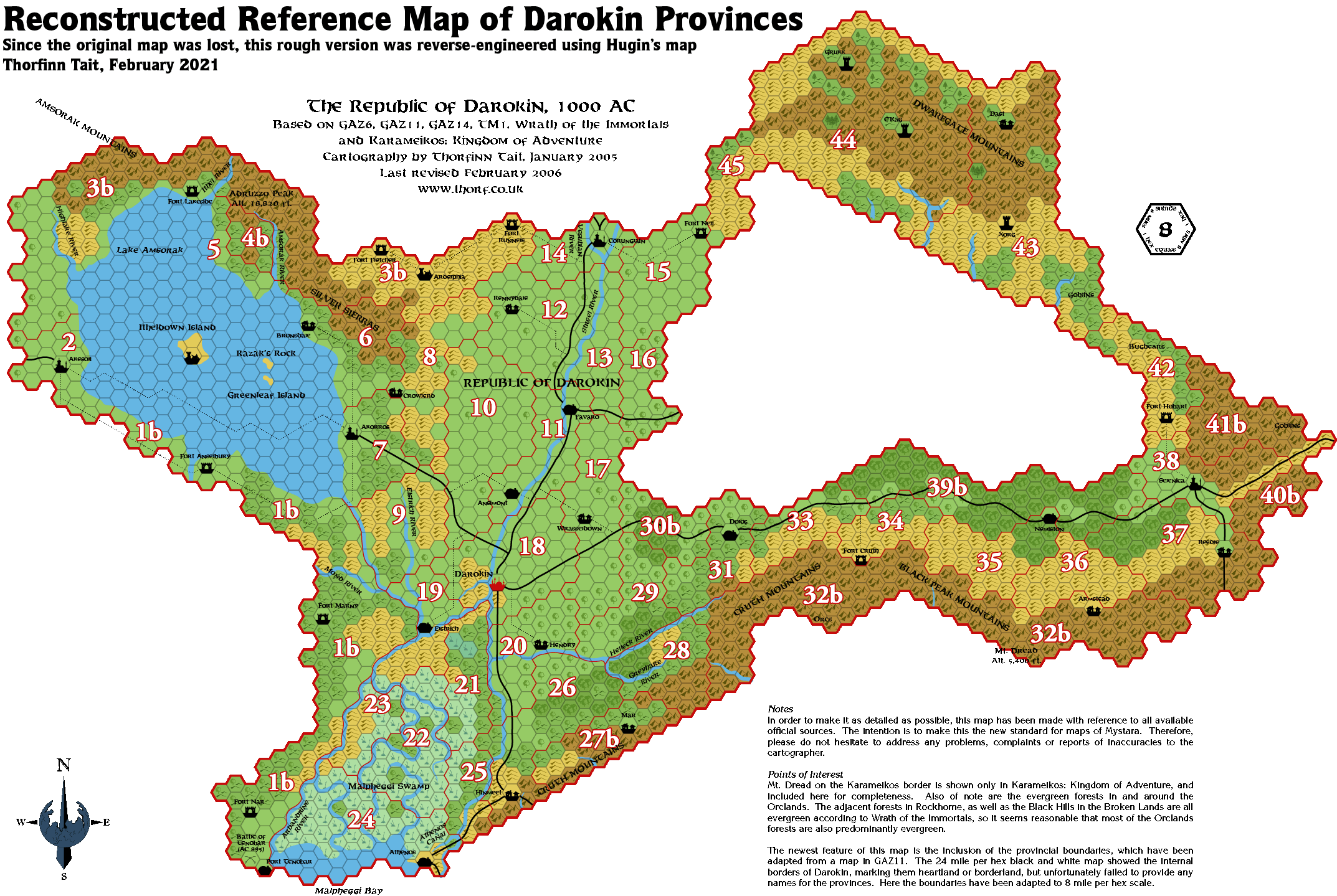
Doing so let me notice another error on the map; regions 12 and 13
(just south of Corunglain) lost their border line. Also, the gazetteer
suggests that regions 40b and 41b are separate. Difficult to say which
ruling would be canonical on that second one though, as the 24 mile
map disagrees sharply with the 8 mile map in that corner of Darokin.
1b - Atruaghin Borderlands (and Tenobar heartland region if you separate that out to make heartland council seat no. 37)
2 - Akesoli
3b - Glantri Borderlands
4b - ?
5 - ?
6 - Bronsdale
7 - Akorros
8 - Crowlerd
9 - ?
10 - ?
11 - Streel Valley
12 - Rennydale
13 - ?
14 - Corun's Glen
15 - South Nell
16 - ?
17 - Wrasseldown
18 - Darokin
19 - Elstrich
20 - Hendry
21 - ?
22 - Malpheggi
23 - ?
24 - Athenos
25 - ?
26 - Hinmeet
27b - Farshire (see my post downthread)
28 - Greyhare
29 - ?
30b - Dream Borderlands
31 - Dolos
32b - Traldar Borderlands (the name never got updated when Stephan took over)
33 - ?
34 - Cruth
35 - Nemiston
36 - Armstead (if border is moved south to include the village)
37 - Reedle
38 - Selenica
39b - Alfheim Borderlands
40b - ?
41b - ?
42 - Hobart
43 - East Dwarfgate
44 - West Dwarfgate
45 - North Nell
45 regions total, including 9 borderlands regions and 36 heartlands regions.
Issues:
Why is Tenobar, a major town and port, part of a borderlands
region? Presumably these regions were drawn up after Ardelphia got
sacked, as that too is in a borderlands region.
Most of the borderlands regions are extremely long and thin, unlike the
council regions. It would seem reasonable to suppose that borders
between magistrate regions have not been shown. Unfortunateley, that
does not explain the small magistrate region shown north of Lake
Amsorak (region 4b). I favour the idea that each borderlands
magistrate controls a single 24 mile hex of land, or 3 at most in
particularly poor regions.
The gazetteer says there are 37 heartlands regions, not 36 as drawn on
the map. And reading the entry on Darokin City hints at (though does
not explicitly deny the possibility of) the metropole does not count as
a separate region, spoiling one theory.
The gazetteer notes that borderlands magistrates can impose taxes more
or less on a whim, including road tolls, yet the major roads (including
the Darokin-Selenica route) pass through extended portions of
borderlands. Presumably the local magistrates are under standing orders not
to impose taxes that may interfere with traffic and trade on that road.
Last edited by Rhialto : 01-31-06 at 10:01 AM.
|
01-30-06, 09:47 PM
|
|
|
I suggest another approach in naming provinces:
In GAZ4 or GAZ9 you will have a set of counters with the names of many
warships of various Known World nations in peacetime conditions.
For Darokin we have:
Markuri
Akorros
Akesoli
Corunglain
Athenos
Illefarn
Selenica
Alfheim
Malpheggi
Darokin
Many of them seem to be just city names but others, such as Malpheggi
and Alfheim surely are not (why naming a ship with a foreign country
name such as "Alfheim"?). Moreover, I don't remember Darokinian cities
or towns named "Illefarn" or "Markuri".
It seems to me a bit strange that Darokinian ships took the names or villages.
What about if the list above reflects some Darokin provinces' names?
I've just read Rihalto's post.
You may have "Malpheggi" for region 22 and "Alfheim" for region 39b, for exampel.
|
01-30-06, 10:14 PM
|
|
Member
|
|
Join Date: Jan 2005
Location: Akita, Japan
|
|
Quote:
|
Originally Posted by Rhialto
Heartlands areas are ultimately controlled by a councillor. There are
37 dominions (cue controversy over the map disagreeing with this
number). Elections are held every 8 years, with the candidate list drawn up
by the incumbent - gerrymandering at its finest. These councillors elect 6
of their number to be the inner council, with the remaining 31
councillors forming the outer council.
|
It seems to me that the text is more important than the map when
it comes to this number, so it should be a relatively simple matter to
promote the missing region from an existing area labelled borderlands.
Quote:
I have uploaded a labelled version (numbers only) of the Darokin map,
to facilitate assigning names to the various regions. All regions are
numbered sequientially, with borderlands regions noted with a small B after
the number.
|
Thanks! I was considering doing this, but I didn't want to over-write the updated map.
Quote:
Doing so let me notice another error on the map; regions 12 and 13
(just south of Corunglain) lost their border line. Also, the gazetteer
suggests that regions 40b and 41b are separate. Difficult to say which
ruling would be canonical on that second one though, as the 24 mile
map disagrees sharply with the 8 mile map in that corner of Darokin.
|
Thanks for finding that error too. 
Regarding 40b and 41b, I will make them separate regions. You are entirely correct about the reason for them being joined.
Quote:
Issues:
Why is Tenobar, a major town and port, part of a borderlands
region? Presumably these regions were drawn up after Ardelphia got
sacked, as that too is in a borderlands region.
|
This one could have gone either way - Port Tenobar was on the
border of three 24 mi per hex hexes. I chose to put it in with the
surrounding countryside rather than the swamps, which brings up another
issue:
Why is the Malpheggi Swamp part of the heartlands? GAZ11 refers to it
as a wild region full of pirates, lizards, crocodiles, etc. Areas 22
and 24 especially are almost all swamp, and should definitely be
classed borderlands. But Athenos falls into area 24...
One solution would be to attach Athenos to area 25, and make Port
Tenobar and Fort Nar a new, small heartland province (1a). This would
kinda make sense, because having a town in a borderland is quite
strange.
While we're thinking of solutions for this, we should definitely
consider that the 24 mile per hex dominion border map and the 8 mile
per hex poster map are almost completely unrelated. Whoever did the
dominion map doesn't seem to have looked at the poster map (or they
made it before the poster map), because the dominions don't really have
much logic to them.
Quote:
Most of the borderlands regions are extremely long and thin, unlike the
council regions. It would seem reasonable to suppose that borders
between magistrate regions have not been shown. Unfortunateley, that
does not explain the small magistrate region shown north of Lake
Amsorak (region 4b). I favour the idea that each borderlands
magistrate controls a single 24 mile hex of land, or 3 at most in
particularly poor regions.
|
I'd rather just keep the borderlands as they are. It makes sense
in a whimsical sort of way that some borderland regions would be tiny
while others would be huge. Also, it would be much easier for
magistrates to enforce extra taxes and such in small dominions, so
perhaps there is that element to the sizes too.
In any case, the larger areas are probably divided up internally by
their ruling magistrate, and likely have delegated sub-rulers.
Quote:
The gazetteer says there are 37 heartlands regions, not 36 as drawn on
the map. And reading the entry on Darokin City hints at (though does
not explicitly deny the possibility of) the metropole does not count as
a separate region, spoiling one theory.
|
We can probably work around this while making the dominions a little more logical.
Another issue: why on earth are the Orclands considered heartland
territories?!? Bizarre. In reality they are more wilderness than
borderland, and it also seems likely that their magistrate is a
name-only position. We should definitely re-label these as borderland
territories. East Orcland and West Orcland might make good titles, too.
Quote:
|
The gazetteer notes that borderlands magistrates can impose taxes more
or less on a whim, including road tolls, yet the major roads (including
the Darokin-Selenica route) pass through extended portions of
borderlands. Presumably the local magistrates are under standing orders
not to impose taxes that may interfere with traffic and trade on that
road. |
This is a little strange, indeed. You might expect it to be the
case on borders, though. Note that it would be possible to extend the
borders of the neighbouring dominions slightly to encompass more of the
road, without disagreeing with the 24 mile per hex map. (In other
words, as long as the majority of the hexes making up the 24 mile hex
are borderland, the maps remain compatible.) |
01-30-06, 10:17 PM
|
|
Member
|
|
Join Date: Jan 2005
Location: Akita, Japan
|
|
Quote:
|
Originally Posted by LoZompatore
Many
of them seem to be just city names but others, such as Malpheggi and
Alfheim surely are not (why naming a ship with a foreign country name
such as "Alfheim"?). Moreover, I don't remember Darokinian cities or
towns named "Illefarn" or "Markuri".
It seems to me a bit strange that Darokinian ships took the names or villages.
What about if the list above reflects some Darokin provinces' names?
I've just read Rihalto's post.
You may have "Malpheggi" for region 22 and "Alfheim" for region 39b, for exampel.
|
This seems like a good idea, although I'm not so sure about using
other countries' names. I suppose we could call it the "Alfheim
Borderlands", though.
Certainly using the other names would make a good deal of sense.
For Malpheggi, Upper and Lower Malpheggi would work, allowing us to use it for two regions. |
01-30-06, 10:50 PM
|
|
Member
|
|
Join Date: Dec 2005
Location: I remember there was mist...
|
|
I
think, for the missing 37th council seat, the best solution would be to
promote the southern portion of area 1b (draw a line extending north
west continuing on from the northen border of area 24). Call that
council seat Tenobar, after the town within it. According to the
gazetter, Tenobar is definitely in the borderlands area though. This
needs retro-changing.
I'd place the islands in Lake Amsorak as part of area 5.
The border of area 36 should be moved south a little, to include the
village of Armstead, incidentally allowing the village name to be used
for the region name too.
re: Dwarfgate and Malpheggi: These are officially classed as
heartlands, not borderlands. The gazetteer notes that militarily
significant areas are taken over by the central government in the
interests of national security. I see no reason top demote them to
borderlands. As heartlands, their councillors are elected, which may
seem odd on the face of a presumably low local population. But given
the way election candidates are chosen, they seem like perfect examples
of "rotten boroughs".
re: Areas 40b and 41b: I think the best way to separate these would be
to give control of the road east and its valley to Selenica.
Putting Tenobar in area 24 and Athenos into 25 would work, but it would
definitely make it into a map that disagrees fundamentally with the 24
mile map in the gazetteer. It also doesn't solve the issue of the
missing 37th heartland region.
|
01-31-06, 12:05 AM
|
|
Member
|
|
Join Date: Mar 2001
Location: Italy
|
|
Quote:
|
Originally Posted by Rhialto
re:
Dwarfgate and Malpheggi: These are officially classed as heartlands,
not borderlands. The gazetteer notes that militarily significant areas
are taken over by the central government in the interests of national
security. I see no reason top demote them to borderlands. As
heartlands, their councillors are elected, which may seem odd on the
face of a presumably low local population. But given the way election
candidates are chosen, they seem like perfect examples of "rotten
boroughs".
|
Indeed. It may be the only reason why Dwarfgate is ever claimed
by Darokin, since it has almost no human population, is hardly
strategic for Darokin's defense (it's full of orcs!) and is remarkably
far from Darokin itself and its trade routes (being mostly shielded by
Alfheim). |
01-31-06, 01:10 AM
|
|
Member
|
|
Join Date: Jan 2005
Location: Akita, Japan
|
|
Quote:
|
Originally Posted by Rhialto
I
think, for the missing 37th council seat, the best solution would be to
promote the southern portion of area 1b (draw a line extending north
west continuing on from the northen border of area 24). Call that
council seat Tenobar, after the town within it. According to the
gazetter, Tenobar is definitely in the borderlands area though. This
needs retro-changing.
|
Yep, that certainly looks like the easiest way.
But I'm not sure why you say Tenobar is definitely in the borderland
area. As I mentioned above, it straddles a line at the edge of the 24
mile hexes. Of course, it is on the west side of the river, but even
that isn't sure proof when it comes to converting to 8 mile per hex.
Unless you meant in the text, but I couldn't find anything relevant myself.
Quote:
|
I'd place the islands in Lake Amsorak as part of area 5.
|
I chose not to extend borders out over the lake, not least
because the reference map didn't either. To be honest, I don't think it
matters about the islands though, given their nature.
Quote:
|
The border of area 36 should be moved south a little, to include the
village of Armstead, incidentally allowing the village name to be used
for the region name too. |
I considered that when I drew the original borders, but eventually decided against it.
In any case, I don't think taking regional names directly from villages
is necessarily a good idea. Though it is certainly the easiest option.
Quote:
|
re: Dwarfgate and Malpheggi: These are officially classed as
heartlands, not borderlands. The gazetteer notes that militarily
significant areas are taken over by the central government in the
interests of national security. I see no reason top demote them to
borderlands. As heartlands, their councillors are elected, which may
seem odd on the face of a presumably low local population. But given
the way election candidates are chosen, they seem like perfect examples
of "rotten boroughs". |
In other words, they exist on paper only. Okay. But it seems
highly unlikely that there is any population to speak of - unless you
count the orcs.
Quote:
|
re: Areas 40b and 41b: I think the best way to separate these would be
to give control of the road east and its valley to Selenica. |
That would work, but I'd rather give the area marked "Goblins" to
41b, and leave the last 24 miles of road belonging to 40b, since the
map did clearly have that last hex of road marked as borderlands.
Quote:
|
Putting Tenobar in area 24 and Athenos into 25 would work, but it would
definitely make it into a map that disagrees fundamentally with the 24
mile map in the gazetteer. It also doesn't solve the issue of the
missing 37th heartland region. |
And the latter point is really the deciding factor - there's
simply no point in doing it that way. It would take away the easiest
solution to the missing heartland region.
I've been starting to put in some of the province names, I'll hopefully
update the map sometime tomorrow, or perhaps later in the week. |
01-31-06, 01:41 AM
|
 |
Member
|
|
Join Date: Apr 2004
Location: Long Beach, CA
|
|
Quote:
|
Originally Posted by Thorf
Another
interesting point from those pages is that the heartlands are supposed
to have 37 different regions. I wonder if they are split up into that
many on the map... *Goes off to count*
|
Nope- I pointed this out recently in another thread- where were you?
Anyway, someone suggested that perhaps Darokin City itself is one of
the regions (so, the Darokin Heartland, and Darokin city) which would
bring the count to 37.
Also, as far as Province names, there is at least one Baron Corwyn
Markone IV in the Borderland region around Fort Lakeside (the fort
north of Amsorak- I think that's the fort's name). Maybe Markonia or
Markone?
I also think that the provinces are probably not all continuous
domains, but may be smaller (and even unclaimed) regions in and of
themselves (ie, not all are baronies or counties, but may contain
multiple such regions, and may include some territories that are not
really directly administered).
I've been thinking about this all a lot recently, actually. I'm also
wondering how such nobles would be addressed. Would it be, for
instance, "Lord Magistrate Corwyn Markone IV, Baron of Markonia?"
"Baron Corwyn Markone IV, Magistrate of Markonia?" or something else? |
01-31-06, 03:02 AM
|
|
Member
|
|
Join Date: Apr 2004
Location: Long Beach, CA
|
|
Quote:
|
Originally Posted by Rhialto
1b - Atruaghin Borderlands (and Tenobar heartland region)
|
Don't have my map handy at the moment, but isn't Tenobar a
Borderland region? It always seemed that way to me both from what I
recall of the map, as well as Tenobar's description in the Gaz (which
has it as sort of a semi-independent city-state competing with Athenos).
Quote:
Why is Tenobar, a major town and port, part of a borderlands
region? Presumably these regions were drawn up after Ardelphia got
sacked, as that too is in a borderlands region.
|
It's part of its character as a rugged frontier state. Think,
say, Tennesse in the early days of the Republic. Grudgingly part of the
new Republic, but fiercely pro-States' rights over Federal issues.
Quote:
The gazetteer notes that borderlands magistrates can impose taxes more
or less on a whim, including road tolls, yet the major roads (including
the Darokin-Selenica route) pass through extended portions of
borderlands. Presumably the local magistrates are under standing orders not
to impose taxes that may interfere with traffic and trade on that road.
|
I wouldn't be surprised if there were toll road deals with independent parties regarding the major roads.
As far as other provinces, I almost forgot to mention the Barony of
Fenhold (which is mentioned in the other thread, but should be included
here). Note to Thorf in particular about this one- there is some
discussion over there, IIRC, about the location of this province, and
how it doesn't fit with the original depiction (CM8) and the map in
Gaz11. |
01-31-06, 03:44 AM
|
|
Member
|
|
Join Date: Apr 2004
Location: Long Beach, CA
|
|
Quote:
|
Originally Posted by Thorf
Why
is the Malpheggi Swamp part of the heartlands? GAZ11 refers to it as a
wild region full of pirates, lizards, crocodiles, etc. Areas 22 and 24
especially are almost all swamp, and should definitely be classed
borderlands. But Athenos falls into area 24...
|
I have explained it, IMC, as there being native (Atruaghin)
peoples settled in that region, and there have been resulting clashes
between the settlers (Darokin) and the natives. The Council currently
is not quite sure how to deal with the situation- the Borderlanders
resent any intrusion by the "federal" government, but they need to
defuse tensions somehow. The result, at the moment, is folding the
Malpheggi regions into the Heartlands, until a more permanent solution
can be reached.
Quote:
|
One solution would be to attach Athenos to area 25, and make Port
Tenobar and Fort Nar a new, small heartland province (1a). This would
kinda make sense, because having a town in a borderland is quite
strange. |
See my previous post, but I don't find it all that strange at
all. Tenobar, by its description, seems very independent, and I could
freely buy their reluctant admittance into the Republic, with the
Borderland designation (so they could largely administer themselves).
Quote:
|
Another issue: why on earth are the Orclands considered heartland
territories?!? Bizarre. In reality they are more wilderness than
borderland, and it also seems likely that their magistrate is a
name-only position. We should definitely re-label these as borderland
territories. East Orcland and West Orcland might make good titles, too.
|
See the other thread for more discussion, but I imagine its
somewhat similar to the Malpheggi reason I had above. Troubles with
natives (orcs) and valuable mineral rights in the region would make the
Council want to have some sort of jurisdiction over the region, even if
there are few settlers foolish/brave enough to live there. Also note
that the Emerlas region of the Canolbarth (northern Alfheim) *does*
have settlers- some dwarves, humans, and halflings. |
01-31-06, 07:17 AM
|
|
Member
|
|
Join Date: Dec 2005
Location: I remember there was mist...
|
|
Just to explain how I named areas, I did the following:
- Where there was only one major settlement in the region, I named it after that settlement.
- Long thin borderlands regions were named after the nation they border.
- Creative license was used in a few cases:
-- 11 Streel valley - It has 2 towns, neither of which would probably
stand for the obvious loss of status in having the area named after the
other.
-- 14 Corun's Glen - The city info text notes this as an old name for the city.
-- 15 & 45 South & North Nell - They are on either side of Fort Nell.
-- 28 Greyhare - This region surrounds that river almost entirely.
-- 30 Dream Borderlands - This region borders the area of PC1 Tall tales of the Wee Folk.
-- 36 Armstead - As noted, I favour moving the border south to include that village.
-- 43 & 44 West & east Dwarfgate - They could of course just as
logically be named W/E orclands, but it seems more politic to name them
after your allies' name for the region than after your sworn enemies.
The rotten boroughs of the Dwarfgates and Malpheggi give rise to an
interesting adventure seed for high expert/low companion characters.
The rotten borough normally relies on a single (or group of)
settlements. Contact has been lost, and the players are sent by the
councillor to investigate. It turns out the community has been
annihilated. This is disastrous news for the councillor, as without a
voting population, the region will be re-assigned as borderlands (or
direct council control) when the next election comes (which may be
soon). The party is re-sent to lead a re-colonising expedition. they
are offerred a large reward for establishing a voting community, and
depending on teh whims of the GM, this may eventually lead to the party
getting control of the region in teh council, either by somehow
exposing the machinations of the previous incumbent, or him retiring
and nominating only party members for the election.
Incidentally, there have indeed been boroughs in various 'democracies'
in the past which only had a single family of eligible voters, so this
seed does have a basis in historical reality.
re: Tenobar. I guess it can also work if you keep it as a borderlands
town. That too could potentially give it a distinct character from
other towns in the nation, and variety is the spice of adventure after
all. The reason I am sure it must be in that borderland region is that
the 24 mile map has the entire area west of the river as being
borderlands, following the river course along the entire length. That
area includes the town.
re: councillor no. 37: The two ideas currently running are re-assigning
the southern portion of area 1 as a heartlands region, and making the
capital its own region. Both ideas were suggested by yours truly
I favour teh second one, as it also has the big advantage of not
requiring any large scale conflicts with the canon maps, and it doesn't
directly contradict any text.
The second option gives rise to some interesting political conflicts,
especially if the councillor for Darokin City disagrees with the
councillor for Darokin Province. UK observers can think back to Ken
Livingstone vs Thatcher and Blair, although the analogy isn't really
exact.
re: titles for magistrates. The gazetteer notes their official title is
magistrate, and that they have status broadly equal to barons in more
feudal nations. That baronial status is what makes me think their
domains (especially the long thin ones) should be subdivided, but just
leaving them as "xxxx Borderlands" and letting individual GMs works for
me.
Barons are normally addressed as "Lord/Lady xxxx" in the UK, and that
seems reasonable to extend to Darokin magistrates given their
hereditary status. Within their fiefs, magistrates are free to insist
their citizens address them with whatever title they like, and surely
many of them do indeed want to be called "Baron xxxx", somewhat similar
to the Alphatian "barons" on the isle of Dawn (pre-whoops). As an
aside, it seems reasonable to suppose that councillors get addressed as
"Councillor xxxx".
canonical magistrates/barons in Darokin include:
Baron Corran (WotI). Unsuccessfully tried to clear monsters out from
the region in 821 AC. The site is in the Glantri Borderlands region,
not far from the northern tip of Lake Amsorak.
Last edited by Rhialto : 01-31-06 at 07:42 AM.
|
01-31-06, 08:33 AM
|
|
Member
|
|
Join Date: Apr 2004
Location: Long Beach, CA
|
|
Rhialto
pointed out the Corran bit, which I was going to mention but forgot. I
was actually thinking that Baron Corwyn Markone IV's barony might be
the same one formerly owned by old Baron Corran, who sold off/gave up
to a relative his lands once his bride and child disappeared/died.
|
01-31-06, 09:21 AM
|
|
|
I note that no one has mentioned the Borderlands territory along the Selenica road which forms the basis of the CM9 Legacy of Blood
module. The dominion is called "Fenhold". Its location is not precisely
specified, but it would appear to be roughly in the location marked on
Rhialto's map as 33 - although it is slightly smaller than the
boundaries marked on the map (being one standard 24-mile hex dominion,
which a player inheirits in the adventure). It features a rather large
swamp, about 10 miles in diameter, around which the main road takes a
detour (alot of the adventure revolves around clearing the swamp so
that a causeway can be built through it and cut some distance off the
road). The module features a 4-mile/hex map which shows it in relation
to its surroundings and a 2-mile/hex map of the dominion itself. There
is some additional information contained that details information about
Darokin and some of the border regions (in particular, the ones
bordering Alfheim) which is not contained in the Gazeteer.
Quote:
|
Originally Posted by Rhialto
Issues:
Why is Tenobar, a major town and port, part of a borderlands
region?
|
The clue is that it's a port. Historically, many ports in
otherwise distant and "unsettled" lands grew quite large due to trade
and shipping, but often remained lawless as it was difficult for the
central authority to impose strict enforcement in these places. Tenobar
looks extremely removed from Darokin proper, so one would presume it's
a border town of this sort. |
01-31-06, 10:00 AM
|
|
Member
|
|
Join Date: Dec 2005
Location: I remember there was mist...
|
|
Story hook for area 27b
At 3 24 mile hexes, this is at what I consider the upper limit for the
'small magistrate domains' model, but the entire region could also be
considered one domain in the large magistrate domains model. So this
will work for everyone.
The region is called Farshire, and the magistrate is Sherif Jerred, a
halfling. It has most of the characteristics of the shires themselves
across the border. most of the halflings in Darokin will be found in
this territory (or Hinmeet). Mar (pop 400) is the nominal seat of
government, but that really just means it is where the sherrif lives.
it is similar in layout to most hin villages, except there is also a
cluster of human and dwarf houses above ground. This is the typical
layout of all communities in the area. Farshire has a reputation for
being a great place to avoid the bustle of big city life, as it is off
the main trade routes. The sheriff is keen to keep it that way, and
laws protect privacy quite well. The area is generally a lot less tamed
than the shires though, and outside teh villages, monsters of the kind
generally found in the shires and mountains are far more common.
Hin masters and knight-heroes can consider the Farshire to be part of the hin homeland.
Adventure hooks: abandoned orc/dwarf mines from their colonial days in
the shires, mysterious strangers with secrets to hide, trade missions
to open up the area for a merchant house, big bad monster threatens the
villages.
|
01-31-06, 10:42 AM
|
|
Member
|
|
Join Date: Apr 2004
Location: Long Beach, CA
|
|
Quote:
|
Originally Posted by Edgewaters
I note that no one has mentioned the Borderlands territory along the Selenica road which forms the basis of the CM9 Legacy of Blood module. The dominion is called "Fenhold".
|
I mentioned it a couple of posts up from yours. It has been discussed a bit before, in this thread.
Quote:
|
Its location is not precisely specified, but it would appear to be
roughly in the location marked on Rhialto's map as 33 - although it is
slightly smaller than the boundaries marked on the map (being one
standard 24-mile hex dominion, which a player inheirits in the
adventure). |
From the module, it seems to me to be clearly placed in the space
currently occupied by Dolos, actually- the 24 mile hex that covers the
region just south of Alfheim. Dolos would (by its appearance on the 8
mile hex maps) be in the area just south of the swamps of Fenhold. IMC,
I have moved Dolos just outside of the area, adjusting it a little bit
to the south.
I've actually got a 1 mile/hex map of the region that I began a long time ago, and have never quite gotten back to finish.
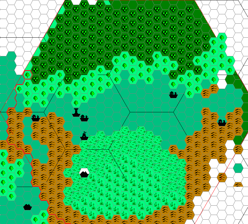
[EDIT- This is a really old map, and needs to be revised, and
(obviously) completed. Notably, the method of dividing 24 mile hexes
into 8 mile hexes I've since revised to meet the more likely TSR
standard- 7 8 mile hexes centrally located in the 24 mile hex- which
this one doesn't have. It should, hopefully, provide a visual
interpretation of the region for discussion, however.[/EDIT]
The town surrounded by white is the area where Dolos should occupy. The
town in the southwest is where I have moved it to- close enough to the
8 mile hex that it might be put there on a large scale map, and very
closely located to the Selenica road.
Quote:
|
The clue is that it's a port. Historically, many ports in otherwise
distant and "unsettled" lands grew quite large due to trade and
shipping, but often remained lawless as it was difficult for the
central authority to impose strict enforcement in these places. Tenobar
looks extremely removed from Darokin proper, so one would presume it's
a border town of this sort. |
I'd also add that, frankly, the Republic is very young (only 73
years old in the Gaz era). There are still a lot of lawless and
tenuously allied regions in the Republic. Most of the nation, as near
as I can tell (and have decided IMC) was formerly independent
City-States and petty dominions that decided recently (in the face of
growing national and international interests) to form a more unified
coalition.
The terms "Borderlands" and "Heartlands", IMO, are somewhat deceptive.
Yes, the Borderlands all actually Border other territories- but so do
some of the Heartlands. The Borderlands are not necessarily just
uninhabited and lawless regions; nor are the Heartlands all centrally
governed and populous.
IMO, many of the Borderlands are territories that- for one reason or
another (greed, bullying, fear of surrounding nations) have agreed to
become signatories to the Republic alliance, but only with the caveat
that they are able to maintain a great degree of their autonomy. Thus,
you have regions like Tenobar or Fenhold, where the rulers may be
surrounded by nations who might otherwise war with them, or interior
denizens who would rebel against local authorities, if they didn't have
the threat of Republic reprisals to sustain them.
Conversely, several of the Heartlands territories are areas that lack
large populations and local rulers, but contain assets that the
Republic covets (mineral rights) or are regions that require a degree
of stability that the Council must attempt to provide (my take on the
Malpheggi region near Tenobar).
Ideally, and in a long term sense, the Heartlands Council would like to
bring the Borderlands into the fold- as mentioned in the Gaz re:
buyouts and confiscation- but at the moment, the Republic is too young
to overtly exercise eminent domain, and too tenuously situated to risk
internal strife and possible international conflict. Too, as the
Republic stabilizes, some of the Borderlands domains might find it a
more appealing prospect to relinquish their autonomy and join the
Heartlands proper.
Last edited by Cthulhudrew : 01-31-06 at 10:48 AM.
|
01-31-06, 05:13 PM
|
|
Member
|
|
Join Date: Mar 2001
Location: Italy
|
|
Quote:
|
Originally Posted by Thorf
I'd
rather just keep the borderlands as they are. It makes sense in a
whimsical sort of way that some borderland regions would be tiny while
others would be huge. Also, it would be much easier for magistrates to
enforce extra taxes and such in small dominions, so perhaps there is
that element to the sizes too.
|
Note that if each borderland region is a single dominion, then we
have at least a few dominions that are way too large -- 1b strikes me
as being too powerful for a dominion: it controls a significant trade
route, one of the only two ports of Darokin, as well as three forts. Of
course it has dangerous borders with the Atzanteotl followers and the
Malpheggi swamp, but it also has a long stretch of plains along the
southern shore of Lake Amsorak, so it would be quite rich and strongly
defended -- yet it plays no role in the Darokin politics.
Also, Border Law is supposed to be simpler, and in many cases directly
administered by the Magistrate, which seems unlikely in the case of a
dominion as large as 1b or 32b.
Given also the existing information about Fenhold, where the barony is
one hex, I'd say that one 24-miles hex is the average size for a
dominion. Larger dominions might range to up to five or six hexes, but
these would not be as common. |
01-31-06, 08:21 PM
|
|
Member
|
|
Join Date: Jan 2005
Location: Akita, Japan
|
|
Quote:
|
Originally Posted by Agathokles
Note
that if each borderland region is a single dominion, then we have at
least a few dominions that are way too large -- 1b strikes me as being
too powerful for a dominion: it controls a significant trade route, one
of the only two ports of Darokin, as well as three forts. Of course it
has dangerous borders with the Atzanteotl followers and the Malpheggi
swamp, but it also has a long stretch of plains along the southern
shore of Lake Amsorak, so it would be quite rich and strongly defended
-- yet it plays no role in the Darokin politics.
Also, Border Law is supposed to be simpler, and in many cases directly
administered by the Magistrate, which seems unlikely in the case of a
dominion as large as 1b or 32b.
Given also the existing information about Fenhold, where the barony is
one hex, I'd say that one 24-miles hex is the average size for a
dominion. Larger dominions might range to up to five or six hexes, but
these would not be as common.
|
My reasoning is that the extreme size of some of the borderlands
areas, coupled with their lack of civilisation, population, and so on,
not to mention the lack of safety (quite severe in some areas), prevent
them from becoming extremely powerful.
In other words, they are big for that very reason. Silly laws and taxes
are going to be pretty hard to enforce over such a large area,
especially considering the probable lack of resources, and the total
lack of any population centres in most of the borderlands.
Also, when it comes to the forts and such, I assumed that the
magistrates of the borderlands don't have much control over the
military, even when they are within their domains. The military is
(presumably?) controlled by the council, adding just another reason why
being the magistrate for a large area is probably not at all an easy
job - and not all that profitable to boot.
When it comes down to it, all the arguments in this thread seem to be
either trying to explain what we see as strange things in the
Gazetteer, or else trying to change them so they make more sense. Most
of us have been doing a bit of both, but in the end it comes down to
individual judgement on which path you want to take. |
01-31-06, 11:54 PM
|
 |
Member
|
|
Join Date: May 2005
Location: Italy
|
|
Size of the Borderlands
I
tend to agree with Agathokles regarding the size of Borderlands
dominions. I think many of them should be one 24-miles hex in size,
while some of them would be larger (say from two to four 24-miles
hexes). The size of the dominion of Fenhold (from CM9) confirm this
approach.
The way I see Boderlands dominions is the following: the Kingdom of
Darokin in AC723 fragmented into many smaller indipendent kingdoms,
fiefdoms, dominions and city-states. Most of these political
organizations shared a common feudal structure (like the one you can
see today in the Borderlands).
When the Republic born in AC927, most of these dominions and
city-states were absorbed by the new political entity, becoming the
Heartland Regions of Darokin. Other dominions - perhaps of lesser
economic value to the merchant-rulers of Darokin, perhaps too
indipendent-minded, perhaps too costly to absorb given the difficult
terrain and monster presence - were left mostly to their own, save for
an oath of fealty to the Republic and some minor limitations of the
authority of their rulers.
So, today, these rulers still possess some old title (count, baron,
etc.), but to the Republica they're collectively known as "Magistrates
of the Borders", a term that is used to indicate their common agreement
and their common oath toward the Inner Council (and, by the way, sounds
far less "feudal").
This way, you could have two solutions:
1) Mantain larger Borderlands, like the ones you put on the map; in
this way the Magistrate of the Border would be the most important ruler
of the area, the one responsible for it in front of the Inner Council -
below him would be several rulers of smaller fiefdoms;
2) Shrink the Boderlands' sizes; every Magistrate rules and answer to the Inner Council for himself only.
P.S.: Like Ctulhudrew, I also came with a (different) solution to Fenhold's position. It's still found in the thread he indicated.
__________________
Looking for MYSTARA fans and news?
The Piazza: the new forum for MYSTARA and other TSR Campaign Worlds
Vaults of Pandius, the Mystara haven
Read Mystara threads on Gleemax.
"The prince should read histories, and in those consider
the deeds of excellent men and examine the causes of their victories
and defeats"
N. Machiavelli, The Prince, XIV, 5
|
02-01-06, 12:33 AM
|
 |
Member
|
|
Join Date: Mar 2004
Location: Ontario, Canada
|
|
I've
been doing some reading on Darokin's history to get an idea an how the
area developed and thus some names for various regions of Darokin. I'm
not finished yet by any means, but thought I could start by posting
some region names that would remain from Darokin's past as detailed in this article by Aaron Nowack (which I thoroughly enjoyed, btw; excellent work).
I'm of the school of thought that these provinces are more likely to be
named after what the local region has been historically refered to as.
The major cities are more likely to give there name to the surrounding
area then the smaller towns and villages, IMO. Plus, I find it
massively more interesting to give a province a historically
significant name than just that of the settlement that appears on the
map. (I hope to add some more history to Darokin for some of the
regions).
So far, my suggestions for some names are:
2. Akesoli
7. Akorros
9. Molharran
10. Irum (? see below)
11. Favaro
12. Daelbar (? see below)
13. Callair (? see below)
14. Corun's Glen (offically, but is also refered to as Corunglain by many)
15. Inlashar
16. Eastwind
17. Eraeda
18. Streel (it would be interesting to know where this name comes from)
18a? Darokin (I like the idea of the capital being a seperate 'province' too)
22. Central Malpheggi
23. West Malpheggi
24. Athenos
25. Malpheggi
26. Meruvar
Daelbar and Callair are from Geoff Gander's article
but I really don't know where they were actually located. If you see
this Geoff, could you let us know where they, and some of the other
named regions, would fit? That could fill in some more regions.
Well, that's my suggestions so far (still working on it). |
02-01-06, 02:02 AM
|
|
Member
|
|
Join Date: Jan 2005
Location: Akita, Japan
|
|
Quote:
|
Originally Posted by Zendrolion
1)
Mantain larger Borderlands, like the ones you put on the map; in this
way the Magistrate of the Border would be the most important ruler of
the area, the one responsible for it in front of the Inner Council -
below him would be several rulers of smaller fiefdoms;
|
That's definitely the best explanation for the bigger
borderlands, I think. The overall magistrate would assign dominions to
his various underlings, and the council only has to deal with the top
man.
Quote:
|
2) Shrink the Boderlands' sizes; every Magistrate rules and answer to the Inner Council for himself only.
|
Okay, so assuming that we were to do this, how would you want the
borderlands split up? It may sound picky, but the real main reason why
I don't like using a single 24 mile hex is that it's near impossible to
fit a provincial label in. 
Quote:
|
P.S.: Like Ctulhudrew, I also came with a (different) solution to Fenhold's position. It's still found in the thread he indicated.
|
Thanks for the link! I promise to get to CM9 and Fenhold as soon
as I can. (Right now I have picked up where I left late last summer -
wrestling with the Red Steel maps, trying to sort out their myriad
problems so I can steal the extra info.)
Quote:
|
Originally Posted by Hugin
I've
been doing some reading on Darokin's history to get an idea an how the
area developed and thus some names for various regions of Darokin. I'm
not finished yet by any means, but thought I could start by posting
some region names that would remain from Darokin's past as detailed in this article by Aaron Nowack (which I thoroughly enjoyed, btw; excellent work). |
Excellent idea! This is the sort of thing I was hoping for.
Quote:
|
I'm of the school of thought that these provinces are more likely to be
named after what the local region has been historically refered to as.
The major cities are more likely to give there name to the surrounding
area then the smaller towns and villages, IMO. Plus, I find it
massively more interesting to give a province a historically
significant name than just that of the settlement that appears on the
map. (I hope to add some more history to Darokin for some of the
regions). |
Yes, I wholeheartedly agree. Just naming all the provinces after
their geographical features begs the question, why bother labelling
them at all? It's okay for some provinces to have the same name and
city name, but all of them would look pretty unrealistic.
Thank you for researching these names!
Quote:
So far, my suggestions for some names are:
11. Favaro
16. Eastwind
|
Up at the top of the thread, Agathokles suggested Ansimont for 11, and Eastwind for 17. Can either of you explain your choices?
Quote:
18. Streel (it would be interesting to know where this name comes from)
18a? Darokin (I like the idea of the capital being a seperate 'province' too)
|
Yeah, it's clear that Streel/Streel Valley/Streel Plain or some
such name using "Streel" should come in somewhere. And obviously we
need a different name for this one if we are having Darokin as its own
region - we can't have two Darokins.
All in all, these are some great suggestions. Please let me know if you
can work out any more - historical names really are exactly what I was
looking for, and when we have Aaron's history available to us, it seems
a shame to waste the opportunity. |
02-01-06, 02:38 AM
|
|
Member
|
|
Join Date: Mar 2001
Location: Italy
|
|
Quote:
|
Originally Posted by Thorf
Okay,
so assuming that we were to do this, how would you want the borderlands
split up? It may sound picky, but the real main reason why I don't like
using a single 24 mile hex is that it's near impossible to fit a
provincial label in. |
No need to split them in the map: the larger Borderland regions
would be a patchwork of smaller domains (including some areas claimed
by the central government, like the forts) that would not pop up in the
large-scale map, but would be lumped together as they are, in large
administrative regions.
These administrative regions would be needed to manage "auditing" of
the magistrates (specifically, the Inner Council sends lawyers-envoys
to the magistrates to decide on the appeals that borderland citizens
can ask for in trials) -- regional department would oversee the local
officers.
Quote:
|
Up at the top of the thread, Agathokles suggested Ansimont for 11, and
Eastwind for 17. Can either of you explain your choices? |
Well, the Ansimonts and the Eastwinds were two of the mayor lines
of Kings in Darokin. I suppose that they took names from their original
lands (it happened often in RW). Both are supposed to come from central
regions, near Alfheim. Ansimont is there, and is in the most likely
position to be the cradle of the Eastwind tribes. The next best choice
is the bordering region, near Alfheim.
Region 16 is also a good choice for Eastwind, but I'd like something
closer to Favaro, which was the original seat of the Eastwind Kings.
I suppose one could also name region 11 Eastwind, due to the presence
of Favaro, but I prefer to think that Favaro was once part of region
17, but was later absorbed by region 11 as the Ansimonts grew stronger.
BTW, since Elstrich is both the name of the river and that of the city,
it's likely that regions 9 and 19 have names that contain "Elstrich",
like Elstrich Valley or Upper Elstrich for region 9, and Lower Elstrich
for region 19.
Last edited by Agathokles : 02-01-06 at 02:48 AM.
|
02-01-06, 03:39 AM
|
|
Member
|
|
Join Date: May 2005
Location: Italy
|
|
Quote:
|
Originally Posted by Thorf
That's
definitely the best explanation for the bigger borderlands, I think.
The overall magistrate would assign dominions to his various
underlings, and the council only has to deal with the top man.
|
If you choose this solution (i.e. larger borderlands divided into
smaller holdings) I think that the overall Magistrate would be chosen
by the Inner Council to hold that charge between the many lesser
dominion-rulers of that Borderland Region. He could be the most
powerful, influential, or rich of them all, or simply have strong
connections to the Republic's government. At the moment of his death,
the Republic choose his son or another noble to replace him.
This way, the GAZ11 phrase that stresses the Magistrate's hereditary
position would refer to the fact that he is the hereditary ruler of his dominion.
Quote:
|
Originally Posted by Thorf
Okay,
so assuming that we were to do this, how would you want the borderlands
split up? It may sound picky, but the real main reason why I don't like
using a single 24 mile hex is that it's near impossible to fit a
provincial label in. |
Well, you're not asking me an easy thing...
From canon material, we know the names of two Borderlands domains:
Fenhold (CM9) and Farstead (PC1), both located along Alfheim's southern
border - so detailing the borders of all the Borderlands fiefdoms would
mean creating the 99% of them from scratch!
Basically, if I'd had to complete a map of the Borderlands Regions, I'd use the following criteria:
- dominions in the mountains tend to be small (one or two 24-miles hexes);
- peaceful dominions would be a little larger (those along Sindhi,
Alfheim, or Atruaghin's northern border - say two to four 24-miles
hexes in size);
- the largest dominions would be located on the border with Glantri,
the Broken Lands and eastern Atruaghin (a larger dominion has access to
a larger amount of resoruces and income, and can defend itself better).
Even if you'll choose the "larger Borderlands" solution, I'd split most
of the existing Boderlands Regions into smaller ones, the borders of
which would follow the principles of an easier administration and of a
better defense, as follows:
- 1b would be split in two: west of Mond River, and south
of it; perhaps the large region south of Mond River could again be
split in half (For Marny in the upper 1b, Fort Nar and Tenobar in the
lower 1b);
- 3b would be split in four: the region from Akesoli
Heartland to the Highlake River (relatively peaceful), the one from the
Highlake to the Ithel River (Border Magistrare Baron Corwyn Markone IV,
from GAZ11, 'Lakeside' entry), the region from the Ithel River to the
Silver Sierras spur, and the region from the Silver Sierras to Fort
Runnels;
- 4b, if you go with larger Borderlands, this region makes
no sense as such; I'd rather unite it with one of the 3b regions (the
one that goes from the Ithel River to the Silver Sierras);
- 32b would be split in two, about half way between its two borders;
- 40b and 41b would be united in a single Borderland Region.
I'd leave other Borderlands Regions as you've put them.
Ah, another thing: what to do with Heartlands Regions nr. 22, 23, 24
and 42, 43, 44, 45? They're sparsely settled for sure and inhabited by
humanoids and other foul creatures - but nevertheless they're indicated
as Heartlands in GAZ11.
Could they - givern low population at best and dangerous wilderness -
be considered something like protectorates, ruled by governors (with
civil and military powers, perhaps chosen by the Inner or Outer
Council) that are in charge of that Regions but spend most of their
time outside them (i.e. in Darokin City)?
Quote:
|
Originally Posted by Thorf
(Right
now I have picked up where I left late last summer - wrestling with the
Red Steel maps, trying to sort out their myriad problems so I can steal
the extra info.)
|
I'm glad to see you back at work! Keep on, you're really doing a great work! |
02-01-06, 04:50 AM
|
|
Member
|
|
Join Date: Mar 2004
Location: Ontario, Canada
|
|
Quote:
|
Originally Posted by Thorf
(Right
now I have picked up where I left late last summer - wrestling with the
Red Steel maps, trying to sort out their myriad problems so I can steal
the extra info.)
|
Fantastic news!
Quote:
|
Thank you for researching these names!
|
It was quite a pleasure! There are some really great works done by fans.
Quote:
|
Up at the top of the thread, Agathokles suggested Ansimont for 11, and
Eastwind for 17. Can either of you explain your choices? |
No problem. First of all, I used this map
and also info from Geoff's article (bold are names I've used so far):
Quote:
The Duchy of Corunglain (proclaimed AC 628)
The Duchy of Ardelphia (proclaimed AC 647, destroyed by humanoids AC 846)
The Duchy of Callair (proclaimed AC 672, laid waste by humanoids AC 702, territory claimed by Corunglain AC 704)
The Kingdom of Daelbar (proclaimed AC 669, nearly destroyed by
orcs following Fall of Ardelphia, faded away by AC 875, territory
claimed by Corunglain AC 891)
...
The Duchy of Favaro (proclaimed AC 662, collapses in civil war AC 690, considered part of Streel Marches by AC 700)
Principality of Dirnath (proclaimed AC 678, collapses AC 686, part of Streel Marches AC 690)
The Duchy of Rondeth (proclaimed AC 685, despoiled by Red Duke of Irum AC 785, absorbed by Duchy of Amsorak AC 791)
Kingdom of Almarand (proclaimed AC 699, conquered by Darokin AC 914)
Barony of Sashenta (proclaimed AC 682, conquered by Duchy of Amsorak AC 756)
Duchy of Irum (proclaimed AC 690, obliterated by Darokin-Almarand alliance AC 807)
Barony of Eraeda (proclaimed AC 700, collapses AC 738, part of Streel Marches AC 740)
Barony of Nethlinn (proclaimed AC 693, despoiled by Red Duke of Irum AC 791)
|
The assumption that I'm using is that these latter duchies and
baronies occupied land that was originally part of the older 'nations'
depicted on the map above. In the example of #11, I assume that The
Duchy of Favaro sat on land originally part of the Eastwind lands and
so became known by that more resent name. The land to the east (#16)
did not fall under the Duchy of Favaro's borders and thus were still
known by the older name of 'Eastwind'. So there's my thought process.
(P.S. Geoff, if you see this, are you able to give locations for these
baronies? That would be absolutely great! Oh, and more maps of
historical times would be amazing!)
Quote:
|
Yeah, it's clear that Streel/Streel Valley/Streel Plain or some such
name using "Streel" should come in somewhere. And obviously we need a
different name for this one if we are having Darokin as its own region
- we can't have two Darokins. |
Exactly. Here's a thought that just hit me; if we use the
Doulakki peoples as one of the main initial human populations to spread
in Darokin, then I propose that 'Streel' (or a name on which that one
was based) was the name of one clan of Doulakki that first settled the
valley along this mighty river. Thus the region would have been refered
to as the Streel Clan's holdings. Any other ideas?
Quote:
|
All in all, these are some great suggestions. Please let me know if you
can work out any more - historical names really are exactly what I was
looking for, and when we have Aaron's history available to us, it seems
a shame to waste the opportunity. |
Agreed! I love this history stuff!
Last edited by Hugin : 02-01-06 at 11:21 AM.
|
02-01-06, 06:11 AM
|
|
Member
|
|
Join Date: Dec 2005
Location: I remember there was mist...
|
|
Here's
the updated, consolidated list, along with peoples' suggestions. I'm
trying to avoid assigning names that are separated by a mere
geographical divider, unless the area actually has little or no voting
population. The Dakotas would doubtless have had distinct names if they
had significant population, and Darokin's lands are no different.
Change log:
1 - Dropped the idea of Tenobar being separated out as a heartland
region. No one seems to have chimed in favour of it, and the capital
district option seems to have unanmous support.
2 - provinces previously named after villages are changed to ???, village name noted in brackets.
3 - Names from ships (GAZ4) Markuri, Illefarn placed by yours truly.
4 - Added "Darokin City" as the council seat no. 37.
5 - Molharran, Irum, Favaro, Daelbar, Callair, Inlashar, Eastwind, Eraeda, Meruvar placed by Hugin.
6 - Malpheggi regions named
7 - land 45 renamed, as "North xxxx" makes no sense without "South xxxx".
8 - Moved Callair from 13 to 15
---The List---
1b - Atruaghin Borderlands
2 - Akesoli
3b - Glantri Borderlands
4b - ?
5 - ?
6 - ? (Bronsdale)
7 - Akorros
8 - ? (Crowlerd)
9 - Molharran
10 - Irum
11 - Ansimont (honours the old line of kings, other names: Favaro, Streel Valley)
12 - Daelbar (Rennydale)
13 - ?
14 - Corun's Glen
15 - Inlashar (or Callair)
16 - Eastwind
17 - Eraeda (or Eastwind) (Wrasseldown)
18 - Streel (aka Darokin province)
19 - Elstrich
20 - ? (Hendry)
21 - Markuri
22 - Central Malpheggi
23 - West Malpheggi
24 - Athenos
25 - East Malpheggi
26 - Meruvar (Hinmeet)
27b - Farshire (see my post downthread)
28 - Greyhare
29 - Illefarn
30b - Dream Borderlands
31 - Dolos
32b - Traldar Borderlands (the name never got updated when Stephan took over)
33 - ?
34 - Cruth
35 - Nemiston
36 - ?
37 - ? (Reedle)
38 - Selenica
39b - Alfheim Borderlands
40b - ?
41b - ?
42 - Hobart
43 - East Dwarfgate
44 - West Dwarfgate
45 - Nell (or Callair)
46 - Darokin City
46 lands, including 37 heartlands and 9 borderlands
Last edited by Rhialto : 02-01-06 at 10:44 PM.
|
02-01-06, 11:15 AM
|
|
Member
|
|
Join Date: Mar 2004
Location: Ontario, Canada
|
|
I must first apologize immensely! I feel like a child who scribeled all over the Mona Lisa with some crayons!
But, I got a little curious as to what it would look like to place the
300 B.C. kingdoms on the 1000 A.C. Darokin map. I actually only did
this for my own sake but figured I might as well just post anyway. It
is NOT a work of art! I'm am no cartographer by any stretch of the imagination and had just quickly drawn this in using Paint.
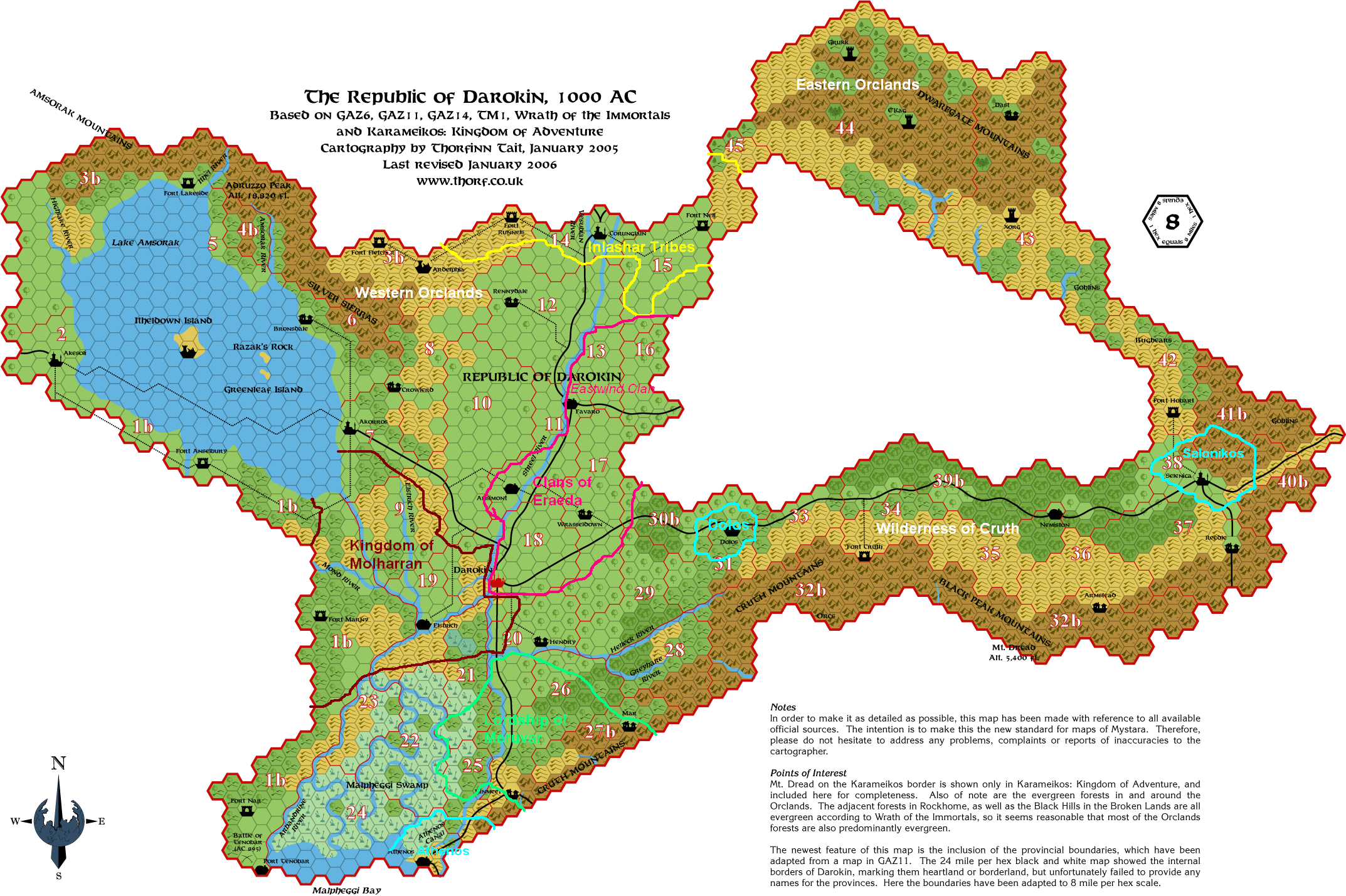 |
02-01-06, 11:15 AM
|
|
Member
|
|
Join Date: Jan 2005
Location: Akita, Japan
|
|
Quote:
|
Originally Posted by Zendrolion
If
you choose this solution (i.e. larger borderlands divided into smaller
holdings) I think that the overall Magistrate would be chosen by the
Inner Council to hold that charge between the many lesser
dominion-rulers of that Borderland Region. He could be the most
powerful, influential, or rich of them all, or simply have strong
connections to the Republic's government. At the moment of his death,
the Republic choose his son or another noble to replace him.
This way, the GAZ11 phrase that stresses the Magistrate's hereditary
position would refer to the fact that he is the hereditary ruler of his dominion.
|
That sounds fine to me.
Quote:
Well, you're not asking me an easy thing...
From canon material, we know the names of two Borderlands domains:
Fenhold (CM9) and Farstead (PC1), both located along Alfheim's southern
border - so detailing the borders of all the Borderlands fiefdoms would
mean creating the 99% of them from scratch! |
Pretty much, yeah.
Perhaps this is the best reason not to split up the borderlands much
more than they currently are. After all, it's good to have some
dominion space free for players too.
Quote:
Basically, if I'd had to complete a map of the Borderlands Regions, I'd use the following criteria:
- dominions in the mountains tend to be small (one or two 24-miles hexes);
- peaceful dominions would be a little larger (those along Sindhi,
Alfheim, or Atruaghin's northern border - say two to four 24-miles
hexes in size);
- the largest dominions would be located on the border with Glantri,
the Broken Lands and eastern Atruaghin (a larger dominion has access to
a larger amount of resoruces and income, and can defend itself better).
|
These sound like good criteria to me.
Quote:
|
Even if you'll choose the "larger Borderlands" solution, I'd split most
of the existing Boderlands Regions into smaller ones, the borders of
which would follow the principles of an easier administration and of a
better defense... <snip> |
You know, I think we're arguing different sides of the same coin
here. The only difference is whether there is one magistrate or many
magistrates - everyone seems to be in agreement that the borderlands
must be subdivided. The thing is, detailed subdivisions are not really
necessary on the map either way (especially since we'd have to think up
a ton of extra names too).
In other words, perhaps we have reached a consensus.
Also, subdividing the borderlands further on the map would make it
harder to see which areas are heartland and which are borderland. Of
course, this is arguably not necessary, as it could be shown on a
separate map easily enough.
Quote:
|
- 4b,
if you go with larger Borderlands, this region makes no sense as such;
I'd rather unite it with one of the 3b regions (the one that goes from
the Ithel River to the Silver Sierras); |
On the contrary, having large and small borderlands is not in the
least contradictory - it even says that there are both in the text on
pages 10 and 11.
In any case, mostly I think your splitting of the borderlands is quite
reasonable. The question is, do we want to mark those splits on the
map, and therefore have to name each region separately, or keep them as
descriptive text only?
Quote:
Ah, another thing: what to do with Heartlands Regions nr. 22, 23, 24
and 42, 43, 44, 45? They're sparsely settled for sure and inhabited by
humanoids and other foul creatures - but nevertheless they're indicated
as Heartlands in GAZ11.
Could they - givern low population at best and dangerous wilderness -
be considered something like protectorates, ruled by governors (with
civil and military powers, perhaps chosen by the Inner or Outer
Council) that are in charge of that Regions but spend most of their
time outside them (i.e. in Darokin City)?
|
It does seem unlikely that they are all actually elected by the
local populace. Probably some or all of them are heartland dominions in
name only, whereas in reality they have almost no civilised
communities, and the positions are similar to those of governments in
exile.
As for explaining their status, perhaps they are heartlands simply to
give them increased importance and priority at the council. There could
also be military connections.
Quote:
|
I'm glad to see you back at work! Keep on, you're really doing a great work!
|
Thanks.
Last edited by Thorf : 02-01-06 at 10:16 PM.
|
02-01-06, 09:59 PM
|
|
Member
|
|
Join Date: Feb 2005
Location: Ontario, Canada
|
|
Quote:
|
Originally Posted by Hugin
Geoff,
if you see this, are you able to give locations for these baronies?
That would be absolutely great! Oh, and more maps of historical times
would be amazing!)
|
I would be happy to oblige! I do have a later historical map of
Darokin, depicting all of the baronies, duchies, and kingdoms that
arose after the kingdom fell, set just after the time Favaro and
Dirnath collapsed, and became the Streel Marches. The only problem is
that I don't have ready access to a website at work, and my computer at
home is slow. So, if someone is willing to host the map, I would be
happy to email it to them.
I would also note that I have plans to produce a number of maps during
this time period, to reflect major historical events and border changes.
I'll get to the rest of the post as soon as I can.
Geoff |
02-01-06, 10:01 PM
|
|
Member
|
|
Join Date: Feb 2005
Location: Ontario, Canada
|
|
Quote:
|
Originally Posted by Hugin
But,
I got a little curious as to what it would look like to place the 300
B.C. kingdoms on the 1000 A.C. Darokin map. I actually only did this
for my own sake but figured I might as well just post anyway. It is NOT
a work of art! I'm am no cartographer by any stretch of the imagination and had just quickly drawn this in using Paint. |
This is very good, Hugin! A very useful tool for reference purposes.
Geoff |
02-01-06, 10:26 PM
|
|
Member
|
|
Join Date: Feb 2005
Location: Ontario, Canada
|
|
Here
are my preliminary comments to the list. Things are busy at this end,
so I'll likely be popping in for a few minutes here and there with more
thoughts.
Callair
Technically split between dominions 15 and 45 (about 2/3 is located in #15, so I would designate that one)
Molharran
#9 is an excellent choice. Although the bulk of Molharraners during the
kingdom's height of power lived in and around Elstarath (Elstrich) and
the lands immediately to the north and west, the region where #9 is
located now also contained several important towns and villages - many
of which, while still inhabited by people of Molharraner stock, are
considered backwaters now. Elstrich has long since become a more
cosmopolitan town - there is little left of the old capital city, aside
from the castle, remnants of the old wall, a few bridges, some roads
and statues, etc.
Irum
Irum was located between the Elstrich and Mond Rivers (where the
dominion of Molharran (#9) would be located today). I would add,
though, that due to the evil acts of Duke Rudgard between AC 765-795),
the name of Irum probably has negative connotations.
Daelbar (Rennydale)
Another excellent choice. #12 contains much of what was once Daelbar -
the rest is in #8. I would note that the ruins of Mintarm (the old
capital city) would be somewhere in #12, as well.
More to come!
Geoff
Last edited by Seer of Yhog : 02-02-06 at 01:19 AM.
|
02-02-06, 01:53 AM
|
|
Member
|
|
Join Date: Apr 2004
Location: Long Beach, CA
|
|
Just
a note about the 37 Heartlands (and apologies if someone else suggested
this and I just missed it). Maybe we could split one of the Heartland
territories that is divided by the Streel River into two Heartlands? In
particular, the Heartland that is split with Ansimont on one side and a
different town on the other might be eligible? Or even the Darokin
heartland territory (which is also split).
Could be a possibility.
|
02-02-06, 01:59 AM
|
|
Member
|
|
Join Date: Feb 2005
Location: Ontario, Canada
|
|
More comments to the list:
1b
You could use the name of Nethlinn, one of the realms destroyed by Irum.
4b - ?
4b occupies the western half of Brethilad, the reclusive elvish kingdom
that was destroyed many centuries ago. Aside from (IMC) a group of
monks inhabiting the former fortress of Brethilad, hardly anyone lives
in the Amsorak River valley today; although the entire area is prevaded
by a sense of peace, and loss. Of course, reclusive homsteaders and the
like could easily have moved in (orcs give the place a wide berth).
8 - ? (Crowlerd)
The Duchy of Rondeth occupied parts of dominions #8 and 10.
11 - Ansimont
Ansimont was the capital of Almarand from the time of its founding (AC
699) to the kingdom's final collapse in AC 914. The kings of Almarand
claimed to be the legitimate heirs of the old Darokinian Kings - part
of what spurred the often nasty fighting with Darokin to the south for
many years. There would probably be many people in influential
positions in Darokinian society who would rather not see the name of
Almarand appear on any map - the same people who would rather not see
the current king (now in exile) ever return to the republic.
17 - Eraeda (Wrasseldown)
Another excellent choice. During the period following the collapse of
the kingdom, one ambitious soul, claiming to be descended from the old
lords of Eraeda, claimed the region around Wrasseldown for himself, and
crowned himself Baron of Eraeda in AC 700. The realm lasted long enough
to be passed on to his son, who was assassinated (some say by
Darokinian agents) in AC 738, after which the barony dissolved into
feuding fiefdoms, and was generally considered part of the Streel
Marches before being pacified by Darokin in the 9th century.
Even so, the romanticised history of the first kingdom of Eraeda lives
on in many songs (some from Ansel Darokin's time), and most Darokinians
are likely familiar with the name, and probably claim some form of
kinship with it (regardless of what their true ancestry might be). The
current magistrate, or whoever runs the place, might very well claim
descent from the old Eraedan lords, too (although he would likely be
more circumspect about it).
26 - Meruvar (Hinmeet)
From the timeline that Aaron and I wrote, almost all references to
Meruvar were destroyed after that realm's fall, owing in large part to
the blasphemous practices permitted by its lord. Even its capital city,
Ardannon, was torn apart stone by stone, and cast into the swamp.
Still, some fragmentary references managed to avoid detection (how else
could adventurers be lured there?), and so the region might be named
after the old capital, perhaps - maybe something like Ardann, Aerdan,
Dannon, Ardon, etc. Just an idea, which could be a possible adventure
hook in itself.
27b - Farshire (see my post downthread)
Interesting! In my own fragmentary work (still needs to be fleshed
out), I had developed the concept of the North Shire. Basically, after
the collapse of the kingdom, hin in the region began to forge ties with
their cousins to the south - largely for security, but also out of
cultural affinity. Things progressed, and it soon looked like the North
Shire would join the Five Shires. The Darokinians, unwilling to let a
portion of what they considered their land to secede, made a few
gestures to encourage the hin to rethink their plans, and encouraged
more human settlement of the region. Knowing that any retaliation
against the human settlers would bring nasty consequences, and the
money and support being offered by the Darokinians would be useful to
them, the hin acquiesced, and the North Shire was reincorporated
without a proverbial shot being fired.
30b - Dream Borderlands
An alternative is Comaelle (again, from Aaron's timeline). Although the
legendary city of the Eraeda is lost, many historians believe that it
was located somewhere along the western fringes of the Canolbarth
Forest. In reality, it's probably located in #17 or #13, but they could
easily have selected this location.
45 - Nell (or Callair)
This is where I would probably put Inlashar, mainly because the hilly
country here is where the bulk of those people with the strongest
Inlashar bloodlines live. Large concentrations also exist further west
(and in Corunglain, and at one time in Ardelphia), but this is where
the local rulers might logically be able to claim descent from some old
chieftain - the authorities probably would have recognised the claims
in order to keep them quiet, and to help ensure their loyalty.
Geoff
|
02-02-06, 03:01 AM
|
|
Member
|
|
Join Date: Mar 2004
Location: Ontario, Canada
|
|
Quote:
|
Originally Posted by Seer of Yhog
I
would be happy to oblige! I do have a later historical map of Darokin,
depicting all of the baronies, duchies, and kingdoms that arose after
the kingdom fell, set just after the time Favaro and Dirnath collapsed,
and became the Streel Marches. The only problem is that I don't have
ready access to a website at work, and my computer at home is slow. So,
if someone is willing to host the map, I would be happy to email it to
them.
|
I use Imageshack to host images on the web (it was recommended to
me by someone on this board some time ago and come in real handy). If
you'd like, just email any maps to me at morris_of_nfld@yahoo.ca and I could get them posted here via Imageshack. Either way, I HAVE to see those maps!
Quote:
|
I would also note that I have plans to produce a number of maps during
this time period, to reflect major historical events and border
changes. |
Yes! Now you have to!
Thanks for all the info. I'm going to look into it all to see about changes we should make to our names, given the new info.
P.S. I'm also in the middle of writting up the History of the Dwarfgate
Mountains Region. I should be able to finish it today and get it posted
(likely in a new thread come to think of it). |
02-03-06, 05:07 AM
|
|
Member
|
|
Join Date: Mar 2004
Location: Ontario, Canada
|
|
Here's Geoff's Darokin 700 AC map showing the locations of the baronies, duchies, and kingdoms from his article on the Vaults. Excellent work Geoff! Thanks!
 |
02-03-06, 06:37 AM
|
 |
Member
|
|
Join Date: Feb 2006
Location: Rome, Italy
|
|
Hi all!
I'm the Giovanni Panniccia who started the idea of finding Darokin dominions in Thorf's map.
I'm glad to see it was a liked idea, with a great following.
I'm also very glad to see this forum, in the official WotC page. I hope
to find here lots of nice people and (more of all) Mystara lovers!
|
02-03-06, 11:12 AM
|
|
Member
|
|
Join Date: Mar 2004
Location: Ontario, Canada
|
|
Here's
an updated list with my suggestions. It has only the heartlands seeing
as how it is likely that the borderlands are divided into smaller
domains and therefore named after them, instead of being named after a
geographic region like the heartlands. Also, I placed my thoughts
behind the choices in parenthesis so you can see my reasonings.
2 - Akesoli
5 - Brethald (a deteriation of Brethilad)
6 - Gairsland (made-up name of someone who controlled much of this territory when Darokin was formed a century ago)
7 - Akorros
8 - Rondeth
9 - Molharran
10 - West Streel (one of a few regions designated Streel due to various reasons. This one was part of the Streel Marches)
11 - Almarand (named after an older dominion to avoid any political complications of using either Anismont or Favaro)
12 - Daelbar
13 - North Streel (this area was also part of the Streel Marches)
14 - Corun's Glen (offically titled Corun's Glen but it is very often refered to as Corunglain)
15 - Callair
16 - Eastwind
17 - Eraeda
18 - Central Streel, aka Darokin province (was not named after any person or political entity for political reasons)
19 - Elstrich
20 - South Streel
21 - Markuri
22 - Central Malpheggi
23 - West Malpheggi
24 - Athenos
25 - East Malpheggi
26 - North Shire (a token move from the Great Merger to sway the
halflings there to participate in the creation of the new Republic)
28 - Greyhare Shire (see above. This name developed later out from North Shire)
29 - Illefarn
31 - Dolos
33 - Fenhold (I know there has been discussion about this but from what
I understand it should be able to go here. If not, let me know)
34 - Cruth (It's an interesting possibility that this region's history may have given the name to the mountain range; maybe)
35 - Nemis (the town's name deriving from the region)
36 - Isselden (an elf may have had something to do with this region's past...)
37 - Dolak (name descended from the ancient name of the Doulak Valley)
38 - Selenica
42 - Hobart (Selenican hero who spearheaded the defense of the area in the early years of the new Republic's life)
43 - East Dwarfgate
44 - West Dwarfgate
45 - Inlasher
46 - Darokin City
So, there's a list of all the heartlands. Comments?
|
02-03-06, 04:12 PM
|
|
Member
|
|
Join Date: Jan 2005
Location: Akita, Japan
|
|
Great work, everyone! Especially thanks to Hugin and Geoff, and Rhialto for doing the original lists.
I will take Hugin's latest list and do a preliminary workup of the map, although I can still change it at request.
Unfortunately, I will not have Internet access again until late next
week, so I doubt I will be able to post the updated map until then. See
you next week!
|
02-03-06, 05:45 PM
|
|
Member
|
|
Join Date: Dec 2005
Location: I remember there was mist...
|
|
I
have a bit of an issue with 10, 13, 18, and 20 from Hugin's list. they
are all "xxxx Streel". Nothing wrong with regional designators based on
major terrain features in itself. But it feels odd for such a central
area for a few reasons:
- historically, such name patterns refer either to recently colonised
and spaersely populated areas (Dakota), areas politically divided by a
war (Germany, Korea, Vietnam), or once-sparsely populated areas that
had major demographic shifts (Yorkshire). None of those seem to apply.
- The areas in question do NOT form a contiguous area, which is utterly at odds with any real-world precedent.
Also, I'm a bit uneasy about 26 and 28 being "xxx shire". GAZ11 says
halflings aren't particularly common in Darokin. having one land as the
"shires modifed by darokin" is good for interest, but I can't really
see a campaign role for two. Plus I see the borderlands on that border
as filling that role anyway. Those two lands, plus the borderland that
they encircle, total almost 50% of the entire shires, which seems a bit
excessive for an enclave.
A case could be made for having the majority of the SE lands being
named "xxxx Shire" in honour of the Hin naming convention, but
relations, while very good, don't strike me as being that good.
Apart from that, I'm happy with that list.
The first name in the following list is my first choice, followed by
alternative names that have been proposed (in no particular order).
10 - Wesmar or Westmark (A corruption of west march), Irum, West Streel
13 - Ismar or Eastmark (A corruption of east march), Callair, North Streel
18 - Darokin Province, Streel, Central Streel
20 - Helleck (after the river), Hendry (after the village), South Streel
26 - Hinmeet (after the village), Meruvar (but records of this kingdom have been purged), North Shire
28 - Greyhare (after the river), Greyhare Shire
Although generally there is a good reason not to name lands after
villages, given the Village of Hinmeet's location on the major trade
route, a case could be made for it being an important centre in its own
right, and the low population simply being a result of typical Hin
opinions on urban development. Hinmeet (land 26) would be halflings as
seen under full Darokin law and a councillor, while Northshire/Farshire
(land 27) would be halflings as seen under marginal/borderlands Darokin
law, complete with Hin-style sherrif (magistrate).
|
02-03-06, 10:00 PM
|
|
Member
|
|
Join Date: Feb 2005
Location: Ontario, Canada
|
|
Quote:
|
Originally Posted by Rhialto
I
have a bit of an issue with 10, 13, 18, and 20 from Hugin's list. they
are all "xxxx Streel". Nothing wrong with regional designators based on
major terrain features in itself. But it feels odd for such a central
area for a few reasons:
|
One of the territories could just be called "The Marches" - #13
would probably be the best one, as that region was considered part of
the Streel Marches for a very long period of time. It covered much of
the old Duchy of Favaro, which was one of the first petty nations to
collapse.
The people who lived in that region spent the better part of 200 years
on their own, and by the time of the Great Merger, they probably saw
themselves as a community unto themselves. Some people in that part of
the republic might even still call themselves "March Men" or "March
Women" with pride...
Geoff |
02-04-06, 01:55 AM
|
|
Member
|
|
Join Date: Apr 2004
Location: Long Beach, CA
|
|
Quote:
|
Originally Posted by Rhialto
Also,
I'm a bit uneasy about 26 and 28 being "xxx shire". GAZ11 says
halflings aren't particularly common in Darokin. having one land as the
"shires modifed by darokin" is good for interest, but I can't really
see a campaign role for two. Plus I see the borderlands on that border
as filling that role anyway. Those two lands, plus the borderland that
they encircle, total almost 50% of the entire shires, which seems a bit
excessive for an enclave.
|
I'd tend to agree with this in regards to 28, especially (as
Rhialto noted) because of the Borderland nature of 28, and it is
mentioned specifically that Hinmeet was created as a waystation/trading
post between the two nations.
Quote:
|
10 - Wesmar or Westmark (A corruption of west march), Irum, West Streel
|
I kind of like Westmark myself.
Quote:
|
26 - Hinmeet (after the village), Meruvar (but records of this kingdom have been purged), North Shire
|
I don't really like Hinmeet myself- it's just a village, after
all, and a fairly new one at that. Given that the size of the domain is
much larger than just that village, I think another name would work
better. I kind of like a "Shire" name, but given the location of it
(more inland from the Shires than not), I don't know that it feels
quite right. |
02-04-06, 02:37 AM
|
|
Member
|
|
Join Date: Mar 2004
Location: Ontario, Canada
|
|
Good comments, guys.
Quote:
|
Originally Posted by Rhialto
10 - Wesmar or Westmark (A corruption of west march), Irum, West Streel
|
Quote:
|
Originally Posted by Seer of Yhog
One of the territories could just be called "The Marches" - #13 would probably be the best one...
|
I love the sound of 'The Marches'! And then we could have #10 as
'Westmark'. Much better than mine. It's the same kind of thinking that
I wanted but I couldn't come up with anything better than xxxx Streel
(plus, it was late )
Quote:
|
Originally Posted by Rhialto
18 - Darokin Province, Streel, Central Streel
|
I liked Darokin Province better myself as well (that's why I put
it in as an a.k.a.), but I was trying to have some kind of 'Streel'
thing going... Since we have something better now I have no use for
using xxxx Streel.
Quote:
|
20 - Helleck (after the river), Hendry (after the village), South Streel
|
Of these I like 'Helleck' best, but maybe someone could make up a
name (and perhaps a brief history behind it) for the area. Or, maybe a
variation of the word Helleck.
Quote:
26 - Hinmeet (after the village), Meruvar (but records of this kingdom have been purged), North Shire
28 - Greyhare (after the river), Greyhare Shire
|
The idea behind the 'Shire' idea actually came from the Vaults
(at least I think so now). I read it when doing up my history of the
Dwarfgate Mountain Region and then when I came back to this I couldn't
find it anymore! 
I don't remember the details but I do remember liking the story. I
recall that the naming of the heartland ????? (what *do* we call the
heartland regions? districts?) was a concession to keep the hin of the
area from leaving for the Five Shires. Man, I really want to find that
article again... grrrr. This area would be significantly different from
the Shires though, considering the fact that they moved out of the
Shires and the much greater human population that intermingles with
them.
As for the borderlands there, I'm inclined to think they are not ruled
by any halflings for political purposes related to needs at the time of
the Great Merger. Since no halflings were to be 'rulers', Darokin had
to use other ways to keep the hin positive towards the Repubic's
formation.
Perhaps we could use single words (i.e. Northshire and greyhareshire)
to give a better sense of being shire-like but significantly different?
Thoughts? |
02-04-06, 04:34 PM
|
|
Member
|
|
Join Date: Dec 2005
Location: I remember there was mist...
|
|
For
the marches, I'd rather have "Westmark" and "Eastmark" as teh official
names, and that way, we leave "The marches" as a popular way that
locals refer to their area collectively. As far as they are concerned,
its all The Marches, regardless of what those idiot bureaucrats in
Darokin City may say.
For Darokin Province, I can see a decent case for renaming it to
"Streel valley". It's like, there's a Darokin Republic, Darokin
Province, Darokin City, and probably a Darokin Quarter complete with
Darokin Alley. Give the name a rest already! Perhaps "Darokin City" the
council seat region should be renamed to something else too. "Capitol"
sounds good.
Regarding the provinces brodering the Shires, naming them xxxxshire (no
space) wouldn't fix anything. That's the standard naming convention
both in the real world and within the Hin homelands, and is utterly
cosmetic in any case. Having the space is simply wrong.
I imagined the Hinmeet heartland currently being held by a Hin
councillor, who got in quite by chance, and perhaps an informal
consensus exists among rich hin to only nominate other hin for election.
The borderland on the shires may be even more interesting. Historically
inhabited by many hin (though not utterly dominated like the shires
proper), but isolated from the main hin communities by the mountains,
it was easier to seek support from the humans in Darokin rather than
the Shires. At the same time, the sheriff never fully identified with
human culture, and the strong privacy attitude and continuing legal
status as a borderland is the result.
Regarding national naming convention for the provinces, I favour "xxxx
heartland" or "xxxx borderland", with "xxxx land" as the generic name.
|
|
|

