Darokin Provinces
A recreation of the Wizards of the Coast Mystara Message Board thread, with restored links and images.

02-04-06, 05:26 PM
|
|
|
Cool
to see all this work done. My campaign will be returning to Darokin
this Spring, and in my other campaign I wlll be DMing a short session
in a civil war -state Darokin. These will be extremely useful.
To make this thread useful in a more permanent manner, perhaps someone
involved could collate the information into a document and send it to
to Shawn's Vaults? There's already a lot of usefull stuff on Darokin,
and this would complement it nicely.
|
02-06-06, 11:23 PM
|
|
Member
|
|
Join Date: Feb 2005
Location: Ontario, Canada
|
|
Quote:
|
Originally Posted by Rhialto
For
the marches, I'd rather have "Westmark" and "Eastmark" as teh official
names, and that way, we leave "The marches" as a popular way that
locals refer to their area collectively. As far as they are concerned,
its all The Marches, regardless of what those idiot bureaucrats in
Darokin City may say.
|
This sounds perfectly reasonable to me. On a map, they would be
Westmark and Eastmark, but anyone passing through the second would
probably get blank looks, or a smirk, if they used those names. I'll
definitely have to note this in my slowly coalescing resource on
Darokin.
Geoff |
02-19-06, 06:30 AM
|
 |
Member
|
|
Join Date: Jan 2005
Location: Akita, Japan
|
|
 Update
Just a heads up that I have updated the Darokin map.
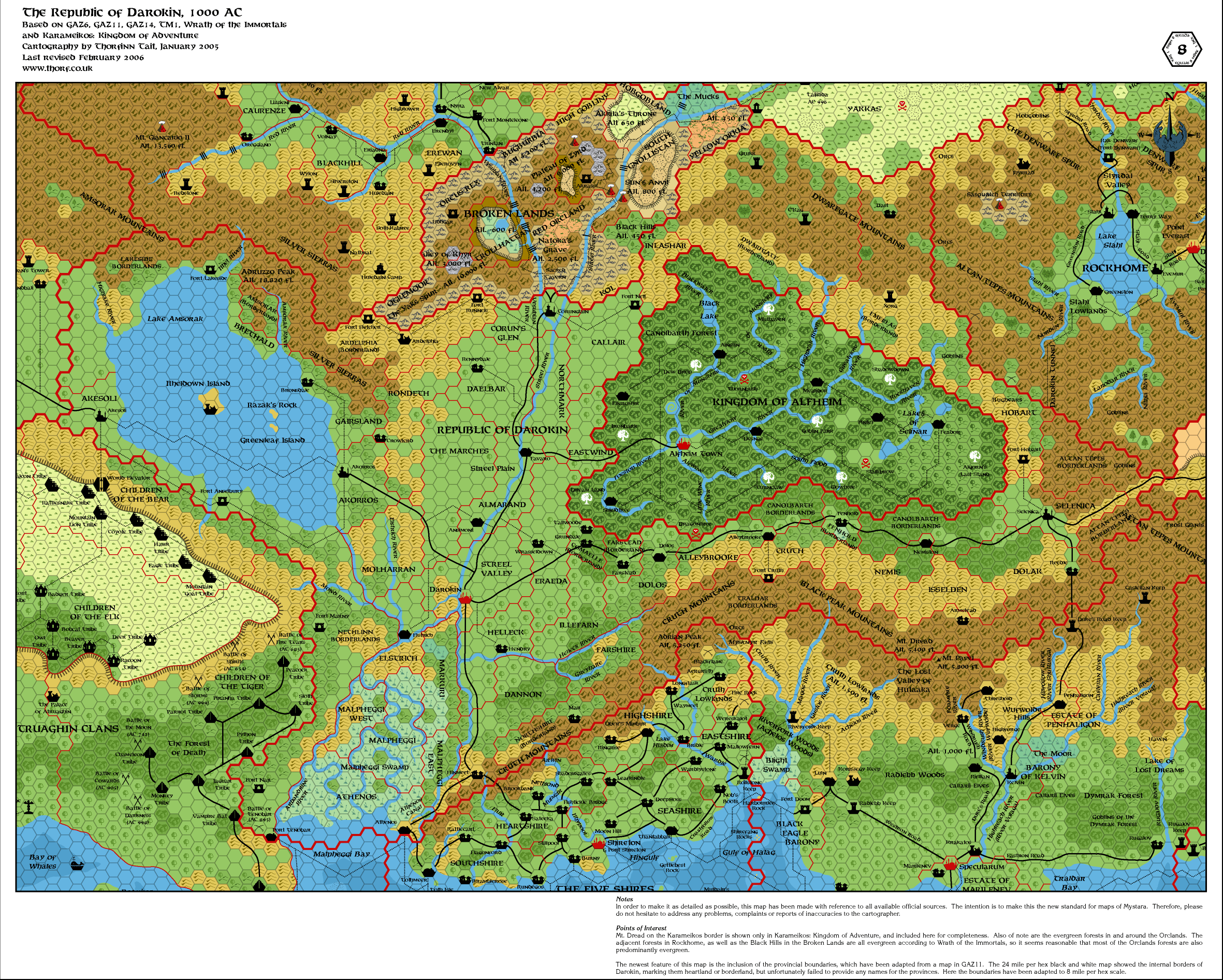
I'm sure there will be some comments on the names I ended up using. I'm still open for changes. |
02-19-06, 06:50 AM
|
 |
Member
|
|
Join Date: Dec 2005
Location: I remember there was mist...
|
|
First up, WOW to the new style and the inclusion of neighbouring countries. 
Regarding province names...
- I'm not sure Ardelphia was actually a separate territory from the
Lakeside borderlands. It certainly deserves to be though, given the
geographical distance. In any case, it should be marked as a borderland.
- I strongly believe the various "marches" lands should be adjacent
(see my explanation for why upthread). This applies to "The Marches",
"Northmark", and "Southmark".
- There's no historical basis for having a march-styled land where Southmark is.
- Kudos on having the good sense to use "Canolbarth" instead of "Alfheim" for that borderland.
- "Amsorak", "Northshire", and "Camaelle" probably need to be identified explicitly as borderlands. |
02-19-06, 07:31 AM
|
 |
Member
|
|
Join Date: Apr 2004
Location: Long Beach, CA
|
|
Quote:
|
Originally Posted by Rhialto
-
I'm not sure Ardelphia was actually a separate territory from the
Lakeside borderlands. It certainly deserves to be though, given the
geographical distance. In any case, it should be marked as a borderland.
|
Ardelphia was destroyed in 846 AC, over 80 years before the Great
Merger, so there were never any Borderlands when it was still a
populated city. As such, I kind of question the naming of that region
as "Ardelphia", simply because it seems unlikely (to me) that they
would name a region after a city that they never even bothered to
rebuild or reclaim (it's one of their biggest failures).
Also, East Dwarfgate might be termed the Emerlas (or some versoin of
that), as that is how that region is known to the elves. Then again,
maybe not.
Fenhold is a lot bigger than it is depicted in CM8. That goes back to
the idea that the borderlands should actually be broken into smaller
administrative units, though, I suppose. |
02-19-06, 07:54 AM
|
|
Member
|
|
Join Date: Dec 2005
Location: I remember there was mist...
|
|
If
a land is named "Ardelphia Borderland", it would be an Alamo-esque
reference, rather than being named after the city as a living entity.
|
02-19-06, 08:26 AM
|
 |
Member
|
|
Join Date: Feb 2006
Location: Rome, Italy
|
|
Maybe the region was already known as "Ardelphia", the town and the countryside too.
I like the work very very much. But I miss Farstead Dominion.
I like very much the neighbouring countries! Now we have a complete
Darokin - Alfheim - Upper Broken Lands map! Quite nice, and you can
travel a lot  |
02-19-06, 04:09 PM
|
|
Member
|
|
Join Date: Apr 2004
Location: Long Beach, CA
|
|
Quote:
|
Originally Posted by Rhialto
If
a land is named "Ardelphia Borderland", it would be an Alamo-esque
reference, rather than being named after the city as a living entity.
|
I suppose, it just seems strange to me that 80+ years after the
fact, and after the nation has undergone a major political
transformation, that the region would be known after a city that has
not been inhabited in a generation or two, rather than, say after a
particular noble who rules there or his dominion, or so forth. I would
find the latter situation far more likely. After all, if Ardelphia has
not been reclaimed in all of that time, it seems that the central focus
of the inhabitants of the region are more on some other area- a
village, or other aspect of the region (maybe they're vintners, or
something, and the area is named Vinland)- rather than a ruined,
long-dead, given up to the ghost and no longer a concern of anyone city. |
02-19-06, 05:01 PM
|
|
Member
|
|
Join Date: Feb 2006
Location: Rome, Italy
|
|
Quote:
|
Originally Posted by Cthulhudrew
I
suppose, it just seems strange to me that 80+ years after the fact, and
after the nation has undergone a major political transformation, that
the region would be known after a city that has not been inhabited in a
generation or two, rather than, say after a particular noble who rules
there or his dominion, or so forth. I would find the latter situation
far more likely. After all, if Ardelphia has not been reclaimed in all
of that time, it seems that the central focus of the inhabitants of the
region are more on some other area- a village, or other aspect of the
region (maybe they're vintners, or something, and the area is named
Vinland)- rather than a ruined, long-dead, given up to the ghost and no
longer a concern of anyone city.
|
I live i Rome, Italy. Here, in the countryside, there is a village, better, a village runis. The village was abandoned in (I think) late 1800, becouse of a plague. It was called "Monterano". The village was in great part digged in tufa. I and my palyers was there some times to explore some ancient ruins and feel as our PCs when they explore a dungeon. The area outside the ruined village is called "Canale Monterano" (meaning somethin like Monterano Hollow, Monterano Deep and Monterano Canyon), just after the village name. (you can see some picture of what it's like today here: Monterano = Old Ardelphia
[Link dead try this Google Search instead Thorf, February 2021]
Nobody lives there, nobody is interested in it. And more than 2 generations.
So, I see nothing strange about it... |
02-19-06, 08:54 PM
|
|
Member
|
|
Join Date: Jan 2005
Location: Akita, Japan
|
|
Quote:
|
Originally Posted by Rhialto
First up, WOW to the new style and the inclusion of neighbouring countries. |
Glad you approve. 
It does take a long time to set them up, and republishing them also
takes a while, so I probably won't be updating them very often. (Then
again, I didn't anyway!  )
Quote:
Regarding province names...
- I'm not sure Ardelphia was actually a separate territory from the
Lakeside borderlands. It certainly deserves to be though, given the
geographical distance. In any case, it should be marked as a
borderland. |
This was a simple result of our choice of the name "Lakeside";
the Ardelphia region is not "lakeside" by any stretch of the
imagination.
So, we either have to find a more all-inclusive name, or split the
region in two. As the Ardelphia region has two forts and a very
dangerous border, it seemed natural to make it the heart of the new
(borderland) region.
As to where the split should go, it could be above Bronsdale, or it could be further along towards Amsorak province.
Quote:
- I strongly believe the various "marches" lands should be adjacent
(see my explanation for why upthread). This applies to "The Marches",
"Northmark", and "Southmark".
- There's no historical basis for having a march-styled land where Southmark is.
|
I'm fine with that, but in that case we need new names for the
regions currently marked Northmark and Southmark. The reason I used
them where I did was simply for lack of names. Northmark et al seem
like rather generic names for regions without anything else of note, so
in the absence of another name I put them in.
(I may have missed some names in this thread, though - there have been
quite a few lists, and while I tried to take the best from all of them,
it was a bit confusing at times.)
In any case, what would you rename them to?
Quote:
|
- Kudos on having the good sense to use "Canolbarth" instead of "Alfheim" for that borderland.
|
That was an easy call. I don't like the idea of using another
country's name as the name of a region - borderland or not. Hence my
preference for Nethlinn over Atruaghin, etc.
Quote:
|
- "Amsorak", "Northshire", and "Camaelle" probably need to be identified explicitly as borderlands.
|
I think I decided halfway through the map that including
"Borderland" in the region name was going a bit far. I don't think they
would have that in their official name. Perhaps I should mark them all
with "(Borderland)" after their name, as I think I originally intended.
Quote:
|
Originally Posted by Cthulhudrew
Ardelphia
was destroyed in 846 AC, over 80 years before the Great Merger, so
there were never any Borderlands when it was still a populated city. As
such, I kind of question the naming of that region as "Ardelphia",
simply because it seems unlikely (to me) that they would name a region
after a city that they never even bothered to rebuild or reclaim (it's
one of their biggest failures).
|
The very lack of effort to rebuild suggests to me that the whole
region is largely uninhabited/abandoned, aside from the military
installations. I agree that if the region was resettled the name might
be changed, but as Arcanda said, abandoned areas tend to retain their
original names. Look at the Scottish island of St. Kilda, which was
abandoned long ago but retains its name regardless.
In the end, it depends on how we think the nation deals with failure:
do they tend to brush it under the rug and forget about it, or do they
want to keep it fresh in their memories so as not to repeat the same
mistakes? Ardelphia has always struck me as the latter kind.
Quote:
|
Also, East Dwarfgate might be termed the Emerlas (or some versoin of
that), as that is how that region is known to the elves. Then again,
maybe not. |
That would be nice, because then we could have two distinct names
rather than an east/west pair. But do you think the name is used in
Darokin?
Quote:
|
Fenhold is a lot bigger than it is depicted in CM8. That goes back to
the idea that the borderlands should actually be broken into smaller
administrative units, though, I suppose. |
Yes, that is definitely true. The name is there right now because
people wanted to see it on the map, I think, but really it should be a
sub-dominion in a larger borderland region, with a different overall
name. Of course, that would remove the name "Fenhold" from the 8 mile
per hex map altogether...
Hmm, it's a difficult call. Drawing in Fenhold on this level of map
would make it the only sub-dominion marked. And yet naming the whole
region as such goes against our knowledge of the area as presented in
CM9.
Perhaps we could kill two birds with one stone, and divide one of the
smaller borderlands regions (the equivalent of two 24 mile hexes -
there are a couple like that) in two. Mark one of them Fenhold, the
other Farstead. |
02-19-06, 11:02 PM
|
|
Member
|
|
Join Date: Feb 2006
Location: Rome, Italy
|
|
Quote:
|
Originally Posted by Thorf
Perhaps
we could kill two birds with one stone, and divide one of the smaller
borderlands regions (the equivalent of two 24 mile hexes - there are a
couple like that) in two. Mark one of them Fenhold, the other Farstead.
|
It would be nice |
02-19-06, 11:34 PM
|
 |
Member
|
|
Join Date: May 2005
Location: Italy
|
|
Wow Thorf, the updated map is wonderful!
I definitely like the decision of not subdividing Borderlands Regions
on the map and to use the charge of Magistrate of the Borders as a sort
of "governor" over many smaller Boderlands dominions.
However, I'm still a bit unsure about Fenhold position. I think the
barony should be located in the Borderlands Region labeled "Canolbarth
Borderland". The central hex of Fenhold Barony IMHO should be the third
8-miles hex south of Glowtree Good Magic Point, in Alfheim, becouse:
1) the northernmost 8-mile hex of Fenhold Barony seems to be heavy forested (from CM9's map);
2) the trade road featured in Fenhold's map (still from CM9) seems to
cut the barony in half (while the road seems to cut the Fenhold of your
map too much north).
If so, I'd call the Borderlands Region east of Dolos by another name.
Only my two-cents suggestion, anyway!
__________________
Looking for MYSTARA fans and news?
The Piazza: the new forum for MYSTARA and other TSR Campaign Worlds
Vaults of Pandius, the Mystara haven
Read Mystara threads on Gleemax.
"The prince should read histories, and in those consider
the deeds of excellent men and examine the causes of their victories
and defeats"
N. Machiavelli, The Prince, XIV, 5
|
02-20-06, 12:51 AM
|
|
Member
|
|
Join Date: Feb 2006
Location: Rome, Italy
|
|
And what about Altan Tepes Borderland?
In the original map it seems there is a borderland north of Selenica and an other one east of Selenica.
Also I keep on wishing for Farstead as it is my favourite. And the town of Alleybrooke too
But we are speacking of details... the work is one of the greatest ones  |
02-20-06, 12:56 AM
|
|
Member
|
|
Join Date: Jan 2005
Location: Akita, Japan
|
|
Quote:
|
Originally Posted by Zendrolion
Wow Thorf, the updated map is wonderful!
I definitely like the decision of not subdividing Borderlands Regions
on the map and to use the charge of Magistrate of the Borders as a sort
of "governor" over many smaller Boderlands dominions.
However, I'm still a bit unsure about Fenhold position. I think the
barony should be located in the Borderlands Region labeled "Canolbarth
Borderland". The central hex of Fenhold Barony IMHO should be the third
8-miles hex south of Glowtree Good Magic Point, in Alfheim, becouse:
1) the northernmost 8-mile hex of Fenhold Barony seems to be heavy forested (from CM9's map);
2) the trade road featured in Fenhold's map (still from CM9) seems to
cut the barony in half (while the road seems to cut the Fenhold of your
map too much north).
If so, I'd call the Borderlands Region east of Dolos by another name.
Only my two-cents suggestion, anyway! |
That sounds fine to me. It's either there, or the current location of Dolos - which would obviously be problematic.
If we put Fenhold in there, though, we will split the Canolbarth
Borderlands into three parts. There's no established way to show that
Fenhold is a sub-dominion of the whole borderland region.
The easy way out would be to keep one of the regions Canolbarth, make
up a new name for the other, and ignore the whole sub-dominion thing,
at least as far as the map is concerned.
That still leaves us with an unnamed region (the one currently labelled
Fenhold on my map). And we also need to place Farstead, which has much
looser conditions for placement.
Looking at PC1, here's what I have found:
- There is a town called Alleybrooke "on the trade route to
Selenica". Probable locations for this town: between Dolos and
Nemiston, maybe close to the location we discussed for Fenhold. It
could go on the tiny stretch of road in the Cruth area.
- Farstead
can be placed anywhere in Darokin in a forested area. PC1 suggests near
the Dreamlands, but states that elsewhere is okay too.
- The map
of Farstead shows clear land with the village of Farstead, and forests
close by to the south. A river flows through the forest and past the
town. That's all - unlike Fenhold, it's very flexible in regards to
placement.
- PC1 also shows two small villages, Tallwoode and Grundale, two hexes and three hexes respectively south of the Dreamlands.
So... We have quite a few things still to add from there.
One solution would be to make Comaelle one 24 mile hex including Tallwoode and Grundale, and make the other half Farstead.
Any thoughts? |
02-20-06, 12:56 AM
|
|
Member
|
|
Join Date: Feb 2006
Location: Rome, Italy
|
|
And what about Altan Tepes Borderland?
In the original map it seems there is a borderland north of Selenica and an other one east of Selenica.
Also I keep on wishing for Farstead as it is my favourite. And the town of Alleybrooke too
But we are speacking of details... the work is one of the greatest ones |
02-20-06, 12:59 AM
|
|
Member
|
|
Join Date: Jan 2005
Location: Akita, Japan
|
|
Quote:
|
Originally Posted by Arcanda
And what about Altan Tepes Borderland?
In the original map it seems there is a borderland north of Selenica and an other one east of Selenica.
|
The 8 mile per hex map includes an area not shown on the 24 mile
per hex map, which links the two borderlands. I have chosen to leave
them linked, under the name Altan Tepes Borderlands, since they are
almost all mountains anyway.
Quote:
Also I keep on wishing for Farstead as it is my favourite. And the town of Alleybrooke too
But we are speacking of details... the work is one of the greatest ones
|
Hehe, I was writing my post about these while you posted this. Any preferences for where to put them? |
02-20-06, 02:25 AM
|
|
Member
|
|
Join Date: May 2005
Location: Italy
|
|
About Fenhold and Farstead
Quote:
|
Originally Posted by Thorf
If
we put Fenhold in there, though, we will split the Canolbarth
Borderlands into three parts. There's no established way to show that
Fenhold is a sub-dominion of the whole borderland region.
The easy way out would be to keep one of the regions Canolbarth, make
up a new name for the other, and ignore the whole sub-dominion thing,
at least as far as the map is concerned.
|
This seems the best solution to me. 8-miles map doesn't need to
show anything, so once we've reached consensus over the precise
location of Fenhold, we can go with the larger Borderlands Regions
without any problem.
The "Fenhold" Borderlands Region would then need another name - but at the moment I've no nice ideas... ") 
The same is true for Farstead. I'd put the town of Alleybrooke along
the Darokin-Selenica road, at the point in which the trail coming north
from Fort Cruth crosses the road itself; there, or in the Borderlands
Region labeled 'Fenhold' at the moment.
The domain of Farstead seems better be located in the Comaelle or
"Fenhold" Borderlands Region (perhaps the former could work better).
Anyway, again - as with Fenhold -, I'd not split the whole region. |
02-20-06, 03:12 AM
|
|
Member
|
|
Join Date: Feb 2006
Location: Rome, Italy
|
|
If
Fenhold is to be a sub-borderland of Canolbarth Borderland, Farstead
could replace Fenhold in the map. And Alleybrooke could be in one of
the 3 flatland hexes near Dragontree.
Tallwoode and Grundale would be a nice addon. But... what about the
active hsiao complex? It would be really nice to have a hsiao town too
in Comælle
Last edited by Arcanda : 02-20-06 at 03:42 AM.
|
02-20-06, 04:56 AM
|
|
Member
|
|
Join Date: Jan 2005
Location: Akita, Japan
|
|
Updated the map
I just uploaded the new, updated version of the map.
I split Comaelle into two halves, making one the dominion of Comaelle,
with the villages of Tallwoode and Grundale. The other half is now
Farstead, with the village of Farstead.
Further up, I added Alleybrooke in the best looking location, and then
I cheated and tweaked the borders to include it in our last nameless
region. By doing so, of course, I was able to use Alleybrooke as the
region name.
(Regarding the tweak I made to the borders: it doesn't disagree with
the 24 mile per hex map, it's just that it crosses a 24 mile hex, and
is therefore impossible to display at the smaller scale. However, it
should be noted that the majority of official maps don't restrict their
8 mile per hex maps by trying to keep them easy to convert to 24 mile
per hex scale.)
Lastly, I added Fenhold (village and dominion), and changed the hex
below the village to swamp. I skirted the issue of dividing the
Canolbarth Borderlands by simply repeating the caption. Under the
circumstances, I think it seems clear that Comaelle, Farstead and
Fenhold are established dominions in the Canolbarth Borderlands, while
the other areas remain either unsettled or undocumented.
While making these revisions, I have redone all the borderland
captions. Due to space issues, I shrunk the borderland province
captions, while also adding (Borderland) to those without "Borderlands"
in their title already.
And finally, I revised some of the province names.
Oh, about the Hsiao complex - I would love to be able to add it in, but
it would really make that already extremely crowded area even worse.
Moreover, there are too many of them marked on the PC1 map. I think
it's much better to leave them on the large scale (1 mile per hex!)
map. It's not that they aren't there on the 8 mile per hex map; they're
just too small to see.
I'm thinking about doing the PC1 and PC4 large scale maps quite soon, by the way... |
02-20-06, 06:10 AM
|
|
Member
|
|
Join Date: Feb 2006
Location: Rome, Italy
|
|
Quote:
|
Originally Posted by Thorf
I'm thinking about doing the PC1 and PC4 large scale maps quite soon, by the way...
|
Drooling... |
02-20-06, 06:26 AM
|
|
Member
|
|
Join Date: Feb 2006
Location: Rome, Italy
|
|
Quote:
|
Originally Posted by Thorf
I just uploaded the new, updated version of the map.
|
But...
Farstead is indicated as a Dominion, not a Borderland...
Anyway...
It seems very logical to me that on the Darokin City - Selenica road
there were horse chagne stations. It is a carovan road, maybe the most
important in the Known World. So it is obvious to expect to find horse
change, and maybe also inns and taverns.
And eventually also villages. In the new map you must travel 10 hexes
from Darokin to Grundale to find the first civilized place. And there
is no rest between...Grundale, Farstead and Dolos are very good to
exchange horses and to have a nap.
I like the Darokin map more and more with every day!
You really deserved a NPCin Serraine! |
02-20-06, 10:39 AM
|
|
Member
|
|
Join Date: Apr 2004
Location: Long Beach, CA
|
|
Quote:
|
Originally Posted by Thorf
The
very lack of effort to rebuild suggests to me that the whole region is
largely uninhabited/abandoned, aside from the military installations. I
agree that if the region was resettled the name might be changed, but
as Arcanda said, abandoned areas tend to retain their original names.
Look at the Scottish island of St. Kilda, which was abandoned long ago
but retains its name regardless.
|
You and Arcanda both raise some interesting arguments, and I will stand corrected on the Ardelphia issue.
Quote:
|
That would be nice, because then we could have two distinct names
rather than an east/west pair. But do you think the name is used in
Darokin? |
Hard to say. There is at least one human village in the region (I
think it lay within the Alfheim border, though), and one dwarvish
village in the vicinity (distinctly outside the Alfheim border, from my
reworkings of the O2 map). I wouldn't be at all surprised if they used
the elvish term for the place- or some Common language derivative-
simply due to their proximity to Canolbarth, and their distance from
other human/Darokinian communities.
Quote:
|
Perhaps we could kill two birds with one stone, and divide one of the
smaller borderlands regions (the equivalent of two 24 mile hexes -
there are a couple like that) in two. Mark one of them Fenhold, the
other Farstead. |
Could be- but I see the difficulties you suggest being an
argument against it as well. I'd personally like to see the smaller
divisions, but then you run the risk of a) cluttering the map, and b)
complicating the Borderland distinctions. Tough call on this one. |
02-20-06, 12:33 PM
|
|
Member
|
|
Join Date: Jan 2005
Location: Akita, Japan
|
|
Quote:
|
Originally Posted by Arcanda
But...
Farstead is indicated as a Dominion, not a Borderland...
|
I thought it was pretty ambiguous. The description of Lord
Brennan made me think he sounded like a magistrate of the borderlands,
though. Plus, PC1 recommended for it to be near the Dreamlands.
Did you want Farstead to be one of the Heartlands? Perhaps the one that
I labelled as Alleybrooke, for example? That is certainly possible, and
easy enough to do.
Quote:
Anyway...
It seems very logical to me that on the Darokin City - Selenica road
there were horse chagne stations. It is a carovan road, maybe the most
important in the Known World. So it is obvious to expect to find horse
change, and maybe also inns and taverns.
And eventually also villages. In the new map you must travel 10 hexes
from Darokin to Grundale to find the first civilized place. And there
is no rest between...Grundale, Farstead and Dolos are very good to
exchange horses and to have a nap. |
Well, remember that just because there is no village marked does
not mean that there is no village there; settlements smaller than a few
hundred are generally not marked on the 8 mile per hex maps. You can be
sure indeed that there will be inns, stables, small villages and so on
all along the major trade routes at regular intervals - including the
Darokin-Selenica road.
Of course, if anyone wants to name a few for marking, now would be a
good time... But you can only fit so much on the map before it starts
to get really crowded.
Quote:
I like the Darokin map more and more with every day!
You really deserved a NPCin Serraine!
|
Hehe. I couldn't have come so far on this map without help from you and everyone else here. |
02-20-06, 12:53 PM
|
|
Member
|
|
Join Date: Jan 2005
Location: Akita, Japan
|
|
Quote:
|
Originally Posted by Cthulhudrew
You and Arcanda both raise some interesting arguments, and I will stand corrected on the Ardelphia issue.
|
I failed to mention my other (far less compelling) argument, which is that I have always had a liking for Ardelphia.
I don't know if it's the idea of a big ruined city, or just the great
potential for adventure there, but it has always intrigued me.
Quote:
|
Hard to say. There is at least one human village in the region (I think
it lay within the Alfheim border, though), and one dwarvish village in
the vicinity (distinctly outside the Alfheim border, from my reworkings
of the O2 map). I wouldn't be at all surprised if they used the elvish
term for the place- or some Common language derivative- simply due to
their proximity to Canolbarth, and their distance from other
human/Darokinian communities. |
The other slight worry I had is if the Emerlas region extends that far out, to the Rockhome border.
In any case, for now I marked it on.
Quote:
|
Could be- but I see the difficulties you suggest being an argument
against it as well. I'd personally like to see the smaller divisions,
but then you run the risk of a) cluttering the map, and b) complicating
the Borderland distinctions. Tough call on this one. |
Again, for now I marked them on. I think marking a few borderland
dominions should be fine, but if we were to mark them all on, things
would really get quite hideously cluttered. Just look at the
Comaelle/Farstead region next to the Dreamlands... I wouldn't want
things to get that cluttered all over. |
02-25-06, 07:01 PM
|
|
Community Assistant
|
|
Join Date: Mar 2001
Location: new york
|
|
has a final list been agreed upon here?
__________________
shawn
Vaults of Pandius
http://pandius.com
|
02-26-06, 02:43 AM
|
|
Member
|
|
Join Date: Jan 2005
Location: Akita, Japan
|
|
Quote:
|
Originally Posted by stanles
has a final list been agreed upon here?
|
No one has replied to my last update of the map. Tactit approval, perhaps?
Seriously, it would be nice to get it finalised. Does anyone have any
comments for the current version? Bear in mind that in order for me to
change anything, you have to give me something to change it to, as well
as just pointing out the mistake or criticism. |
02-26-06, 02:48 AM
|
|
Member
|
|
Join Date: Feb 2006
Location: Rome, Italy
|
|
Quote:
|
Originally Posted by Thorf
Does anyone have any comments for the current version?
|
I totally like the new map. |
02-26-06, 06:25 AM
|
|
Member
|
|
Join Date: Dec 2005
Location: I remember there was mist...
|
|
Apart
from the bit with "The Marches" and "Northmark", I'm happy with it. A
march and a mark are basicaly the same thing, and not only are these
two areas geographically disparate, but you have one named in a way
that would suggest the other is merely a part of it.
|
02-26-06, 06:28 PM
|
|
Member
|
|
Join Date: Jan 2005
Location: Akita, Japan
|
|
Quote:
|
Originally Posted by Rhialto
Apart
from the bit with "The Marches" and "Northmark", I'm happy with it. A
march and a mark are basicaly the same thing, and not only are these
two areas geographically disparate, but you have one named in a way
that would suggest the other is merely a part of it.
|
I don't think there is a problem with them being separated
geographically - there are various examples of that in real world
placenames.
However, as I said before, unless you provide an alternate name,
there's not much I can do. What would you call them? The best solution
would be to have an entirely new name for the area currently labelled
Northmark. Alternatively, we could call them Northmark and Southmark,
or more probably Westmark and Eastmark. |
02-26-06, 07:00 PM
|
|
Member
|
|
Join Date: May 2005
Location: Italy
|
|
Quote:
|
Originally Posted by Thorf
No one has replied to my last update of the map. Tactit approval, perhaps? |
I definitely like the new version of the map.
Only two things ( ):
- the Emerlas region, according to O2, should lay completely within
Alfheim borders, so IMO it's unlikely that the Darokinian government
had named one of the two Orclands Borderlands Regions "Emerlas". I'd
rather go with the previous names, i.e. East and West Dwarfgate - or,
better, Upper and Lower Dwarfgate.
- O2 shows a dwarven village located along Alfheim border, in the
northernmost Orclands Borderlands Region. It's called "Granitgape",
IIRC. On the Italian MMB we've explained the presence of dwarves in
this area of the Orclands with the project developed by the Wyrwarf
clan of Rockhome, to propose a more open attitude toward other races,
and elves in particular (the present Wyrwarf clanmaster in an
elf-friend). So, we've placed some more dwarven communities an the area
(200 people in all). These communities are small fortress-like villages
that have much more ties with the dwarven enclave in Alfheim Town than
with their motherland.
- Joshuan's Almanac makes mention of a Darokinian village named
"Letitia", which would be located near Fort Lakeside (it's attacked by
orcs and Darokinian troops come from said fort in its relief). |
02-26-06, 07:59 PM
|
|
Member
|
|
Join Date: Jan 2005
Location: Akita, Japan
|
|
Quote:
|
Originally Posted by Zendrolion
-
the Emerlas region, according to O2, should lay completely within
Alfheim borders, so IMO it's unlikely that the Darokinian government
had named one of the two Orclands Borderlands Regions "Emerlas". I'd
rather go with the previous names, i.e. East and West Dwarfgate - or,
better, Upper and Lower Dwarfgate.
|
Okay... I only just had a look at the module now, and I agree
with you. Andrew did mention that it was not necessarily a good idea.
It looks to me as if the region in question is the very northern point
of Alfheim - which is indeed what the description in O2 says too. As
for the name, "The Emerlas", it is very ambiguous as to whether it
refers to only the forest, or to the whole area including hills and
such... But I would tend towards the former, since the hills do have
their own name.
Therefore, I will restore the Dwarfgate names. I do like to steer clear
of directions as much as possible, but I'm not sure that Upper and
Lower would be good in this case... On the other hand, Greater and
Lesser might work, because West Dwarfgate is a bit bigger.
Quote:
|
- O2 shows a dwarven village located along Alfheim border, in the
northernmost Orclands Borderlands Region. It's called "Granitgape",
IIRC. On the Italian MMB we've explained the presence of dwarves in
this area of the Orclands with the project developed by the Wyrwarf
clan of Rockhome, to propose a more open attitude toward other races,
and elves in particular (the present Wyrwarf clanmaster in an
elf-friend). So, we've placed some more dwarven communities an the area
(200 people in all). These communities are small fortress-like villages
that have much more ties with the dwarven enclave in Alfheim Town than
with their motherland. |
This is interesting... O2 also mentions a human village called
Scrubton. However, both Scrubton and Granitgape are destroyed just
before the adventure in O2 begins. I suppose that is no reason not to
add them on, although I'm not convinced that they are significant
enough to add to the map at this scale. Also, Scrubton appears to be inside the forest, and both villages would be right next to each other on the 8 mile per hex map.
We might well consider adding the "Misty Hills" label, though.
Quote:
|
- Joshuan's Almanac makes mention of a Darokinian village named
"Letitia", which would be located near Fort Lakeside (it's attacked by
orcs and Darokinian troops come from said fort in its relief). |
That is interesting, because it would give us a village in an otherwise empty area. Good find! |
02-27-06, 09:40 AM
|
|
Member
|
|
Join Date: Apr 2004
Location: Long Beach, CA
|
|
Quote:
|
Originally Posted by Zendrolion
-
the Emerlas region, according to O2, should lay completely within
Alfheim borders, so IMO it's unlikely that the Darokinian government
had named one of the two Orclands Borderlands Regions "Emerlas". I'd
rather go with the previous names, i.e. East and West Dwarfgate - or,
better, Upper and Lower Dwarfgate.
|
Another possibility (I'm looking at the module right now), is to
play off of the "Misty Hills" name that seems to be applied to the area
outside the Emerlas proper (which, indeed, does seem to be only the
Canolbarth area). Maybe something with "Mist" in the name? Mistleton,
Mistdown, something like that? |
02-27-06, 12:10 PM
|
|
Member
|
|
Join Date: Jan 2005
Location: Akita, Japan
|
|
Quote:
|
Originally Posted by Cthulhudrew
Another
possibility (I'm looking at the module right now), is to play off of
the "Misty Hills" name that seems to be applied to the area outside the
Emerlas proper (which, indeed, does seem to be only the Canolbarth
area). Maybe something with "Mist" in the name? Mistleton, Mistdown,
something like that?
|
The problem there is that the hills are only a relatively small
feature of an area unquestionably dominated by the Dwarfgate Mountains.
|
02-27-06, 04:22 PM
|
|
Member
|
|
Join Date: Feb 2006
Location: Rome, Italy
|
|
Quote:
|
Originally Posted by Thorf
The
problem there is that the hills are only a relatively small feature of
an area unquestionably dominated by the Dwarfgate Mountains. |
But who goes on the mountains? Hills are so misty that nobody
ever adventures farter, and so "mist" and "hills" are the only
landmarks people knows.
That may be an idea. After all, names are not givent for whar a think is, but after what it appears.
That's why "Dwarf" is a strange name for the area. Ther are orcs, there
are trolls... no dwarves at all. I know it is the mountain range just
before Rockhome, but Rockhome is sooooooooo far away. The name
Dwarfgate suggest a mountain pass, a major road to go to Rockhome.
Instead you find bands of raiding orcs and no road at all... |
02-27-06, 09:11 PM
|
|
Member
|
|
Join Date: May 2005
Location: Italy
|
|
Then why don't we go simply with Lesser/Greater or East/West Orclands?
Anyway, I'd add the "Misty Hills" label to the map.  |
02-28-06, 12:02 AM
|
 |
Member
|
|
Join Date: Mar 2004
Location: Ontario, Canada
|
|
I'd
like to see the Misty Hills label appear as well; as a geographic label
not a political region's label though. Sounds like a good addition that
gives the area a little personality.
As for the dwarfgate Mts, I postulated that dwarves did exist in those
mountains for some time and were usually the ones that the humans and
elves interacted with in the past. Therefore, the mountains were seen
as the gateway for the dwarves. Of course, the humanoids eventually
forced them out some 500 years ago but as far as the humans are
concerned, those mountains are the place from which the dwarves came
forth. (The humanoid settlements were founded on some of the old
dwarven ones).
Also, those mountains are seen as massive protective walls that
surround the dwarven nation, so I see no reason why the name wouldn't
persist. The lesser/greater option sounds pretty good to me; we don't
have many uses of lesser/greater in Mystaran geography so why not use
it?
'Orcland' sounds much more like a slang type of label in that they
plague that part of Darokin (note that it doesn't appear on the gaz's
map although described in the 'places of interest'). This is a
situation Darokin would love to see remedied.
One last thing to think about is the fact that names of places are not
always or nessessarily an 'accurate' description of their current state.
|
02-28-06, 01:41 AM
|
|
Member
|
|
Join Date: Jan 2005
Location: Akita, Japan
|
|
With all this discussion of the Orclands, I'm surprised no one noticed my error in labelling them as borderland regions!
I've fixed it in the latest update, along with a couple of other
changes. For now I changed The Marches and Northmark to Westmark and
Eastmark, but that means we have Eastmark next to Eastwind.
The other changes are Nethlinn is now a name suffixed with
(Borderland), and I tweaked some borders, especially between Alfheim
and Karameikos, to make them fit better with the edges of the
mountains. Note that this has placed Armstead in a heartland region,
which I didn't initially want to do, but it seems to make sense for the
mountains to be the natural border there.
Edit: I won't be uploading the update just yet, because I am in the
process of upgrading my web space. Hopefully I will get it uploaded to
the new server later in the week.
[It is unclear if the version mentioned here was ever uploaded. The next version I can find is from a few years later. I'm including it here for reference, as it includes all the changes mentioned above. Thorf, February 2021]
 |
02-28-06, 05:11 AM
|
 |
Member
|
|
Join Date: Jan 2006
Location: Copenhagen, Denmark
|
|
 it's not a province, but......
What about Corran Keep from WotI.
From Book #2 of WotI boxed set.
Pg 12: "The adventure takes place in the Silver Sieras Moutains on the
border between the nations of Glantri and Darokin, not far from the
noorthernmost tip of Lake Amsorak."
Pg 13: " Your trip takes you due north along a game trail into the
Silver Sierras." and "At the end of the first day, you've travelled
only a dozen miles."
The next day: "...you turn off the game-trail" east or west? "Young Noriad says that there was once a trail here, and shows you occasional crumbled trail markers to prove it...."
But there is no indication of how far the group is supposed to travel this day, but I am guessing 6-7 miles.
But where does it go on the map. From the description in the
adventure-text the Keep can be located in several of the hexagons along
the Darokin-Glantri border north of Fort Lakeside. |
02-28-06, 05:25 AM
|
|
Member
|
|
Join Date: Apr 2004
Location: Long Beach, CA
|
|
Quote:
|
Originally Posted by Jakob_Pawlowicz
What about Corran Keep from WotI...
But where does it go on the map. From the description in the
adventure-text the Keep can be located in several of the hexagons along
the Darokin-Glantri border north of Fort Lakeside.
|
I placed it right along the border in my map of the Great Crater, and included the "Barony" of Baron Corran in the borderland domain that is around Lakeside.
(IMC, I had the disheartened Baron Corran, after losing his wife and
son, give up his lands and title to one Corwyn Markone, of whom the
current Corwyn Markone IV is the direct descendant.) |
02-28-06, 05:40 AM
|
|
Member
|
|
Join Date: Jan 2006
Location: Copenhagen, Denmark
|
|
I can see from your map that have placed the ruin/keep 24 miles north-northeast of Fort Lakeside.
But that doesn't correspond with the description given in the
WotI-boxed set. It is only 12 miles north, plus 6-7 miles in a western
or eastern direction.
|
02-28-06, 06:16 AM
|
|
Member
|
|
Join Date: Apr 2004
Location: Long Beach, CA
|
|
Quote:
|
Originally Posted by Jakob_Pawlowicz
I can see from your map that have placed the ruin/keep 24 miles north-northeast of Fort Lakeside.
But that doesn't correspond with the description given in the
WotI-boxed set. It is only 12 miles north, plus 6-7 miles in a western
or eastern direction.
|
IIRC, it does correspond to the ruins in the 24 mile/hex map that
is included in the WotI boxed set, though. I'll have to check later to
be sure. (I am referring to the little inset map of the Great Crater on
the larger, post-WotI map; I was pretty sure I placed it to correspond
with that map. It may not necessarily match the description in the
text, though- I hadn't thought to check that, but if the two locations
don't match, there may have been a miscommunication with between the
designer and cartographer. I'm intrigued, now, though. Wonder if I did
get it wrong?) |
02-28-06, 06:47 AM
|
|
Member
|
|
Join Date: Jan 2006
Location: Copenhagen, Denmark
|
|
Quote:
|
Originally Posted by Cthulhudrew
I am referring to the little inset map of the Great Crater on the
larger, post-WotI map; I was pretty sure I placed it to correspond with
that map.
|
*digs through a pile of maps*
Granted! That seems to be the case, but the same 24-mile hex divides
into 7 8-mile hexes, which gives us 7 different locaions for the keep
on the 8-mile scale. |
02-28-06, 07:17 AM
|
|
Member
|
|
Join Date: Apr 2004
Location: Long Beach, CA
|
|
Quote:
|
Originally Posted by Jakob_Pawlowicz
Granted!
That seems to be the case, but the same 24-mile hex divides into 7
8-mile hexes, which gives us 7 different locaions for the keep on the
8-mile scale.
|
Yeah, it's been a long time since I made that map, but IIRC, the
reasoning behind my placement was due to the notation that a) is is
close to the border with Glantri, and b) it is devastated by the
meteor's impact (but, seemingly, not completely obliterated, since
there are still ruins). The actual location could certainly be modified
somewhat. |
02-28-06, 08:06 AM
|
|
Member
|
|
Join Date: Dec 2005
Location: I remember there was mist...
|
|
Thorf,
I haven't forgotten about the names for those two "marches" provinces.
It's just that right now I am a little swamped with things. I will get
back to you on names for them soon, I promise.
|
02-28-06, 08:31 AM
|
|
Member
|
|
Join Date: Jan 2006
Location: Copenhagen, Denmark
|
|
Quote:
WotI book #2 Pg. 80: "Ironically, its point of impact is dirrectly on
the upon Corran Keep, on the Darokin/Glantri border."
The crater created by the impact is about 48 miles in diameter. But as
far as can tell from the map(s) is the craters impact center in the hex
nw of the keep.
But this still doesn't explain the difference between what is written in the adventure and what is printed on the map.
But it could be that the map suffers for being printed at a large
scale, so there isn't room enough for all the details........ So that
the Fort Lakeside and Corran Keep should have shared the same hex icon.
But since it can't they drew the map, to give the direction to the
tower, that is to the north of the fort.
I hope you can make sense of my ramblings....
Last edited by Jakob_Pawlowicz : 02-28-06 at 08:31 AM.
Reason: typo's
|
02-28-06, 10:04 AM
|
|
Member
|
|
Join Date: Apr 2004
Location: Long Beach, CA
|
|
Quote:
|
Originally Posted by Jakob_Pawlowicz
Quote:
WotI book #2 Pg. 80: "Ironically, its point of impact is dirrectly on
the upon Corran Keep, on the Darokin/Glantri border."
The crater created by the impact is about 48 miles in diameter. But as
far as can tell from the map(s) is the craters impact center in the hex
nw of the keep.
But this still doesn't explain the difference between what is written in the adventure and what is printed on the map. |
Yep- it's a mess. I remember having the same problem. The text
says it slams right on Corran, but the actual impact is somewhere in
Glantri. I chose to go with the maps over the text in this case, since
later products all utilize the same map (with the impact point inside
of Glantri, and not on Corran.) |
03-01-06, 12:30 AM
|
|
Member
|
|
Join Date: Jan 2006
Location: Copenhagen, Denmark
|
|
 things we agree on....
Well I think we'll have to agree that there are several possible locations for the keep.
But lets leave it up to Thorf to place it on the map..... 
No seriously should we follow the description in the book or the
placment printed on the map? (I know that the text was compiled by A.
Allston, not a man with many fans on this board, but still... )
But I also know that my players were happy only to walk around 20 miles
to get to the keep. Compared to what they othervise would have had to
do. |
03-01-06, 12:37 AM
|
|
Member
|
|
Join Date: Jan 2006
Location: Copenhagen, Denmark
|
|
things
double post
Last edited by Jakob_Pawlowicz : 03-01-06 at 12:42 AM.
Reason: sorry double post...
|
03-01-06, 12:45 AM
|
 |
Member
|
|
Join Date: Jun 2003
Location: Liverpool, England
|
|
IMC its going to hit Nathrat (the fact that current PC's have a holding there has nothing to do with it whatsoever ), maybe Thorf could do a small map of the crater, and we can stick on it on the map where we want.
Regards
Gary
__________________
"I've been rolling the dice for so many years"
'Voices' - Sham 69
|
03-01-06, 01:07 AM
|
|
Member
|
|
Join Date: Jan 2006
Location: Copenhagen, Denmark
|
|
sorry for hijacking the thread
Sounds like a good idea Gazza555 !!!!!
|
|
|
