
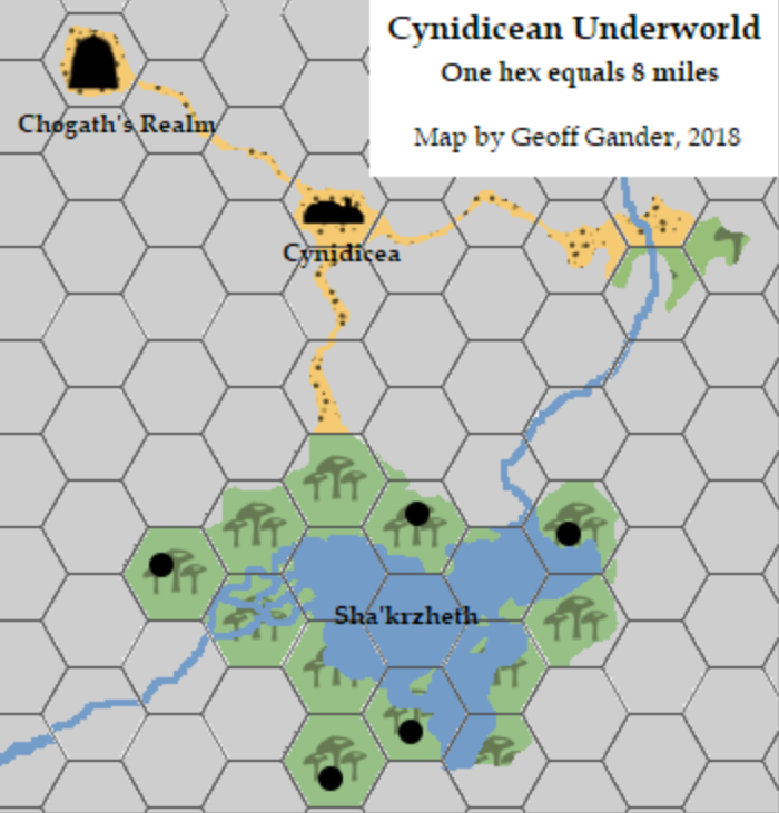
Geoff’s Cynidicean Underworld, 8 miles per hex
Although Geoff has mostly worked on collaborative projects since 2012, contributing to other people’s maps rather than producing his own, he produced one last hex map in 2018: the Cynidicean Underworld. It’s a complement to his much (much) earlier work, the Dungeon Master’s Guide to Cynidicea (2000), a community project which he worked on as editor.
The map itself is a step up from his previous underground map, with proper hex art.
Will this be Geoff’s last solo hex map? Only time will tell. What I can say for sure is that it is very far from the last hex map he has contributed to, or that he will contribute to in the future. In whatever form his next work takes, Geoff Gander has been a regular contributor to the Mystara community for 25 years and counting, and I can’t imagine that will ever change.
Thank you, Geoff!
Fan-made Map by Geoff Gander (April 2018)
This is an original map created by one of Mystara’s excellent fan cartographers. For more information on the cartographer, including a gallery of all their maps, see also Appendix M: Mappers of Mystara.
Sources
- Original work
Secondary Sources
References
- Geoff’s entry in Appendix M: Mappers of Mystara
- Geoff’s author page at the Vaults of Pandius
Map Types
The Atlas of Mystara includes a few fundamentally different types of maps. The colour of the castle wall border on each map shows which category it belongs to.
- Replica maps (white castle border) are exact replicas of primary source maps. They present the world of Mystara as the original source materials depict it, warts and all. No attempt has been made to fix errors of any kind — even typos. As far as possible, replica maps use the same art as the original maps, though in many cases they are colourised. These maps are the main source material of the Atlas of Mystara, forming the base of all of the updated maps.
- Updated maps (green castle border) present the Atlas of Mystara’s consistent view of the world, with all errors, alignment issues, and so on fixed. They use standardised hex art and fonts. Anything not marked as a replica map is an updated map.
- Chronological maps (yellow castle border) provide snapshots of Mystara at the end of a certain year in its publication history. In effect, they are updated maps created from a limited list of sources. The years in question appear in the title of each map.
- Fan-made maps are unofficial maps created by other fan cartographers. As such, they do not follow the Atlas’s castle border colour scheme. The Atlas presents these maps in their original form, with the permission of the cartographers. The Atlas considers these maps secondary sources, and updated maps of areas not covered by official maps make extensive use of them. In a few cases, the Atlas also presents Replica fan-made maps (red castle border).
Chronological Analysis
This is a fan-made map. It was published in 2018. The updated Atlas version of this map is not yet available. See also Appendix C for annual chronological snapshots of the area. For the full context of this map in Mystara’s publication history, see the upcoming Let’s Map Mystara 2018. (Please note that it may be some time before the project reaches this point.)
The following lists are from the Let’s Map Mystara project. Additions are new features, introduced in this map; Revisions are changes to previously-introduced features; Hex Art & Fonts track design elements; and finally Textual Additions are potential features found in the related text. In most cases, the Atlas adopts these textual additions into updated and chronological maps.
Coming Soon


