
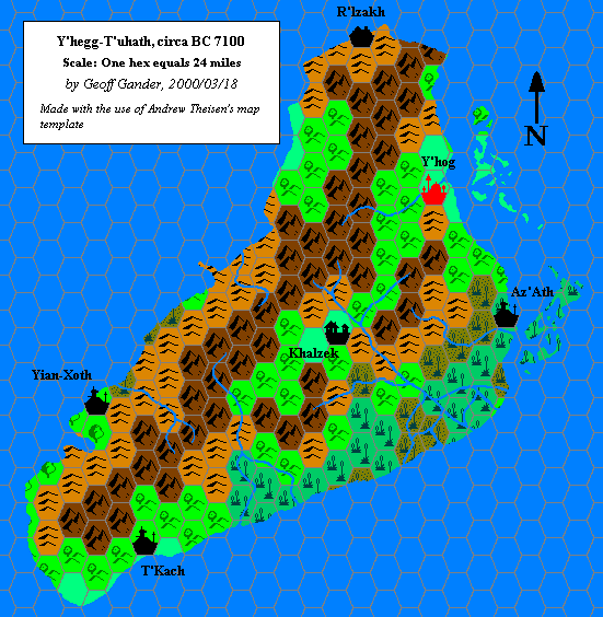
Geoff’s Y’hegg-T’uhath, 24 miles per hex
The underside of Geoff’s creation of Lhomarr was Y’hegg-T’uhath, land of the carnifex and bastion of dark worship of the Outer Beings. These works took Tom Moldvay’s carnifex from module M3 and expanded them into a whole society in the primeval world, 8,000 years before the Gazetteer era.
Map-wise, this one is the pair of Lhomarr, although separated by more than a year a half — and you can see slight tweaks to the palette, most notably in the hill hexes. While Lhomarr was an entirely original creation, for Y’hegg-T’uhath Geoff used an island from the Hollow World Set’s Precataclysmic Map that doesn’t appear on 1,000 AC-era maps. Of course the terrain itself is entirely Geoff’s invention.
This map didn’t make it to the Vaults of Pandius until 2020, although it was featured in Thibault Sarlat’s map archive for many years. Francesco Defferrari would later adapt it to a slightly different format on one of his maps of ancient Mystara.
Fan-made Map by Geoff Gander (March 2000)
This is an original map created by one of Mystara’s excellent fan cartographers. For more information on the cartographer, including a gallery of all their maps, see also Appendix M: Mappers of Mystara.
Sources
- Original work
Secondary Sources
- Carnifex Language current as of 16 December 1999 (Vaults of Pandius)
- Threshold Magazine Issue #5 (October 2014)
- Y’hog – The Blackest Port in the West (Vaults of Pandius)
References
- Geoff’s entry in Appendix M: Mappers of Mystara
- Geoff’s author page at the Vaults of Pandius
Map Types
The Atlas of Mystara includes a few fundamentally different types of maps. The colour of the castle wall border on each map shows which category it belongs to.
- Replica maps (white castle border) are exact replicas of primary source maps. They present the world of Mystara as the original source materials depict it, warts and all. No attempt has been made to fix errors of any kind — even typos. As far as possible, replica maps use the same art as the original maps, though in many cases they are colourised. These maps are the main source material of the Atlas of Mystara, forming the base of all of the updated maps.
- Updated maps (green castle border) present the Atlas of Mystara’s consistent view of the world, with all errors, alignment issues, and so on fixed. They use standardised hex art and fonts. Anything not marked as a replica map is an updated map.
- Chronological maps (yellow castle border) provide snapshots of Mystara at the end of a certain year in its publication history. In effect, they are updated maps created from a limited list of sources. The years in question appear in the title of each map.
- Fan-made maps are unofficial maps created by other fan cartographers. As such, they do not follow the Atlas’s castle border colour scheme. The Atlas presents these maps in their original form, with the permission of the cartographers. The Atlas considers these maps secondary sources, and updated maps of areas not covered by official maps make extensive use of them. In a few cases, the Atlas also presents Replica fan-made maps (red castle border).
Chronological Analysis
This is a fan-made map. It was published in 2000. The updated Atlas version of this map is not yet available. See also Appendix C for annual chronological snapshots of the area. For the full context of this map in Mystara’s publication history, see the upcoming Let’s Map Mystara 2000. (Please note that it may be some time before the project reaches this point.)
The following lists are from the Let’s Map Mystara project. Additions are new features, introduced in this map; Revisions are changes to previously-introduced features; Hex Art & Fonts track design elements; and finally Textual Additions are potential features found in the related text. In most cases, the Atlas adopts these textual additions into updated and chronological maps.
Coming Soon


