
LoZompatore’s Precataclysmic Mystara
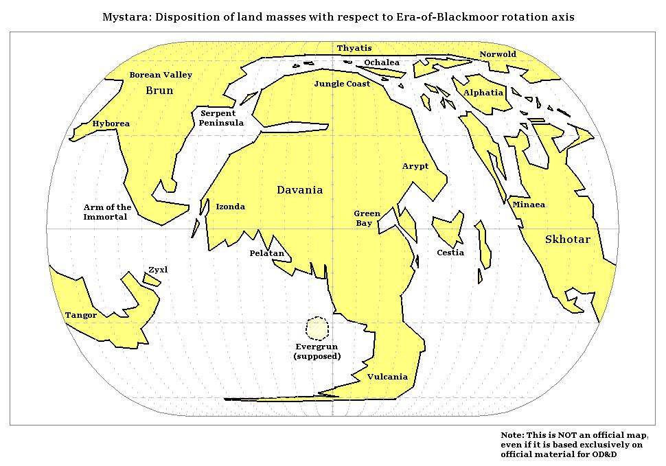
This map from mid-2005 is the primary result of Michele’s project to produce an accurate pre-Great Rain of Fire map of Mystara. It shows the configuration of pre-cataclysmic landmasses, with modern nations marked in their approximate locations to make the map easier to read.
The first step in this project involved deriving coordinates from the Hollow World Set Outer World map, as described in the post for Michele’s base map of Mystara. He then used a Visual Basic script in Excel to exectue mathematical formulas, applying a rotation to the coordinates. This simulated the shift in Mystara’s axis caused by the Great Rain of Fire.
In his post (#34) at the Wizards MMB, Michele described the parameters he chose for this map as follows:
For the axis rotation, I considered the fact that the Ethengar steppes (33N, 32W of Sundsvall Meridian) were the ancient North Pole (see the PWAs series in the description of the Ethengar Khanate). By the way: the ancient south pole is a point at 33S, 148E of Sundsvall, which is a portion of sea just west of Cape Fire on Vulcania.
It’s worth noting that the precise parameters of Mystara’s axis shift, the location of the pre-cataclysm north pole, and the location of Blackmoor all continue to be hotly contested topics within the community. Michele went into more detail on these topics later in the thread (see post 40).
As with he did with his post-cataclysm map, Michele chose the Eckert IV projection. He then used his Visual Basic script in Excel to generate the points, before joining these up and adding fills, labels, and graticule lines in MS Paint.
The resulting map is rather different from the Hollow World Set‘s Precataclysmic Map, because this one is based on data and mathematics rather than an artist’s best guess. This change reflects the direction our community’s cartographers would continue to take in the future, as it allowed us to take advantage of modern real world technologies and software in mapping out the fantasy world.
Finally, this may well have been the first map to feature a location for Evergrun. Previously, GAZ5’s Elven Migrations map had showed a label with an arrow pointing off the side of the map, but not an actual location. Michele would go on to further develop this idea in succeeding years.
Fan-made Map by Michele Carpita (August 2005)
This is an original map created by one of Mystara’s excellent fan cartographers. For more information on the cartographer, including a gallery of all their maps, see also Appendix M: Mappers of Mystara.
Sources
- Hollow World Campaign Set (1990) (PDF at DriveThruRPG)
- Outer World Planetary Map
- Outer World Precataclysmic Map
Fan Sources
- LoZompatore’s Mystara (August 2005)
- Blackmoor and the Broken Lands thread at the MMB, preserved at the Vaults of Pandius (October 2005)
- Blackmoor and Pre-Cataclysmic Mystara at the Vaults of Pandius (October 2005)
References
- All of Michele’s maps at the Atlas of Mystara
- Michele’s entry in Appendix M: Mappers of Mystara (upcoming)
- Michele’s author page at the Vaults of Pandius
Chronological Analysis
This is a fan-made map. It was published in August 2005. The updated Atlas version of this map is not yet available. See also Appendix C for annual chronological snapshots of the area. For the full context of this map in Mystara’s publication history, see the upcoming Let’s Map Mystara 2005.
The following lists are from the Let’s Map Mystara project. Additions are new features, introduced in this map. Revisions are changes to previously-introduced features. Hex Art & Fonts track design elements. Finally, Textual Additions are potential features found in the related text. In most cases, the Atlas adopts these textual additions into updated and chronological maps.
Under Construction! Please check back again soon for updates.
Additions
- XXX —
Revisions
- XXX —
Hex Art & Fonts
- Hex Art —
- Fonts —


