
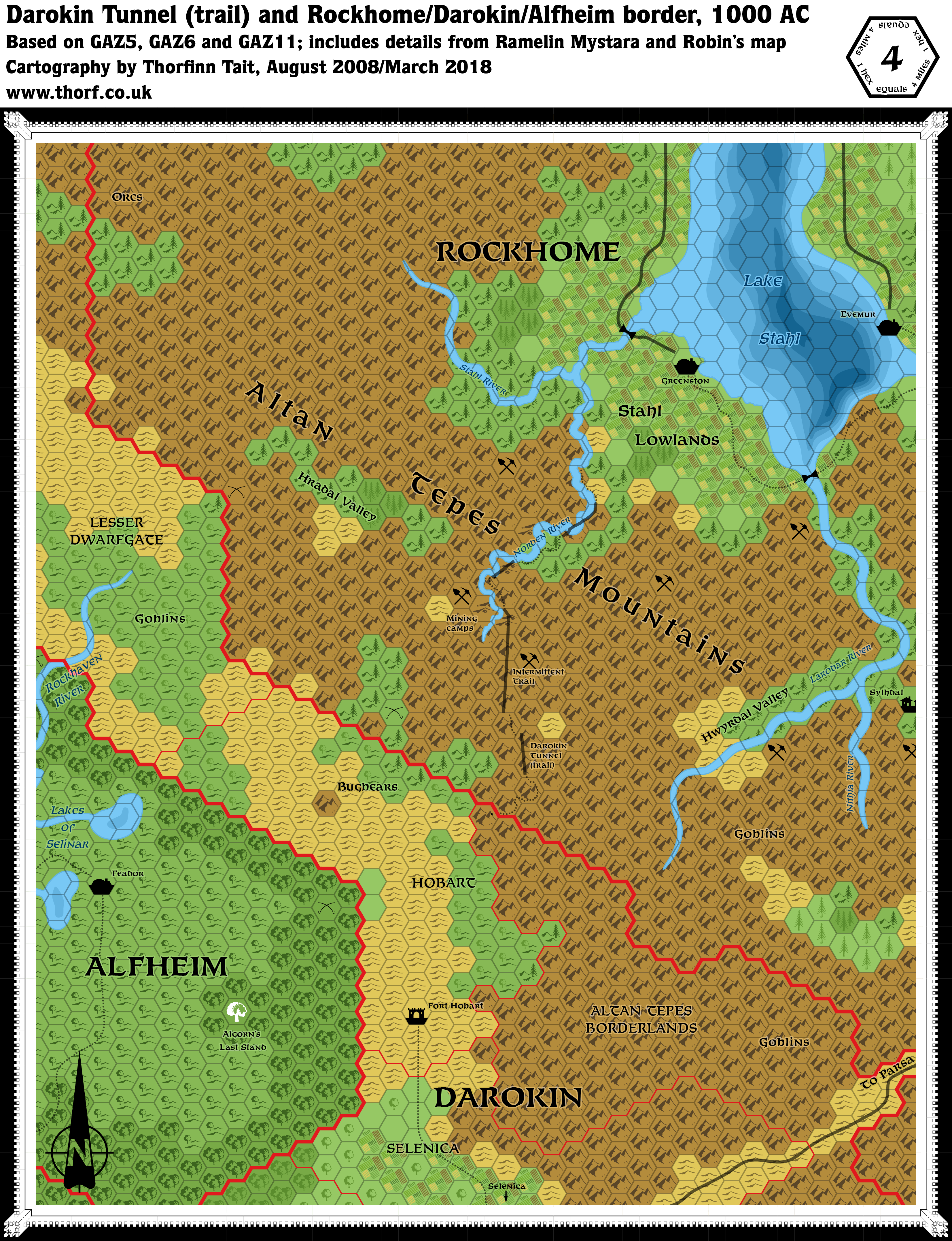
Darokin Tunnel (trail), 4 miles per hex
This is a game trail and pass through the Altan Tepe Mountains and into Darokin. The pass, which is not known to the humans of Darokin, is often used by adventuresome young dwarves for quick raids into the Alfheim forests. The trail ends at the northeastern base of a small mountain, and travellers must make a difficult climb over this mountain to reach the foothills of Darokin.
from GAZ6 The Dwarves of Rockhome, by Aaron Allston
Map (March 2018)
Sources
- GAZ6 The Dwarves of Rockhome (1988) (PDF at DriveThruRPG)
- Detail of the Darokin Tunnel (trail), page 82
- Poster map of Rockhome
- GAZ5 The Elves of Alfheim (1988) (PDF at DriveThruRPG)
- GAZ11 The Republic of Darokin (1989) (PDF at DriveThruRPG)
Fan Sources
- Ramelin Mystara Rockhome, 8 miles per hex
- Robin’s Darokin Tunnel, 1 mile per hex
Comments
The original map in GAZ6 was rotated 60º, making it a very peculiar map indeed. This updated map restores the normal “north up” orientation, expanding out to cover the area of the Rockhome/Darokin/Alfheim border.
Reference was made to Robin Dijkema’s 1 mile per hex map, although most of the details from that map are too fine to be shown at this scale. I also incorporated various details from Ramelin Mystara Rockhome, as detailed in the notes below. Ignacio Ramos’s notes state that “Villages, Geographical features and other labels have been “invented” using the dwarvish dictionary from GAZ6”, which seems entirely appropriate.
Notes
- Evemur — GAZ6 page 55 says that Evemur is “built on the lakeshore (the city name means “Highlake” in the dwarven tongue), less than a mile from where the mountains begin sloping steeply upwards.” Therefore it has been moved to the shore of the lake, with a forested hills hex behind it representing the beginnings of the mountain slopes behind it.
- Hradal Valley — from Ramelin Mystara. Translates as “Green Valley”, according to GAZ6’s Dwarf Language list (pages 28-29).
- Hwyrdal Valley — from Ramelin Mystara. Translates as “Valley of the Wind”, according to GAZ6’s Dwarf Language list (pages 28-29).
- Lake Stahl — added depths for this lake, which is described in GAZ6 as being very deep.
- Mines — GAZ6’s map neglected to show any mines. This map adds various mines, albeit without labels; these are taken from the secondary source maps.
- Stahl Lowlands — GAZ6 page 6 refers to this area as “a fertile lowland territory where two-thirds of Rockhome’s agricultural needs are grown”.
- Sythdal — from Ramelin Mystara. Translates as “Quiet Valley”, according to GAZ6’s Dwarf Language list (pages 28-29).
- Villages — although the map shows no villages at all, the text very much supports their addition (GAZ6 page 6c): “Not named on this map, but an important part of Rockhome, are the hundreds of small villages, particularly farming villages in the lowlands and mining villages dotting the Altan Tepe and Makkres Mountain ranges. Some are above-ground, but the majority are underground settlements, some established in existing caverns and others dug from the living rock.”
References
- Rockhome at the Vaults of Pandius
- Rockhome map thread at The Piazza
- Klintest has three outflows — discussion thread at The Piazza
Thanks to:
Robin Dijkema, Kheldren, Joe Mason (JoeNotCharles), Mike, Sheldon Morris (Hugin), Satyros, Andrew Theisen (Cthulhudrew)
")
")
")
10 March 2018 @ 10:28 pm
Hi Torf
Nice…you used my Tunnel Map.;)
nice map..and indeed the awkwardness of the 60 degeee tilt was something to get used too, especially in the 1 mile elargement of the hex scale size.
asa to naming variations; the names you use here I assume to be just the Dwarven Names… the ones I used then, I assume to be Thyatian/Darokinian…for example the Hradal Valley and the ‘hidden crystal valley’ are the same.
one question though…
You placed several depth lines within the lake…no problem, actually great, but what depth is each color?
11 March 2018 @ 2:01 am
Hi Robin!
Yes, I wanted to stick to just dwarven names as much as possible. I realise that there are humans here, too, but I think mixing the place names too much spoils the theme — it’s my primary regret about Wendar, actually, that we went too far in dividing up the land into immigrant cultures. My preference is for local names, with a maximum of one or two names from the incoming culture(s).
In any case, I was thinking about the depths as I drew them in, and decided to let the community decide. The model for Lake Klintest is presumably Loch Ness, which is about 300 m deep in the deepest parts. So I was sort of thinking 50 m per division. Though of course Mystara tends to work in feet.
What do you think?
I held off on adding too much extra stuff — your map already shows all the fine details, so there’s no need to try to cram them in.