Thanegioth Archipelago Project
A recreation of the Wizards of the Coast Mystara Message Board thread, with restored links and images.

Apr 09, 2006 11:20:48
|
|
|
Thorf - for the fauna I generally go for only sentient creatures, so Araneas, and Troglodytes are in, Rock Baboons and Squid are out.
Also, looking at the map from Dungeon 114, only one label seems to fit with the previous labelling (The Fangs of Zotzilaha, though I may change the "The Fangs of" bit, sounds like a possible English translation of the local name though). The rest of them sound a bit "comedy pirate" to me though, I mean "Scurvy Reef" "Skinrazer Rock". Others do sound as possible translations of the local versions. Don't really have time to come up with ideas atm, but will try and sit down at some point. Unless anyone else can get there first.
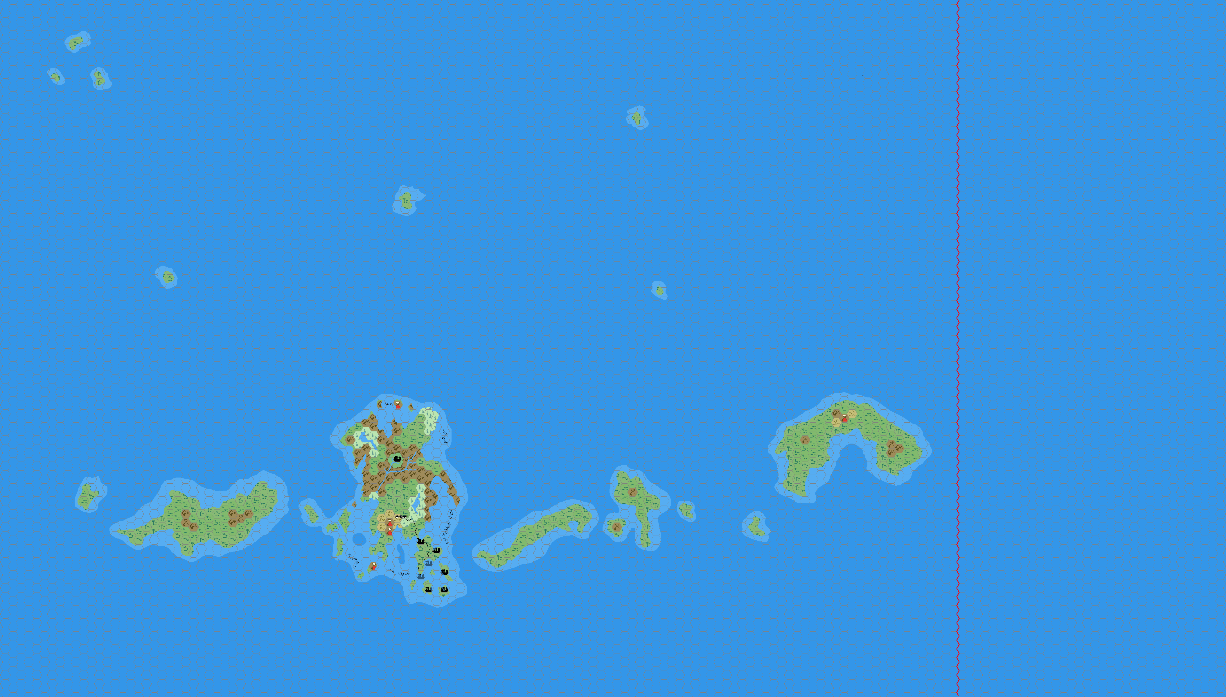
[Edit] Uploaded an unlabelled version of just the Sea of Dread area in 8 mph here . Any suggestions / corrections please let me know. (And I will be updating one hex to jungle caves as per Thorf's map, but I can't do that on this PC)
|
Apr 09, 2006 12:47:40
|
 |
|
|
Join Date: Jan 2005
Location: Akita, Japan
|
|

Quote:
|
Thorf - for the fauna I generally go for only sentient creatures, so Areanas, and Troglodytes are in, Rock Baboons and Squid are out.
|
That sounds like a good rule. On the current version of my map, all I did was change all the numerical map labels into actual labels, including many that I consider to be largely unnecessary. When I revise it with new names and stuff, I will trim out all but the most useful of those labels, I think.
Quote:
|
Also, looking at the map from Dungeon 114, only one label seems to fit with the previous labelling (The Fangs of Zotzilaha, though I may change the "The Fangs of" bit, sounds like a possible English translation of the local name though). The rest of them sound a bit "comedy pirate" to me though, I mean "Scurvy Reef" "Skinrazer Rock". Others do sound as possible translations of the local versions. Don't really have time to come up with ideas atm, but will try and sit down at some point. Unless anyone else can get there first.
|
Hehe, on the contrary I found "The Fangs of Zotzilaha" to be the worst of the new labels. What's with the Aztec-style name? The villages sound more polynesian to me...
But yes, I agree with you. The names given on that map were almost all a bit too tacky for my liking. It would be nice to get more of a native feel to them, as opposed to the imperialistic/explorer names given on that map.
Still, perhaps we can use them as a basis for the native names, perhaps by translating them into another language - Maori, for example.
Quote:
[Edit] Uploaded an unlabelled version of just the Sea of Dread area in 8 mph here . Any suggestions / corrections please let me know. (And I will be updating one hex to jungle caves as per Thorf's map, but I can't do that on this PC) |
Very nice! I can't help but feel that the Isle of Dread is one or two hexes too low, but perhaps that is just due to the added islands around the southeastern peninsula. I do have a few suggestions, though: add some rivers, perhaps one or two to each island; a swamp or two; some more broken lands, perhaps around the extinct volcanoes; lots more small islands, of similar size, quantity and distribution to those around the Isle of Dread.
Also, mountains on some of the coasts (i.e. cliffs), and sandy beaches on others. Not to mention reefs scattered liberally around the whole archipelago.
Then of course we get into the discussion of other villages, ruins, and so on. My view of the archipelago is of a land rich with opportunities for adventure, but in a tropical wilderness setting, without the proximity of civilisation to back up the party. Therefore it should include villages and camps, both friendly and dangerous; ancient ruins to be explored; exotic monsters to fight; mountains to climb; and caves to investigate. |
Apr 10, 2006 14:57:30
|
|
|
I've uploaded a new version (still unlabelled, but I'll get to that later). I'm thinking about having the island to the west of the Isle of Dread populated by a tribe of savage halflings. The decendants of some who got blown off course when they moved from Davania to Brun. Imagine the PCs faces when those cute halflings with grass skirts tie them to spits over a fire.
As for naming, the online Maori - English dictionaries are so-so, will try and look up a Polynesian one tomorrow.
|
Apr 10, 2006 16:25:01
|
 |
|
|
Join Date: Apr 2004
Location: Long Beach, CA
|
|
Quote:
|
I've uploaded a new version (still unlabelled, but I'll get to that later). I'm thinking about having the island to the west of the Isle of Dread populated by a tribe of savage halflings. The decendants of some who got blown off course when they moved from Davania to Brun. Imagine the PCs faces when those cute halflings with grass skirts tie them to spits over a fire.
|
On the western Island- I had hypothesized making it the location of legendary Vacros and Cathos eons ago, and made up this preliminary map. I never really went with it, due to the nature of Cathos (a city) seeming a bit at odds with the otherwise "primitive" feel of the Thanegioth Archipelago. Plus, these days, I think the names and themes of the region as described in MSOLO: Maze of the Riddling Minotaur fit in better with the Minaean/Bellisarian region, so I am inclined to place Cathos and Vacros there.
You might find some interest in the map as a reference, though (although I hadn't noticed the scale discrepancies with the IoD before, so I don't know offhand if the other islands in the TA will have the same problems- probably not, since they only appeared on larger scale maps, but it's something to bear in mind).
As for primitive halflings, in a story that Geoff and I were alternating chapters of eons ago ( A New Twist on an Old Adversary)- though I dropped the ball and the story just kind of died; we were going to change the name, too, though I don't recall to what-
Anyway, in my next installment, I was going to introduce a character who was going to be a halfling from Davania- a black (or dark-skinned, anyway) halfling- who was a descendant of the tribes that still live down there and didn't emigrate north (where the pale-skinned ones now live). They weren't going to be primitive, but they were going to retain a more tribal, nomadic culture. Maybe your Thanegioth halflings are related to them, or they could just be as you say- descendants of castaways from the original migration. |
Apr 10, 2006 16:27:01
|
 |
|
|
Join Date: Mar 2004
Location: Ontario, Canada
|
|
Quote:
|
I'm thinking about having the island to the west of the Isle of Dread populated by a tribe of savage halflings. The decendants of some who got blown off course when they moved from Davania to Brun. Imagine the PCs faces when those cute halflings with grass skirts tie them to spits over a fire.
|
That's awesome! lol
I honestly would love to get my players there just to see the looks on their faces! What about Immortal-worship for them? Maybe they revere something other than an Immortal. Interesting... |
Apr 11, 2006 18:05:18
|
|
|
Quote:
|
I honestly would love to get my players there just to see the looks on their faces! What about Immortal-worship for them? Maybe they revere something other than an Immortal. Interesting...
|
Probably some Entropic volcano/fire Immortal, or maybe an evil Energy Immortal. Not sure who that would fit. Generally I use Thanatos for evil, twisted things like this as he delights in corrupting innocents. |
Apr 12, 2006 13:08:03
|
|
|
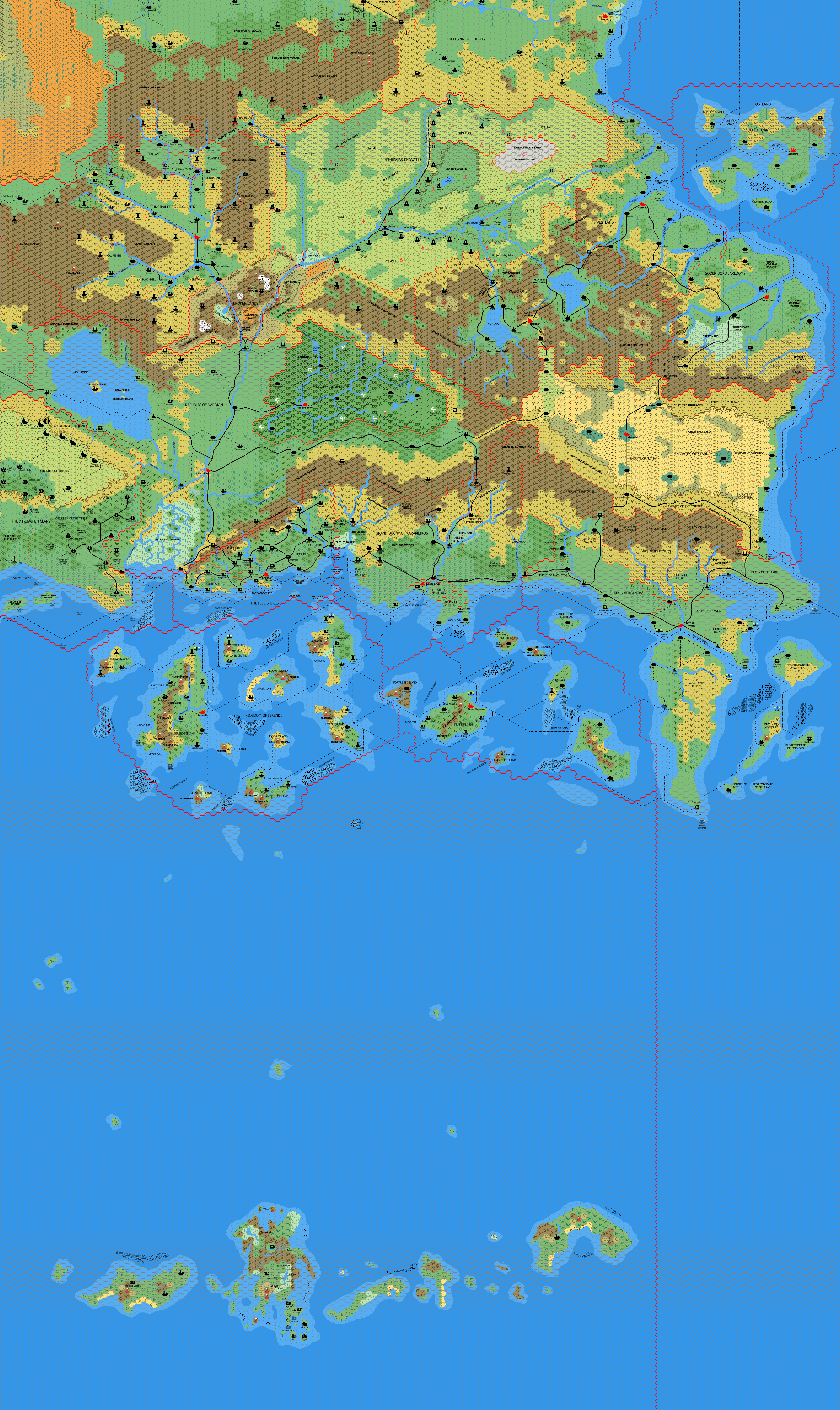
Have merged the Sea of Dread map with my one of the Known World (available here ). I've also updated the Atruaghin Clans and Wendar regions with Thorf's maps.
The Sea of Dread region is still largely unlabelled as I just don't seem to have any inspiration at the moment.
Thorf - it does appear lower on this map, due to the additional islands below which seem to have been dropped from the regional map in X1 (imo).
 |
Apr 12, 2006 13:23:06
|
|
|
|
Join Date: Mar 2004
Location: Ontario, Canada
|
|
Quote:
|
Have merged the Sea of Dread map with my one of the Known World
|
Cool. It's interesting to see all those maps combined into one like that. Good job. |
Apr 12, 2006 13:24:02
|
|
|
|
Join Date: Jan 2005
Location: Akita, Japan
|
|
Quote:
Have merged the Sea of Dread map with my one of the Known World (available here ). I'm not able to post it directly into the board as it is about 3MB and I'm not sure what the bandwidth on my site is. I've also updated the Atruaghin Clans and Wendar regions with Thorf's maps.
The Sea of Dread region is still largely unlabelled as I just don't seem to have any inspiration at the moment.
Thorf - it does appear lower on this map, due to the additional islands below which seem to have been dropped from the regional map in X1 (imo). |
Looking very nice! Your additions are starting to make the chain look much more interesting. I especially like your reef placement - great work.
You could still add in a small inland lake to one of the larger islands, and perhaps a river on one or two islands too. Also, I'd still like to see a lot of smaller islands scattered throughout the archipelago, filling in some of the empty spaces between the larger islands. Of course, they should all be the same size or smaller than the smallest islands shown on the 24 mi per hex map.
Have you considered marking on deeper water, or are you intending to stick to the current two shades? The official maps go as far as having four shades, which I have been wrestling with for some time now. |
Apr 12, 2006 13:52:07
|
|
|
Quote:
|
Have you considered marking on deeper water, or are you intending to stick to the current two shades? The official maps go as far as having four shades, which I have been wrestling with for some time now.
|
I decided a long time ago to reserve the differing undersea levels for maps of the undersea region. I just feel that it's not relevant to know below about 10 fathoms or so when conducting a surface based adventure.
[Edit]
Map updated with a couple of smaller islands.
I also removed the Rakasta camp, and placed a generic Rakasta marker, as from the description in X1 it sounded like a temporary hunting camp, rather than a more formal military/permanant camp. |
Apr 12, 2006 16:16:16
|
 |
|
|
Join Date: Feb 2006
Location: Rome, Italy
|
|
I like your map very much, mah9.
I suggest you to writhe some island name in Thanegiot as you did in Ierendi and Minrothad.
More: I see you forgot Ranwood label in Soderfjord Jarldoms, between Lande(r)sfjord River and (north of) Overland Trade Route.
|
Apr 12, 2006 17:56:46
|
|
|
Quote:
|
I like your map very much, mah9.
I suggest you to writhe some island name in Thanegiot as you did in Ierendi and Minrothad.
More: I see you forgot Ranwood label in Soderfjord Jarldoms, between Lande(r)sfjord River and (north of) Overland Trade Route.
|
The island names from Ierendi and Minrothad are from the respective Gazetteers and the Trail Maps, wheras I have no canon names for the Thanegioth Archepeligo apart from "The Isle of Dread" which doesn't seem to me to be a "local" name, rather one from Thyatian or other "Explorers". I'm not that good at names, so I'm hoping the kind people here will help me with that.
And the Ranwood label has been added. |
Apr 13, 2006 12:27:06
|
|
|
|
Join Date: Jan 2005
Location: Akita, Japan
|
|
I just finished doing the Central Plateau maps from X1, and when I compared the plateau on those maps to the Isle of Dread map, I found yet another discrepancy: the scale is out again.
Once again, the large scale map has a scale that makes the plateau much bigger than the smaller scale maps would indicate. The Central Plateau is about 28 miles across, while the same plateau on the Isle of Dread map is only about 20 miles across. (The cartographers who worked on X1 seem to have put an in-built tardis effect into these maps...)
We can work out the correct scale, though. One hex on the 6 mi per hex map should be equal to 8 hexes on the Central Plateau map, meaning that the correct scale should have been 3/4 mi per hex. These calculations are based on taking the Isle of Dread's 6 mi per hex scale as correct.
But of course we know that it is also wrong, and my new updated map has a more reasonable 4 mi per hex scale. This seems to go better with the Central Plateau, because it means we can relabel it at 1/2 mi per hex, which is a much more normal scale.
So, to sum up, if you want to use the X1 maps as is, please consider them to be at the following scales:
- Known World and Sea of Dread map: 24 mi per hex
- Isle of Dread map: 4 mi per hex
- Central Plateau map: 1/2 mi per hex
This new set of scales makes all the maps fit together much better. |
Apr 13, 2006 13:31:10
|
|
|
|
Join Date: Apr 2004
Location: Long Beach, CA
|
|
I'm surprised changing the scale of the IoD map the way you did the first time didn't correct the problem (although I suppose it's simply a matter of someone just drawing the plateau wrong on the larger scale map, and not referencing the two).
In any case, I'd be inclined, for a feature like that, to disregard the larger scale map, and stick with the smaller scale (which is more detailed). Something along the lines of other features that alter with scale- ie, you lose the detail of grassland hexes and things that are near mountain hexes and such.
Then again, considering that I didn't like the way they disregarded the actual size of the Atruaghin Plateau on the large scale maps and came out with a much smaller version for the Gaz, maybe I should reconsider that opinion. Guess it has to do with chicken and egg mentality- the large scale plateau for the Clans is the one the smaller map should have been based on (it came first), while the small scale plateau on the IoD is the one the larger map should have been based on for the same reason.
|
Apr 13, 2006 14:12:00
|
|
|
|
Join Date: Jan 2005
Location: Akita, Japan
|
|
I think you have large scale and small scale mixed up. Large scale means small area, lots of detail, for example 1:5000. Small scale means large area, not so much detail, for example 1:50,000. The way I remember it (when I do remember it - I seem to forget which is which every few weeks :embarrass ) is that 1/5000 is larger than 1/50,000.
Anyway, I largely agree with what you are saying. It's a good general rule to say that smaller scale maps provide more detail and are thus better sources than larger scale maps. But unfortunately it's not always that simple, and there are times when we can't rely on the most detailed maps as the best source.
In the case of the Gazetteer maps, they outrank the Known World overview maps not only because they show more detail, but because they show detail that wasn't there before. They clarify and expand on the original sources. Plus of course they were made later. So clearly they are the best sources to use as a foundation.
Then we come to the modules. Most of these were made before the Gazetteers came out. Yes, their maps have lots of interesting details, but they are outranked chronologically by the Gazetteer maps - which themselves seem to have been made without reference to the module maps. We definitely want to use these details, but sometimes the changes they demand of the Gazetteer maps is just too much.
In those cases (X13 and B10 come to mind), we just have to make a judgement call on what to keep as is, what to adapt, and what to throw away.
The Atruaghin Plateau is a bit of a different matter, because we can safely say that GAZ14's large scale (8 mi per hex) map was a mistake - possibly deliberate (to fit the poster map), but a mistake nonetheless. The other sources are just too numerous to accept the change. But most of all, it is an undesirable change, so we have no need to accept it.
With X1, on the other hand, we are talking about a single source that spawned three maps, all of which present different scales that conflict with the other two maps. Usually in this case we would start from the largest scale map and work outwards. That would give us two options: rescale the Isle of Dread and Known World maps, or redraw the plateau bigger on the other maps.
Rescaling means changing the labels of 1/6/24 to 1/8/48, which of course is ludicrous, because the Known World map's scale of 24 mi per hex is set in stone. Even if we just apply that scale to the Isle of Dread itself, it would be a bit silly, because we would have to double the size of the Isle on the Sea of Dread map.
Redrawing the plateau is a valid option, but in doing so we are introducing a complex change to the Isle of Dread map, which of course has its own problems of scale to deal with. Also, we would be "overwriting" the land around the plateau - in this case just mountains.
On the other hand, rescaling from the small scale map down allows us to keep all three maps pretty much as-is; we don't lose any detail, we just make things a bit smaller. Then we can follow the standard convention of revising the smaller scale maps using the larger scale maps: redraw the plateau on the Isle of Dread, possibly adding the crater, the lake and the rivers, then redrawing the Isle of Dread on the Known World/Sea of Dread map, by revising the coastline, tweaking terrain, etc.
In the end, I think the simple rescaling is the best option, because it allows the official maps to be salvaged and remain usable. Does it really matter that the plateau is now 14 miles across instead of 28?
(Sorry, that got a bit longer than I intended...) |
Apr 13, 2006 14:28:20
|
|
|
|
Join Date: Apr 2004
Location: Long Beach, CA
|
|
Quote:
I think you have large scale and small scale mixed up. Large scale means small area, lots of detail, for example 1:5000. Small scale means large area, not so much detail, for example 1:50,000. The way I remember it (when I do remember it - I seem to forget which is which every few weeks :embarrass ) is that 1/5000 is larger than 1/50,000. |
Whoops! I always just assume that large means "big area" and small means "small area."
Quote:
|
In the end, I think the simple rescaling is the best option, because it allows the official maps to be salvaged and remain usable. Does it really matter that the plateau is now 14 miles across instead of 28?
|
Probably, to the people that live on it. 
I'd have to check the maps to really be sure what you're talking about in terms of scale of the plateau, though. In your OP, when you said:
Quote:
|
I just finished doing the Central Plateau maps from X1, and when I compared the plateau on those maps to the Isle of Dread map, I found yet another discrepancy: the scale is out again.
|
(Italics mine for emphasis)
Do you mean the Isle of Dread map from X1 itself, or just the Central Plateau maps from X1 compared to another source. That is the source of my confusion. If the two maps within the same product differ in scale, then I'd agree to go with the smaller scale map (not my definition of smaller scale  ), and rescale the larger scale map.
If you are comparing sources from two different products, I'd be inclined to go with the original source in this case. |
Apr 13, 2006 14:42:47
|
|
|
|
Join Date: Jan 2005
Location: Akita, Japan
|
|
All three maps are from X1, yes. The three maps in question are the Known World and Sea of Dread map, 24 mi per hex; the Isle of Dread map, 6 mi per hex; and the Central Plateau map, 1 mi per hex.
Unfortunately, the relative scales are definitely not 24:6:1. If the scales are taken as is, two of the maps would have to be extensively redrawn. Hence my proposal to rescale the maps. The actual ratio of the things depicted on the maps is more like 24:4:1/2, (or 48:8:1, or 36:6:3/4, depending on which map you choose as a reference).
Regarding the size of the plateau, and indeed the island, I don't think changing the scales from 6 to 4 mi per hex and from 1 to 1/2 mi per hex will significantly affect the adventure. Remember that all that changes is the "real" size of things, and therefore the most significant effect will be travel time.
|
Apr 13, 2006 17:04:39
|
|
|
Quote:
|
Remember that all that changes is the "real" size of things, and therefore the most significant effect will be travel time.
|
And you can always introduce a magical reason for slowing down the rate of travel if you so wish, to return the journey times to the original. |
Apr 13, 2006 20:20:39
|
|
|
|
Join Date: Jan 2005
Location: Akita, Japan
|
|
Quote:
|
And you can always introduce a magical reason for slowing down the rate of travel if you so wish, to return the journey times to the original.
|
Yeah... Or you could even just make a ruling that all travel times are increased by one third due to difficult wilderness terrain. It is all unspoilt jungle, after all. 
On the plateau, all travel times need to be doubled, though, and it's mostly clear terrain. Hmm... |
Apr 14, 2006 2:40:01
|
|
|
Quote:
|
On the plateau, all travel times need to be doubled, though, and it's mostly clear terrain. Hmm...
|
An artifact buried under the ruined temple. Where the priests would have had amulets to make them immune to the effects, but it stops the sacrifices from running away so fast? |
Apr 14, 2006 10:24:05
|
|
|
|
Join Date: Apr 2004
Location: Long Beach, CA
|
|
Quote:
|
An artifact buried under the ruined temple. Where the priests would have had amulets to make them immune to the effects, but it stops the sacrifices from running away so fast?
|
An idea that I never actually expanded upon for the Mystara community, but which I use IMC, is that the Kopru Empire that is referred to in X1 was actually the Kopru Chronarchy- several empires of Kopru throughout Mystaran history, linked only by the time-traveling artifact that the Kopru used to maintain it. The story of their downfall is linked directly to their violations of time, and Immortal complicity in rectifying their abuses. Your "slow-time" artifact would definitely tie in. |
Apr 14, 2006 12:02:57
|
|
|
|
Join Date: Feb 2006
Location: Rome, Italy
|
|
Kopru Chronarchy?
Sounds good! Very good!
Do you have any material to expand it?
I really would like something to characterize more koprus.
Slizzark, the (time) lurker would be very nice. I always asked myself how being lurker would be linked to magic resistance.
It could be the resistance of being turned back in one own's time... magically, of course, becoming a general magic resistance...
Nice, very nice...
Pls, share all your ideas about time traveling koprus!
|
Apr 14, 2006 12:22:05
|
|
|
|
Join Date: Apr 2004
Location: Long Beach, CA
|
|
Quote:
|
Pls, share all your ideas about time traveling koprus!
|
IIRC, I had planned to tie Slizzark in with things.
As for more specifics, I hadn't gotten around to expanding too much more. The basic idea was that the Kopru were a race distantly related to the Carnifex (they evolved from the same distant ancestor, but the Kopru remained marine-bound, while the Carnies went onto dry land), and they were contemporaries with the Carnifex. The Carnies dominated the land, the Kopru the seas, and the two races grudgingly worked together.
When the Carnifex decided to expand to the northern continent, they initially worked with the Kopru (whose oceanic dominion they would have to cross), and the two groups entered the Serpent Peninsula. There, the kopru with their troglodyte servants (provided by the Carnifex) began to settle and create a colony.
All kinds of things happen to this colony, but the relevant portions are that one faction of the Kopru discover the time-traveling artifact that is buried under the Serpent Peninsula (the one later used by Yav), and figure out how to operate it. They disappear into the time stream, to set up their own dominions in distant futures, far from the interference of the Carnifex and other kopru. Among these dominions of the Chronarchy is the settlement in the Isle of Dread region (which is later destroyed during the Aquapopulous Wars referred to in XSolo: Lathan's Gold).
(As for the original kopru empire (in the westernmost regions of the Sea of Dread, near to the Savage Coast)- they were destroyed in a rebellion by their undersea servants shortly before the final fall of Y'Hog, c. 7,200 BC.) |
|
|