
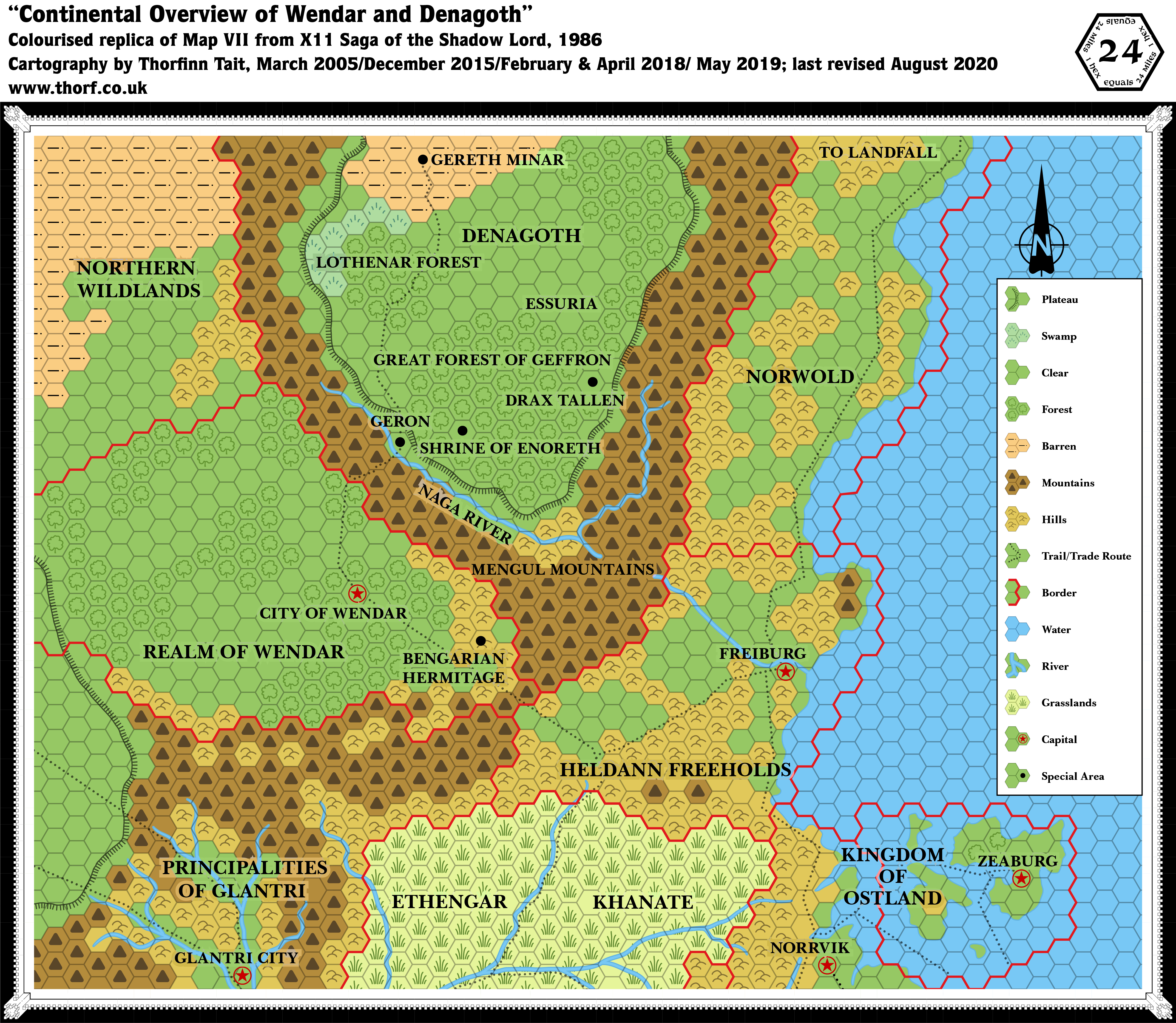
X11 Wendar & Denagoth, 24 miles per hex
X11 introduced two new nations on the borders of the Known World: Wendar and Denagoth. It also provided a first cursory look at Heldann, which was always rather neglected. However, the Norwold portion of the map is extremely problematic. To make matters worse, CM1’s Norwold had already provided a different view of this region, albeit without Heldann. These issues came to be known as the Norwold conundrum — an infamous problem area among Mystara’s cartographers.
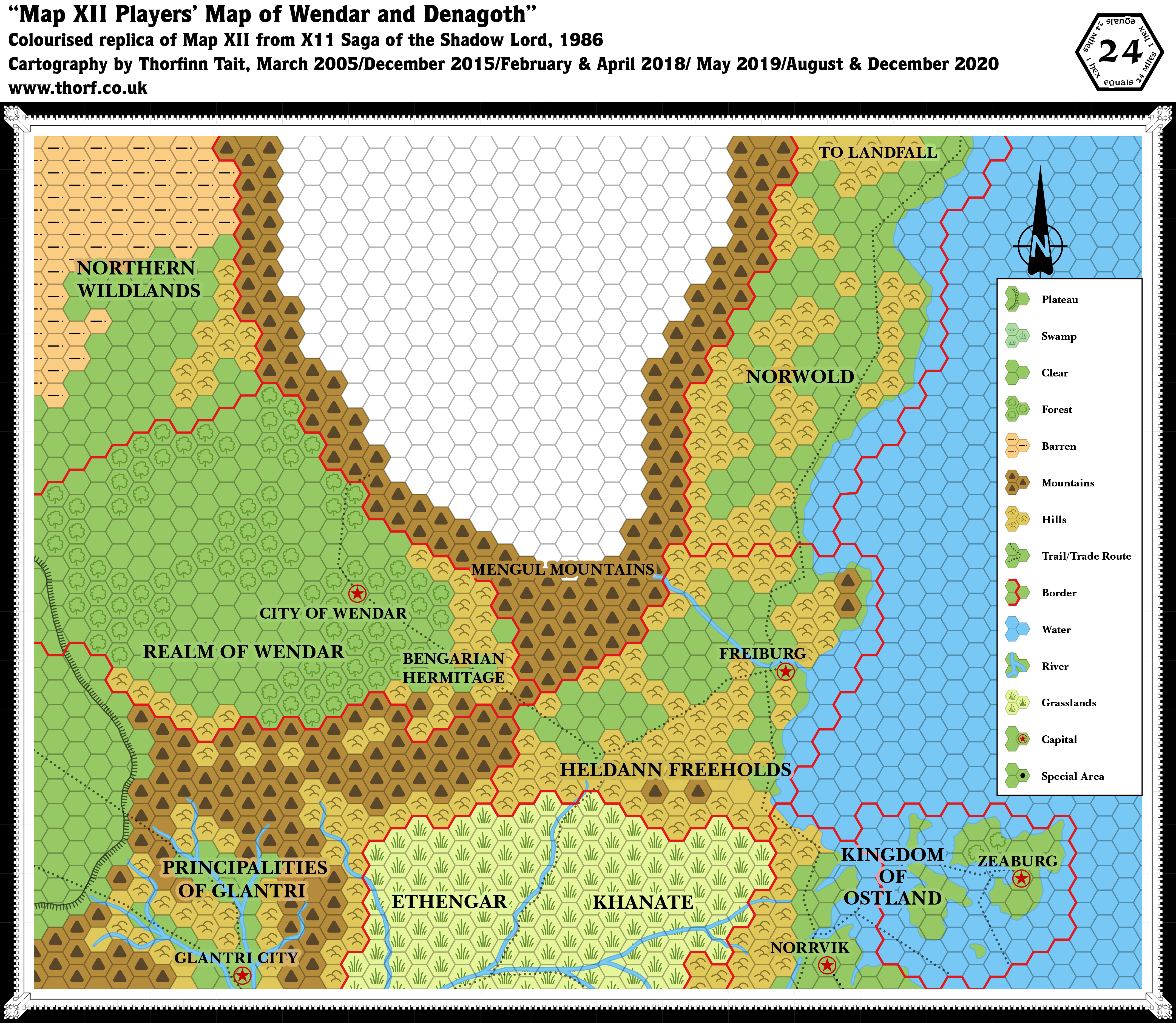
Replica Map (August 2020)
Replica Map (December 2020)
Sources
- X11 Saga of the Shadow Lord (1986) (PDF at DriveThruRPG)
- “Map VIII Continental Overview of Wendar and Denagoth”, page 32 (Cartography by Dennis Kauth)
- “Map XII Players’ Map of Wendar and Denagoth”, page 63 (Cartography by Dennis Kauth)
Chronological Analysis
This is Map 49. It was published in August 1986. The updated version of this map has not yet been released. See also Appendix C for annual chronological snapshots of the area. For the full context of this map in Mystara’s publication history, see Let’s Map Mystara 1986.
The following lists are from the Let’s Map Mystara project. Additions are new features, introduced in this map. Revisions are changes to previously-introduced features. Hex Art & Fonts track design elements. Finally, Textual Additions are potential features found in the related text. In most cases, the Atlas adopts these textual additions into updated and chronological maps.
Additions
- Borders — All of Wendar’s borders; northern borders for Glantri and Heldann, building on their southern edges as shown on previous maps; borders for Denagoth and southern Norwold.
- Mountains — The Mengul Mountains surrounding the Denagothian plateau.
- Mountain Passes — Although marked by trails rather than a special symbol, there is seemingly a pass leading up onto the plateau from Geron, and another between Heldann and Wendar.
- Nations — Wendar and Denagoth.
- Plateaus — The Denagothian plateau. It is unnamed on this map.
- Rivers — The Naga River. The river has a break as it passes through the Mengul Mountains towards Freiburg and the sea; it’s not entirely clear if this is by design, or simply to avoid obscuring the label for the mountains. Either way, it seems unquestionably the same river.
- Settlements — The City of Wendar and Freiburg, capitals of their respective nations. All other icons on the map are marked “Special Area”: Bengarian Hermitage in Wendar; Geron, Shrine of Enoreth, Drax Tallen, and Gereth Minar in Denagoth.
- Terrain — Most of Wendar, all of Denagoth, and the Northern Wildlands are all new. Denagoth includes the Great Forest of Geffron, the Lothenar Forest, and Essuria. It’s not entirely clear what the last of these represents, but the size of the font suggests it’s subordinate to Denagoth.
- Trails & Roads — The trails leading north from Ethengar and Norrvik (from Expert 1983) have been extended. From Ethengar, the trail leads north into Heldann before splitting, with the eastern trail leading to Freiburg, while the western trail leads first into Wendar, then through its capital, before turning northwards to Geron and on up onto the Denagothian plateau, where it skirts the forest of Geffron, goes through Lothenar, and finally terminates at Gereth Minar. The Norrvik trail leads straight to Freiburg, meeting the Ethengar-Freiburg trail just west of the city. Finally, a new trail follows the coast north of Freiburg all the way to the edge of the map, ostensibly leading to Landfall.
Revisions
- Borders — Although the borders for Heldann and Norwold are shown here for the first time as red lined borders, in fact CM1 included an area definition of Norwold’s border, and the Heldann-Norwold border given here contradicts that. Specifically, where X11 has the border extending from the mountainous peninsula inland to the “Mengul Mountains” label, CM1 had it at a 45º angle to this, from the peninsula to the border near Drax Tallen.
- Coastline — The entire coastline north of Freiburg is completely different. See Errors below.
- Errors — Two rather egregious errors beset this map.
- There is an error in transcription, with a column of hexes missed out in Ethengar, pulling eastern Ethengar and the Northern Reaches out of sync. The missing column is the one directly south of the hex between Heldann’s twin mountains. Revisions due to this error have not been included in this list.
- Norwold as depicted on this map is completely at odds with all previous maps of the area. Landfall should appear on this map, approximately four hexes south of the “OL” of “Norwold”.
- Terrain — See “Errors”.
Hex Art & Fonts
- Fonts — Baskerville.
- Revised Symbols — Swamp (grass strokes with a line underneath; in other maps, including other X11 maps, swamps are represented by a semicircular arrangement of five short grass strokes).
Textual Additions (X11 1986)
- Government — Wendar is a monarchy ruled by a Wizard-King. (X11 p2)
- Heraldry — A red wyvern is the symbol of the Shadow Lord. (X11 p5)
- History — Wendar has known peace and prosperity “for decades” under its benevolent ruler and “the protection of the might Empire of Thyatis”. The peace is also thanks to the Elvenstar, an artifact protecting the lands. (X11 p2) Lord Gylharen used the Elvenstar thirty years ago to foil an invasion by Landryn Teriak, but a year ago Teriak succeeded in stealing the artifact via one of his minions. Now Wendar is vulnerable and suffering from bad luck. (X11 p3)
- Immortals — Idris, an “ancient and evil being” and an “evil goddess” with temples and clerics in Denagoth espousing “Bribery, torture, blackmail, and self-gratification”, who resembles a “beautiful woman” and uses the black dragon as her symbol (X11 pages 10a, 11c, 16c, 48b, 58c).
- Lairs —
- Leaders — Wizard-King Gylharen, also titled Lord Gylharen, is the leader of Wendar. (X11 p2-3) Bensarian of Kevar, the Sage of Wendar, is another important figure, living in a hermitage in the Kevar Hills. (X11 p3) Landryn Teriak, also known as the Shadow Lord, is an evil necromancer and the tyrant of Denagoth. (X11 p3-4)
- Mountain Passes — Between Wendar and Heldann there is a mountain pass through the southern Mengul Mountains. “A small garrison is permanently located at the pass”. (X11 p2) Another pass connects Wendar to Denagoth: “Only a narrow path links Wendar to Denagoth, and only heavily armed troops would dare to cross it and brave the monsters lurking there.” (X11 p3) “Wendar maintains small patrols of border guards” including at the pass to Denagoth. (X11 p4)
- Mountains — The Mengul Mountains: “To the south and east, the towering Mengul Mountains reach 10,000 feet, forming an impassable barrier. … Although the mountains around the plateau are within Denagoth’s boundaries on Map VII, they are mainly unclaimed and uncivilized areas infested with ruthless humanoids and monsters.” (X11 p3)
- Nations — Wendar is the nation directly north of Glantri. Denagoth, Land of the Shadow Lord, is northeast of Wendar, occupying a formidable plateau and its surrounding mountains. (X11 p2-3)
- Plateau — “Denagoth is located on a high plateau, at an altitude of about 6,000 feet above the valley of Wendar.” (X11 p3) “The terrain just north of the Naga River is the southernmost edge of Denagoth, rising gradually to the plateau. Clumps of pine trees grow on the slope. Half way up is Geron, a small village.” (X11 p9) Also, “All along the plateau side grow numerous small forest groves”. (X11 p10)
- Races — Wendar is primarily inhabited by elves and humans: “The large forests and plains covering the rich valley are the common dwellings of elves and human farmers that make up the Wendarian population.” (X11 p2) Denagoth’s population of humans, orcs, gnolls, goblins and “various other dark folk” is “unevenly distributed throughout a few settlements, sundry farms and other habitats”. (X11 p3) There are orcs northwest of Azor’s Castle in the Mengul Mountains. (X11 p7)
- Regions — The Northern Wildlands are referred to as “vast barren lands… which extend for hundreds of miles to the north and west. This vast expanse of rocks and dry plains is sparsely inhabited and lawless.” (X11 p2)
- Rivers — “The Naga River that flows southeast is totally unnavigable until it reaches the Heldann plains, due to the numerous cataracts and turbulent waters.” (X11 p3) The Naga River can be crossed only at one of the bridges. “Near Geron, the Naga is in full flow; the powerful current prevents any attempts to swim across to the other side.” (X11 p9)
- Settlements — The text implies more settlements than are shown on the module’s maps.
- The City of Wendar is the nation’s capital, and indeed the only settlement marked within its borders on the maps. During the last year it has suffered a plague, “killing thousands”; “one-seventh of the population perished”. (X11 p2) However, p4 has Gylharen state that the plague killed “hundreds”. This can be reconciled if it is considered that the first reference includes the whole country, while the second only includes the city itself.
- Wendar’s population is said to inhabit the plains and forests. It is implied that there may be small settlements scattered throughout the nation. (X11 p2)
- Azor’s Castle is the home of a cloud giant in the Mengul Mountains near the pass to Denagoth. He lives with his pet dire wolves. (X11 p6-9) Thirty years ago this was a Wendarian outpost. (X11 p9)
- Geron is “a small village across the border”, that is in Denagoth. (X11 p4) It is populated by craftsmen, peasants, merchants, etc., of varying alignments.” (X11 p10)
- Denagoth is said to have “a few settlements, sundry farms and other habitats”. (X11 p3) Some are marked on the map, but the implication is surely that there may be others.
- The Army of Denagoth Bivouac is a temporary camp located near the edge of the plateau approximately 24 miles north from Geron along the trail. The text says it is “to the northwest of the roadway, about 700 yards away”. (X11 p18) The camp is currently home to around 4,980 troops: 1,200 mixed bands of orcs, 1,000 Evil Eye Tribe orcs, 800 Bloody Head orcs, 700 Black Axe hobgoblins, 700 Wolf Claw Tribe goblins, 500 human bowmen (Archers of the Lord), and 80 human Dark Lancers. (X11 p19 map & text)
- Terrain —
- Wendar is “a large valley wedged between the Mengul Mountains, the Principalities of Glantri, and the vast northern wildlands. The large forests and plains covering the rich valley are the common dwellings of elves and human farmers that make up the Wendarian population.” (X11 p2)
- The Kevar Hills lie at the eastern edge of Wendar. (X11 p2) The sage Bensarian makes his home in these hills. (X11 p3)
- Denagoth is “a bleak realm to the north of Wendar beyond an awesome barrier known as the Mengul Mountains. The mountains are feared almost as much as the undefined and dark lands beyond them.” (X11 p3) “The central portion of the country runs out into a large grassland area known as the Plains of Avien. The barren lands to the north are thought to be beyond the knowing of man alive. Within the Denagothian plateau itself there are grasslands, swamps, forests and marginally arable land. Unevenly distributed throughout a few settlements, sundry farms and other habitats, the population is comprised of humans, orcs, gnolls, goblins, and various other dark folk. The orcish hordes (dominant in the army) have been culled from their camps in the Mengul Mountains.”
- Lothenar Forest, aka the Forest of Lothenar is “a very dense forest with monstrous overarching trees shrouding the roadway. It was once populated by elves at a time when Landryn Teriak was not dominant in Denagoth. The forest was a peaceful home to treants, sprites and elves alike. … a black dragon came and cleared the elven folk from their strongholds in the wood. Denolas and his vassals perished before the acid attacks of the beast.” (X11 p20)
- Trails — The City of Wendar “marks the end of a long caravan route from the open city of Freiburg, in the Heldann Freeholds, and the Ethengar Khanate. The trade route crosses the eastern forest of Wendar and the Kevar Hills before reaching the mountain pass to the Heldann Freeholds. Wendarian soldiers often patrol the trade route between the capital and the frontier, for it is vital to the realm’s survival.” (X11 p2) Another trail leads north: “The narrow trail beyond the citadel of Wendar is but a narrow unfrequented path leading to the dark lands of Denagoth. It has been unused for nearly thirty years.” (X11 p2)
Analysis
X11’s four maps are riddled with problems, both with each other as well as with previous maps.
The 24 mile per hex map has two rather major errors, as noted above in “Revisions” for that map. The first — hex misalignment of the Ethengar/Vestland area, is easily fixed by ignoring X11 and overwriting it with X1. The second — the infamous Norwold conundrum — is a little harder. I have taken the simplest available option to fix this, using X11 for Denagoth and Heldann, but CM1 for Norwold. The meeting point is the western inlet of the bay north of Freiburg.
Further, due to CM1’s rotation, that part of Norwold had to be redone to match the hex grid of the rest of the Known World area. This inevitably leads to slightly different views of the terrain, but in the long run it can be solved by developing larger scale maps of the region — with CM1’s rotated map as a base, of course.
Join in the Discussion at The Piazza
Come and join in the discussion about this map at The Piazza, where I am holding a “read through” of the Let’s Map Mystara project.
")
")
")
15 August 2021 @ 5:10 am
This one really conflicts with the Norwold map from CM1, it pushes Landfall several hundred miles North of where it should be based on your combined map here:
https://www.thorfmaps.com/lets-map-mystara-1985/
How will you fix it??
18 August 2021 @ 7:09 pm
This problem is often referred to as the Norwold Conundrum. You can see my solution here on the Mystara 1986 page (currently a work-in-progress, but the relevant map is there).
Basically, X11 got the Norwold part completely wrong. But as it’s also the primary source for Wendar and Denagoth (not to mention Heldann), a compromise is necessary. The best solution is to overwrite the Norwold parts of X11’s map with CM1’s map.
19 August 2021 @ 12:22 am
Thanks for the answer!
I love it your solution, it makes a lot of sense. I had come to a similar conclusion these days while playing around trying to combine your maps at a 24 miles scale.
In the process, I have noticed that the Isle of Dawn map from Dawn of the Emperors does not line up very well with the outline of “Jurassic Mystara”. If I understand correctly, you are taking the “Jurassic Mystara” map as the exact reference, and scaling everythign to fit that. When you do this, it looks like the scale of this Isle of Dawn map might have to be interpreted as something other than 24 miles per hex… maybe about 23 miles per hex? Not unlike what you had to do with the Orc’s Head peninsula. And this would reflect in turn on the 24 miles map of Metropolitan Alphatia.
That’s a bit annoying. I was hoping you might one day come up with a unified map at a 24 miles scale, but that seems difficult to do without redoing all the maps with a non-standard scale.
19 August 2021 @ 12:37 am
You’re absolutely right! I’m impressed. 😀
In fact, the Isle of Dawn is quite problematic. My findings are as follows: M5’s map, while it is quite compatible with the Dawn of the Emperors map, is in fact not 24 miles per hex, but rather 33.7 (if I remember right). And as you point out, even Dawn of the Emperors’ map doesn’t fit, and needs to be scaled down. I’ve found that 22.5 miles per hex gets a really good fit.
This unfortunately means rescaling the 8 mile per hex maps of the Isle of Dawn, too. Which means that TM2’s depiction is slightly off — though the part closest to Brun, across from Ostland, is largely unchanged, so it’s a pretty minor thing.
As to Alphatia, in fact it doesn’t fit the Master Set map anyway, as its shape was changed radically over the course of the years. Thus, I am choosing not to touch its scale, and to keep it at 24 miles per hex. This has the added advantage of not messing with Bruce’s 8 mile per hex maps and their attached extensive demographics.
Ochalea, the Alatians, and the Pearl Islands I have not yet looked into, but I suspect they will need to be scaled to 22.5 miles per hex. There is very little room to compromise, because Davania must be placed accurately, too, and it’s surprisingly close.
What I haven’t yet explored is Bellissaria, Esterhold and Skothar. I’ll need to get onto that quite soon, as it’s really the last big stumbling block.
19 August 2021 @ 12:41 am
Oh, and regarding a unified 24 mile per hex map: I haven’t yet done this in the Let’s Map Mystara project, but in fact I’ve been considering doing it for a long time. Have you seen how I’ve revised Mystara 1983 in my recent posts? I kept the full combined map, but also posted the separate parts. I am now thinking to do this with successive years, too, and at the same time convert the rotated and scaled parts for the full contiguous map, while keeping them as is in the separate maps.
So for 1984, Norwold will have an updated map that looks almost identical to the CM1 maps, but the version of Norwold that attaches to the Known World on the Brun 24 mile per hex map will be redrawn to match the contiguous hex grid.
Sound good?
19 August 2021 @ 3:24 am
Yes, it is great!
It sounds fantastic! It is what I have always wished for.
Are there many canonical sources for the northern shores of Davania? All I have seen so far in your maps is that little bit from Champions of Mystara (1993). (By the way, I have seen that the Serpent Strait seems to be too wide there, so Davania will have to be moved a bit closer, another little thing to fix!)
Anyway, my second fondest desire would be to have the Concordance Map that you are building toward include all of the Sea of Dread. A mid-level campaign around all of it might be loads of fun.
Oh and then you will have to decide whether B3 is in Eastern Karameikos or on the Adri Varma plateau. Will you keep Gulluvia throughout all of the years, or remove it at some point? I see so far it is there in 1983 but it vanished in 1984 and 1985.
19 August 2021 @ 7:59 pm
That little fragment is the only 24 mile per hex segment. On 72 mile per hex maps there are a few more: Dawn of the Emperors and the Poor’s Wizard’s Almanac (II, I believe). My placement is based on the Master Set map, so those might be shifted around somewhat. I’m not entirely sure yet.
You’re absolutely right — a Shores of the Sea of Dread map is a great idea. And of course it would need to be presented in overland and undersea variants. John Calvin has already done this sort of thing, and it looks great (see his overland and undersea maps at the Vaults).
Regarding Gulluvia, it’s actually a recent addition to Mystara 1983. I’m currently conducting a “read through” of the project, and revising the maps in the process. I’ve now finished posting the 1983 maps in preparation for discussion. When that’s all done, I will continue on to the 1984 and later maps, adding in revisions as necessary — Gulluvia and the contiguous map ideas included.
20 August 2021 @ 12:54 am
Those maps by John Calvin are very nice, yes… but what’s the big grey disc on that undersea map??