Wendar
A recreation of the Wizards of the Coast Mystara Message Board thread, with restored links and images.

28 June 2005, 12:16:07
|
 |
Member |
|
Join Date: Jan 2005
Location: Akita, Japan
|
|
 Wendar Wendar
Tonight I've been working on an 8 mi per hex map of Wendar. It still has some tweaking to be done, but it's awfully empty.
I had a look in the Vaults, but it seems that precious little has been done to expand the region. The best resource is definitely Marco and Shawn's timeline, which looks promising for pulling some details from for the map.
I can't find any official references to Wendar other than some very general stuff in X11 and the not-so-useful write ups in the Poor Wizard's Almanacs.
So, I thought I'd ask around and see if anyone knows anything else about the situation. Are there any other official sources? How about unofficial sources? Where do the names in the Wendar/Denagoth Timeline and Thibault's Wendar map come from?
I also should probably place some extra villages on the map. I don't want to start putting on settlements without names, so if anyone has any suggestions for new Wendarian settlements, please post them. For now, just the names should be fine. (Currently we have the City of Wendar, Woodgate, Oakhall and Sylvair, plus Bensarian's Hermitage.)
Any help would be much appreciated.
|
28 June 2005, 13:38:39
|
|
|
|
Join Date: Feb 2005
Location: Ontario, Canada
|
|
Quote:
|
Tonight I've been working on an 8 mi per hex map of Wendar. It still has some tweaking to be done, but it's awfully empty. |
I agree. I think you're on the right track, though, in looking at Marco and Shawn's work, as well as Thib's maps. I would also suggest you consult the Mystaran Almanacs, for, although they are dated after the Gazetteer period, there may still be place names and geographical references that very likely existed in AC 1000. I know that someone compiled an index of the MAs some time ago (very useful idea, IMO), and it should be in the Vaults somewhere. I'd check it out for you if I could, but I'm at work right now.
As for place names, how about these (plus factoids):
Surewatch Keep (located in the southwest corner of my Denagoth map - Wendarian fortress charged with watching the porous border regions near Geron. The garrison takes its duty very seriously - the keep has never fallen in its 500-odd year history)
Genalldhon (village in forested hills south on Mengul Range - well known for its artisans, who produce exquisite carvings from nearby stands of birch and oak)
Ammalanleth (village located deep in one of the forests, populated by elves of a more traditionalist bent)
Dalvarhøfn (a predominantly Heldanner village northwest of the Bensarian Hermitage, southeast of Surewatch Keep - settled by Heldanners who fled the onslaught of the Heldannic Order in AC 950. The king gave them lands in the rich, rolling plains south of the Mengul Range, both to make those lands more productive, and to create a buffer zone in case Denagoth ever managed to invade - a consummate politician)
Let me know if this is useful, and I'll supply more.
Geoff |
28 June 2005, 15:54:19
|
 |
Member |
|
Join Date: Apr 2004
Location: Denmark
|
|
Quote:
|
I also should probably place some extra villages on the map. I don't want to start putting on settlements without names, so if anyone has any suggestions for new Wendarian settlements, please post them. |
What a fun idea! Great to let the rest of us participate. I'd love to see a settlement I've made up appear on one of your maps, that would be cool! 
The only Wendarian settlement I have named so far is Duncan's Keep. It appeared in the Mystara NPC Catalogue thread here at the forum, because a group of NPC adventurers once saved the settlement from a small green dragon.
http://pandius.com/WotC/943126.htm
If the settlement makes it onto your map I will have to flesh it out some more of course! 
:-) Jesper |
28 June 2005, 18:45:41
|
|
Community Assistant |
|
Join Date: Mar 2001
Location: new york
|
|
Quote:
|
I agree. I think you're on the right track, though, in looking at Marco and Shawn's work, as well as Thib's maps. I would also suggest you consult the Mystaran Almanacs, for, although they are dated after the Gazetteer period, there may still be place names and geographical references that very likely existed in AC 1000. I know that someone compiled an index of the MAs some time ago (very useful idea, IMO), and it should be in the Vaults somewhere. I'd check it out for you if I could, but I'm at work right now. |
wow I don't recall that index Geoff, do you have a copy lying about somewhere |
28 June 2005, 19:08:54
|
 |
Member |
|
Join Date: Sep 2003
Location: Malpheggi Swamp near the Darokin border
|
|
I would say check out Saga of the Shadowlord (Can't remember its letters) but I think it was pretty empty there and wouldn't add anything to what you have.
|
29 June 2005, 2:34:09
|
 |
|
|
Join Date: Jan 2004
Location: Italy
|
|
You're correct Thorf, it IS pretty empty, since nobody (not even the TSR authors) ever paid it enough attention even in the PWAs
I am sure I named all of the forests and woods inside the nation in my MA articles on Wendar, but I didn't add villages in the map.
Always consider however, that the population should be a fair mix of human of Antalian stock (90%) and Dun stock (10%, when I say Dun I am referring to the Celtic-like stock you can find in Dundadale, Hinterlands and Robrenn) and of Genalleth elves (similar to Alfheimers, some more like the Icevale elves, many of them rangers), so the village names you may use should range between elvish, antalian and celtic (minority).
Oh, do not forget to place a holy shrine to the Great One called Shadowmere (IIRC) in the southern Wendarian Range. This comes from the Dragonlord trilogy IIRC. |
29 June 2005, 2:48:38
|
|
|
|
29 June 2005, 2:52:27
|
|
Member |
|
Join Date: Jan 2005
Location: Akita, Japan
|
|
Great stuff! Especially Geoff and Jesper - Geoff's little capsule descriptions sound like a really good way to go.
X11 has quite a few names for Denagoth settlements and regions, but unfortunately it's extremely lacking when it comes to Wendar. It didn't even include the towns of Woodgate, Oakhall and Sylvair, which come from the Wrath of the Immortals map. And Bensarian's Hermitage was strangely labelled "Bengarian Hermitage". I have decided to correct this to "Bensarian's Hermitage" on my maps.
Marco, I have yet to check out the Mystaran Almanac stuff about Wendar. I'm afraid that in general I tend to avoid the Almanac stuff, especially the later Almanacs, because as they go on they get further and further away from the eras that I am most interested in for maps - 1000 AC and 1010 AC. Well, that and I don't like the Joshuan's Almanac style. 
That said, I will definitely go and check them out now. |
29 June 2005, 2:57:36
|
 |
Member |
|
Join Date: Jan 2004
Location: Tenh
|
|
From X11 (map VI):
- the scorched battlefield (encounter #2, p.5)
- the Castle/Tower of the Cloud Giant (encounter #6, p.6-9)
From X11 (map VII):
- the Bengarian Hermitage
Not much beyond that, I am afraid  |
29 June 2005, 4:23:00
|
|
Member |
|
Join Date: Jan 2005
Location: Akita, Japan
|
|
The map so far
Here is the version of the map I made last night. Note that anything and everything is up for revision and change at this point!
Later on I will add the settlements and labels you guys have provided today.
 Remember: this map is under construction! Remember: this map is under construction! 
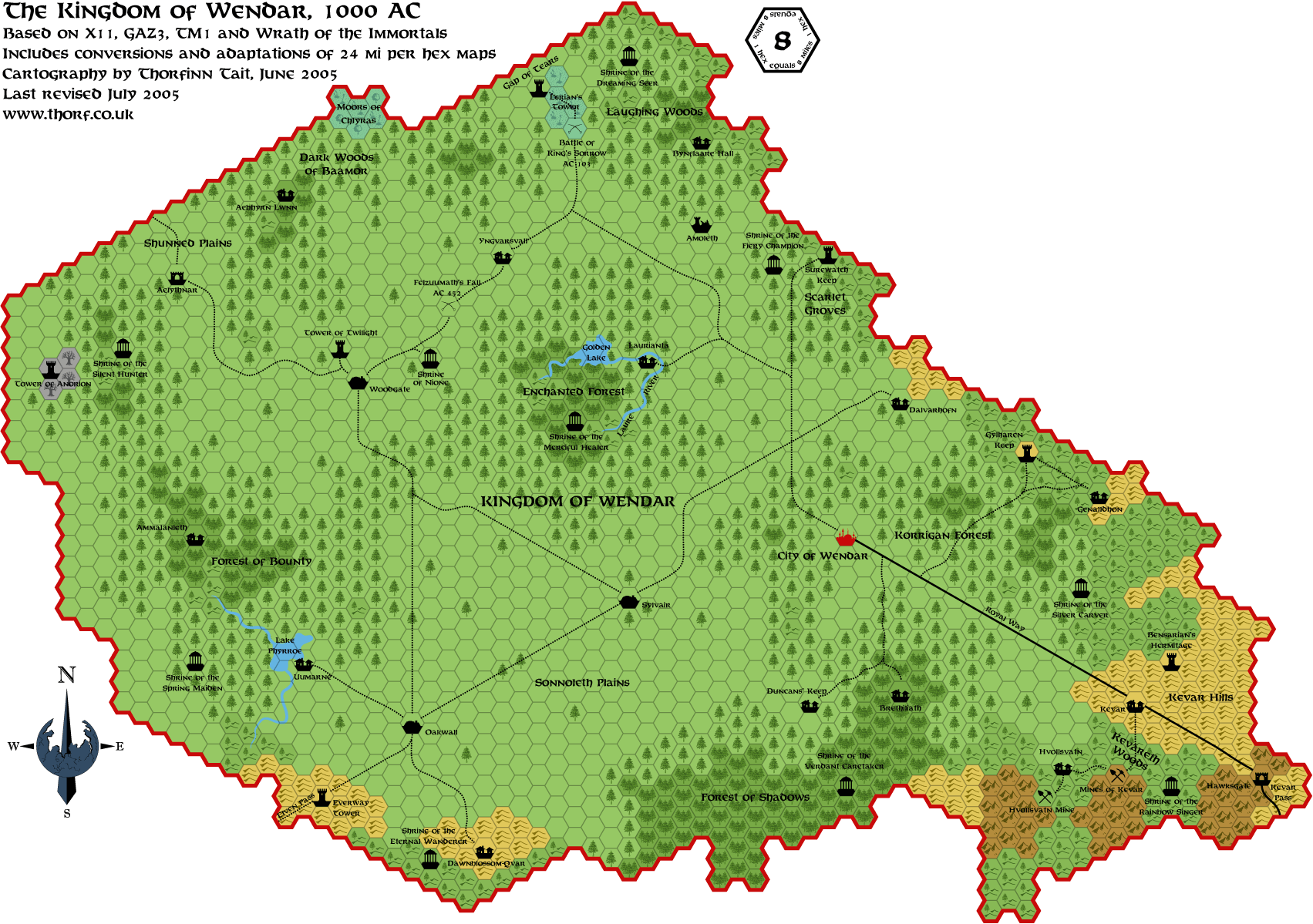 Note: The original June 2005 map has been lost. This is the first version available, but it dates from three weeks later. —Thorf, Dec 2020
Basically, the map is just a conversion of the 24 mi per hex maps provided in X11 and Wrath of the Immortals.
Where those maps disagree with each other, I made a judgement call. Also, I have placed the western border
at the bottom of the Adri Varma Plateau. Otherwise, it is pretty faithful to the smaller scale maps. |
29 June 2005, 4:37:37
|
 |
Member |
|
|
|
maybe you should leave the map empty, and every DM can add his own places...
oh, and...
Your maps are amazing.  |
29 June 2005, 4:54:24
|
|
Member |
|
Join Date: Apr 2004
Location: Denmark
|
|
Wow! That really is quite empty! 
It's beautiful, though. Can't wait to see it populated by settlements.
BTW, why is there both a trail and a road next to each other in the SE corner of the map?
:-) Jesper |
29 June 2005, 5:38:47
|
|
|
|
Join Date: Jan 2004
Location: Italy
|
|
In order to spare you painless hours of reading I am cut&pasting here the paragraph I wrote about Wendar's geography in the MA.
See if it can be of some inspiration to your mapmaking, Thorf.
Nestled among two plateaux and two mountain ranges, Wendar (or Genalleth, as the elven race calls it) is a secluded and ancient land that still holds many secrets and marvels even to its inhabitants. Thick evergreen forests blanket more than a half of this region, their beauty and stateliness mirroring the Canolbarth Forest in its glory days. There are four major "reserves" (this is the best translation of the way the elves call them) in Wendar, all closely guarded and tended by Genalleth elves.
The first and most important one, Korrigan Forest, lies in the western part of the nation, touching Wendar City and Sylvair, the two most thriving Wendarian cities. It is renowned for the beauty of its sequoias and for the many shrines sacred to the Korrigans, the Nine Elven Protectors that watch upon Genalleth. The legend says that they drew their name from the mythical (and believed extinct) korrigan, a woodland animal that once lived here.
The Forest of Bounty (now renamed Forest of the Curse after the events of AC 1013 and 1014) lies in the southwestern corner of the nation and is currently inhabited by the Alfheim refugees. Mighty and sturdy oaks grow here, protected by a small group of treants that the elves call "The Elders." Woodgate and Oakwall, two other towns, lie at the easternmost border of this forest, and use its wood to boast their logging industry.
Right at the centre of the Genalleth Valley we find the Enchanted Forest, a mysterious patch of trees that the elves hold as sacred. According to the legends, here live the fairies with their sylvan friends, the centaurs and actaeons, and those who dare trespass against Nature in this place are bound to be abducted by actaeons and to serve the fairies for the rest of their life. Tales of missing wanderers abound in this region.
The last important reserve lies at the northwestern border and is referred to as the Dark Woods of Baamor. The Wendarians tell frightening tales about this area, whose trees are strangely darker and more twisted than the common trees of the region, and whose fauna is made up of deformed and evil parodies of the common woodland animals. Elven sages blame this to a mysterious being (or race, this is not clearly defined) called Baamor, who tried to poison the entire continent in the ancient days to appease the Dark Immortals. However, the Korrigans rebelled against Baamor and ultimately defeated him, imprisoning the evil Baamor inside one of the blight trees of this forest. Therefore, in order to avoid freeing him, it is strictly prohibited to cut down any tree in this region. In fact, few people venture there, for it is said that Baamor tries to possess anyone who walks into his forest and use him to achieve freedom.
The rest of the region consists of rocky hills to the east and to the south, where the few herders raise their cattle (horses and sheep mostly). In the central plains and moors the humans raise their crops. The valleys and plains are usually safe and free of monsters, but the more one gets to the mountain ranges, the more the trip becomes dangerous.
The Wendarian Range to the south and the Mengul Mountains to the north are renowned for their snow-capped peaks and for the fierceness of their inhabitants. The Wendarian Range, whose peaks average 11,000 feet in height, is home to many tribes of yeti, sasquatches and even a few white dragons.
The only two southern passes maintained and guarded actively by the Wendarians are the Elven Pass to the southeast, which leads directly to Oakwall, and the Kevar Pass to the southwest, from which the Royal Way leads to the capital winding through the Korrigan Forest. There is a third pass leading northwards through the Mengul Mountains and up to Denagoth, but it has not been used since the last war with Essuria, about 80 years ago. Gylharen Keep has been built near the border with Denagoth under the supervision of King Gylharen, and the standing garrison has the sole purpose of stopping (or slowing) any possible invasion attempt from that land. However, since Denagoth has not given any significant trouble in the last decades, the soldiers stationed here have taken on the duty to harass and annihilate any humanoid band trying to cross the border and cause mayhem in Wendar; so far, they've been successful. |
29 June 2005, 5:43:43
|
|
Community Assistant |
|
Join Date: Mar 2001
Location: new york
|
|
oops Harri I forgot about that, is that you meant Geoff? |
29 June 2005, 6:02:55
|
|
|
Did I wrote Greg, of course I ment Geoff. Not the first time I'm using wrong names lately...  |
29 June 2005, 8:03:30
|
|
|
|
Join Date: Feb 2005
Location: Ontario, Canada
|
|
More places
Here are some more places you might wish to add to the map...
Lerian's Tower (located in the clear gap near the word "maps"): This tower was built by a distant cousin of one of the first kings of Wendar to secure the northern marches. Much beloved by the king, the cousin was granted a great deal of autonomy, and ruled the northern frontier as his own domain. The details of his treachery are now lost (likely destroyed), but the cousin turned against the king, and a great civil war ensued, spilling much blood in the lands surrounding the tower (which was thereafter named the Gap of Tears). The king prevailed, and the cousin's name was struck from all the records. He would have demolished the tower, too, but for its strategic importance. The king's son, Lerian, offered to give up the crown and guard the northern border - a duty he upheld until his death 330 years later. Thereafter, the tower was named after Lerian in his honour. Today, it is well garrisoned, with a scattering of human farms surrounding it.
Shrine of Nione (located NNW of Woodgate): Nione was an elven heroine of great renown centuries ago, whose deeds are still sung. During a great battle against a Denagothian horde, she slew Felzuumath, a fearsome mountain giant who commanded the evil army (which broke up soon afterwards in disarray), but died of her injuries soon afterwards. Her heroism allowed the crown prince, who was commanding the Wendarian armies, to escape to safety. Out of gratitude, the crown price built a beautiful shrine to honour the hero. Today, many Wendarians who dream of becoming heroes make a pilgrimage to the shrine to seek Nione's guidance, and to pay homage. Some even claim to have received visions while visiting.
Yngvarsvall (located in the clear land between Woodgate and Lerian's Tower): Another village populated primarily by people of Heldanner stock. Military wagons going between the town and the tower often use the village as a rest stop. As a result, a small, but moderately prosperous, group of craftsmen and burghers grew up here, trading their services for the soldiers' coin.
..maybe add a mine or two in the south, where the mountainous bits are...
Geoff
|
29 June 2005, 8:44:00
|
|
Member |
|
Join Date: Jan 2005
Location: Akita, Japan
|
|
Duncan's Keep?
Quote:
If the settlement makes it onto your map I will have to flesh it out some more of course! |
Duncan's Keep... it sounds like a tower, similar to Grunturm in Heldann, right? Care to write a capsule description? Also, where would you like it placed? |
29 June 2005, 8:47:58
|
|
Member |
|
Join Date: Jan 2005
Location: Akita, Japan
|
|
Quote:
From X11 (map VI):
- the scorched battlefield (encounter #2, p.5)
- the Castle/Tower of the Cloud Giant (encounter #6, p.6-9)
From X11 (map VII):
- the Bengarian Hermitage
Not much beyond that, I am afraid |
I don't think the scorched battlefield is really a major enough battle to require a battlefield symbol, is it?
And the Castle of the Cloud Giant is across the border, in the much more well detailed country of Denagoth. I'll be doing that too, eventually! |
29 June 2005, 8:50:00
|
|
Member |
|
Join Date: Jan 2005
Location: Akita, Japan
|
|
More replies
Quote:
Wow! That really is quite empty! |
You can see why I thought it didn't look right, can't you? (Note: I will be updating the map as we go, so if you're reading this later you probably can't see how empty it originally was! )
Quote:
|
BTW, why is there both a trail and a road next to each other in the SE corner of the map? |
Because I haven't worked out which is the correct spot to connect to the trail/road into the Heldannic Territories yet. |
29 June 2005, 9:53:39
|
|
Member |
|
Join Date: Jan 2005
Location: Akita, Japan
|
|
I updated the map. Scroll up to see it!
I decided to put Gylharen Keep on the Heldann border, at Kevar Pass, because Surewatch Keep seems like a good name for the Denagoth garrison. And I placed a mine in the mountains near the village of Kevar.
I also noticed that there is not really any suitable symbol for shrines. So for now I have improvised with a tower symbol. There is a shrine symbol in HWR3, I think, or perhaps I could design a new one, if necessary.
Marco, I'm a little confused about the forests, because it seems to me that there are actually more than four. I marked them according to your description, although I notice that Thibault's map has the forests quite different from mine, and also the labels are in different places. He also has the northern border placed much higher than X11 and Wrath of the Immortals have it.
Talking of borders, does anyone have any issues with my current border? It can easily be adjusted one hex in or out at most locations, and still be roughly in line with the 24 mi per hex border. I've been thinking of adding some "bumps" along the Denagoth border, to break up the current straight line of mountains there a bit.
|
29 June 2005, 10:34:14
|
|
|
|
Join Date: Feb 2005
Location: Ontario, Canada
|
|
Quote:
|
I updated the map. Scroll up to see it! |
Lovely!
Quote:
|
Talking of borders, does anyone have any issues with my current border? It can easily be adjusted one hex in or out at most locations, and still be roughly in line with the 24 mi per hex border. I've been thinking of adding some "bumps" along the Denagoth border, to break up the current straight line of mountains there a bit. |
That sounds good to me. Let me know if you want more villages or points of interest.
Geoff |
29 June 2005, 10:49:22
|
|
Member |
|
Join Date: Apr 2004
Location: Denmark
|
|
Quote:
|
Duncan's Keep... it sounds like a tower, similar to Grunturm in Heldann, right? Care to write a capsule description? Also, where would you like it placed? |
I'll write a small capsule description a.s.a.p.
In the meantime, I think Wendar should have some manner of water; either rivers or lakes. It looks a bit funny to be the only map without water at all
:-) Jesper |
29 June 2005, 11:06:36
|
|
Member |
|
Join Date: Jan 2005
Location: Akita, Japan
|
|
Quote:
|
That sounds good to me. Let me know if you want more villages or points of interest. |
The more the merrier, really. Possible additions include villages, towers, ruins, battle sites, mines and of course small areas of other terrain types, most likely moor or small stands of trees.
Regarding water, I think the main problem is that there isn't really a good place for water to go, because the country is surrounded by high mountains and a plateau, with only the northern border clear. So there's no obvious runoff for a major river.
On the other hand, you can be sure that there will be lots of minor streams and burns, even if they aren't marked on the map. (As is always the case.) As to where these all go... |
29 June 2005, 11:20:59
|
|
Member |
|
Join Date: Apr 2004
Location: Denmark
|
|
water
Quote:
Regarding water, I think the main problem is that there isn't really a good place for water to go, because the country is surrounded by high mountains and a plateau, with only the northern border clear. So there's no obvious runoff for a major river.
On the other hand, you can be sure that there will be lots of minor streams and burns, even if they aren't marked on the map. (As is always the case.) As to where these all go... |
Well, it's been a long time since I opened a book about geography and rainfalls and such, but wouldn't the water simply spread out across the lowlands and seep into the ground?
Or it might run NE into the Northern Wildlands on the map from X11?
Or it might run into a lake and from there down into Shadowdeep, forming some of the underground lakes and river where the shadowelves live?
:-) Jesper |
29 June 2005, 12:02:19
|
 |
Member |
|
|
|
Water
Generally speaking, water flows to and collects in the lowest points of any given area. Where a lot of water is involved, the watertable will rise considerably and this will form lakes, ponds, and small streams in the lower areas that are not suited for large rivers.
Conceivably, Wendar could have numerous small lakes, ponds, bogs and marshes amid the forests and settelments- Think Lower Germany, earlier first century AD, when the Battle of Teutenberg Wald took place.
|
29 June 2005, 12:46:27
|
|
Member |
|
Join Date: Apr 2004
Location: Denmark
|
|
Quote:
|
Generally speaking, water flows to and collects in the lowest points of any given area. Where a lot of water is involved, the watertable will rise considerably and this will form lakes, ponds, and small streams in the lower areas that are not suited for large rivers.
Conceivably, Wendar could have numerous small lakes, ponds, bogs and marshes amid the forests and settelments- Think Lower Germany, earlier first century AD, when the Battle of Teutenberg Wald took place. |
I like the idea of more bogs and marshes on the map. It would certainly create some interesting places for more dangerous wildlife and monsters... 
:-) Jesper |
29 June 2005, 12:53:12
|
|
Member |
|
Join Date: Jan 2005
Location: Akita, Japan
|
|
Quote:
I like the idea of more bogs and marshes on the map. It would certainly create some interesting places for more dangerous wildlife and monsters... |
I agree. I'd like to place some moors somewhere in Wendar, as I noted above somewhere. There is somewhat of a shortage of moors in the Known World.
I'm still a little reluctant to add major water features, but I might be persuaded to add some minor streams and pools, I suppose... But I think it's probably best to have them in the geographical description rather than actually on the map. |
29 June 2005, 13:14:33
|
|
|
|
Join Date: Feb 2005
Location: Ontario, Canada
|
|
Quote:
|
The more the merrier, really. Possible additions include villages, towers, ruins, battle sites, mines and of course small areas of other terrain types, most likely moor or small stands of trees. |
OK.....looking at Shawn's and Marco's timeline, Wendar rose as a modern kingdom in AC 910 under Gylharen. However, the towns and villages have been members of defensive leagues in the past, so there could possibly have been many elvish (and maybe a few human) nobles or self-styled kings, each ruling a petty dominion. All this to say that there could very well have been many battles between the towns and various factions - just a note.
Battle sites:
Felzuumath's Fall (AC 452) : Located 5-6 hexes NE of Woodgate, this is where Nione fought and killed Felzuumath, who had terrorised the towns of western Wendar for many years. The victorious elves of Woodgate piled their enemies into a mound and burned them. Since that time, grass has grown over the remains, and now a fair-sized grassy hill stands alone.
King's Sorrow (AC 103): Located one hex south of the word "tower" in Lerian's Tower, this is where the elf king of Amoleth fought, and killed, his beloved cousin. Surviving accounts of the battle say that so much blood was spilled that day, that the plains had become a reddish swamp.
Ruins:
Amoleth: The ruins of Amoleth lie along the southern fringes of the forest to the east of Lerian's Tower. It its heyday, it was the capital of the kingdom of Amoleth, an elvish realm that stretched across what is now northwestern Wendar. A strong ally of the other elvish realms, its soldiers fought numerous Denagothian hordes. The Battle of King's Sorrow broke the king's spirit, and the realm began to decline thereafter. During the chaotic period surrounding the bloody campaigs of Felzuumath, the giant's armies laid the town to siege. Unable to secure aid from its neighbours, and with the garrison of Lerian's Tower unable to reach the town in time, Amoleth fell in AC 433. Most of the population was slaughtered, but a handful managed to escape and bring word to other towns and villages. Elvish fury over the loss of Amoleth united them long enough to wage a successful campaign against their enemies, ultimately leading to the Battle of Felzuumath's Fall.
Geoff |
29 June 2005, 13:31:37
|
|
Member |
|
Join Date: Apr 2004
Location: Denmark
|
|
Duncan's Keep
Duncan's Keep is a tiny settlement on the edge of the deep forests south of Wendar City and southeast of Sylvair. It is named after the founder, who many years ago was given a fief and instructed to build a small fortified tower to keep the area safe.
Today, Duncan's Keep is home to some 70 families, a mix of humans and elves. Their primary source of income is from woodcutting, timber export and manufacturing goods out of wood.
The local mayor is a human woman named Agnes Stellasdottir of Heldann descent. For a brief periode a few years ago, she was the lover of the proud Soderfjord warrior Emrode, when he and his companions were in town after slaying a nearby green dragon that was threatening the community.
From that relationship Agnes bore a son, who is now a little over a year old, named Axel Emrodeson. Agnes does not know where Emrode is today but hopes that he will return to Duncan's Keep one day.
Other notables in the tiny hamlet includes Baron Duncan III, grandson of the founder, whose wife died of sickness years ago before bearing him any children. The people of Duncan's Keep are loyal to their baron but realise that he is now too old to marry again and most people expect that either will the King bestow the barony upon another line or ask Baron Duncan to name one of the villagers his heir.
Most of the villagers hope that would be Agnes, but a few ambitious others are secretly working to improve their own standing with the baron. One of them is the gnome merchant Theodor Thunderburp who has made a small fortune exporting quality wooden goods to Glantri and the Heldann Freeholds. He is quite a comical figure, always making speeches at the tavern or on the village square about how "a person who has had success financially would be the best choice to secure prosperity to the entire village" and such slogans. Theodor has the odds against him, however, because for all his wealth most villagers still consider him a good-hearted clown.
The second contender is a daydreaming bard named Jonaleth Silverbrim from Darokin. He came to Duncan's Keep broke and soon learned about the local political situation. He hopes to become the next baron by woeing Agnes and marrying her, so that when she enherits the barony, he will become baron. Jonaleth is as much an amateur as Theodor but much more scheeming. He is not above sabotaging Theodor's speeches, adding to the poor gnome's ridiculous reputation.
The real threat to Duncan's Keep is from the third contender for the throne, a local elven priest of the Korrigan named Meetholan. He is the head of the local chuch and much more strict (LN) than most elves. He feels that the humans are violating nature around Duncan's Keep and because of their short lifespans and lack of inherent magic abilities inferior to elves. In short, he is a racist. If he inherits the barony, it will turn into a hagiarchy, an area ruled by holy men. And that is sure to put an end to the current prosperity and lessen the lives of humans to those of serfs.
Whatever will become of Duncan's Keep in the near future is up to the DM. Perhaps Emrode and his group will return. Perhaps another party of adventurers will come by and resolve the situation. If not, one of the three contenders will probably get the throne, and the changes will probably send ripples through Wendarian nobility all over the country,
:-) Jesper
|
29 June 2005, 13:50:46
|
|
|
Join Date: Feb 2005
Location: Ontario, Canada
|
|
Still more
Hvollsvatn (located SW of Kevar, not too far from the mines): Hvollsvatn was founded in AC 960 by refugees from the Heldanner town of Skolgrim (now Grauenberg). Although they initially settled in Kevar, frictions with the local humans forced them to petition King Gylharen for permission to settle elsewhere. The king granted them land near the forested hills south of the Royal Way, and gave them mining and limited forestry rights. The region was sparsely inhabited beforehand, and would, he reasoned, provide a stable population base to make the land productive, and from which armies could be raised should tensions with Heldann or Denagoth ever boil over. Today, many people in Hvollsvatn are miners and smelters, selling the iron ingots to merchants who will then transport them to Kevar, Wendar City, and occasionally Sylvair. Hvollsvatn is also known for its competent smiths.
Geoff
|
|
|