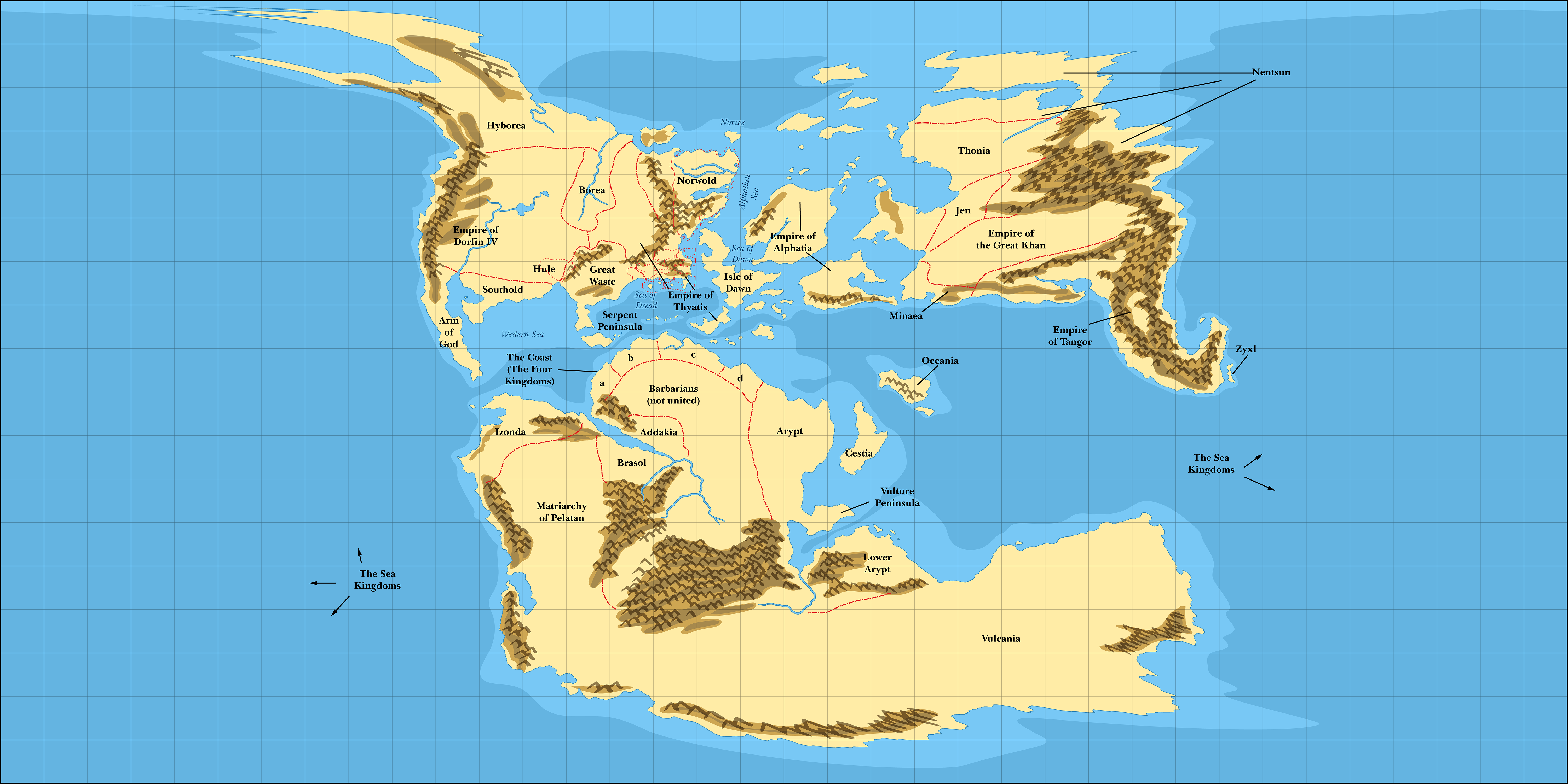
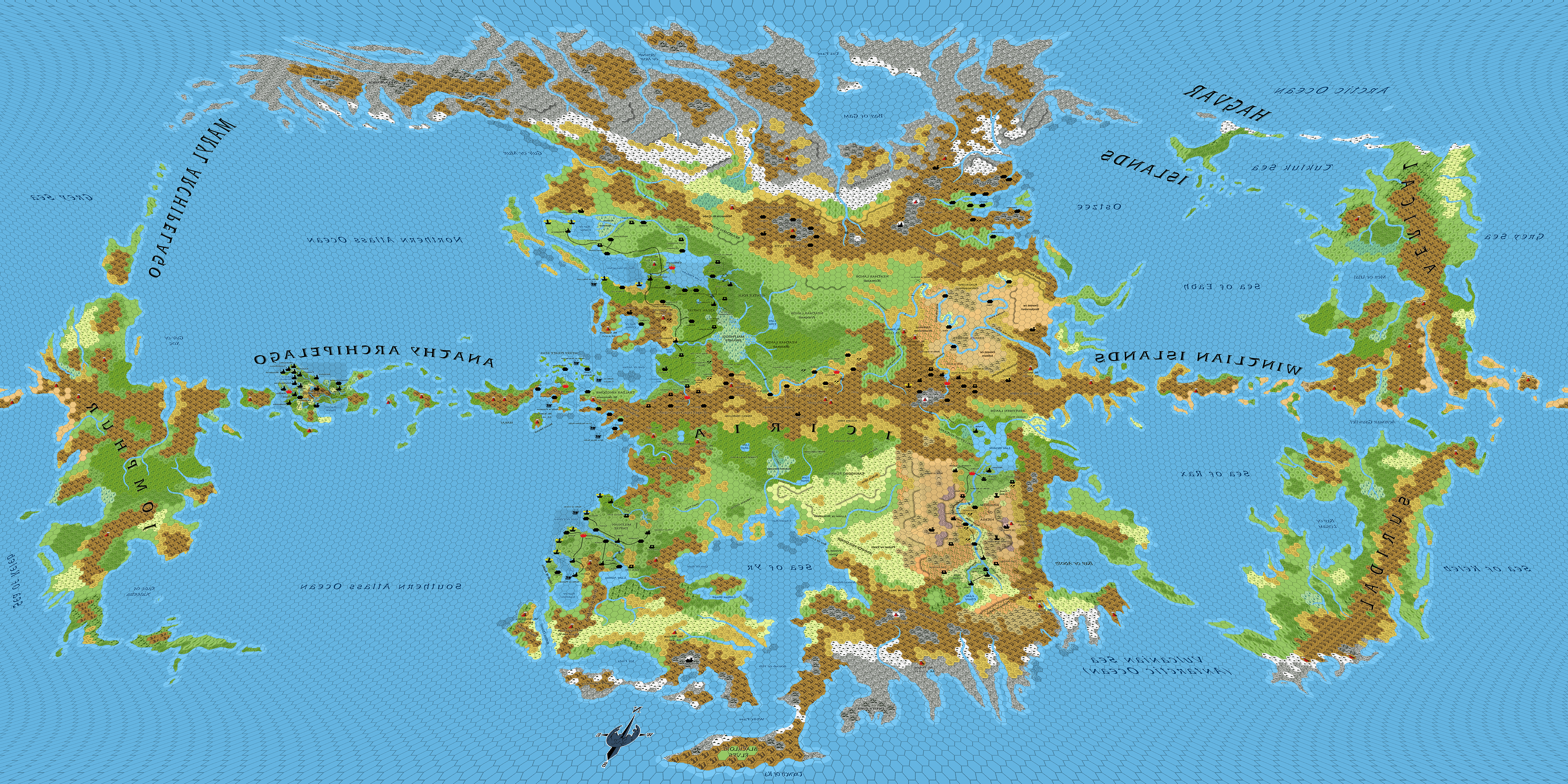
This is a test page, showing the correlation between Mystara’s inner and outer worlds. For now, it uses an Equirectangular projection of Let’s Map Mystara 1985’s world map, overlaid on an Equirectangular projection of the Atlas of Mystara’s 40 mile per hex Hollow World map.
The Hollow World map has been reversed, so that all of the text is mirrored. In the final version of this page, this will be fixed, but since it’s not an easy fix I have left it as is for now.


Let’s check the official correlations — the Palace of Atruaghin and Quauhnahuac; Aegos and Alphatian Neatharum (at the source of the Nograi River).
Alphatian Neatharum seems to line up roughly okay; it’s not a direct match, but close enough.
Quauhnahuac, unfortunately, lines up with Borea, hundreds or possibly even thousands of miles away from the Palace of Atruaghin. This one is more problematic. On the other hand, Quauhnahuac’s location is derived from a textual addition in HWR1. The simplest solution would be to simply adjust its location so that it lines up better with the Palace. In this case, it looks like it should be moved to somewhere north of Colima.
This doesn’t seem too bad an alignment — it could have been much worse. Please feel free to share your thoughts below.

18 August 2020 @ 12:51 am
You already know I’m a huge fan! I was thinking it might be useful to have a tool where I can see the two maps side by side, select a location on one map, and have it flag that location on the other map. The current tool is super useful for a quick look at general locations, but it could be useful to be able to be more specific with locations.
18 August 2020 @ 8:33 am
Having both maps side by side, or more likely above and below, is no problem. But unfortunately I haven’t yet found a way to do what you describe.
One thing I could do is a simple two-layer web map, allowing you to turn the top layer on and off, but that amounts to the same as the system above, doesn’t it?
If anyone with more web expertise than me has any ideas, I’d love to hear them.
18 August 2020 @ 1:01 am
I’m also curious; is there really so much empty ocean between western Brun and eastern Skothar? It looks as wide as all the continents together, and while that would certainly explain a lack of trade between those locations, it doesn’t look nearly that large on the other world maps.
18 August 2020 @ 8:44 am
This is a question that comes up repeatedly. The short answer is yes.
As to why, the answer lies in the Jurassic Earth map that Mystara is based on. 150 million years ago, when the continents were roughly as they appear in Mystara’s maps, the Pacific Ocean was far larger, and it was known as the Panthalassic Ocean. When the continents were all merged into Pangaea, it was larger still, but by this stage it had already begun to shrink as the continents moved apart once again. (The Pacific Ocean is a different ocean in the sense that the sea floor of the Pacific is almost entirely new, having been subsumed back into the crust and replaced by new ocean floor. Hence the different name.)
Since Mystara is based on Jurassic Earth, and as I found in my examinations back in 2018 the map is inherently tied to the Mollweide projection used on those maps, the massive Far End Ocean is inevitable.
By the way, the Master Set world map avoided this by simply cropping out the empty oceans, and not showing the edge of the oval-shaped world map at all, leaving readers to assume the rectangular border was the map edge. (It wasn’t.) The Hollow World Set world map took that idea and ran with it, creating a world map with the land stretching from far west to far east, but in doing so it actually stretched the land completely out of proportion.
4 March 2021 @ 1:03 am
Hi Thorf. I see this was posted 8 months ago but I’ve only just found it. Clearly I’m not paying attention. I’m interested in the lack of join up between the known link points (Aegos and Atruaghin) and their Hollow world counterparts. Given the odd Hex size (40) for the HW map, I wondered if it was intended to generate a 1:1 hex ratio with some scale of the surface. A bit of experimentation shows that, using a surface map at 72 miles per hex, you can count hexes from Aegos to southern Atruaghin and the same number of hexes in the HW gets you from Quauhnahuac to the location of Haldemar in Neatharum pretty much exactly. This ratio also lines up very closely with the sizes for Mystara and the HW that Ann Dupuis put on the message board years ago. I suspect therefore that the intention was for hex-to-hex alignment rather than long/lat as the HW book implies.
Given everything you’ve built and your expertise, I also suspect that there’s a massive flaw in this logic, but I’m interested to know what it is. Is it the size of the back ocean throwing everything off? Did they make it align between Azca and the Known World but then muck up everything else? I wondered if it was caused by them treating the Mollweide projection as equirectangular and assuming it would all work. Any thoughts? Thanks.
10 March 2021 @ 7:48 pm
Since it’s just a test still, I haven’t made much effort to spread word about this page. I’m actually not quite ready to make the proper page yet, for various reasons.
The link up you describe probably works fine with the hex maps, as that is where the original designers calculated it, I am sure. However, there are numerous other problems that mean a direct link up like that is highly unlikely to work out. The most significant of these is the fact that the world is far bigger than the official books say, if you calculate its size based on the dimensions of the hex maps. This specifically affects the Outer World; the Hollow World didn’t seem to suffer from this sort of miscalculation nearly so much.
Theoretically, the two worlds could be aligned based on the known points that are supposed to line up. Which is to say, we could just make Atruaghin and Quauhnahuac line up, or Aegos and Alphatian Neatharum — but probably not both. The other source for alignment of inner world to outer is the Princess Ark episode where they move from southern Davania to the south of the Hollow World, but they actually end up in Oostdok. And of course the maps of the polar openings.
But the biggest problem is that the Hollow World set Outer World map is completely wrong, so the polar opening maps are also basically rubbish.
Yep, it’s all a bit of a mess. Luckily, these elements lining up is not nearly as much of a problem as you might think. Sure, it would be nice if they did, but bearing in mind the thousands of miles of crust between them, in fact it’s pretty irrelevant — as long as they are reasonably close, it should be fine. Links going through the earth don’t have to be vertical shafts, after all.
18 November 2023 @ 12:46 am
Been referencing your site for a few years now. I tend to use the Savage worlds Rule System, but I’ve always loved the Mystara setting.
Thank you so much for all your hard work over the years to bring us such well done maps!!
19 November 2023 @ 9:53 pm
You’re most welcome! Hopefully the best is still to come, but wow there’s so much left to do.