
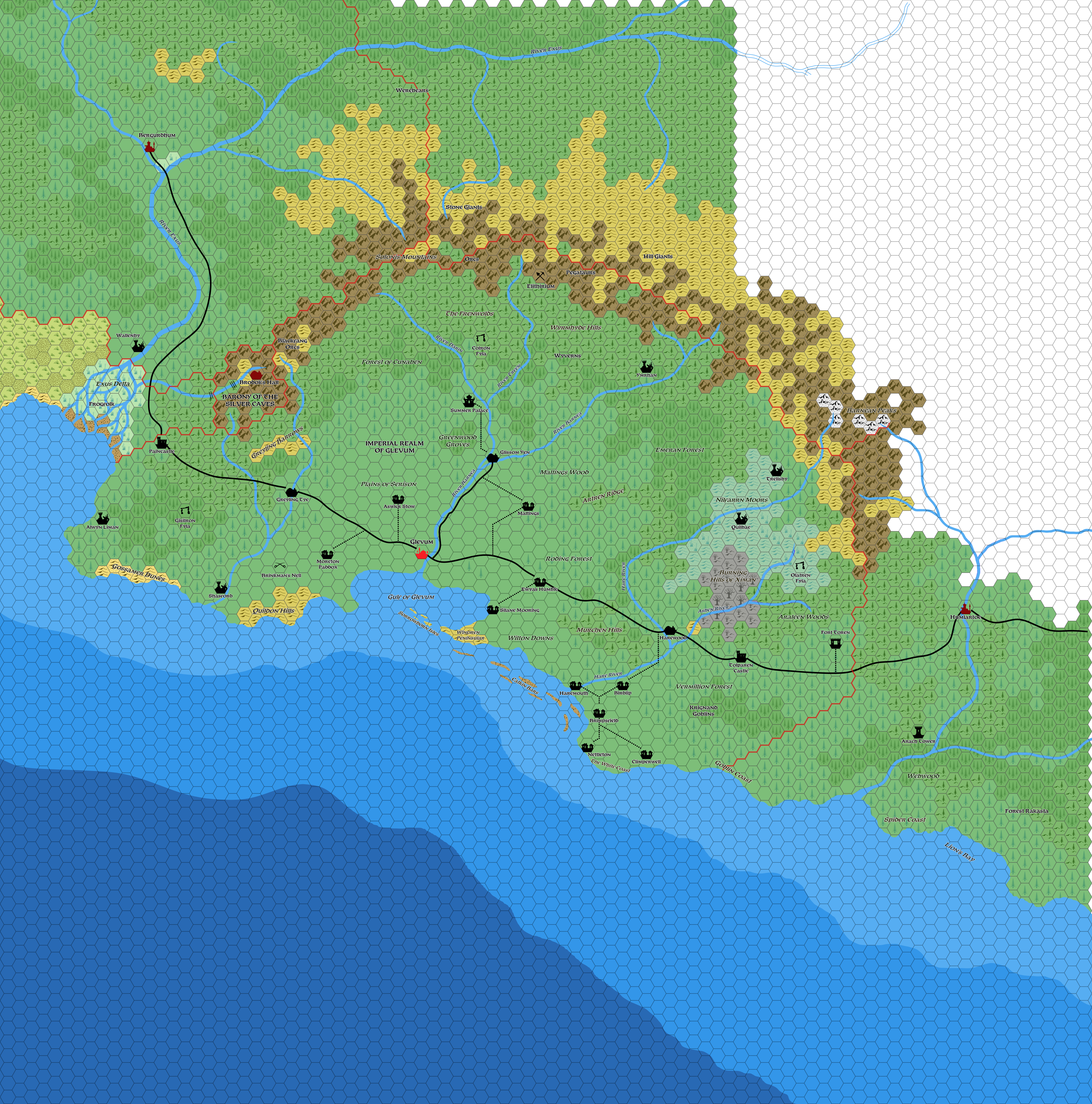
Mark’s Glevum, 8 miles per hex v1
After posting his regional map of Thonia in northwestern Skothar in May 2021, Mark shared his first draft of an 8 mile per hex map of a Thonian nation a few months later. Although it was still a work-in-progress, the main part, the Imperial Realm of Glevum, was complete. In his blog post, Mark described it as follows:
The Imperial Realm of Glevum is the personal fief of the Emperor of Thonia. Although not the largest by area, it is the most populous and the safest area in the Empire. Most visitors to the Empire never leave this land.
Even here though, much of the land has been reclaimed by the forests, humanoids, undead and the Irith, leaving ruined settlements and hidden secrets in their midst.
He went on to describe most of the named locations on the map.
This detailing of Thonia is great to see, and I’m sure Mark will provide us with more details — and more maps — in due course.
Fan-made Map by Mark Howard (August 2021)
This is an original map created by one of Mystara’s excellent fan cartographers. For more information on the cartographer, including a gallery of all their maps, see also Appendix M: Mappers of Mystara.
Work in progress map: This map is incomplete. It appears here in the most recent state available, but it may be missing certain elements.
Sources
- Master Rules Set (1985) (PDF at DriveThruRPG)
- Dawn of the Emperors (1989) (PDF at DriveThruRPG)
Fan Sources
- Mark’s Empire of Thonia, 24 miles per hex (May 2021)
- The Imperial Realm of Glevum at Mark’s web site (August 2021)
References
- All of Mark’s maps at the Atlas of Mystara
- Mark’s entry in Appendix M: Mappers of Mystara (upcoming)
- Mark’s author page at the Vaults of Pandius
Chronological Analysis
This is a fan-made map. It was published in August 2021. The updated Atlas version of this map is not yet available. See also Appendix C for annual chronological snapshots of the area. For the full context of this map in Mystara’s publication history, see the upcoming Let’s Map Mystara 2021.
The following lists are from the Let’s Map Mystara project. Additions are new features, introduced in this map. Revisions are changes to previously-introduced features. Hex Art & Fonts track design elements. Finally, Textual Additions are potential features found in the related text. In most cases, the Atlas adopts these textual additions into updated and chronological maps.
Under Construction! Please check back again soon for updates.
")
")
")