Pioneering creator of beautiful digital maps
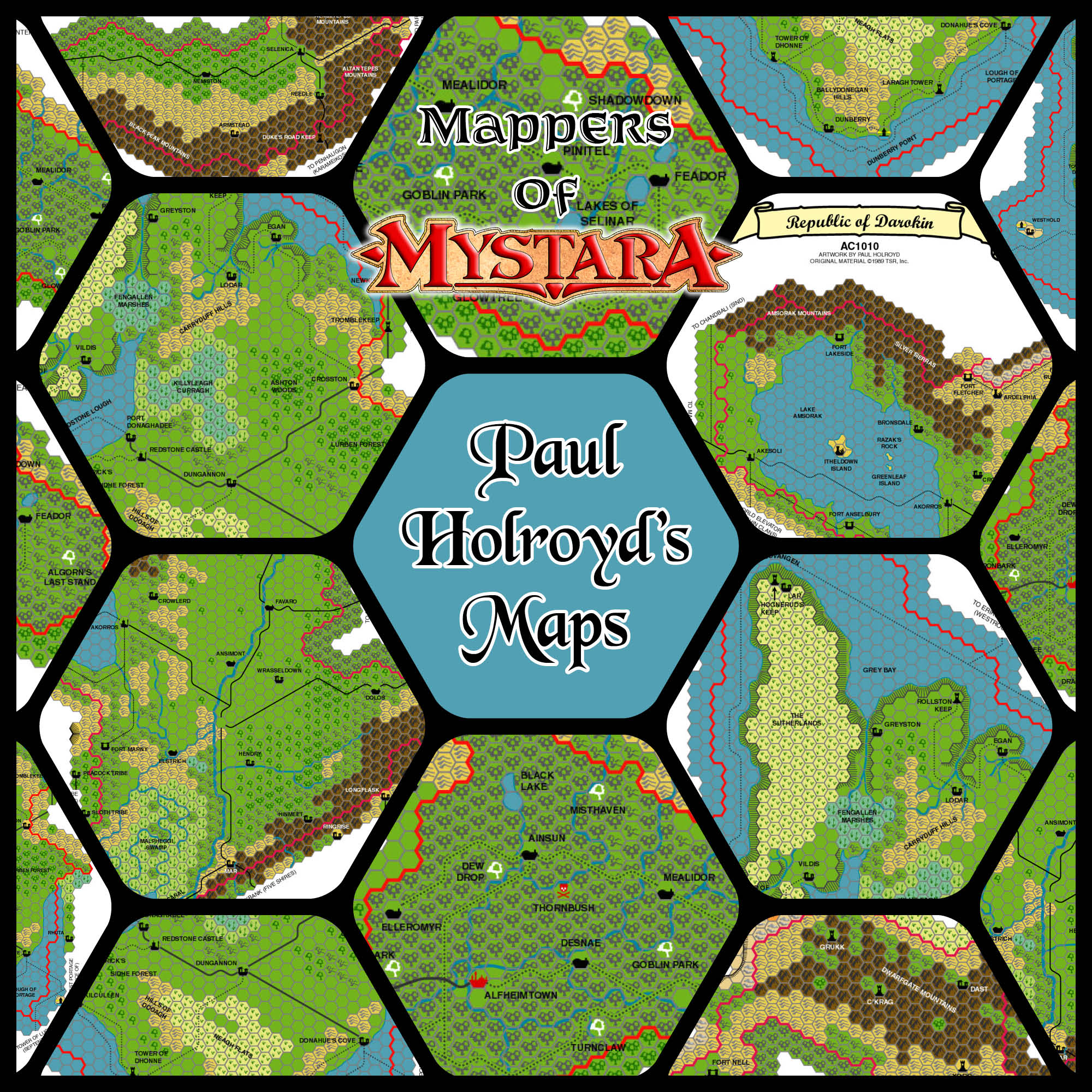
At a time when everyone else was working with raster software, Paul did his mapping with vectors in Adobe Illustrator. Although he only created a small number of maps, they have since been used and reused by the community repeatedly, and remain popular to this day.
Profile
- Nickname: Hoddie (Vaults author page)
- Location: England, UK
- Maps Posted: 1999
- Areas of Interest: Known World, Isle of Dawn
- Scales: 8 miles per hex
- First Posted Map: Republic of Darokin, 8 miles per hex (August 1999)
- Software: Adobe Illustrator
- Mapping Style: Detailed hex art with a subdued, professional-looking palette
- Fonts: Monotype Script (titling), Black Chancery (titling), American Uncial (titling), Helvetica (labels)
Overview
I thought that WotI was the best thing to happen to D&D (or Mystara) — it made it feel like a ‘real’ world with real problems. I don’t think everything is moving too fast — everything that has happened in the PWAs (official or not), seems plausible within the context of Mystara’s history.
“Just Say No to WotI”, 1st September 1999, MML
Paul joined the Mystara Mailing List (MML) in February 1999, expressing his love for D&D and Mystara, and his desire to get back into it. He had strong opinions about what had happened with the demise of old D&D, the subsequent botched transfer of Mystara to AD&D, and the eventual dropping of the “Advanced” monicker.
He also had an interesting view of Wrath of the Immortals, leading to a love of the Poor Wizard’s Almanac series, as well as the fan-made Mystaran Almanac series that followed.
It was becoming boring following the B and then the X series through. That’s why I was so excited when WotI came out. When I first bought it I only thought it was to replace the Immortal rules of old (which I never managed to purchase), but since I started reading I have never looked back. I was pretty annoyed when they moved the PWA to AD&D but I thought what the hell? As long as they continue. I was quite upset when they even stopped that, but I found saviour on the net in the form of AC1014 and AC1015 — which in many respects are even better than the published ones.
“Just Say No to WotI”, 1st September 1999, MML
Maps
Paul’s major contribution to the Mystara community came in August 1999, when he started talking about the maps he was working on.
Anyone interested in a jpg file of a map of pre-WotI Darokin?
“Maps”, 28th August 1999, MML
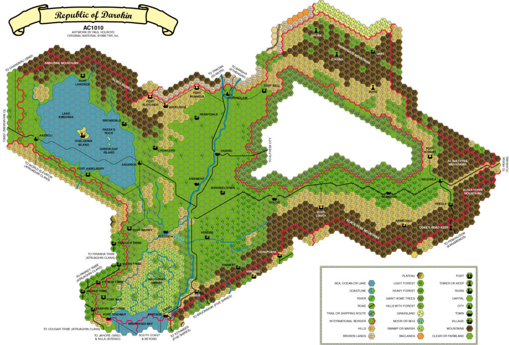
A few days later, he posted a link to his excellent Darokin map. Although the map was labelled “AC 1010”, in fact it was designed for 1000 AC.
Er, the date was a mistake – it should read AC1000. Besides, I’m fairly unsure as to where the crater should be, as the map available on the ‘net doesn’t affect Darokin at all, but from what I remember from the PWA (which I don’t have any more), some of Lake Amsorak was lost (along with Fort Lakeside). I may be wrong, but that is why I made a pre-wotl one.
“Maps—Darokin”, 1st September 1999, MML
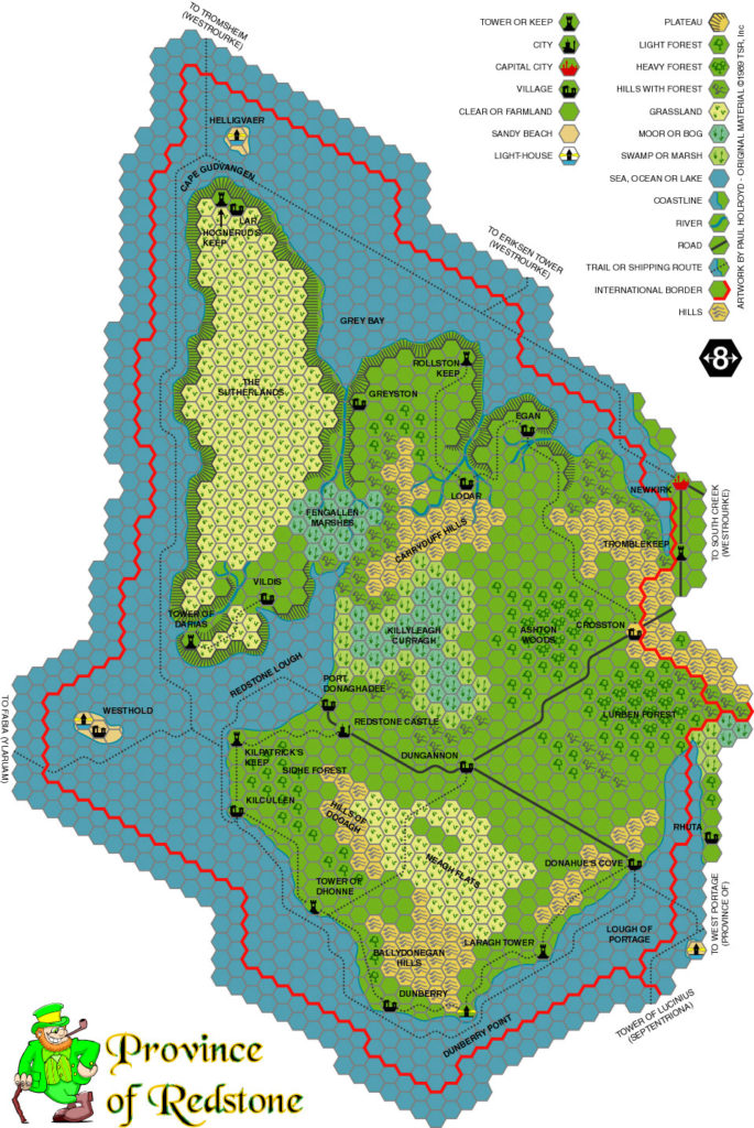
Just a few days later he posted a second map, the Province of Redstone on the Isle of Dawn, followed just one day later by his Kingdom of Alfheim map.
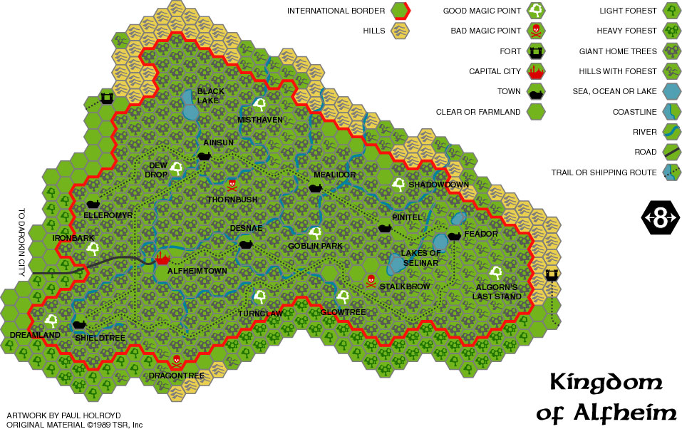
Paul’s maps were exceptional for their quality. He custom-designed his own set of hexes in Adobe Illustrator, and the results were top class for the time; only Christian Constantin’s maps came close in terms of aesthetics.
The best thing I’ve used is Adobe Illustrator but it’s hardly cheap. It does do great rivers though and you can turn layers on and off as you need them. For example, you could ‘hide’ the hexes while working in detail and then turn them back on before saving.
BTW – Glantri is a toughie as it is all bloody river!! 😉
“Maps in the works”, 30th August 1999, MML
He talked of a wish to map out other areas, including other Known World nations and Alphatia, but it wasn’t to be, and he drifted away from the project.
Paul left a legacy of three beautiful hex maps, one of which the community has constantly revisited over the years: his Darokin map, which has been marked up numerous times during development discussions of the nation and its history.
Interview: Thorf and Paul talk maps
Thorf: Wonderful work on the maps, by the way. My dream is to someday have a massive collection of interlinking files detailing all the developed parts of Mystara in 8-miles-per-hex… You’re showing me that it’s not impossible.
Paul: I don’t fancy your chances but good luck!
Conversation in “New Map (Alfheim)”, 3rd September 1999, MML
Paul graciously agreed to answer some questions for this article.
How did you first get interested in Mystara?
It was just called the Known World when I first encountered it in the Expert rule book. X1 also piqued my interest as it encouraged people to flesh out some of the other islands. D&D was no longer about dungeon crawling but also exploring. I think the Companion set also included an early world map but I don’t recall if it was Mystara by that point. Then the colour maps in the Rules Cyclopedia were incredible, giving colour to my imagination. Until then I had overlooked the Gazetteer series but I quickly collected them all. I was lucky enough to stumble on the Trail Maps, too, and the Thyatis/Alphatia box set after WOTC seemed to have abandoned the line.
What drew you to the setting?
I loved the history of Mystara and particularly the Almanacs which made it a living, breathing beast. My mates stopped wanting to play D&D back when WOTC bought it out, but I persevered by myself for a while. Every few years I go back to the fan-made almanacs for a catch-up but it has been a while. WOTC did Mystara no favours, sad really, but I’m always happy whenever I see the community still going strong.
Did you have a favourite official map?
The one in the Expert rulebook is hard to beat, but the Broken Lands maps for sheer whimsy.
When did you start mapping Mystara?
I don’t recall if I’m honest. I got online around 1998 through work, and had an internet connection at home the following year, so not long after that I suspect.
When and where did you post your first map online?
The MML at a guess, or perhaps one of the Yahoo! Groups. I can barely remember the maps. I did 3, I think.
What software did you use?
I used Adobe Illustrator. I was learning the software for work and the maps seemed as good as any to learn with. I had the .ai files up until about 2 years ago when my hard disk failed, now I only have the jpgs sadly.
Did you use Illustrator’s patterns feature, or was each individual hex just its own object? I made my own first attempts at mapping just after you, in October 1999, but quickly ran into performance issues.
I never worked with patterns back then. I created the hex lattice, locked it on a layer and then created each symbol, copying and pasting as necessary. I also had performance issues doing it this way but it was the only way I knew how to do it 🙂 The hardest thing for me was the freehand stuff, rivers, lakes, etc. I became quite proficient with Illustrator over the years but back then it was all completely new to me.
It’s funny you mentioned performance issues, that reminds me that I could not get the capital city image to appear on the Darokin map. Seems I hit some kind of memory limit on the export of the jpg. it was on the .ai file but would not export.
What challenges did you face during your mapping projects?
The hardware was never quick enough! Nor the speed of the internet connection. I vividly remember the AOL application and I hated it – at a time when PCs could only handle so much stuff being open at once, having this bloated AOL app open just to be online was a nightmare.
What was your favourite area to work on?
I wanted to work on big projects so was drawn to Darokin and the Isle of Dawn. I had Alphatia lined up for my next project but it quickly became clear that I’d never be able to do it at the same scale, not least because of the hardware limits, but also because the canon material wasn’t provided at that scale.
Do you have any future plans for your maps of Mystara?
I would love to but I just don’t have the time these days. Family life and all that. Nor do I have Adobe Illustrator anymore.
What are you doing these days?
Stuck indoors like a hermit, much the same as everyone during this pandemic! I don’t get much genuinely free time these days, so what I do get I spend with my soon-to-be 4-year old triplets. I plan to introduce them to a lot of the stuff I enjoyed as a kid, so perhaps we’ll take a swing at D&D eventually. I’m looking forward to revisiting my youth through them as they get older. Board games, cycling, tree houses, etc. At the moment it’s still all dolls and role play, but the good stuff is coming!
Paul’s Maps
| Name | Vaults URL | Year | M | D | Date Source | Scale | Notes |
|---|---|---|---|---|---|---|---|
| Republic of Darokin | darokin.jpg | 1999 | 8 | 27 | MML | 8 | Actually AC 1000 according to MML |
| Province of Redstone | redstone.jpg | 1999 | 9 | 1 | MML | 8 | |
| Kingdom of Alfheim | alfheim.jpg | 1999 | 9 | 2 | MML | 8 |
Gallery


Sources
In researching this article, I searched out all the references I could find, and consulted with everyone I could track down. I have made every effort to ensure that the information is accurate, but in some cases I may have slipped up — especially when dealing with maps that are years or even decades old. I take full responsibility for any mistakes; please don’t hesitate to point these out if you find them! Following is a summary of my sources for your reference.
- Direct messaging with Paul
- Mystara Mailing List Archive
7 April 2021 @ 1:27 am
Awesome. I remember Paul’s maps from back in the day, and yeah, they really stood out in terms of smoothness. And the leprechaun! Well done. Thank you Paul and Thorf!
9 April 2021 @ 4:55 am
I like these maps too. The hex style is great, albeit the mountains are a bit dark, it also conveys its inaccesibility somehow.
Nice to know the 1010AC was a mistake
12 April 2021 @ 9:21 pm
I had intended to do two maps in one – AC1000 before the crater, and AC1010 after it hit – using a layer to superimpose the crater (and any other changes) over the top of the AC1010 map. I abandoned the idea for two reasons – firstly, the file was already incredibly large and my PC was really struggling to deal with it. Secondly, there was no canon map that included the crater at the required scale, and I wasn’t comfortable enough to draw the details myself. The AC1010 title was probably me just checking how it looked in the font and then forgetting to change it back. Back in those days, depending on the font being used, the number 1 sometimes looked odd with other numbers either side. Something to do with the spacing between characters.
As I recall, some people were quite critical about me including the Leprechaun on the Redstone map. But whoever fleshed out Redstone for TSR/WOTC clearly did so using Irish influences, and being a fan of Tall Tales of the Wee Folk (while being critical of some parts of it), adding a fey creature of my own just seemed natural.
About Alfheim, I was never very happy with the map. It felt too dark and some of the labels were incredibly difficult to read. I see in Thorfinn’s own maps that he got around this by adding what appears to be a semi-transparent border to his text labels. It’s an excellent design decision and solves the problem completely.
Creating the maps definitely helped me grow more confident with Adobe Illustrator. I took a fair bit from the community so I’m happy that my own contribution was helpful to a few people.