Sparks of genius from one of the community’s founding members
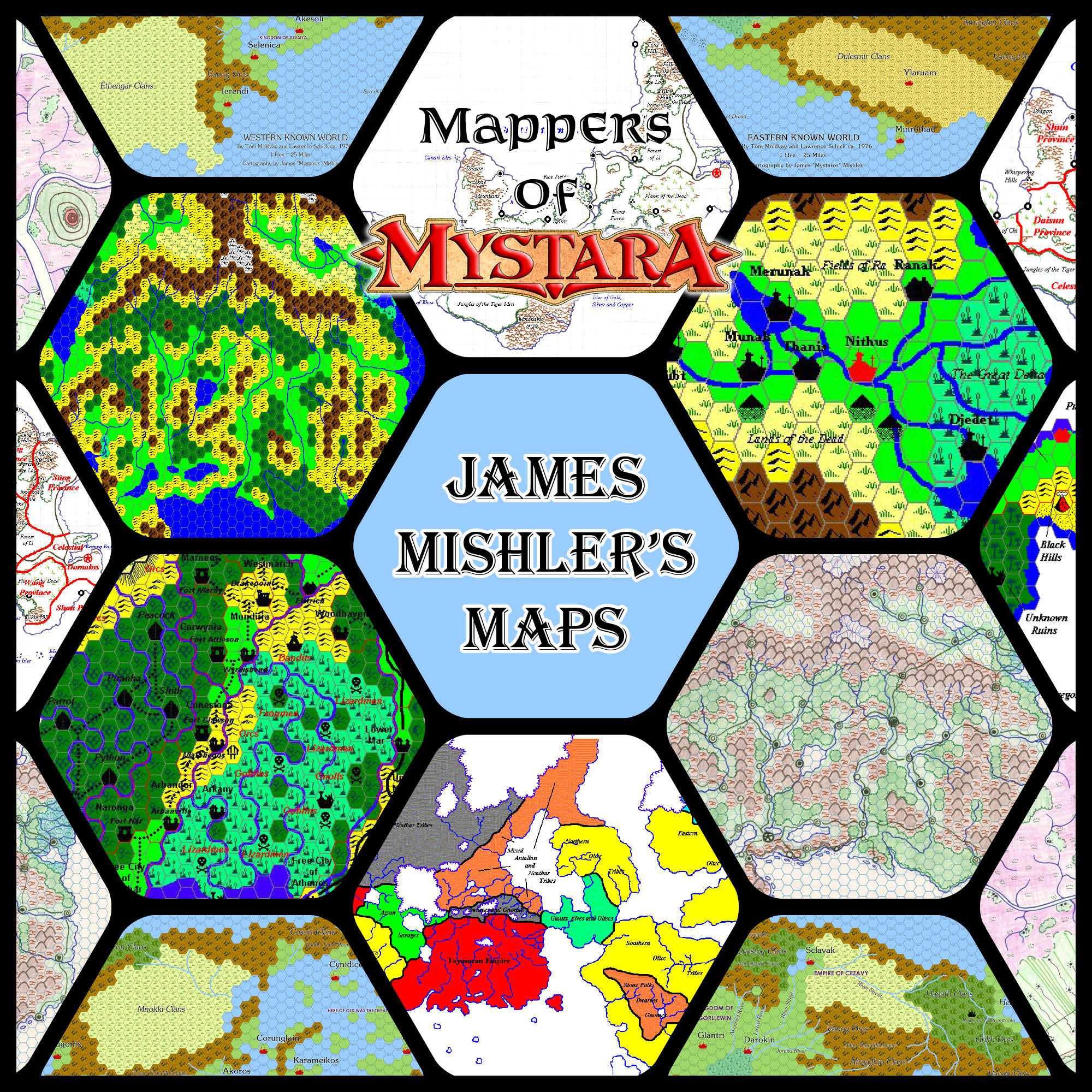
A member of the Mystara online community from its earliest days, James has contributed an incredible wealth of material to the setting. He is a prolific designer, and nowadays a published RPG designer to boot. While his main Mystaran legacy is undoubtedly his articles, he also created some highly significant maps whose lasting influence can still be felt today.
Profile
- Nickname: Mystaros (Vaults author page, Piazza profile, Company site, Personal blog, DriveThruRPG products)
- Location: Wisconsin, USA
- Maps Posted: 1998-1999, 2003, 2005, 2015, 2019
- Areas of Interest: Known World, especially Karameikos
- Scales: 24 miles per hex, 8 miles per hex
- First Posted Map: Ancient Nithian Empire, 24 miles per hex (July 1998)
- Software: Various — hand-drawn, Andrew Theisen’s Mapping System, Hexographer
- Mapping Style: Various, depending on the map
- Fonts: Times, Algerian D, Arial
Overview
Under the nickname of Mystaros, James Mishler has been a part of Mystara’s online community since time immemorial. Uh, well, that is, at least since 1995, and the beginnings of the Internet. Back then, Mystara’s home on the web was limited to TSR’s message boards on AOL. James was a frequent poster there, interacting with other fans as well as TSR staff.
Mystara AOL and the netMAGs
Always a prolific writer and designer, he posted various glimpses into his developments for Mystara — many of which were preserved in Brant Guillory’s Mystara netMAG series; James was a regular contributor from netMAG 3 until the last issue, netMAG 8. The topics he chose to write about are an eclectic mix, and yet many of his later interests were already present: Taymor, the Thanegioth Archipelago, Kaarjala, and a focus on populations, migrations, and their languages. All of this and more from this time can be seen and enjoyed at the Vaults of Pandius.
It seems like ancient history now, but back in those early days, Mystara was still (barely) in print, Red Steel was just appearing (before being rebranded to Savage Coast), and Bruce Heard was still working at TSR — which was still functioning, with the Wizards of the Coast buyout and rescue yet to happen.
Thanks to that climate, reading the old chat logs is quite informative, as at first there is still talk of possible products to come, as well as real time reactions to Mystara’s cancellation, and so on. One such discussion was about possible future trail maps, about which James speculated as follows:
If my calculations are correct, each of the trail maps covers approximately 700 miles from east to west; if the new maps would be a continuation of the old maps to the west (i.e., Sind and the Great Waste), 2 maps would cover an area from around the eastern end of the territories of the Atruaghin Clans (which were not portrayed in the original trail maps) to a point just east of the territory claimed by Slagovich. 3 more maps focused on the Savage Coast would cover the area from just east of Slagovich nearly to The Horn, not quite including the entirity of Orc’s Head Peninsula. The breakdown: 1st map is from east of Slagovich to just west of Estado de Guadalante; the 2nd map then covers the area to the border between Renardy and Bellayne; and the 3rd to The Horn. A fourth map would cover the area from The Horn to about the middle of the mountains dominating the Arm of the Immortals. Altogether, 6 new maps to cover the entire area, not including the parts north and south (because of the near “marginal” material, there is some play in this area; however, almost all of the Serpent Peninsula would be out of the picture). This would not be a terrible problem, as the map could be dropped down a few hundred miles south, as much of the region north of the Savage Coast and Sind is, as yet, underdeveloped in an “official” manner.
Another inquiry regarding Trail Maps: Would it ever be possible that the Isle of Alphatia would be developed on such a scale?
James Mishler, “Re: Trail Maps”, 21st August 1995, Mystara AOL Message Board
Unfortunately trail maps as a product were never a success, due to unforeseen costs — the folding process was ridiculously expensive, and remains a barrier to printing such maps to this day — and none of this has come to pass. On the other hand, in terms of the maps themselves, what James outlined back then, more than 25 years ago, remains a tantalising dream, and one that this site still aims to deliver on in the near future.
The Heyday of the Mystara Mailing List
From 1997, James moved his focus to the burgeoning Mystara Mailing List. While AOL was a closed garden, limited to AOL subscribers, the MML was open to all comers. Due to the popularity of BECMI outside of the US, a relatively large portion of Mystara’s fan base was (and still is) made up of international members: people from the UK, Italy, France, Germany, Australia, Ireland, Spain, Mexico, Brazil, and many other countries; people who grew up with the Red Box and the Gazetteers, and never saw AD&D as a step upwards, if it was even available at all in their language.
This was truly the heyday of the MML, and James was a great contributor. Aside from his writing, he also began to post maps to his site, giving his design a new and exciting aspect, which of course is our primary interest here at the Atlas. The first of these was Ancient Nithia, done in Andrew Theisen’s hex mapping system in MS Paint. In fact, James had long been drawing his own maps, but he nevertheless chose to post mostly digital maps.

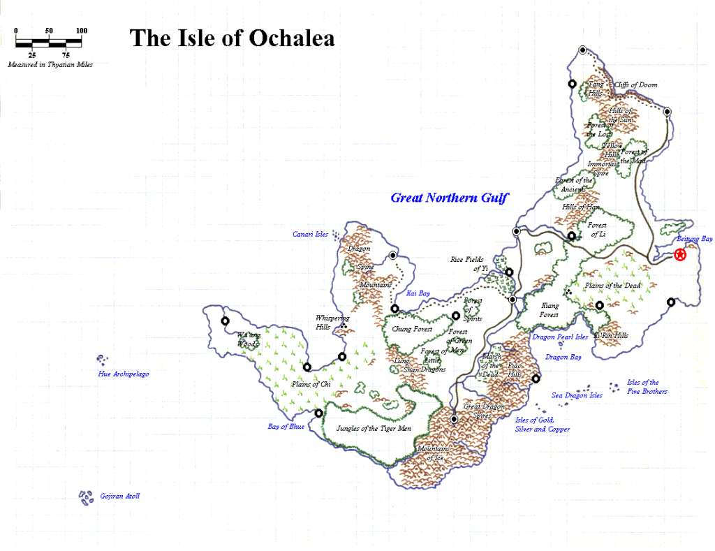
An exception to this came next in the form of his political and geographic maps of Ochalea, which used his hand-drawn map as a backdrop to enhance with digital labelling and other markups. As with Nithia, there was a clear link between what he was designing and the maps he drew. This may seem obvious, but to me it’s the sign of a true designer, with feet in both the writing and production/cartography sides.
The MML was all about discussion, of course, and James never shied away from controversial topics, as you can see from this wonderful quotation:
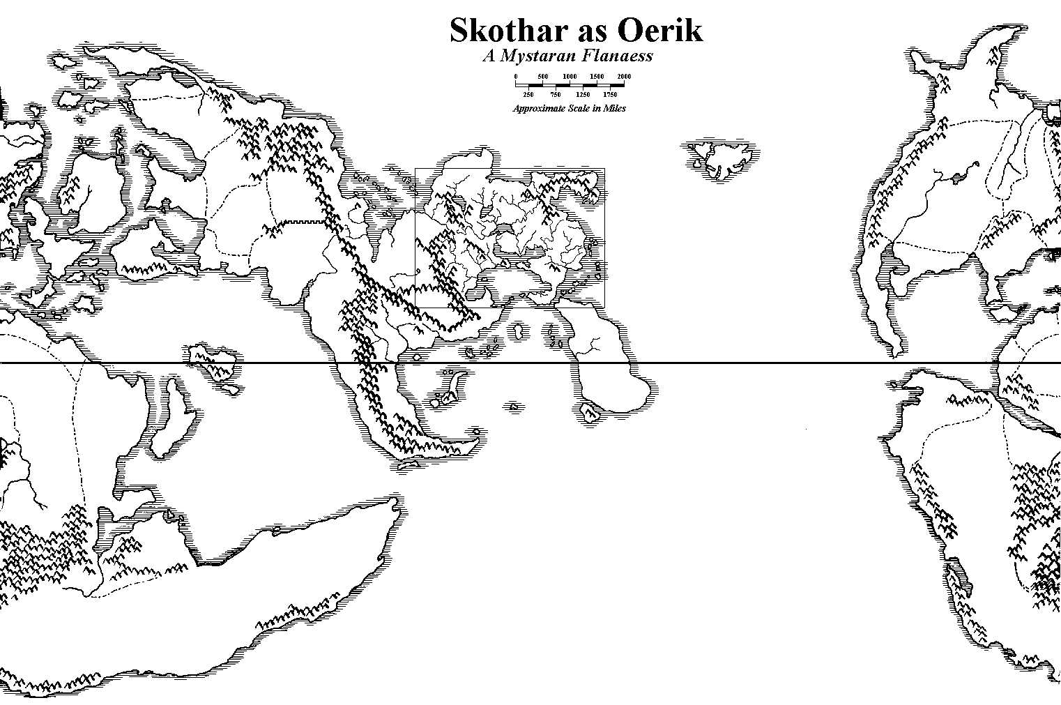
Hmmm… One thing I have been wondering about lately is where people have been placing Blackmoor, Thonia and the other nations mentioned in the DA series. I always thought that Blackmoor and Thonia were clearly placed on Skothar according to the HW world maps (though Blackmoor and Thonia were reversed, see below). I’ve heard of people placing Blackmoor on Brun, but never on Davania. What is the general concensus in the Mystara list, if there is such a thing. 🙂
James Mishler, “Re: Arica”, 27th April 1997, Mystara Mailing List
In fact, I had my own clashes with him, and I must say, reading them again almost 25 years later, I am somewhat aghast at what a jerk I was back then! Sorry about that, James. 😉
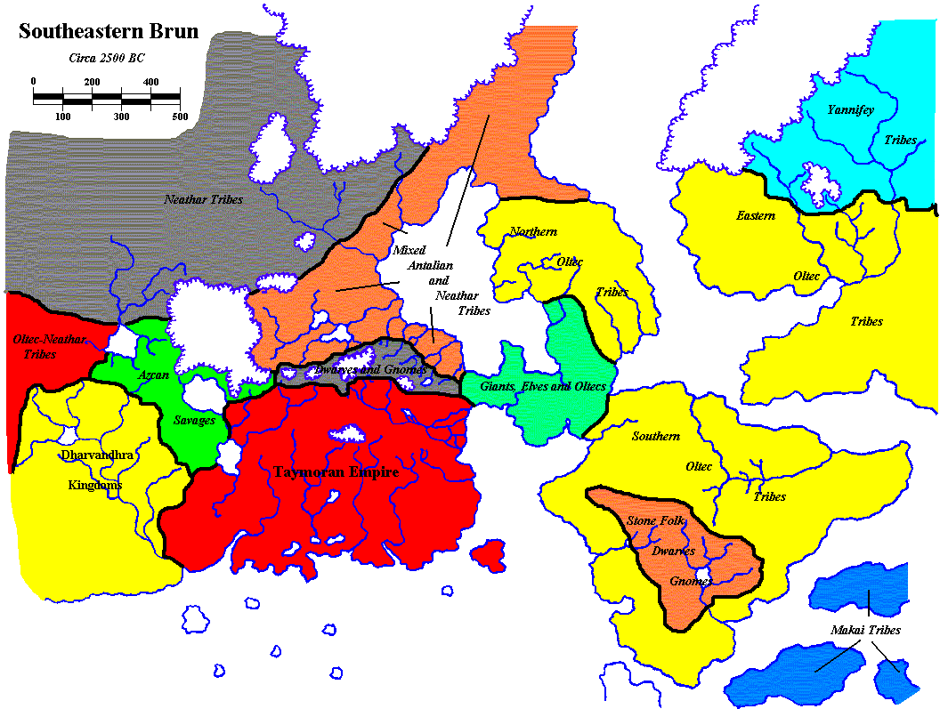
Other highlights of his MML years were Southeastern Brun in the era of ancient Taymora, his take on the Malpheggi Swamp in the Westerlands campaign, and Nueva Ispañola in the Thanegioth Archipelago. All of these went on to influence later fan productions.
Later Years
After activity on the MML died down, James spent many years pursuing his career as a professional game designer, posting less about Mystara. Indeed, his Mystara work of that time — revised versions of Atruaghin and Karameikos — remained private for many years, and is only now coming to light.
More recently, he has returned to Mystara on his blog. In 2015, when Lawrence Schick posted his fascinating story of the Original Known World map, it was James who lovingly recreated Moldvay and Schick’s original map, and interviewed Lawrence to make it the best it could be.
After that, he posted a few scans of old hand-drawn maps — lost treasures, if you will, that I am always very thankful to see.
And most recently he returned to Karameikos in 2019 to detail a new development in the Altan Tepe Mountains around Castellan Keep, which he named Tepeshiya.
Consistent throughout all of James’s work over the years is his eternally burning love for Mystara. I look forward to seeing what he comes up with in the future.
Interview
James graciously agreed to answer some questions for this article.
How did you first get interested in Mystara?
I received the Moldvay Basic Set for Christmas in 1981, and within two months had picked up the Cook/Marsh Expert Set, the Dungeon Master’s Guide, and modules B1 In Search of the Unknown and T1 The Village of Hommlet, because I was hooked! The Basic Set had B2 Keep on the Borderlands, and the Expert Set had module X1 Isle of Dread, which of course had the Continental Map, and the Expert rule book had the 6-mile per hex map of Karameikos.
I immediately started using that Karameikos map for my first adventures, the very basic beginnings of a campaign.
There being no central settlement along the unnamed main river for a home base, I placed my own – “Geneva”– just north of where Kelvin was eventually placed on the map, using Hommlet as the map for the locale (as “Hommlet” was in Greyhawk, naturally I had to change the name).
The Keep on the Borderlands and the Caves of Chaos were placed north of that, close to where Threshold would later be placed (to protect the Gnomes from the monsters of the Lost Valley, the caves being merely their forward outpost).
From Geneva and the Keep the adventurers delved into the ruined gnome lair, Quasqueton, the Caves of Chaos, and the ruined moat house, though they never got to the haunted keep, Krakatos, or Specularum (too far south).
In my original campaign, Karameikos had been a part of the Thyatian Empire, but fell into chaos and anarchy when the western portion of the empire was invaded by humanoids from the Broken Lands (as had the whole continent at the time). The humanoids were most successful there, though, and civilization fell.
A century later (the campaign timeframe), the land is being re-settled and re-claimed by peoples from Thyatis, Darokin, the Five Shires, Ierendi, Minrothad, and even Ylaruam, under the mysterious “Grand Duke,” Stephan Karameikos, whose claim to the land is precarious at best (Thyatis is a crumbing empire in this version of the setting, and can do little more than bluster at the insult).
[I should note, once I got access to it in 1983, I used the City State of the Invincible Overlord as Specularum, and the “Grand Duke” was also known as the “Invincible Overlord”; I used Viridistan for the City of Thyatis.]
What draws you to the setting?
Some of the best things about the Known World are its cultures; its size; and its wide-open nature.
Even before the Gazetteer series, from the names and the description of the continent in X1, you knew you had a whole ton of neat historical cultures jammed together in a relatively small area. Some call this a bug; I call it a feature. So many great adventuring ideas to take from history, myth, and legend!
You can get into all sorts of adventures without having to travel across half a continent of wilderness just to have a single adventure (I’m looking at you, Greyhawk). Like my other favorite setting, the Wilderlands, you can adventure from town to town, village to village even hex to hex, and something new and different might be just around the corner.
But, even with the historical cultural background, it is still wide open, wild and wooly, as it inherited that aspect from the B/X system, which inherited it from the OD&D system, and did not get reined in by the AD&D system and the campaign assumptions of that edition.
It is a true fantasy world with a veneer of historical sensibilities.
Did you have a favourite official map?
I’ve always loved the original Continental Map included with X1. It showed the whole Known World region plus the Sea of Dread. All the add-on regions were nice, but none ever had the huge potential for adventure as did that one single map.
When did you start mapping Mystara?
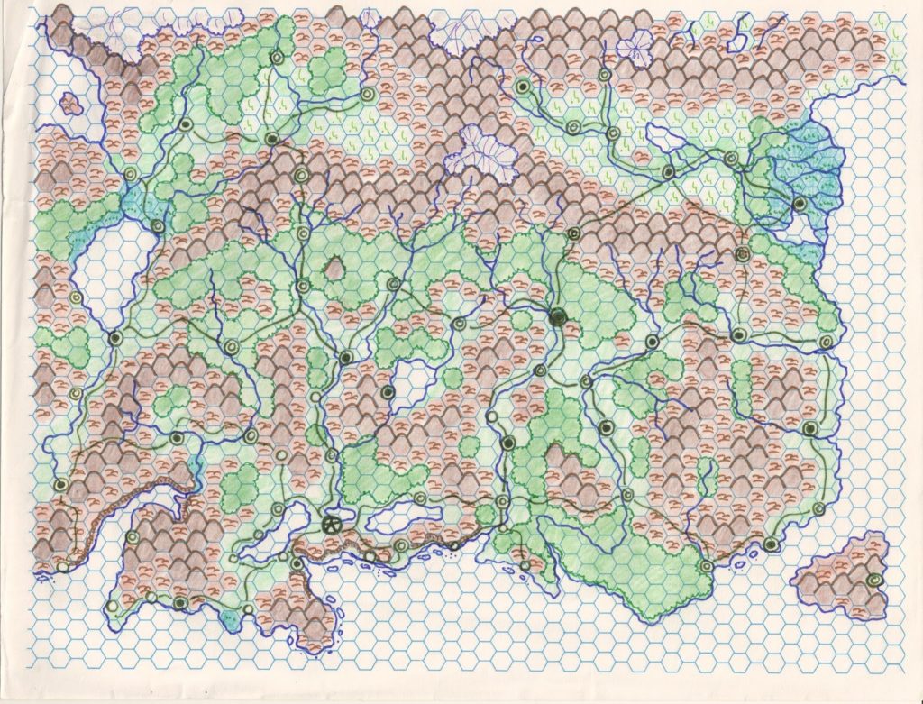
Almost immediately, if you count modifying the maps to meet campaign needs, as I did with the Karameikos map. But as this was 1982, materials to make maps were few and far between, even if I had any idea of how to begin. I started running campaigns in the Wilderlands, my second campaign setting, ca. 1983, when introduced to the setting via my high school game club. I finally got and used the 25-hex across blank hexes from Judges Guild’s Campaign Hexagon System to detail the 6-mile hexes. I just used the map blanks with the 6-mile hexes as the Wilderlands used it with the 5-mile hexes and called it good. None of those maps survive, lost long, long ago…
All that 6-mile hex work went to the wayside when TSR released GAZ1 The Grand Duchy of Karameikos, using the new 8-mile hex designs adapted from designs used in DA1 Blackmoor, published the year before, themselves adapted from the hex designs provided in the Cook/Marsh Expert Set. After that I adapted to the 8-mile hex, but my campaign went to the wayside as I spent a year in Germany and then started college.
I finally got some Armory 8.5” x 11” hex sheets, and re-drew the main map and the connecting maps by hand to put them together in one huge map, cut and taped together. It had the Known World, Sea of Dread, Wendar, Norwold, Great Waste, Hule, Serpent Peninsula, and Southold, mostly per the original maps but with my own additions here and there (the Broken Lands were more detailed, and more like Mordor than what was later developed in Mystara). This was a process that took years (ca. 1988 to 1990) as I got the time to draw the maps, and you could actually see how my skill developed from map to map! Sadly, that map is also long since gone, literally having fallen apart through many moves and much use.
When and where did you post your first map online?
To be honest, I really do not remember which was the first map I posted. I think it was the Nithia map? It would have been through the AOL Mystara Message Board, no sooner than 1995, as that is when I first seriously got into the online gaming presence (I remember that distinctly as I was living in Seattle at the time).
What software did/do you use? Or did/do you draw your maps by hand?
At first it was all hand-drawn.
Then I used some hexes (I think they were from Andrew Theisen?) and stitched stuff together in Paint (Nithia, Westerlands, etc.).
Finally, I got Hexographer, which is the sweetest program you can find for designing classic Mystara maps. I used to draw a lot of maps by hand, but as I get older, I haven’t the patience anymore to draw when I can use the computer to do it that much quicker and cleaner!
What were/are the limitations or peculiarities of that software?
For drawing Mystara-style maps, none, really. I love Hexographer!
When I get a new computer, I plan on upgrading to the next iteration, Worldographer; it has more bells and whistles.
Please describe your process in brief.
These days with Mystara if I am drawing a map, it will invariably be a “child map,” and so what I usually do is draw the portion of the big map I wish to use in Hexographer, then use the program to blow that up to the scale I want. So when I most recently drew a portion of the Altan Tepes at 8-miles, I took the section of the region I wanted from the 24-mile hex map, drew that in Hexographer, then blew it up into a “child-map” at 8-miles per hex.
I then restyle the topography to fit the natural flow of rivers, valleys, ridges, etc., and from there I place settlements, strongholds, ruins, remnants, lairs, and so forth as I feel it fits the geography and history of the locale. I’ve used a variety of randomizer systems to add randomness to the process, usually derived from Moldvay’s original dungeon stocking chart on p. B52.
It is not so much a science as it is an art.
I’m actually in the process of creating a procedural method to generate the topography, settlements, strongholds, ruins, remnants, lairs, and so forth, in a hex, based on my experiences with developing campaign settings, inspired by systems going all the way back to the works of Dave Arneson.
What challenges did you face during your mapping projects?
Originally, the limitations of my creativity, artistic ability, and time; now it is mostly just finding time, as I have more ideas than I could ever express, and Hexographer takes care of the rest. I have designed and developed so many maps now, it seems to come as natural as breathing. So creatively, unless I am in some doldrum, I have no problems. The problems come when I have too much I want to express, whether in writing or cartography, and I do not have the time…
But until Hexographer? Hoo-boy, stitching together those hex maps in Paint, one hex at a time, and making everything match up and fit… that was a pain. But even then, it was a great advancement on what we had before, which was nothing…
What was your favourite area to work on?
Known World, Karameikos, hands-down. It has always been my favorite region in Mystara. You can do so much with Karameikos; the re-skinned “Normans vs. Saxons” in the Gazetteer series is only one of the many, many ways that you can develop that region.
Lots of wilderness, lots of geographic variety – seas to mountains, deep forests, marshes, hills, lost valleys – even desert lands on the other side of the mountains, which themselves have glaciers! Great mapping opportunities, great adventure opportunities.
Do you have any future plans for your maps of Mystara?
I hope Wizards eventually opens up Mystara for third-party publishing on DM’s Guild; I will rebuild that Karameikos and the Known World from scratch assuming 25-mile hexes on the Continental map and breaking that down to 5-mile hexes for Regional maps.
What are you doing these days?
As I mentioned above I am working on a procedural system for designing hex maps; this is a spin-off of my current work on a new High Fantasy campaign setting for Labyrinth Lord that I hope to have published in a few months.
My recent products through James Mishler Games – Expanded Dragons, the Necromancer Class, Runemaster Class, and upcoming Bard Class – have all been spun off from this work as well. That’s how my creative process goes these days, which is why it takes forever for me to bring out a big product.
You can keep up with my work on my company blog at https://jamesmishlergames.blogspot.com and on my personal blog at https://adventuresingaming2.blogspot.com.
James Mishler’s Maps
| Name | Vaults URL/Filename | Year | M | D | Date Source | Scale |
|---|---|---|---|---|---|---|
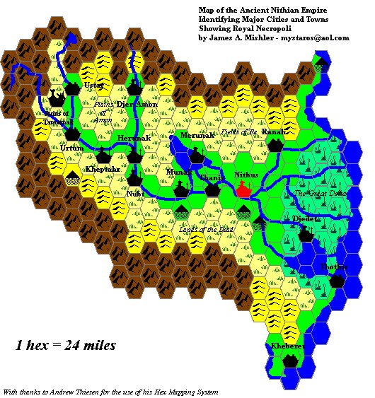
| Ancient Nithian Empire | anc_nith.jpg | 1998 | 6 | 25 | Vaults | 24 |
| The Isle of Ochalea (geographical) | MY OCH Ochalea.gif | 1998 | 9 | 30 | Web Site | Non-hex |
| The Isle of Ochalea (political) | MY OCH Politique.gif | 1998 | 9 | 30 | Web Site | Non-hex |
| Skothar as Oerik — A Mystaran Flanaess | mystghmp.jpg | 1998 | 12 | 14 | Web Site | Non-hex |
| Southeastern Brun circa 2500 BC | 2500bcp.gif | 1999 | 1 | 19 | Web Site | 24 |
| Taymora | taymgeo.gif | 1999 | 3 | 12 | Web Site | 24 |
| Condado Grande de Nueva Ispañola | 1999 | 10 | 29 | Web Site | 8 | |
| The Westerlands Campaign | 2003 | 2 | 8 | Vaults | 8 | |
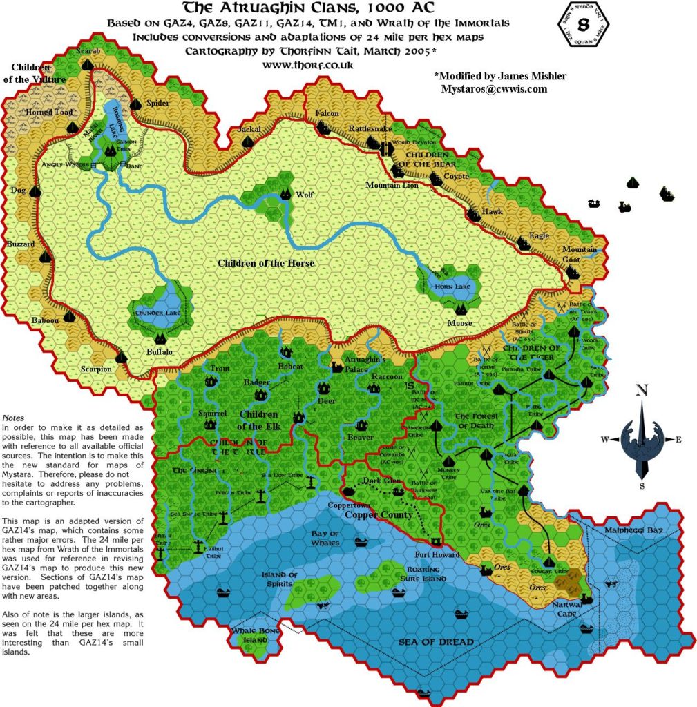
| The Atruaghin Clans, 1000 AC | TA Mod JAM.JPG | 2005 | 3 | 26 | 8 | |
| The Archduchy of Karameikos, 1001 AC | Karameikos Mod.TIF | 2005 | 5 | 23 | 8 | |
| Taymor | Mystara Taymor0001.jpg | 2015 | 8 | 31 | Blog | 24 |
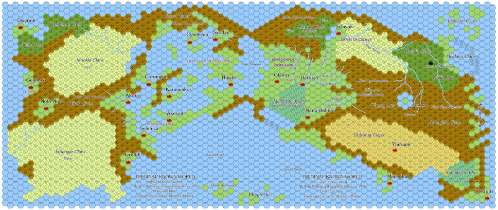
| Original Known World | OKR 03 Combined.png | 2015 | 3 | 2 | Blog | |
| Altan Tepes Castellan Snippet | Altan Tepes Castellan Snippet.png | 2019 | 9 | 1 | Blog | 8 |
| Altan Tepes Region Snippet | Altan Tepes Region Snippet.png | 2019 | 9 | 2 | Blog | 8 |
| Tepeshiya 8 miles per hex | Tepeshiya 8mph Test 01.png | 2019 | 9 | 3 | Blog | 8 |
| Tepeshiya 24 miles per hex | Tepeshiya 24mph.png | 2019 | 9 | 2 | Blog | 24 |
Gallery


Sources
In researching this article, I searched out all the references I could find, and consulted with everyone I could track down. I have made every effort to ensure that the information is accurate, but in some cases I may have slipped up — especially when dealing with maps that are years or even decades old. I take full responsibility for any mistakes; please don’t hesitate to point these out if you find them! Following is a summary of my sources for your reference.
- Direct messaging with James Mishler
- Mystara AOL Message Board Archive
- Mystara netMAG Archive
- Mystara Mailing List Archive
- Mystara Message Board Archive