
LoZompatore’s Dravish Civilization v2
This map was an update to Michele’s Dravish map from 2006. While it’s not clear where (or whether) he posted that one, that is not the case with this one: he posted it at The Piazza in May 2008, when the site was brand new — just days old, in fact.
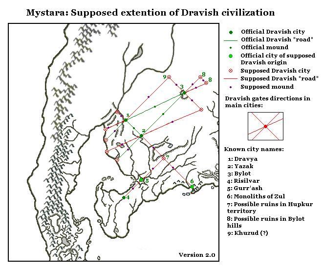
Version 2.0 has only one major change: Michele cut the red geometrical lines at the coast of Yalu Bay rather than extending them across the water. This resulted in two new “supposed Dravish cities” on the coast.
More of a point, this version was part of an extended article at The Piazza (and archived at the Vaults of Pandius) explaining the concept behind the map in detail. In his article, Michele collected all of the relevant quotations from the sources, and then extrapolated some extra details to go with them.
This is one of only a few works on Dravya to date. Years later, Michele’s maps and article inspired Matthew Fleet when he created his own maps of the area, culminating in an article in Threshold Magazine.
Fan-made Map by Michele Carpita (May 2008)
This is an original map created by one of Mystara’s excellent fan cartographers. For more information on the cartographer, including a gallery of all their maps, see also Appendix M: Mappers of Mystara.
Sources
- Tortles of the Purple Sage — Part 1, Dungeon #6 (July 1987)
- Tortles of the Purple Sage — Part 2, Dungeon #7 (September 1987)
Fan Sources
- The Dravish civilization discussion thread at The Piazza (originally May-June 2008)
- The Dravish Civilisation by Michele Carpita at the Vaults of Pandius (May 2008)
References
- All of Michele’s maps at the Atlas of Mystara
- Michele’s entry in Appendix M: Mappers of Mystara (upcoming)
- Michele’s author page at the Vaults of Pandius
Chronological Analysis
This is a fan-made map. It was published in May 2008. The updated Atlas version of this map is not yet available. See also Appendix C for annual chronological snapshots of the area. For the full context of this map in Mystara’s publication history, see the upcoming Let’s Map Mystara 2008.
The following lists are from the Let’s Map Mystara project. Additions are new features, introduced in this map. Revisions are changes to previously-introduced features. Hex Art & Fonts track design elements. Finally, Textual Additions are potential features found in the related text. In most cases, the Atlas adopts these textual additions into updated and chronological maps.
Under Construction! Please check back again soon for updates.
Additions
- XXX —
Revisions
- XXX —
Hex Art & Fonts
- Hex Art —
- Fonts —
")
")
")