
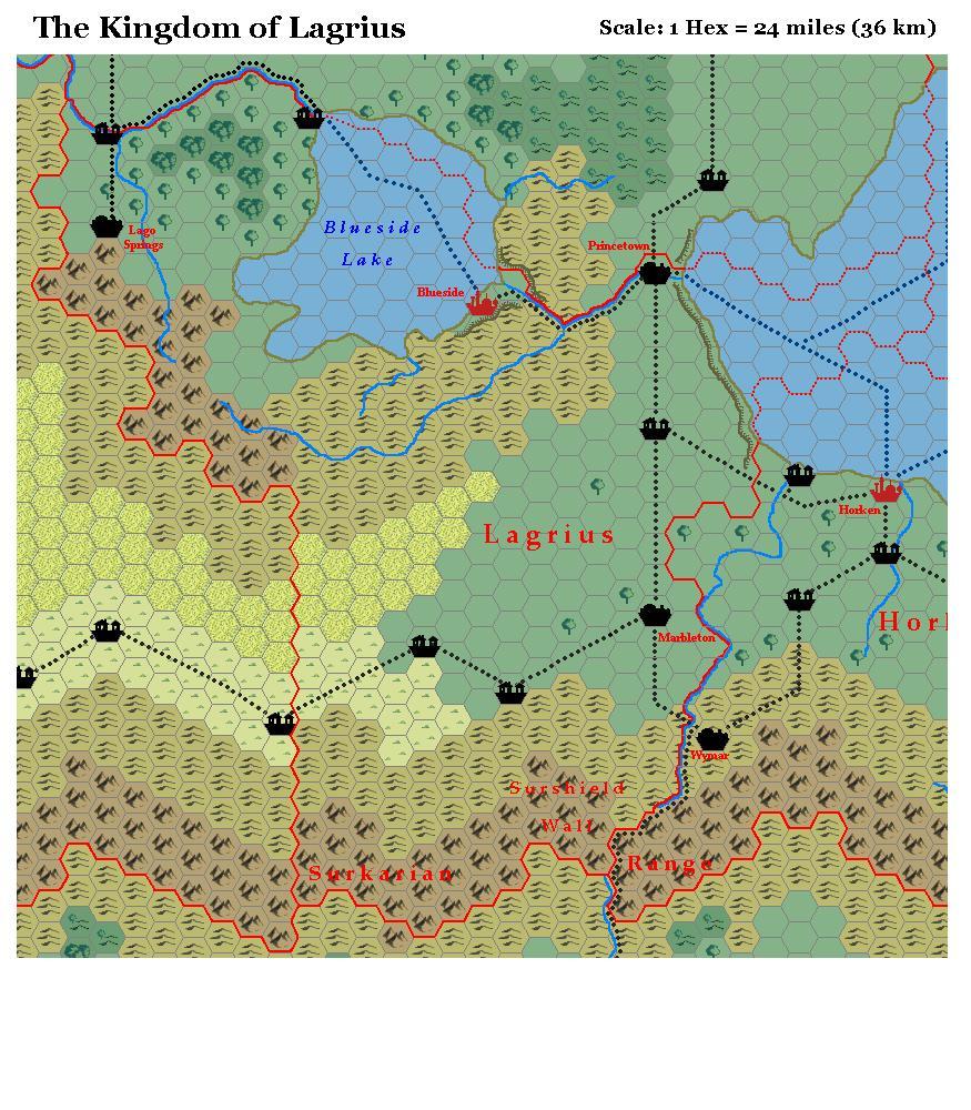
LoZompatore’s Lagrius, 24 miles per hex
Situated to the east of Dawnrim, in the central area of Bellissaria, Lagrius includes part of the arid plain which Michele marked as poor grazing lands. (See his Dawnrim map for more on this.) Once again, I will leave the explanation of changes to Michele, who provided extensive notes on these maps in his original MMB posts:
I changed some plains with the poor grazing lands … for the same reason I explained in Dawnrim entry (the road that cross the steppes instead of the plains).
PWAIII says that Lagrius doesn’t have a true access from the sea. So I supposed that the coastline is very steep, preventing the building of seaport and major harbours. I added an escarpment also on the hills just east of the capital city. That’s because PWAI says that Blueside city is protected by the lake on one side, and by a steep range of hills on the other side.
The river between Blueside and Princetown has maybe dug his way through the higher land, carving a canyon or a deep valley along its route.
I added a village at the end of the trade route that crosses the lake starting from Blueside city.
Fan-made Map by Michele Carpita (July 2006)
This is an original map created by one of Mystara’s excellent fan cartographers. For more information on the cartographer, including a gallery of all their maps, see also Appendix M: Mappers of Mystara.
Sources
- Dawn of the Emperors (1989) (PDF at DriveThruRPG)
- Wrath of the Immortals (1992) (PDF at DriveThruRPG)
- Poor Wizard’s Almanac (1992)
- Poor Wizard’s Almanac III (1994)
Fan Sources
- Thoughts about Bellissarian maps discussion thread at the MMB, archived at the Vaults of Pandius (July 2006)
- Thoughts about Bellissarian maps by Michele Carpita at the Vaults of Pandius (July 2006)
References
- All of Michele’s maps at the Atlas of Mystara
- Michele’s entry in Appendix M: Mappers of Mystara (upcoming)
- Michele’s author page at the Vaults of Pandius
Chronological Analysis
This is a fan-made map. It was published in July 2006. The updated Atlas version of this map is not yet available. See also Appendix C for annual chronological snapshots of the area. For the full context of this map in Mystara’s publication history, see the upcoming Let’s Map Mystara 2006.
The following lists are from the Let’s Map Mystara project. Additions are new features, introduced in this map. Revisions are changes to previously-introduced features. Hex Art & Fonts track design elements. Finally, Textual Additions are potential features found in the related text. In most cases, the Atlas adopts these textual additions into updated and chronological maps.
Under Construction! Please check back again soon for updates.
Additions
- XXX —
Revisions
- XXX —
Hex Art & Fonts
- Hex Art —
- Fonts —
")
")
")