
LoZompatore’s Alphatia, 24 miles per hex Tidal Wave
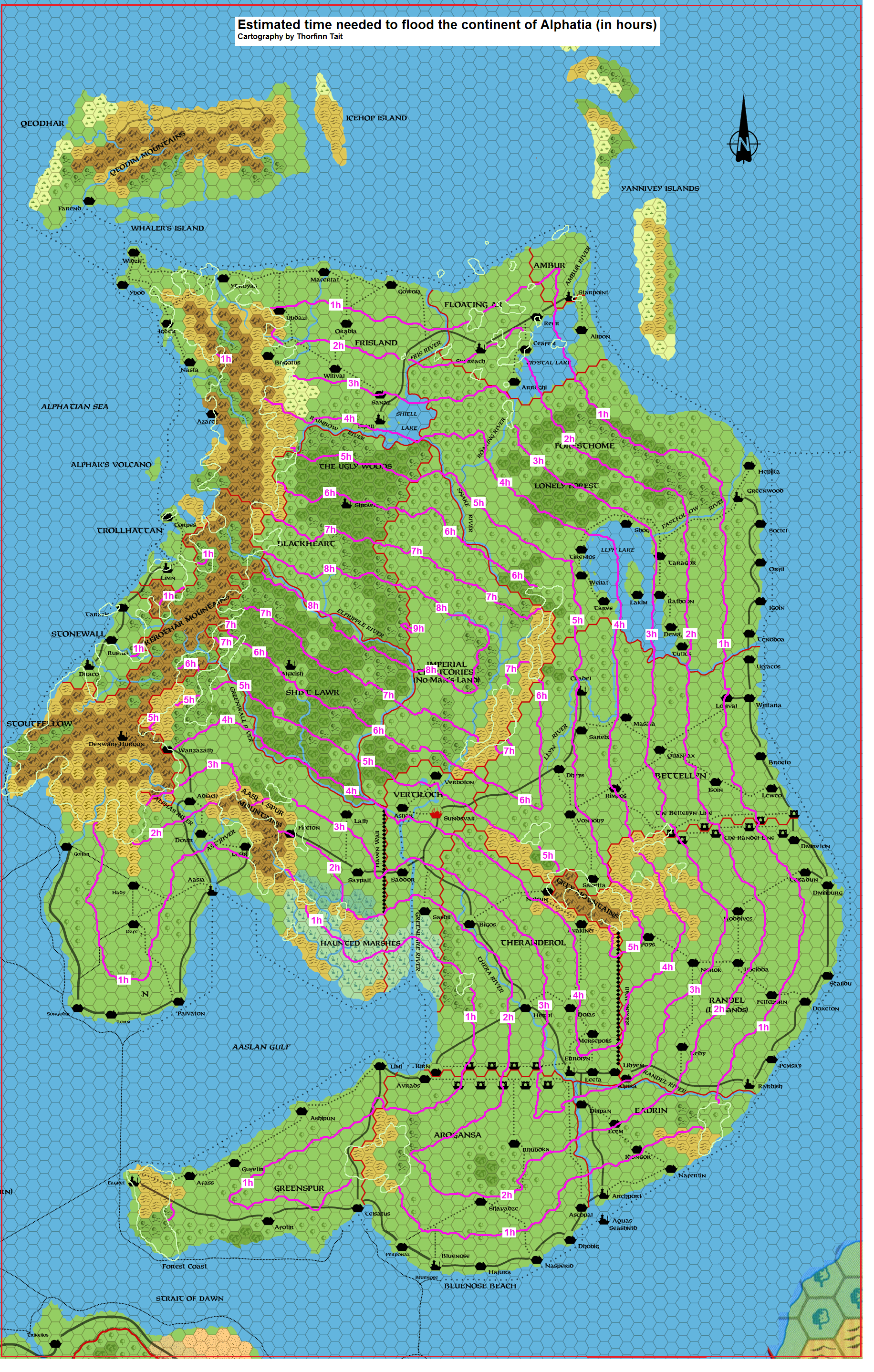
Using my replica of Dawn of the Emperors’s Alphatia, 24 miles per hex, Michele created this map as a thought experiment: how fast would Alphatia be flooded by a tidal wave as (or after) it sank? Referencing the speed of a tidal wave from real world data, he extrapolated that it could move as fast as 72 miles per hour, flooding three hexes on this map each hour. Using this figure, he then traced contour lines showing the land that would be flooded each hour of the catastrophe.
Finally, he referenced post-sinking maps to show the high ground that would be left over, marking it on the map in outline form.
The resulting map formed a basis for a reimagining of the results of Wrath of the Immortals based on this new information. Namely, the idea is that there would have been time to evacuate — especially for the inland areas that lay far from the sea.
Michele followed this up with a new map, adapting the officially-presented view of post-sinking Alphatia to this new idea of evacuation and survivors.
Fan-made Map by Michele Carpita (October 2010)
This is an original map created by one of Mystara’s excellent fan cartographers. For more information on the cartographer, including a gallery of all their maps, see also Appendix M: Mappers of Mystara.
Sources
- Dawn of the Emperors (1989) (PDF at DriveThruRPG)
Fan Sources
- Settlements of the New Alphatian Sea (a what-if scenario) discussion thread at The Piazza (October 2010)
References
- All of Michele’s maps at the Atlas of Mystara
- Michele’s entry in Appendix M: Mappers of Mystara (upcoming)
- Michele’s author page at the Vaults of Pandius
Chronological Analysis
This is a fan-made map. It was published in October 2010. The updated Atlas version of this map is not yet available. See also Appendix C for annual chronological snapshots of the area. For the full context of this map in Mystara’s publication history, see the upcoming Let’s Map Mystara 2010.
The following lists are from the Let’s Map Mystara project. Additions are new features, introduced in this map. Revisions are changes to previously-introduced features. Hex Art & Fonts track design elements. Finally, Textual Additions are potential features found in the related text. In most cases, the Atlas adopts these textual additions into updated and chronological maps.
Under Construction! Please check back again soon for updates.
Additions
- XXX —
Revisions
- XXX —
Hex Art & Fonts
- Hex Art —
- Fonts —
")
")
")