
Ramelin’s Kavkaz, 8 miles per hex
Although the map says 2015 in its corner, Jose shared it on his Pinterest in January 2016. The file dates to the day after he completed his Northeastern Brun v2 map, which included the top right two thirds of this map. The left and bottom portions of this map appeared here for the first time.
As far as I am aware, this was the first ever 8 mile per hex map of the Kavkaz region. It originated in 1999 with Christian Constantin’s 24 mile per hex map of Hule and its surroundings, and although it appeared in various other maps over the years, no one tackled it at this scale until Jose. Therefore, the entire conversion from 24 to 8 miles per hex, including all the new settlements (primarily all the villages) is Jose’s work. He adopted most of Christian’s town and city names, though for reasons unknown some were entirely different, while others had variant spellings — perhaps typos, perhaps intentional. There’s no way to tell.
In any case, it’s a beautifully detailed map, doing great service to one of our community’s oldest fan creations.
Fan-made Map by Jose Ignacio Ramos Lomelin (January 2016)
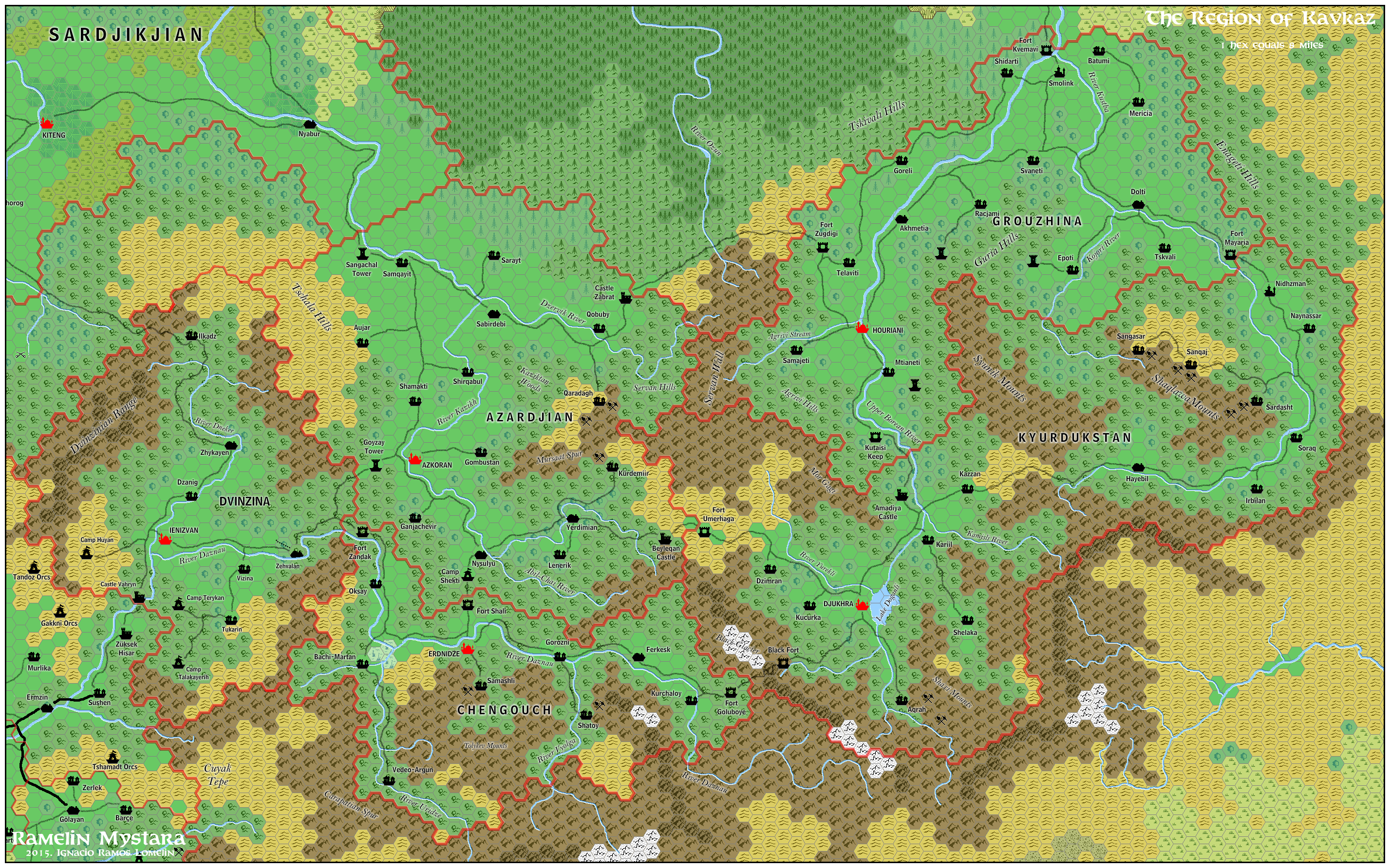
This is an original map created by one of Mystara’s excellent fan cartographers. For more information on the cartographer, including a gallery of all their maps, see also Appendix M: Mappers of Mystara.
Sources
- X4 Master of the Desert Nomads (1983) (PDF at DriveThruRPG)
- Champions of Mystara (1993) (PDF at DriveThruRPG)
Fan Sources
- Christian’s Hule, 24 miles per hex (May 1999)
- Thibault’s Hule, 24 miles per hex (April 2001)
- Christian’s Central Brun, 24 miles per hex (October 2014)
References
- All of Jose’s maps at the Atlas of Mystara
- Jose’s entry in Appendix M: Mappers of Mystara (upcoming)
- Jose’s author page at the Vaults of Pandius
Chronological Analysis
This is a fan-made map. It was published in January 2016. The updated Atlas version of this map is not yet available. See also Appendix C for annual chronological snapshots of the area. For the full context of this map in Mystara’s publication history, see the upcoming Let’s Map Mystara 2016.
The following lists are from the Let’s Map Mystara project. Additions are new features, introduced in this map. Revisions are changes to previously-introduced features. Hex Art & Fonts track design elements. Finally, Textual Additions are potential features found in the related text. In most cases, the Atlas adopts these textual additions into updated and chronological maps.
Coming Soon
")
")
