
Thibault’s Traladara, 8 miles per hex 960 AC
Here’s an interesting little thing: pre-Karameikos Traladara, 10 years before Stefan Karameikos would arrive to claim it. The file is dated February 2001. It seems clear that Thibault made it around the time of the file’s date, but I haven’t been able to track down where it might have been posted. Nor have I discovered a matching numbered key.
What does seem clear is that it isn’t hugely different to 1000 AC maps in terms of settlements — mostly they are simply smaller than their present-day versions, and likely at least some will have different names, too.
If anyone has any more information on this map, please post it in the comments below.
Edit (2025/4/26): I discovered a post to the MML on this topic by Mike Harvey. It’s on the same topic, has the same filename, the same date, and it includes a key, which I will include below. Mike explains a little about the map:
Traladara is Thyatian-occupied. A governor and garrison are in Mirros (Specularum), but other than taxes the rest of the country is ruled by Traladaran lords, with little or no Thyatian presence. Most of the Traladaran lords are small holders, with 55 sq miles or less (one 8-mile hex).
Fan-made Map by Thibault Sarlat (February 2001)
Key by Mike Harvey (February 2001)
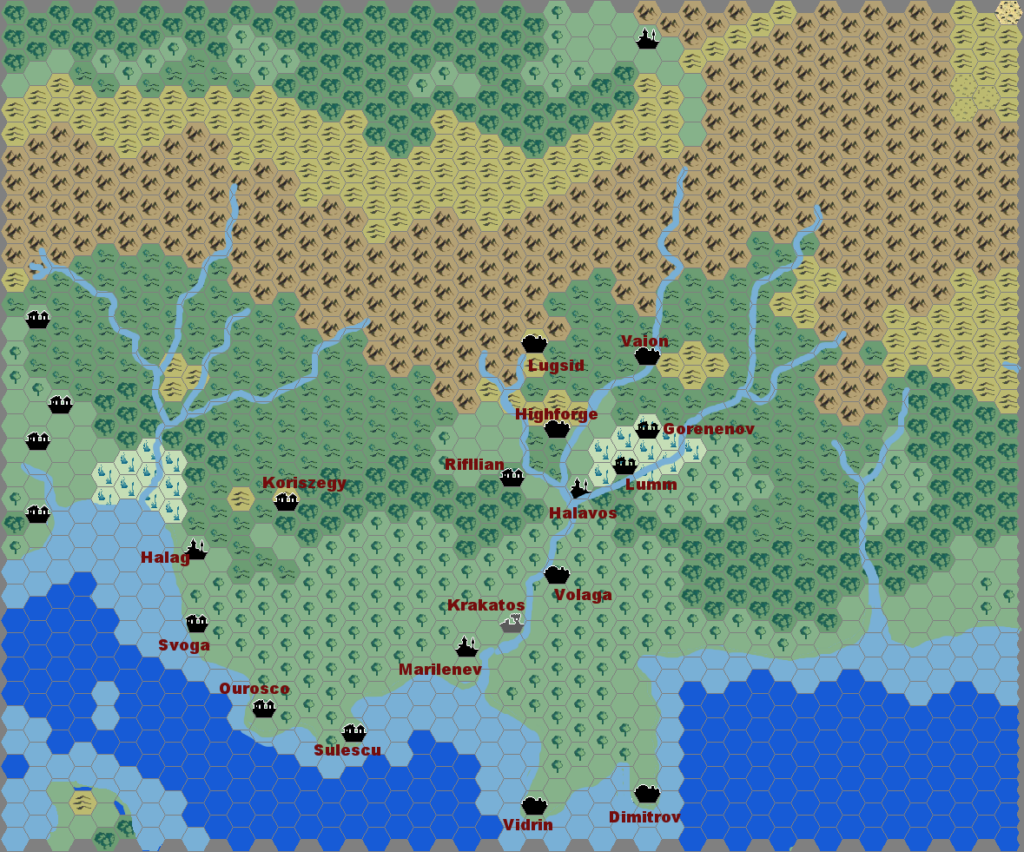
- Achelos
- Luln; Koriszegy to the east
- Halag
- Darinov
- Ourosco
- Vandevicsny
- Gorenenov (abandoned)
- Sulescu
- Marilenev; Lazkow just southwest
- Mirros (Specularum)
- Vidrin
- Dmitrov
- Brezovo
- Rugalov
- Ruins of Lavv to the north
- Rifflian
- Highforge
- Verg (?)
- Fogor; mysterious ruins north
- Trading village (I haven’t named it yet)
- Armstead (Darokin)
This is an original map created by one of Mystara’s excellent fan cartographers. For more information on the cartographer, including a gallery of all their maps, see also Appendix M: Mappers of Mystara.
Sources
- GAZ1 The Grand Duchy of Karameikos (1987) (PDF at DriveThruRPG)
Fan Sources
References
- All of Thibault’s maps at the Atlas of Mystara
- Thibault’s entry in Appendix M: Mappers of Mystara (upcoming)
- Thibault’s author page at the Vaults of Pandius
Chronological Analysis
This is a fan-made map. It was published in February 2001. The updated Atlas version of this map is not yet available. See also Appendix C for annual chronological snapshots of the area. For the full context of this map in Mystara’s publication history, see the upcoming Let’s Map Mystara 2001.
The following lists are from the Let’s Map Mystara project. Additions are new features, introduced in this map. Revisions are changes to previously-introduced features. Hex Art & Fonts track design elements. Finally, Textual Additions are potential features found in the related text. In most cases, the Atlas adopts these textual additions into updated and chronological maps.
Coming Soon


27 September 2021 @ 10:44 pm
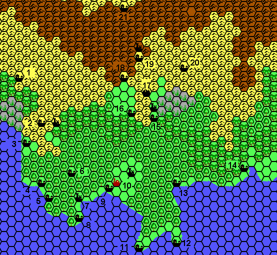
As to the numbered locations , required some puzzling as the scales vary per canon, yet I came to these using Sturm’s Time maps of Karameikos (specifically 12- 960AC)
1=Riverfork Keep (and closeby Gorica)
2=Luln (and 2 hex east Koriszegy Keep /ruin)
3=Halag
4=Svoga
5=Ourosco
6=Corescon(closeby Future Radlebb Keep/Village)
7=a bit displaced to the east and coast, yet this is most probably the ruins of Demiatic, which is actually more west.
8=Sulescu
9=Marlinev
10=Mirros(future Specularum)and 2 hex NE Krakatos Ruin
11=Vorloi
12=Dmitrov
13=Uncertain on this scale it could be Ayla (future Thrakius), Kerosinos
14= Rugalov (and Erroton)
15=Halavos(Future Kelvin)with north Lumn Ruins (which actually are more NE from Kelvin)
16=Rifflian
17=Eveskyr
18=Okrai (future Verge)
19=Lugsid(Future Threshold)and Mistamere Castle Ruins
20=Vaion(future Penhaligon)
21=Armstead