
Agathokles’ Sea of Dread Area
Longtime community member Giampaolo “Agathokles” Agosta has contributed a great deal of material over the past 25+ years. Among his many works there have been a number of maps of a variety of places in and around Mystara.
This is the earliest map that Giampaolo shared. It comes from his web site, where he included it on a page listing the “Lands crossed by the Princess Ark”. It’s a clear adaptation of similar maps that appeared in the original Princess Ark series in Dragon Magazine. However, with his customary attention to detail, Giampaolo meticulously added in the small islands of the Sea of Dread and Serpent Peninsula areas.
The size and resolution of the map show that it’s a product of its era, around the turn of the millennium.
Fan-made Map by Giampaolo Agosta (May 2000)
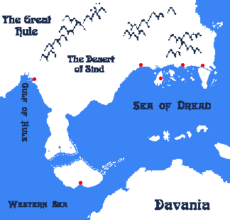
This is an original map created by one of Mystara’s excellent fan cartographers. For more information on the cartographer, including a gallery of all their maps, see also Appendix M: Mappers of Mystara.
Sources
- The Voyage of the Princess Ark series
Fan Sources
- None
References
- All of Giampaolo’s maps at the Atlas of Mystara
- Giampaolo’s entry in Appendix M: Mappers of Mystara (upcoming)
- Giampaolo’s author page at the Vaults of Pandius
Chronological Analysis
This is a fan-made map. It was published in May 2000. The updated Atlas version of this map is not yet available. See also Appendix C for annual chronological snapshots of the area. For the full context of this map in Mystara’s publication history, see the upcoming Let’s Map Mystara 2000. (Please note that it may be some time before the project reaches this point.)
The following lists are from the Let’s Map Mystara project. Additions are new features, introduced in this map. Revisions are changes to previously-introduced features. Hex Art & Fonts track design elements. Finally, Textual Additions are potential features found in the related text. In most cases, the Atlas adopts these textual additions into updated and chronological maps.
Under Construction! Please check back again soon for updates.
Additions
Revisions
Hex Art & Fonts
- Art — Pixel art, without anti-aliasing.
- Fonts — Arnold Boecklin for land labels, Mephisto for sea labels.


