
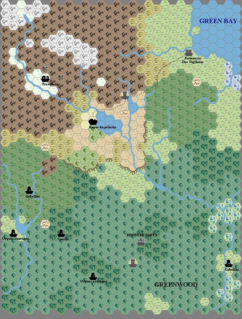
Arkandis’s Vanya’s Rest, 8 miles per hex
In addition to Heldann, 8 miles per hex, I have one other map attributed to Hirwen Hardendal. It was in the same folder in Thibault’s cache of maps, and it also shares the same date stamp on the file. This one, too, clearly deals with the Heldannic Knights, as it shows Vanya’s Rest (in French — Restes de Vanya). The label “Green Bay” places this in south-central Davania.
I consulted our resident Davania expert, Geoff Gander, and he agreed, saying that the area must be southwest of the Vulture Peninsula. He added, “The area just east of the map, on the southern shore, would be the northern slopes of the Diamond Ring.”
The scale seems consistent with an 8 mile per hex map, given the level of detail shown.
I must confess, however, that I’m a bit confused — isn’t Vanya’s Rest supposed to be northwest of the Vulture Peninsula…?
Fan-made Map by Hirwen Harendal (September 2002)
This is an original map created by one of Mystara’s excellent fan cartographers. For more information on the cartographer, including a gallery of all their maps, see also Appendix M: Mappers of Mystara.
The Atlas has been unable to contact the original cartographer. This map therefore appears here without explicit permission from its creator. Any information on how to get in touch with them would be most welcome.
Sources
- ?
Fan Sources
- ?
References
- All of Hirwen’s maps at the Atlas of Mystara
Chronological Analysis
This is a fan-made map. It was published in September 2002. The updated Atlas version of this map is not yet available. See also Appendix C for annual chronological snapshots of the area. For the full context of this map in Mystara’s publication history, see the upcoming Let’s Map Mystara 2002.
The following lists are from the Let’s Map Mystara project. Additions are new features, introduced in this map. Revisions are changes to previously-introduced features. Hex Art & Fonts track design elements. Finally, Textual Additions are potential features found in the related text. In most cases, the Atlas adopts these textual additions into updated and chronological maps.
Under Construction! Please check back again soon for updates.


14 April 2025 @ 6:00 am
I agree. It is confusing.
It is the same area as N’djatwa-land of Geoff
https://mystara.thorfmaps.com/geoff-brasol-72/
But I think Arkandis confused Cestia (https://mystara.thorfmaps.com/christian-davania-1000ac/)
and Vulture peninsula as the angle of placement is both southwest and similar distance. So instead SW of Cestia it became SW of Vulture peninsula
If I would map this area using these sources (Geoff’s 72 mile and Arkandis’ 8 mile ) I would use Arkandis’ map to add to detail to Geoff’s map. The Hattian location are then just another settlement location (as the Hattians seem very prolific in exploring and taking over. To remove the Vanya’s Rest location conflict I would make it a lost Temple (as it already is a grey ruin) of N’djatwa heritage and was misconceived as Vanya’s Rest by the Hattians.