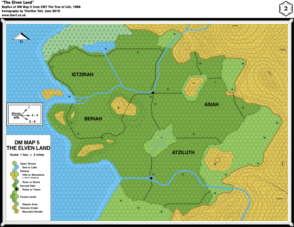
CM7 The Elven Land, 2 miles per hex
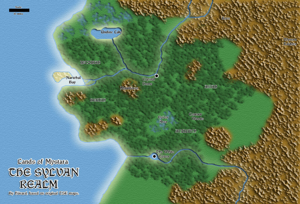
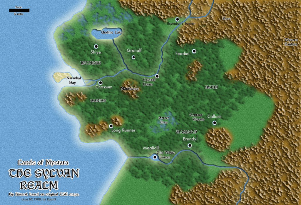
Bruce Heard’s second foray into Mystara, and his first focusing on a Known World nation, CM7 focused on the Selinar region of Alfheim. Following the development of the Emerlas region in O2 two years before, CM7 was the second module to zoom in on Alfheim, although in fact much of the module takes place in the Sylvan Realm on the other side of the continent.
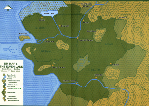
CM7’s maps are primarily notable for their use of contour lines — a first for Mystara’s geographical maps, and one that would not be repeated in many future maps.
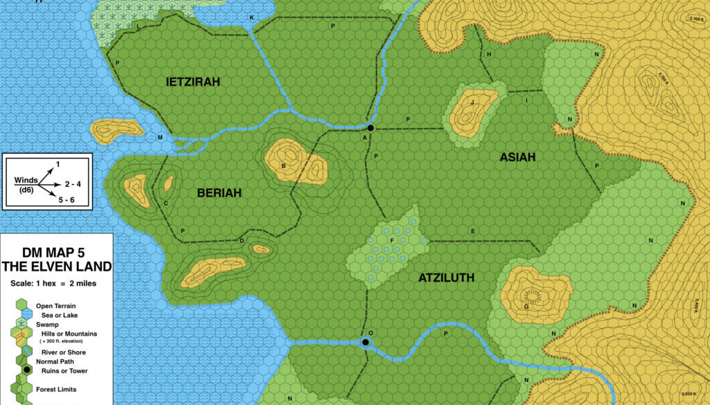
Replica Map (June 2019)
Sources
- CM7 The Tree of Life (1986) (PDF at DriveThruRPG)
- “DM Map 5 The Elven Land”, cover gatefold (Cartography by Tom Darden)
Chronological Analysis
This is Map 45. It was published in February 1986. The updated version of this map has not yet been released. See also Appendix C for annual chronological snapshots of the area. For the full context of this map in Mystara’s publication history, see Let’s Map Mystara 1986.
The following lists are from the Let’s Map Mystara project. Additions are new features, introduced in this map. Revisions are changes to previously-introduced features. Hex Art & Fonts track design elements. Finally, Textual Additions are potential features found in the related text. In most cases, the Atlas adopts these textual additions into updated and chronological maps.
The first entirely new area introduced in 1986 was the Elven Land in CM7 Tree of Life. Located thousands of miles away from the Known World area, this land is presented as an ancestral ground of the elves of Alfheim. The map itself is mostly devoid of labels, so most of the additions can be found in Textual Additions for CM7 below.
Additions
- Borders — Although none are marked, the edges of the forest can be taken to be the edge of the Elven Land.
- Coastline — The coast along an unnamed sea is all new here.
- Dominions — Asiah, Atziluth, Beriah, and Ietzirah appear to be either region or dominion names, although which is not clear from the map.
- Islands — An island at the estuary of the northern of the two river systems, as well as a river island (marked “O”) on the course of the southern river.
- Lakes — A lake bordering on the course of the swamp in the north.
- Mountains — In a first for Mystara’s maps, hills and mountains are illustrated with contour lines, in this case 300 ft. lines. The Elven Land appears to be surrounded by high ground, except in the southwest along the coast. A volcano crater is marked at the top of one of the mountains.
- Nations — The title suggests Elven Land to be a nation.
- Plateaus — None, but the “mountain border” is marked all along the edge of the higher ground using a plateau-like symbol — similar to how it appeared in B10.
- Rivers — Two river systems appear, in the north and the south, both unnamed. The northern system appears to bifurcate, with one strand heading northwest to the swamp, while the other continues west to a delta at the coast.
- Seas — The west is dominated by an unnamed sea.
- Settlements — Two are marked using a “Ruins or Tower” symbol.
- Terrain — Unsurprisingly the Elven Land is dominated by forest, including some hills covered with forest. There is also an interesting new element in the geyser area.
- Trails & Roads — A network of “normal paths” crisscross the forest.
Hex Art & Fonts
- Fonts — Helvetica.
- New Symbols — Contour Lines, Geyser Area (blue unfilled circle), Volcano Crater (a circle of dashed lines).

Textual Additions (CM7 1986)
- Dragons — Sulfar, a large red dragon that Moorkroft has sent to Selinar (pages 3-4, 6). It sits atop the hill with the Cave of the Dark Watcher. Presumably it usually resides in or near the Sylvan Realm.
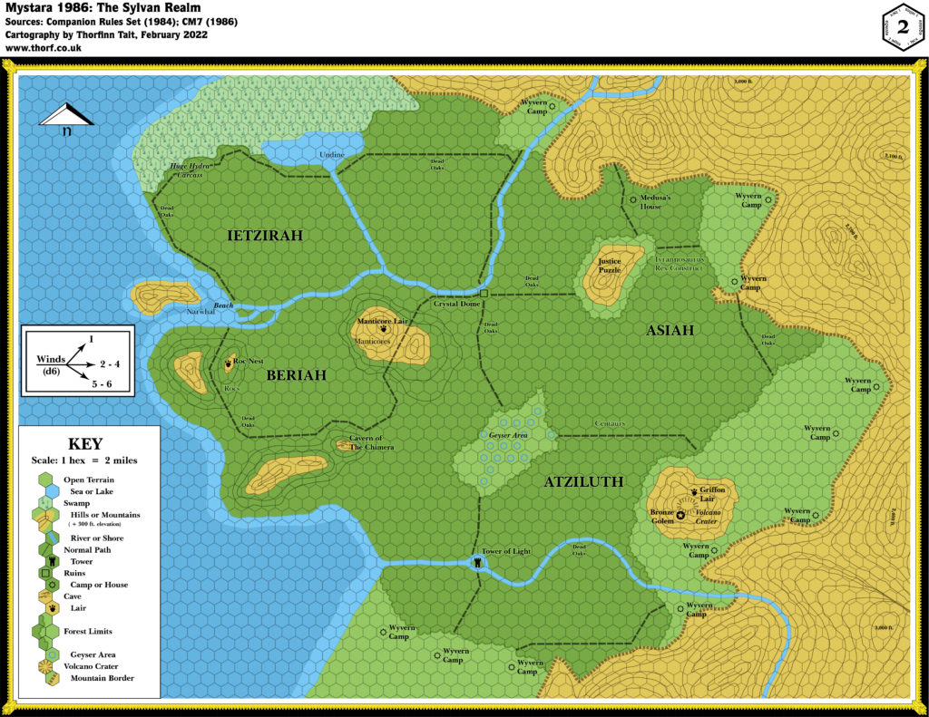
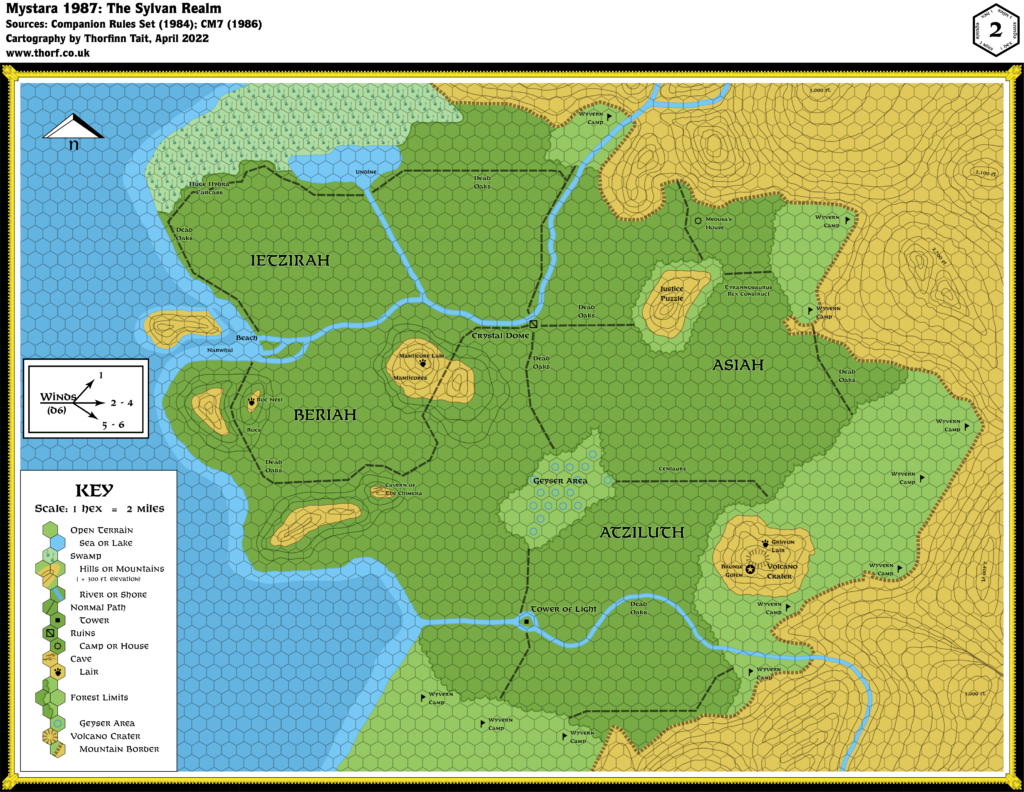
- Fauna — Random creatures likely to join the elven army, and therefore present in this region include treants, sprites, pixies, blink dogs, and unicorns. (Page 12) Other creatures are given in the keyed encounters, including manticores (location B, page 13), rocs (C, page 13), centaurs (E, page 15), griffons (F, page 15), a medusa (H, page 16), and various unique creatures and constructs (for which see the updated map).
- Forests — In the Sylvan Realm, hexes marked P denote the location of dead oaks.
- History — The story of the Sylvan Realm was detailed as follows: “Long before the oldest elf of the Feadiel tribe was born, the most ancient elven clan faced its doom. At the end of a long and bloody war, surrounded by their sylvan domain, the clan decided to hide their Tree of Life and magic-jar in mass, one elf into each great oak of the forest, hoping to outlive this dark century. Only one would remain as Keeper of the Sacred Tree, until the twilight of his life, at which time another elf would be wakened to replace the eldest.” Although the lifespan of an elf has not been explicitly fixed at this point, this presumably places the Sylvan Realm’s struggle far in the past. (The next paragraph gives a hint in that the Treekeeper only needs to wake a replacement in the time of the Mage’s great-grandson, i.e. Moorkroft IV.) The text continues: “When the black army swarmed the woods, no elf was there to be found “alive.” The Sylvan Realm was ransacked and, without knowing, many elves were destroyed.” After this, the land was occupied by the forces of Moorkroft. This continued for another three generations of Moorkrofts, so that the current Moorkroft IV is “the mage’s great-grand-son” (all page 2 up to this point) — actually his fourth incarnation. Moorkroft I, II, and III presumably had normal lifespans, so the last tree keeper returned at some point after the span of three human lifetimes. Moorkroft IV has been extending his life since then. (All page 25) One more point is worth noting here: “As for the Feadiels, refusing the passive solution of the clan, they took a small limb of the Tree of Life and fled. They established another tribe, in another land, and so became the ancestors of the party’s clan.” This clearly refers to the Feadiels of Alfheim. (Page 2)
- Lairs — The encounters in the Sylvan Realm detail a number of lairs:
- Manticore Lair — 4 manticores in a cave at the top of the hill. (Page 13)
- Roc Nest — a single large roc with 5 eggs. (Page 13)
- Griffon Lair — 16 griffons lairing on the north side of the volcano. (Page 15)
- Medusa’s House — More a little cottage than a lair, it houses a single medusa. (Page 16)
- Nations — CM7 introduced more details than ever before on the elves of Mystara:
- The Elven Land introduced in this module “may be somewhere else on the continent, the remotest area being best. If using the D&D Companion Set continental map, the area suggested is the northwest corner.” (Page 2) Thus, the Elven Land is to be placed in northwestern Brun. While the area covered by the Elven Land’s 2 mile per hex map is insignificant compared to the continental map of Brun, it seems reasonable to use it as a guide, placing the Elven Land on the northwest coast close to the latitude of Frosthaven on the other side of the continent. The name Elven Land is used on the map and in the text, but the text also uses Sylan Realm (page 2, etc.), and it is this latter name that has stuck ever since, from GAZ5 onwards. Pages 12-18 and 23-36 detail various parts of the land. It is said that “The land of the ancients is a remote realm, bordered on the north by a huge swamp-forest, on the east and southeast by a chain of high mountains, and on the west by an ocean. The south is open to vast steppes. Most of the realm is covered with forest”. (Page 12) “The forest was originally divided into four areas called Ietzirah, Beriah, Atziluth and Asiah, the four archaic terms for Water, Air, Fire, and Earth.” These names are taken from the Kabbalah’s Four Worlds, where they are indeed representative of those elements, except that Water and Air are inverted in the order listed. (Page 12, reference to Wikipedia)
- Settlements — In the Sylvan Realm, the remains of the original elven clanhold are located at the crossroads at location A, where “the surrounding area seems to be covered with endless ruins” overgrown with oaks and bushes. Only the Crystal Dome and its internal structure holding the Tree of Life survives. (Page 13) All of the locations marked N are “Wyvern Camps”, which are the camps of Moorkroft’s black hordes. There are eleven such camps, each of which is garrisoned with 100 orcs, 12 wyvern riders with their 12 mounts, 12 hellhounds, and a fire giant commander. (Page 18)
Analysis
The precise location of the Sylvan Realm is up in the air at this point; although its general location in Northwestern Brun is fixed, the coast doesn’t neatly fit into any one spot on the continental map. Wherever it goes, some adaptation will be necessary. One option would be to apply a rotation of some sort. For example, a 30º rotation to the right would make its coast line up with the continental map far more easily, while also changing its hex grid from horizontal to vertical columns. On the other hand, this would mess with directions referenced in the adventure, so perhaps it would be better to use it without a rotation.
In any case, since there is no way to conclusively work this out at this point, I will leave it vague for Mystara 1986.
Join in the Discussion at The Piazza
Come and join in the discussion about this map at The Piazza, where I am holding a “read through” of the Let’s Map Mystara project.



2 October 2020 @ 3:25 am
I was a bit puzzled by the placement of this map, so I picked up a copy of the module to see what it says about it. It is intentionally vague. CM7, page 2:
> The Elven Land may be anywhere else [than Alfheim] on the continent, the remotest area being the best. If using the D&D Companion Set continental map, the area suggested is the northwest corner.
2 October 2020 @ 8:42 am
The precise location can actually be determined from the shape of the coast, although the scale of the map means that really it could be placed anywhere.
I am tackling this in Let’s Map Mystara 1986, which will hopefully be published soon. At that point, I’ll add all of the textual additions — including the note that you found — to this article.
Thanks!
2 October 2020 @ 11:10 pm
Thank *you*!
I was very glad to see that you are still working on this, since the website hadn’t been updated for over a year. Looking forward to the next instalment of Lining Up Mystara in particular.
Keep up the great work!
2 October 2020 @ 11:48 pm
Thanks!
I’ve been working on these projects for more than fifteen years now. Spurts of activity come and go, but I always come back to it. That’s just life, I suppose. There were a few years among those fifteen that I barely did a single map, and others where there was a flurry of activity.
Lining Up Mystara has basically evolved into Let’s Map Mystara at this point, I think — though I’m reconsidering how I publish that project, too. Massive long articles don’t seem to be working very well. Either way, there are quite a few fun issues coming up soon.
17 April 2021 @ 1:46 am
Man, ya left us with a real teaser/cliffhanger in regard to placement! Looking forward to the full 1986 map.