Dragon 154 Jungle Coast
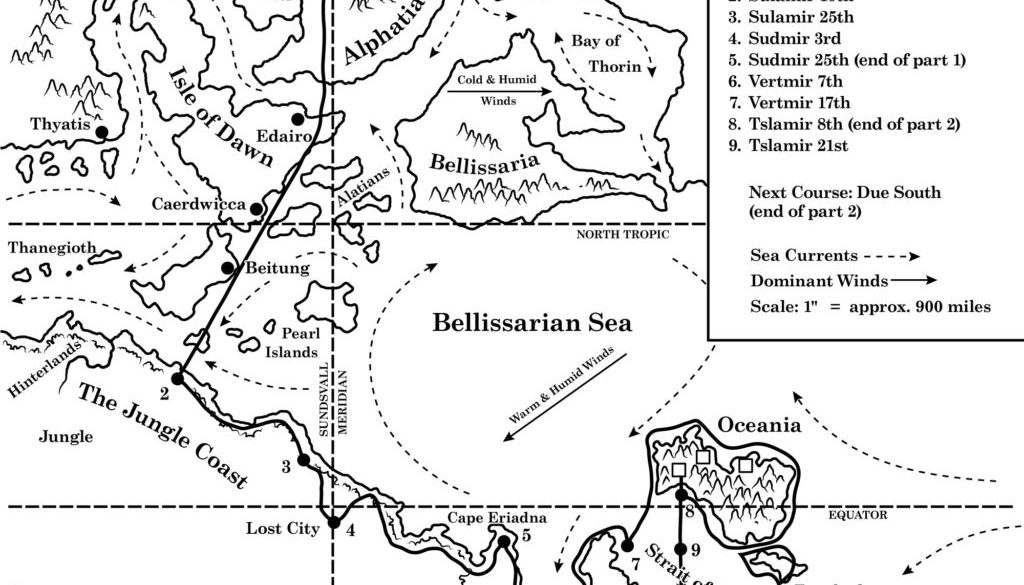
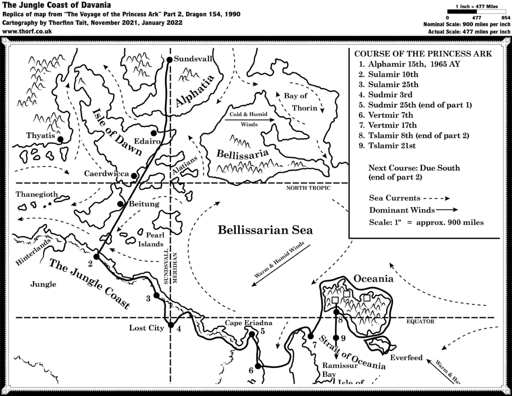
With the Princess Ark’s departure from Alphatia, this was the first of many maps plotting the ship’s course across the world. And even though the simple line art style didn’t provide for a great deal of detail, this map and its successors nevertheless supplied some nice new details, including a few named settlements and various other map labels.
Replica Map (January 2022)
Sources
- The Voyage of the Princess Ark Part 2: Into the mountains, to meet with … doom, Dragon 154 (February 1990)
Chronological Analysis
This is Map 132. It was published in February 1990. The updated version of this map has not yet been released. See also Appendix C for annual chronological snapshots of the area. For the full context of this map in Mystara’s publication history, see the upcoming Let’s Map Mystara 1990.
The following lists are from the Let’s Map Mystara project. Additions are new features, introduced in this map. Revisions are changes to previously-introduced features. Hex Art & Fonts track design elements. Finally, Textual Additions are potential features found in the related text. In most cases, the Atlas adopts these textual additions into updated and chronological maps.
Additions
- Course map — The map tracks the course of the Voyage of the Princess Ark.
- Dominant Winds — Bruce Heard started what would become a long-running trend for his maps, showing the prevailing winds on the map. The winds are split into two categories, cold & humid, and warm & humid.
- Latitudes — For the first time on a Mystaran map, both the equator and the northern tropic are marked.
- Longitudes — The Sundsvall Meridian is defined and shown for the first time here.
- Seas — Bellissarian Sea, obviously derived from the nearby island continent, appears here for the first time.
- Sea Currents — In another first for Mystara, the direction of the currents is shown.
- Settlements — Three unnamed ruins are shown on Oceania.
- Terrain — Jungle Coast adapts the Master Set (1985) label “The Coast (aka The Four Kingdoms)” to create a new name for the area. The Jungle itself is shown, extending from west of the Hinterlands almost to the eastern coast opposite Cestia. Other new named features are Cape Eriadna, Ramissur Bay, Strait of Oceania, and Everfeed.
Revisions
- Terrain — Oceania is even more mountainous at this larger scale than it appeared on the Master Set map.
Hex Art & Fonts
- Symbols — A simple, clean line art style. Wind direction (solid line with arrow at one end) and sea current (dashed line with arrow at one end) are new here.
- Fonts — Zapf Book (legend), Century Schoolbook (everything else).


Textual Additions (Dragon 154, 1990)
- Settlements — Haldemar describes Oceania’s ruins: “We discovered the abandoned ruins of two towns built on ledges above the sea. Their architecture is unknown, and time has washed away any inscriptions or paintings. Judging from several imposing buildings, this must once have been an advanced culture.” (Page 91b) The northernmost ruin is described as follows: “…another ruined town, this one quite huge and with a once-mighty citadel.” (Page 91bc) It is later referred to as a “ruined city” (page 92a).
- Terrain — The “northern end of the Isle of Cestia” is named Cape Andor by Haldemar (page 91a). Cape Eriadna was named by Haldemar in Dragon 153; Everfeed is named in this issue; and Ramissur Bay, though marked on the map in this issue, is named by Haldemar during the course of the next episode, in Dragon 155. Oceania’s terrain is described as follows: “A few forests grow along the rare beaches of Oceania, but for the most part its mountains form jagged cliffs that drop straight into the sea. The reefs and shoals around Oceania would be deadly to seafaring vessels. The mountains rise over 20,000’ in height. ” (Page 91b) Further: “…a narrow mountain pass that opens over a small bay on the south side of the island. Through the pass flows a river that forms a high cataract plunging straight into the bay.” (Page 91b)

