Dragon 155 Cestia and Oceania
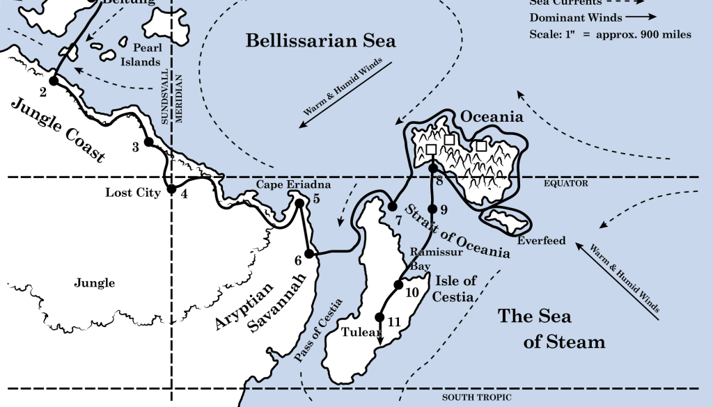
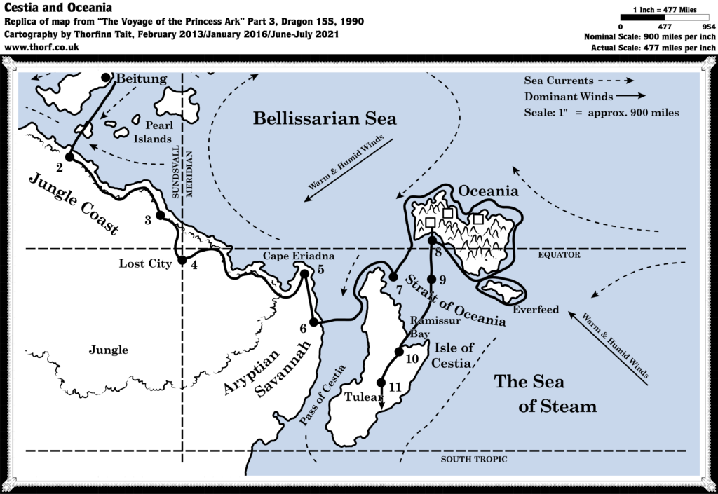
The second flight course map featured in Bruce Heard’s Voyage of the Princess Ark series, in Dragon Magazine. This map is significant because it is the first to show the position of the equator, in addition to providing some geographic and political names for the region. The simple line art maps were eventually replaced with full colour hex maps when the Princess Ark reached Sind and moved on to the Savage Coast.
Replica Map (July 2021)
Legend
The article provided a legend for the map as follows:
COURSE OF THE PRINCESS ARK
1. Alphamir 15th, 1965 AY
2. Sulamir 10th
3. Sulamir 25th
4. Sudmir 3rd
5. Sudmir 25th (end of part 1)
6. Vertmir 7th
7. Vertmir 17th
8. Tslamir 8th (end of part 2)
9. Tslamir 21st
10. Tslamir 24th
11. Andrumir 7th (end of part 3)Next Course: Due South-West (end of part 3)
Sources
- The Voyage of the Princess Ark Part 3: To seek out new life and new civilisations, Dragon 155 (March 1990)
- Page 53
Chronological Analysis
This is Map 133. It was published in March 1990. The updated version of this map has not yet been released. See also Appendix C for annual chronological snapshots of the area. For the full context of this map in Mystara’s publication history, see Let’s Map Mystara 1990.
The following lists are from the Let’s Map Mystara project. Additions are new features, introduced in this map. Revisions are changes to previously-introduced features. Hex Art & Fonts track design elements. Finally, Textual Additions are potential features found in the related text. In most cases, the Atlas adopts these textual additions into updated and chronological maps.
Additions
- Latitudes — This is the first labelled appearance of the southern tropic. It doesn’t yet have a name, labelled here simply as south tropic.
- Seas — The Sea of Steam and the Pass of Cestia are both new here.
- Settlements — Tulear, capital of one of the nations on the Isle of Cestia.
- Terrain — Though its label had been partially visible on Dragon 154’s map, Aryptian Savannah appears here in full for the first time.
Revisions
None.
Hex Art & Fonts
- Symbols — A simple, clean line art style.
- Fonts — Century Schoolbook throughout.

Textual Additions (Dragon 155, 1990)
- Nations — There are four kingdoms on the Isle of Cestia: Manakara is the largest, in the central region. Androkia is in the south, populated by “the descendants of the island’s original natives, who were pushed back when the ancient Oceanians fled” (page 54b). Morovoay and Ambiroa lie to the north of Manakara, with Morovoay “on the western shore” and Ambiroa “on the eastern shore” (page 54b).
- Settlements — Tulear is “a large urban centre with high walls” (page 54a).
- Terrain — The eastern coast of Cestia features “heavy forest and hills” (page 52a). Moving south, “After the rugged, hilly terrain and heavy forest of Ramissur Bay came a series of plateaus on which the Cestians grow their crops. The plateaus are well irrigated, with many small canals and dams. Farming communities cluster at the crossroads.” (Page 54a) It is noted that most of the population of the four kingdoms on Cestia “remains hidden in the mountains or in the forests” (Page 54b).

