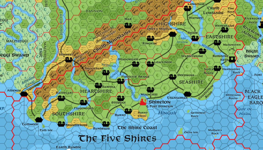
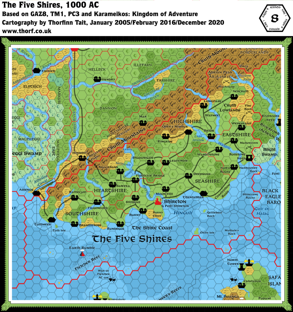
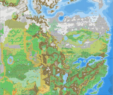
Five Shires, 8 miles per hex
The Five Shires are green and pleasant with rolling fields, dark woods, and little wasteland. This is due in part to the position of the Shires between mountains and sea. Moist air blowing inland cools and must leave its moisture behind as it rises over the peaks, making the Shires often wet and misty.
from GAZ8 The Five Shires, by Ed Greenwood
Map (December 2020)
Sources
- GAZ4 The Kingdom of Ierendi (1987) (PDF at DriveThruRPG)
- GAZ8 The Five Shires (1988) (PDF at DriveThruRPG)
- TM1 The Western Countries (1989)
- PC3 The Sea People (1990) (PDF at DriveThruRPG)
- Rules Cyclopedia (1991) (PDF at DriveThruRPG)
- Karameikos: Kingdom of Adventure (1994) (PDF at DriveThruRPG)
Comments
This map was already very dense in its first instance in GAZ8. Most of the updates are to bring the map in line with the text, as the two had a number of inconsistencies.
Notes
- Adrian Peak — this named peak was added for TM1.
- Aercruth — a village in the Cruth Lowlands. The GAZ8 DM’s Booklet has “Aercruth” no less than seven times (pages 37-39). However, the poster map labels the village “Aergruth”. TM1 keeps the map spelling, as does the Rules Cyclopedia map. The updated map goes with the text spelling.
- Burny Cliffs — “The promontory between Burny and the Hingulf rises into high, windswept hills that drop to the sea in sheer rock cliffs of up to five hundred feet in height.” (GAZ8 DM’s Booklet, page 42. The name comes from the same page.) These have been added to the updated map.
- Coastal Waters — many Gazetteers didn’t show shallow and deep water, including GAZ8. TM1 showed coastal waters for the first time for the Five Shires.
- Darkwood — the GAZ8 DM’s Booklet (page 37) refers to this wood in Highshire, into the depths of which no hin normally goes “for any reason”. It’s hard to see which stretch of woods this refers to, although page 39 rules out the “nameless woods” east of Waymeet. This feature could be marked on a larger scale map, but there isn’t space at this scale to mark it on.
- Deepmoss Road — the road from Deepmoss to Thantabbar is named the Deepmoss Road; GAZ8’s DM’s Booklet refers to it by this name (capitalised) on page 42. However, see also Deeps Road.
- Deeps Road — GAZ8 says that this road runs “from Thantabbar into the interior of the Shires” through Deepmoss and Leafkindle (DM’s Booklet page 43). Confusingly, Deepmoss supposedly lies at the crossroads of the Coastfollow Road and this road, but since the Coastfollow Road also goes through Thantabbar, this would make them in fact the same road. More likely the Deeps Road (which is also referred to as the Deepmoss Road, page 42) runs from the junction northwest of Thantabbar. Also, which way the road turns after Leafkindle is not at all clear.
- Forested Hills — the easternmost hex, bordering on Karameikos, was changed to forested hills in Karameikos: Kingdom of Adventure. This change seems in line with the Karameikos forested hills change, so the Atlas has adopted it.
- Islands — the labels for the small islands of the Shire Coast, present on GAZ8’s map, were missing from TM1.
- Lake Hindim — this small lake, formed by a widening of the Wardle River, is referred to as “Lake Hindim” on page 37 of GAZ8’s DM’s Booklet, but “Lake Hiadim” on the poster map. “Hiadim” seems likely to be a typo, although it appears again on TM1 and the Rules Cyclopedia map. The updated map considers “Hindim” to be the correct form.
- Mistmyr Falls — GAZ8 has “Mistmyr” twice in the text (DM’s Booklet, pages 9 and 55). Page 9: “the awesome Mistmyr Falls (a fall so long and violent that spray always enshrouds the foot of the plunge in roiling mists)”. However, the poster map has “Miskmyr”. TM1 uses the spelling “Myskmyr”, and this change was carried through onto the Rules Cyclopedia map. The updated map goes with “Mistmyr”.
- Moon Hill Road — described on pages 44-45 of GAZ8’s DM’s Booklet, this road doesn’t seem to be marked on the map at all. It apparently runs from somewhere between Fishtickle Bridge and Leafkindle down through Moon Hill, southeast to join up with the Coastfollow Road. The updated map includes it as a short road following the Ithypool River.
- Rollstone Keep — Rollstone Keep is the only military settlement marked on the map. GAZ8 pages 39c-40c describe it as a “stout-walled stone fortress” with a population of 2,900 and all the usual features of a small town. On the other hand, “Over half of the population of Rollstone Keep consists of the standing army of the Eastshire Fangs… Most of the other hin in town are the Journeyfoot clan who lived here before the village was fortified…” Given the fact that this is clearly a town, and despite the name, the Tower/Keep symbol seems rather unsuitable, and has been replaced by a Fort symbol since this is now effectively a military town.
- Shadowgate — GAZ8’s DM’s Booklet (pages 46-47) refers to this village as “Shadowgate” nine times. Not once is the “Shadowgates” of the poster map used, despite it appearing on the black and white reproduction of the map on the same page. The updated map goes with the text’s “Shadowgate”.
- Waymeet — the label for this crossroads on GAZ8’s poster map was missing from TM1.
References
- The Five Shires at the Vaults of Pandius
- The Five Shires map thread at The Piazza
- Mapping Issues: Towers, Keeps, Forts and Castles at The Piazza
- Mapping Issues: How to Mark Capitals at The Piazza
Thanks to:
Michele Carpita (LoZompatore), JoeNotCharles, Simone Neri (Zendrolion), Andrew Theisen (Cthulhudrew)

5 February 2016 @ 6:20 pm
Where did the Darokin dominion names come from?
There is one in this map called Illefarn. That is a fairly well-known name from the Forgotten Realms.
5 February 2016 @ 9:05 pm
I’d love to give you the link to the discussion, but unfortunately it was on the old Wizards boards. 🙁 And it was so long ago that I don’t even remember precisely what happened.
But I believe that the names stemmed from that discussion, with various people proposing names as well as placing the few known official names on the map. The borders for the provinces (mostly?) come from official maps, but there were no names given in GAZ11.
Perhaps someone who participated in the discussion can tell you more…? I’m surprised to hear there’s a Forgotten Realms name in there. Other than what I learned from the Eye of the Beholder series, I’m pretty clueless about the Realms.
9 December 2020 @ 2:55 pm
A few years later I have found the answer! .. those Gleemax boards are on Pandius now and I have come across it today. So Illefarn was based on the Darokin ships name from the counters GAZ4 Ierendi, A rare occurrence of TSR replicating names. It is amusing as the counter is actually only a few pieces over from an Ostland ship called Thorfinn.
20 December 2020 @ 7:38 pm
Hehe. I remember noticing that when I first bought GAZ4. It’s always nice to find my name somewhere — a pretty rare occurrence for me! 😉
Thanks for the info on Darokin Provinces. I really must restore that thread and add it to the Archives here. I’d also like to add detailed notes to the Darokin article about the origins of the province names, if that proves possible.