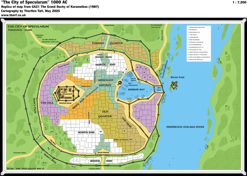
GAZ1 Specularum
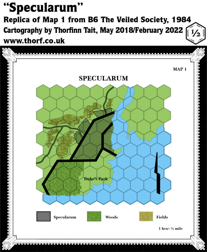
GAZ1 The Grand Duchy of Karameikos was revolutionary for Mystara in all sorts of ways. One of the more unexpected things it gave us was a completely new map of the capital city of Specularum. This had been mapped three years previously in B6 The Veiled Society, but GAZ1’s map bore almost no resemblance to B6’s.
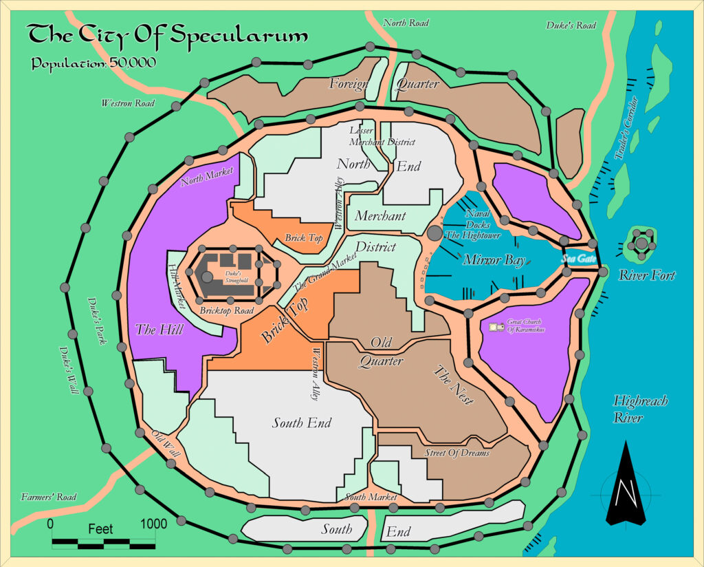
But while GAZ1’s map was radically different in shape and style, it also included a wealth of detail that was brand new to the setting. It could be said that it adapted the main points of B6’s map — primarily the Duke’s Stronghold, the Duke’s Park, and the city’s location on the West Bank of a river — but the lack of resemblance could suggest that B6’s map was either unknown to the cartographers, or disregarded for some reason. We will probably never know, but perhaps the most likely scenario is just that the designers wanted to go with a different style. After all, the style of this map was doubly important, because it set a strong precedent for all successive Gazetteer town maps.
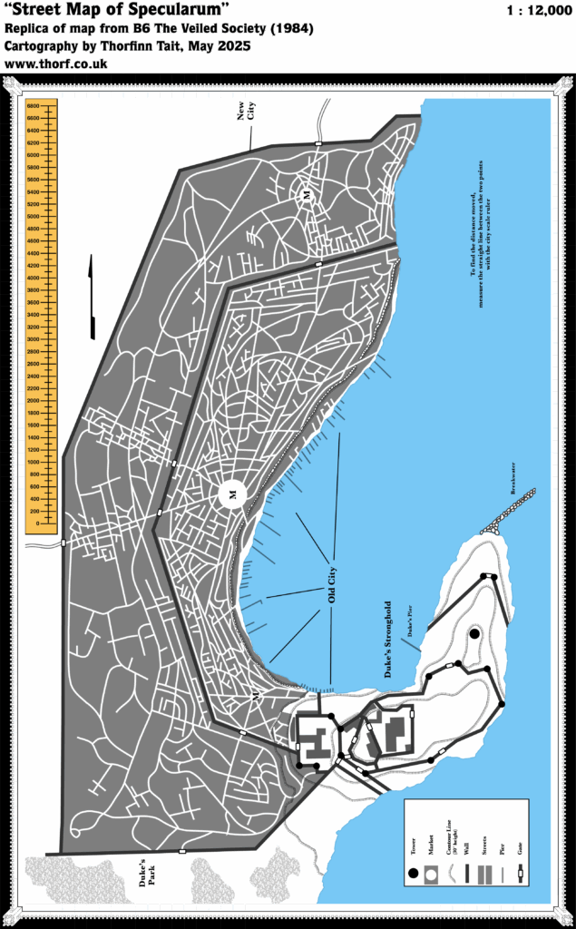
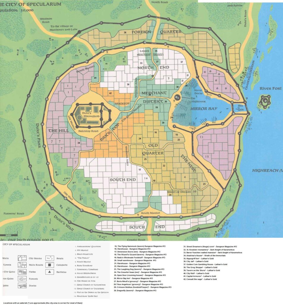
In terms of detail, the city was split up into named quarters, with a few streets named, and fourteen keyed locations — although number 12 was accidentally left off the map. All of this was new in GAZ1.
This map would be reprised, mostly unchanged, in a number of later products, including B1-9 and Karameikos: Kingdom of Adventure.
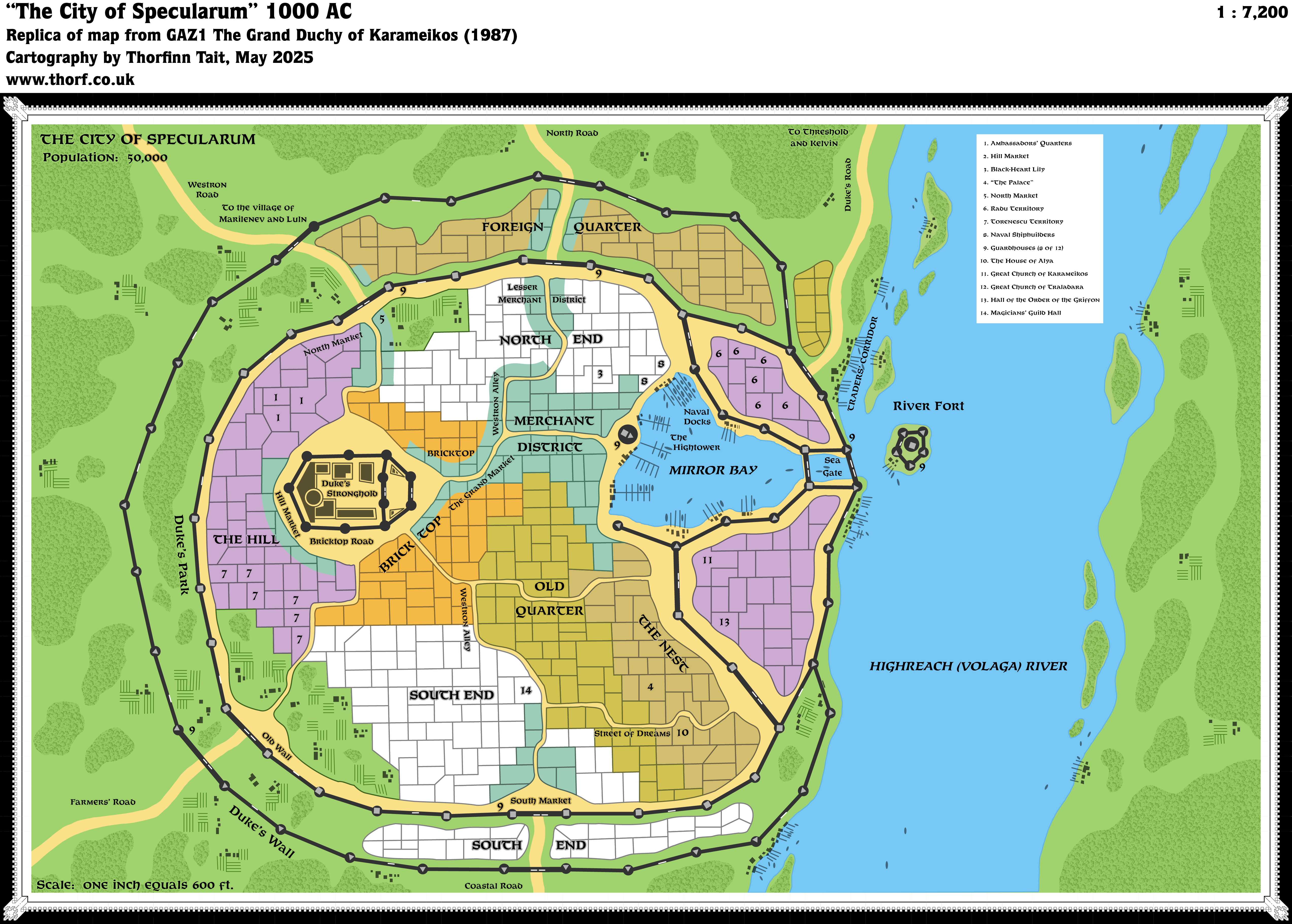
Replica Map (May 2025)
Sources
- GAZ1 The Grand Duchy of Karameikos (1987) (PDF at DriveThruRPG)
- Poster map, Cartography by Dennis Kauth, David C Sutherland III, Ron Kauth
References
- New Map: GAZ1 Specularum post at Patreon
Chronological Analysis
This is a Town Map. It was published in May 1987. The updated version of this map has not yet been released. See also Appendix C for annual chronological snapshots of the area. For the full context of this map in Mystara’s publication history, see Let’s Map Mystara 1987.
The following lists are from the Let’s Map Mystara project. Additions are new features, introduced in this map. Revisions are changes to previously-introduced features. Hex Art & Fonts track design elements. Finally, Textual Additions are potential features found in the related text. In most cases, the Atlas adopts these textual additions into updated and chronological maps.
Additions
- Almost Everything — Other than the Revisions noted below, everything on this map was new. It formed the base line for all future maps of Specularum. As the Atlas doesn’t focus on town maps at the present time, I will only note here things that may affect the hex maps.
- Roads — The Westron Road and the Duke’s Road are present as expected, but there are three other roads marked: Coastal Road, Farmers’ Road, and North Road. There is minimal coast to the south, but the hex map also marked this road leading due south to the coast at the mouth of the Volaga. The Farmers’ Road presumably leads to the farmlands around Specularum, which the Marilenevs are said to control. (Although it looks as if it could lead to Marilenev Village, the Westron Road is explicitly labelled to lead there.) Finally, the North Road is more puzzling, as there doesn’t seem anywhere for it to lead; nothing is marked north of the city on any of the hex maps. It seems likely that it’s the beginnings of a new road, or perhaps just a minor road. It also seems likely that it may link up with either or both of the other main roads if for no other purpose than to provide access to that entrance to the city.
Revisions
- Locations — A couple of locations from the old B6 map were adapted to the new layout: the Duke’s Stronghold retained the same name, but was moved from a promontory east of the city to (likely) a promontory in the middle of the city; and the Duke’s Park remained a region of enclosed forest and greenery outside the walls, but in GAZ1 it was enclosed completely within the inner and outer walls, while B6 had it enclosed by walls on two sides and the coast on the others.
Hex Art & Fonts
- Art — Gazetteer town map style, with subdued but clear colours and a palette similar to the hex maps. The art itself was mainly simple line art, with the occasional use of familiar patterns such as for the forests.
- Fonts — Feinen Bold throughout.
Textual Additions (GAZ1, 1987)
- Location — Specularum was built “just west of the point where the Highreach river enters the sea” (GAZ1 page 5b), suggesting that the coast to the south is reasonably close by, off the edge of the map.
- Name — GAZ1 details the meaning of the city’s name, as well as noting that it was originally named Marilenev: “The military commander at the time renamed Marilenev “Specularum” (The Mirror City) after the reflective beauty of Marilenev’s bay.” (GAZ1 page 4a) The timing for the name change was the Thyatian invasion in 900 AC (GAZ1 page 15c).