
Hollow World Set Outer World Arctic Cap
The Hollow World Campaign Set pioneered the intriguing (not to mention highly eccentric) idea that the world of Mystara was hollow. The world maps appeared to tackle this peculiar configuration by adopting a projection with flat northern and southern edges. However, in fact these were simply Robinson projections, and the flat lines at the top and bottom of the maps would normally represent the poles of a regular globe.
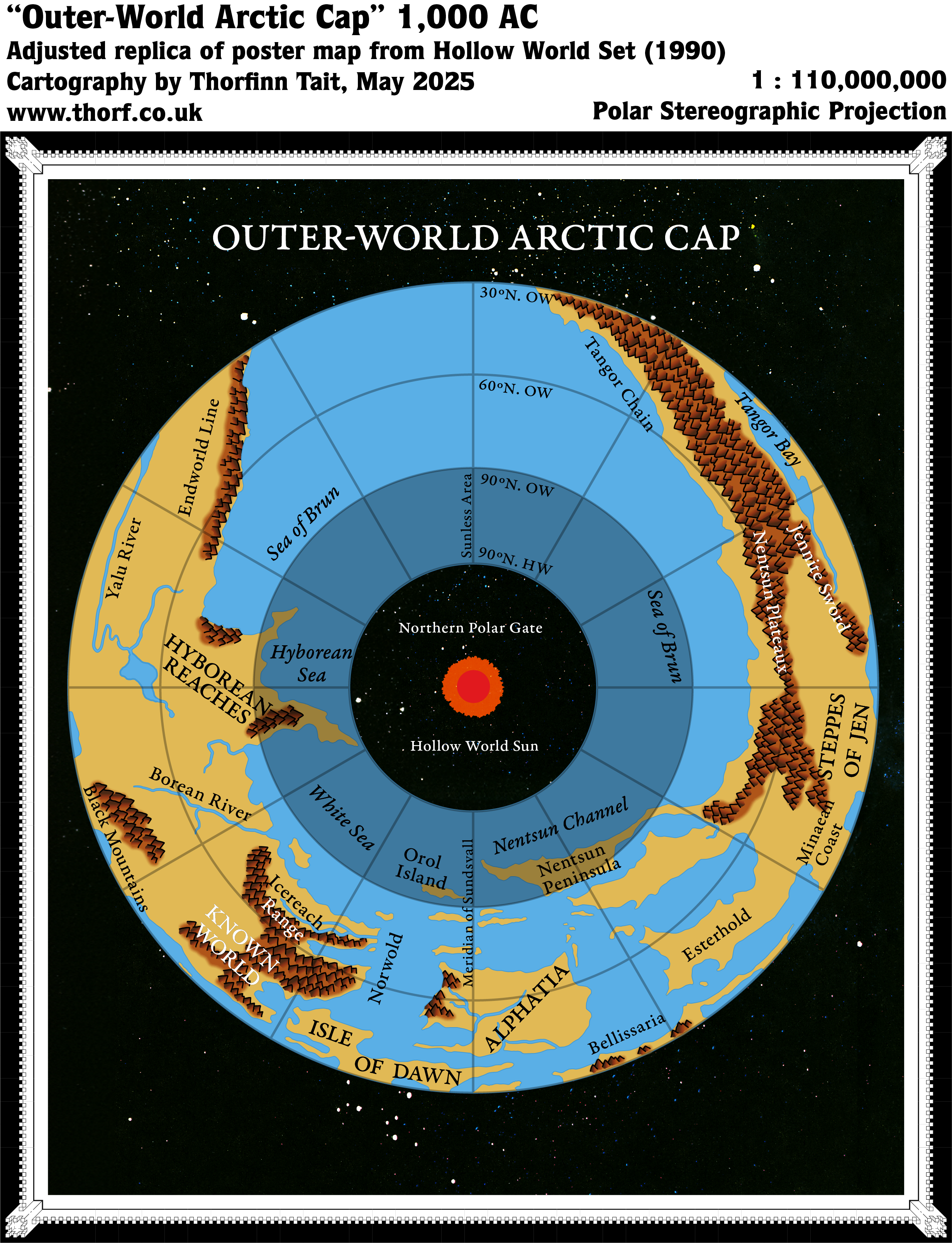
Nevertheless, the set’s cartographers came up with a far better way to show the strange polar openings of the extreme north and south. They did this through a series of four maps: two for each pole, outside and in. These maps used a Polar Stereographic projection, and unlike the larger world maps, they made a far more spirited attempt at depicting the curved polar openings shown in the Hollow World Diagram.
This was the map for the Outer World side of the Northern Polar Opening. It had a number of interesting features, not least of which was its notation of latitude, placing the 90ºN latitude line (usually the North Pole) at the beginning of the polar opening’s curve. The lands folding into the opening were also clearly shown, with the northern tips of Hyborea as well as the Nentsun Peninsula and Orol Island (named here for the first time) clearly falling inside the region marked “Sunless Area”.
It was an admirable attempt at a map that I still find it hard to get my head around even today. There is simply no easy way to map the toroidal shape of the polar opening, as reference to real world tools and map projections is non-existent for such a configuration. All respect to TSR’s star team of fantasy cartographers, including David Sutherland, David LaForce, and Dennis Kauth.
Replica Map (May 2025)
Sources
- Hollow World Campaign Set (1990) (PDF at DriveThruRPG)
- Poster map 3 (Cartography by David C Sutherland, David S LaForce, Dennis Kauth, Frey Graphics)
References
- New Map: Outer World Arctic Cap post at Patreon
Chronological Analysis
This is Map 149. It was published in August 1990. The updated version of this map has not yet been released. See also Appendix C for annual chronological snapshots of the area. For the full context of this map in Mystara’s publication history, see Let’s Map Mystara 1990.
The following lists are from the Let’s Map Mystara project. Additions are new features, introduced in this map. Revisions are changes to previously-introduced features. Hex Art & Fonts track design elements. Finally, Textual Additions are potential features found in the related text. In most cases, the Atlas adopts these textual additions into updated and chronological maps.
Under Construction! Please check back again soon for updates.
Additions
- XXX —
Revisions
- XXX —
Hex Art & Fonts
- Hex Art —
- Fonts —
Textual Additions (Hollow World Set, August 1990)
- XXX —
")
")
")