
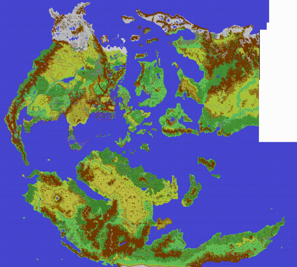
Kal’s Mystara East, 24 miles per hex
This map shows Mystara’s eastern hemisphere, joining up directly with his Mystara West map to create the first ever full map of the world at 24 miles per hex. The post for the western hemisphere contains a full explanation of the story behind these maps, as well as a summary of the timing of this map’s creation and posting. To cut a long story short, I’ve marked it as November 2006, but it may have been released as early as January 2005, or at some point in between.
The main innovation of Andrea’s world map, and indeed the feature that makes it the first ever completed world map at this scale, is Skothar. Thibault came close with his Mystara, 24 miles per hex map of 2002, but the one area that he never completed was Skothar. Andrea was the first to achieve this, with this map.
In order to complete this map, Andrea adapted most of Thibault’s Skothar, then finished it by adding in his own design for the Tangor Peninsula and the far eastern regions. Thus, most of the area east of Tangor Bay here is Andrea’s invention — and I believe it was the first time for this region to be hex mapped at any scale.
For these world maps, Andrea released only the versions with no labels, noting that these should be more useful to the community.
Fan-made Map by Andrea Francolini (c. November 2006)

This is an original map created by one of Mystara’s excellent fan cartographers. For more information on the cartographer, including a gallery of all their maps, see also Appendix M: Mappers of Mystara.
Sources
- Surprisingly few…
Fan Sources
- Christian’s Skothar, 72 miles per hex (1999)
- Thibault’s Skothar, 72 miles per hex (1999)
- Thibault’s Skothar, 72 miles per hex (2000)
- Thibault’s Mystara, 24 miles per hex (2002)
- Kal’s Brun, 24 miles per hex v1 (2005)
References
- All of Andrea’s maps at the Atlas of Mystara
- Andrea’s entry in Appendix M: Mappers of Mystara (upcoming)
- Andrea’s author page at the Vaults of Pandius
Chronological Analysis
This is a fan-made map. It was published in around November 2006. The updated Atlas version of this map is not yet available. See also Appendix C for annual chronological snapshots of the area. For the full context of this map in Mystara’s publication history, see the upcoming Let’s Map Mystara 2006. (Please note that it may be some time before the project reaches this point.)
The following lists are from the Let’s Map Mystara project. Additions are new features, introduced in this map. Revisions are changes to previously-introduced features. Hex Art & Fonts track design elements. Finally, Textual Additions are potential features found in the related text. In most cases, the Atlas adopts these textual additions into updated and chronological maps.
Under Construction! Please check back again soon for updates.
")
")
")