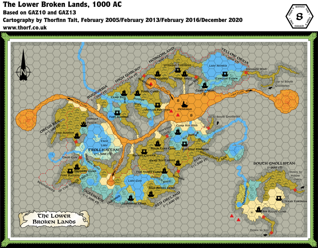
Lower Broken Lands, 8 miles per hex
The ten tribes of the Broken Lands occupy a vast underground network. These caves are huge, the largest stretching over 100 miles. A forest of colossal stalagmites supports the vaults, arching up to 300 feet high. The bottom of these caves is very uneven, deserving its name: the True Broken Lands. Their depths range from 800 to 1,600 feet below the surface. Huge, fortified gates often block passageways from one cavern complex to another. The largest can reach several miles wide. Rivers bubble up to the caverns, or seep in from large rivers on the surface, creating underground lakes.
The most breathtaking feature is the Lava Flow, a huge lake of molten rock that emerges from the bowels of the Known World. Magma flows into vast tunnels, and sinks back into whirlpools. […] Three underground rivers fall into the Lava Flow, producing a fearsome roaring noise and a thick fog that fills the cavern. […] Beyond the fog, at the centre of the Lava Flow, lies Oenkmar, Jewel of the Depths, an ancient city rumoured to be the Immortals’ Throne and the land of fallen warriors.
from GAZ10 The Orcs of Thar, by Bruce Heard
Map (December 2020)

Sources
- GAZ10 The Orcs of Thar (1989) (PDF at DriveThruRPG)
- GAZ13 The Shadow Elves (1990) (PDF at DriveThruRPG)
- Poor Wizard’s Almanac III (1994)
Comments
The Lower Broken Lands map was Mystara’s first fully detailed underground hex map. It was followed soon after by GAZ13’s map, which inexplicably changed the palette quite drastically. The Atlas uses a standardised hybrid of GAZ13’s and GAZ10’s palettes.
The altitudes marked on the map are quite interesting. It would be fascinating to have an isometric version of this map, showing the different layers of cavern, with the Shadowlands below and the surface lands above.
Notes
- Compass error — the direction indicated as north on the Poor Wizard’s Almanac III Lower Broken Lands map is actually east. This error was most likely introduced in the process of changing the map from landscape to portrait orientation.
- Fonts — for reference, the poster map uses the following fonts: Title 11-11.2 pt Feinen Bold; Dominion names: 9.6 Feinen Bold; Lakes and Rivers: 8 pt Feinen Italic; Settlements and Terrain Features: 7.8-8 Feinen Bold; “Boundaries of the World Above” caption: 7.8 Feinen Regular; Legend and Lava Flows: 6.3 Feinen Regular. Dominion names, “Boundaries of the World Above”, and Lava Flows in all capitals; all other labels in title case. Lake Morkia mistakenly marked as a terrain feature rather than a lake.
- Morkia River — the river flowing from Lake Morkia to the Lava Flow is named in GAZ10 (Player’s Guide page 13).
- Oenkmar — the updated map shows Oenkmar floating in the Lava Flow. It moves around, so the position is not exact.
- Palette — a hybrid palette for underground maps, using mostly GAZ13’s colours, with some of GAZ10’s added, has been used on the updated map. This is Atlas standard for underground mapping.
- Sandy Cave — one of the hexes adjoining the lava river was marked as volcanic sand on GAZ10’s map, but with the cave hex colour. Judging by the way the other hexes bordering on the river are all sand, this is most probably just an error. The updated map goes with sand.
References
- Broken Lands at the Vaults of Pandius
- Broken Lands map thread at The Piazza
- Mapping Issues: Underground Palette thread at The Piazza


20 December 2016 @ 3:15 pm
I would love to see you map the surface world based on the post destruction of nucleus of the spheres subsidence of the shadowelf and lower broken lands. Especially considering the night dragon synn has discovered the radiance. Thats a lot of hole.