
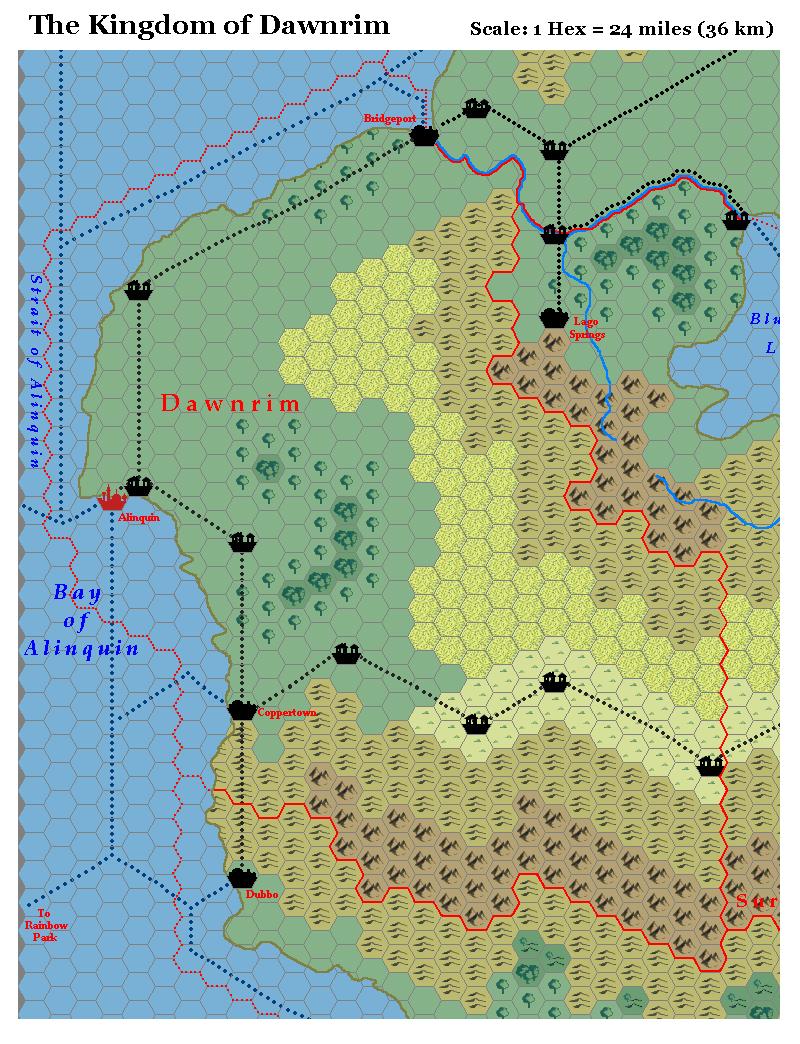
LoZompatore’s Dawnrim, 24 miles per hex
Michele’s Kingdom of Dawnrim includes one of his greatest changes to the island continent of Bellissaria’s maps: the addition of the arid lands originally detailed in the text of Dawn of the Emperors. He explained on the MMB at the time:
I turned vast stretches of plains into poor grazing lands, to take in account for PWAI info about (not very lucky) sheep and goat farming activities. In particular, I converted the plains just north of the (canonical) steppes, in order to explain why the road connecting Dawnrim and Lagrius was built on the steppes instead of the plains (if the plains are mostly arid, the steppes become a preferential choice for road and village-building).
The reasoning for this addition was sound, as was his addition of villages at appropriate spots. If anything, perhaps he could have added more villages — as Simone Neri pointed out in the MMB thread. Later maps, such as the Ramelin Mystara version of Bellissaria, would do just that, including and/or adapting Michele’s villages while adding more.
Fan-made Map by Michele Carpita (July 2006)
This is an original map created by one of Mystara’s excellent fan cartographers. For more information on the cartographer, including a gallery of all their maps, see also Appendix M: Mappers of Mystara.
Sources
- Dawn of the Emperors (1989) (PDF at DriveThruRPG)
- Wrath of the Immortals (1992) (PDF at DriveThruRPG)
- Poor Wizard’s Almanac (1992)
- Poor Wizard’s Almanac III (1994)
Fan Sources
- Thoughts about Bellissarian maps discussion thread at the MMB, archived at the Vaults of Pandius (July 2006)
- Thoughts about Bellissarian maps by Michele Carpita at the Vaults of Pandius (July 2006)
References
- All of Michele’s maps at the Atlas of Mystara
- Michele’s entry in Appendix M: Mappers of Mystara (upcoming)
- Michele’s author page at the Vaults of Pandius
Chronological Analysis
This is a fan-made map. It was published in July 2006. The updated Atlas version of this map is not yet available. See also Appendix C for annual chronological snapshots of the area. For the full context of this map in Mystara’s publication history, see the upcoming Let’s Map Mystara 2006.
The following lists are from the Let’s Map Mystara project. Additions are new features, introduced in this map. Revisions are changes to previously-introduced features. Hex Art & Fonts track design elements. Finally, Textual Additions are potential features found in the related text. In most cases, the Atlas adopts these textual additions into updated and chronological maps.
Under Construction! Please check back again soon for updates.
Additions
- Settlements — In Dawnrim, Michele added 7 new unnamed villages at appropriate locations.
- Terrain — The arid lands marked as poor grazing lands are new on this map, although previously mentioned in the text of Dawn of the Emperors.
Revisions
- XXX —
Hex Art & Fonts
- Hex Art —
- Fonts —
")
")
")