
LoZompatore’s Horken, 24 miles per hex
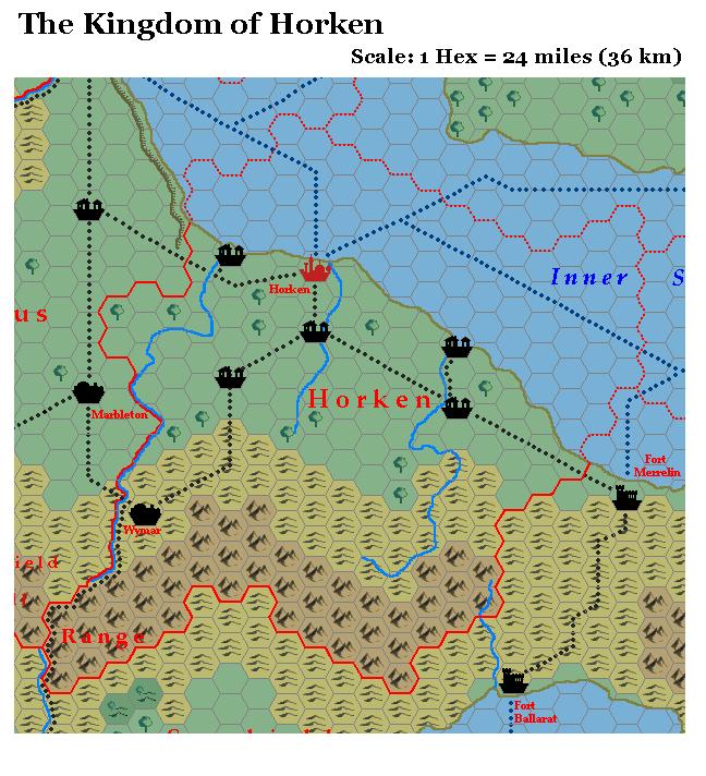
This is Michele’s map of the Kingdom of Horken, in south central Bellissaria on the Inner Sea of Horken. He explained his additions in his MMB post as follows:
This kingdom is crossed by a large network of roads, so it has a large number of villages. I added a couple more villages at the mouths of the rivers E and W of the capital, due to the fact that PWAI says that there are many deep water harbours and naval wharfs along the coast.
The same PWAI says that the plains of Horken are a mix of grasslands and woods, so I added some sparse hexes of forest along the rivers. Their number is quite small and it doesn’t modify the hex terrain type in the [smaller] scale (72 miles/hex) maps.
I added a road leading south from Wymar to South Harbour in the kingdom of Surshield. The road seems logical, due to the fact that Horken is a trading kingdom (PWAI) and that the Surkarian Range between the two cities is particularly narrow.
Fan-made Map by Michele Carpita (July 2006)
This is an original map created by one of Mystara’s excellent fan cartographers. For more information on the cartographer, including a gallery of all their maps, see also Appendix M: Mappers of Mystara.
Sources
- Dawn of the Emperors (1989) (PDF at DriveThruRPG)
- Wrath of the Immortals (1992) (PDF at DriveThruRPG)
- Poor Wizard’s Almanac (1992)
- Poor Wizard’s Almanac III (1994)
Fan Sources
- Thoughts about Bellissarian maps discussion thread at the MMB, archived at the Vaults of Pandius (July 2006)
- Thoughts about Bellissarian maps by Michele Carpita at the Vaults of Pandius (July 2006)
References
- All of Michele’s maps at the Atlas of Mystara
- Michele’s entry in Appendix M: Mappers of Mystara (upcoming)
- Michele’s author page at the Vaults of Pandius
Chronological Analysis
This is a fan-made map. It was published in July 2006. The updated Atlas version of this map is not yet available. See also Appendix C for annual chronological snapshots of the area. For the full context of this map in Mystara’s publication history, see the upcoming Let’s Map Mystara 2006.
The following lists are from the Let’s Map Mystara project. Additions are new features, introduced in this map. Revisions are changes to previously-introduced features. Hex Art & Fonts track design elements. Finally, Textual Additions are potential features found in the related text. In most cases, the Atlas adopts these textual additions into updated and chronological maps.
Under Construction! Please check back again soon for updates.
Additions
- XXX —
Revisions
- XXX —
Hex Art & Fonts
- Hex Art —
- Fonts —
")
")
")