
LoZompatore’s Mystara Modifications
This was the first map Michele posted to the MMB by himself, in October 2005. He had previously shared it on the Italian MMB. After that, Marco Dalmonte shared a set of Michele’s maps to the English MMB, including his Precataclysmic Mystara and 4000 BC maps, before Michele himself joined and posted his own comments – and then this map.
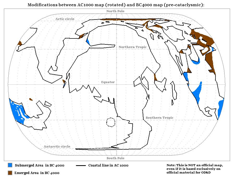
In his own words from his post (#40) at the time:
…a map showing the modifications of coastline and continents after the Great Rain of Fire. I drew this map comparing the coastlines shown in the HW pre-cataclysmic map with the modern coastlines; then I added these modifications to the map of ‘rotated’ Mystara (which is based on the modern shape of continents) I calculated.
This map is therefore the stepping stone between the two different versions of Michele’s precataclysmic Mystara. If you remember, the first showed the modern continents repositioned to their ancient positions, while the second included changes to the landmasses, with land bridges in some places and submerged areas in others. As Michele’s key explains, the brown “emerged areas” are land bridges that were present in 4000 BC, but submerged by 1000 AC, while blue “submerged areas” show modern lands that were beneath the seas in 4000 BC.
Fan-made Map by Michele Carpita (August 2005)
by Michele Carpita, August 2005
This is an original map created by one of Mystara’s excellent fan cartographers. For more information on the cartographer, including a gallery of all their maps, see also Appendix M: Mappers of Mystara.
Sources
- Hollow World Campaign Set (1990) (PDF at DriveThruRPG)
- Outer World Planetary Map
- Outer World Precataclysmic Map
Fan Sources
- LoZompatore’s Mystara (August 2005)
- LoZompatore’s Precataclysmic Mystara (July 2005)
- Blackmoor and the Broken Lands thread at the MMB, preserved at the Vaults of Pandius (October 2005)
- Blackmoor and Pre-Cataclysmic Mystara at the Vaults of Pandius (October 2005)
References
- All of Michele’s maps at the Atlas of Mystara
- Michele’s entry in Appendix M: Mappers of Mystara (upcoming)
- Michele’s author page at the Vaults of Pandius
Chronological Analysis
This is a fan-made map. It was published in August 2005. The updated Atlas version of this map is not yet available. See also Appendix C for annual chronological snapshots of the area. For the full context of this map in Mystara’s publication history, see the upcoming Let’s Map Mystara 2005.
The following lists are from the Let’s Map Mystara project. Additions are new features, introduced in this map. Revisions are changes to previously-introduced features. Hex Art & Fonts track design elements. Finally, Textual Additions are potential features found in the related text. In most cases, the Atlas adopts these textual additions into updated and chronological maps.
Under Construction! Please check back again soon for updates.
Additions
- XXX —
Revisions
- XXX —
Hex Art & Fonts
- Hex Art —
- Fonts —
")
")
")