
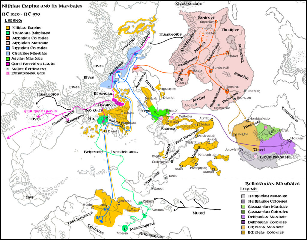
LoZompatore’s Nithian Expansion v2
This map was a follow-up to LoZompatore’s Nithian Expansion v1 from January 2006. It was also a work-in-progress, though as of this writing this remains the most up-to-date version available. Michele provided the key in his post to The Piazza at the time:
Orange: Nithian empire and colonies
Pale red: Nithian-derived people (Traldars, Minroths and Milenians; I added also Vacros and Cathos islands as Traldar settlements, but this is just a speculation of mine)
Pale blue: Hutaakan civilisation (linked to the Nithians thanks to the Immortal Pflarr)
Blue dots: Alphatian settlements (Nithian allies, accordingly to HW:KoN supplement) as of BC1000 (Sundsvall, Aasla, Helskir, Ar, Blackheart, Citadel)
He also provided some detail for the colonies depicted on his map, for which see the thread at The Piazza, or his article archived at the Vaults of Pandius.
Fan-made Map by Michele Carpita (September 2008)
This is an original map created by one of Mystara’s excellent fan cartographers. For more information on the cartographer, including a gallery of all their maps, see also Appendix M: Mappers of Mystara.
Work in progress map: This map is incomplete. It appears here in the most recent state available, but it may be missing certain elements.
Sources
- MSOLO2 Maze of the Riddling Minotaur (1983) (PDF at DriveThruRPG)
- X8 Drums on Fire Mountain (1984) (PDF at DriveThruRPG)
- M5 Talons of Night (1987) (PDF at DriveThruRPG)
- GAZ1 The Grand Duchy of Karameikos (1987) (PDF at DriveThruRPG)
- GAZ2 The Emirates of Ylaruam (1987) (PDF at DriveThruRPG)
- GAZ4 The Kingdom of Ierendi (1987) (PDF at DriveThruRPG)
- GAZ5 The Elves of Alfheim (1988) (PDF at DriveThruRPG)
- GAZ10 The Orcs of Thar (1989) (PDF at DriveThruRPG)
- Dawn of the Emperors (1989) (PDF at DriveThruRPG)
- Hollow World Campaign Set (1990) (PDF at DriveThruRPG)
- HWR2 Kingdom of Nithia (1991) (PDF at DriveThruRPG)
- Red Steel (1994) (PDF at DriveThruRPG)
- Savage Baronies (1995) (PDF at DriveThruRPG)
- And others…
Fan Sources
- LoZompatore’s Nithian Expansion v1 (January 2006)
- LoZompatore’s Brun Base Map
- Re: [Ancient Civilizations] Extent of the Nithian Empire post at The Piazza (September 2008)
- Extent of the Nithian Empire by Michele Carpita at the Vaults of Pandius (September 2008)
References
- All of Michele’s maps at the Atlas of Mystara
- Michele’s entry in Appendix M: Mappers of Mystara (upcoming)
- Michele’s author page at the Vaults of Pandius
Chronological Analysis
This is a fan-made map. It was published in September 2008. The updated Atlas version of this map is not yet available. See also Appendix C for annual chronological snapshots of the area. For the full context of this map in Mystara’s publication history, see the upcoming Let’s Map Mystara 2008.
The following lists are from the Let’s Map Mystara project. Additions are new features, introduced in this map. Revisions are changes to previously-introduced features. Hex Art & Fonts track design elements. Finally, Textual Additions are potential features found in the related text. In most cases, the Atlas adopts these textual additions into updated and chronological maps.
Under Construction! Please check back again soon for updates.
Additions
- XXX —
Revisions
- XXX —
Hex Art & Fonts
- Hex Art —
- Fonts —

")
")
")