
LoZompatore’s Northeastern Brun
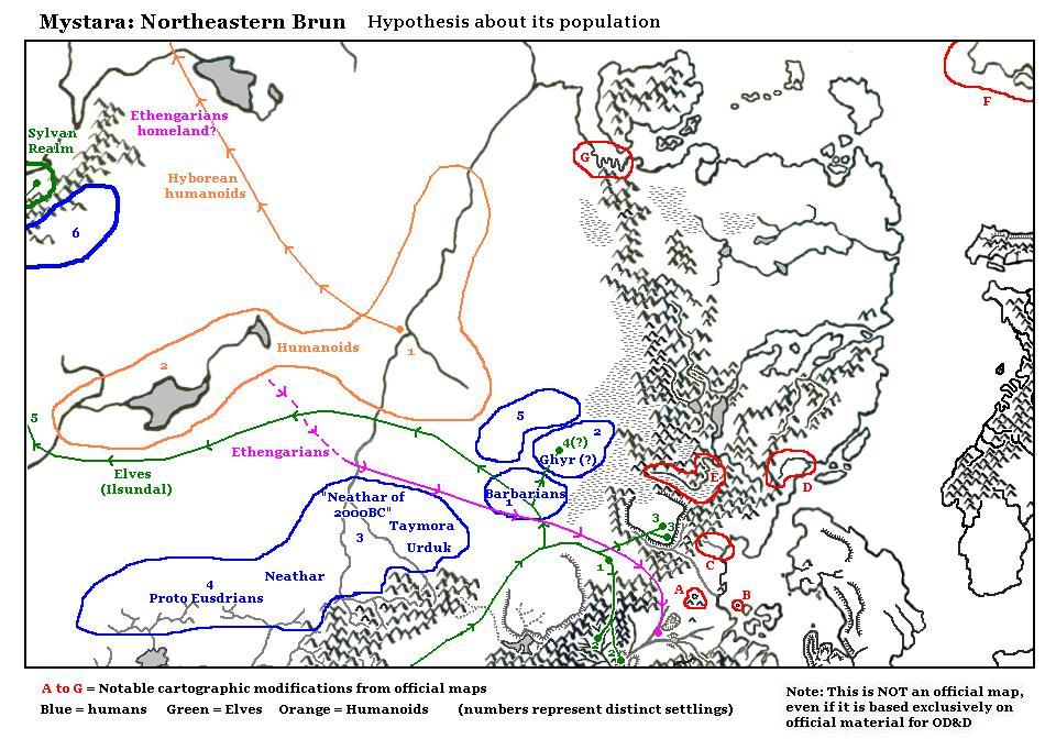
This was one of Michele’s last maps of 2005, his inaugural year of Mystaran mapping. In it, he presents various ideas about populations in Northwestern Brun, including some of the more debated cultures, such as Ghyr.
It was also the best view yet (at the time) of his new base map, and he spent some effort highlighting some of the changes he had implemented — here marked “notable cartographic modifications from official maps” and circled in red on the map. Each of these has an identifying letter from A to G, although there doesn’t seem to be a key explaining the changes.
Looking at the adaptations, A seems to be the Red Fangs and Lake Erid from X13; B is the Isle of Narvendul from GAZ7; C is the Heldland River; D and E are rivers added to Norwold; F is the isle north of Alphatia from CM1 (which was conflated with Qeodhar in earlier projects); and G is a stretch of jagged coastline southwest of Frosthaven.
If anyone has any ideas for the missing sources, or more information on these changes, please feel free to comment below. I will add any new information to this article.
Fan-made Map by Michele Carpita (December 2005)
This is an original map created by one of Mystara’s excellent fan cartographers. For more information on the cartographer, including a gallery of all their maps, see also Appendix M: Mappers of Mystara.
Sources
- CM1 Test of the Warlords (1984) (PDF at DriveThruRPG)
- XL-1 Quest for the Heartstone (1984) (PDF at DriveThruRPG)
- X13 Crown of Ancient Glory (1987) (PDF at DriveThruRPG)
- GAZ7 The Northern Reaches (1988) (PDF at DriveThruRPG)
- And others…
Fan Sources
- ?
References
- All of Michele’s maps at the Atlas of Mystara
- Michele’s entry in Appendix M: Mappers of Mystara (upcoming)
- Michele’s author page at the Vaults of Pandius
Chronological Analysis
This is a fan-made map. It was published in December 2005. The updated Atlas version of this map is not yet available. See also Appendix C for annual chronological snapshots of the area. For the full context of this map in Mystara’s publication history, see the upcoming Let’s Map Mystara 2005.
The following lists are from the Let’s Map Mystara project. Additions are new features, introduced in this map. Revisions are changes to previously-introduced features. Hex Art & Fonts track design elements. Finally, Textual Additions are potential features found in the related text. In most cases, the Atlas adopts these textual additions into updated and chronological maps.
Under Construction! Please check back again soon for updates.
Additions
- XXX —
Revisions
- XXX —
Hex Art & Fonts
- Hex Art —
- Fonts — Georgia.
")
")
")