
LoZompatore’s Norwold, 24 miles per hex
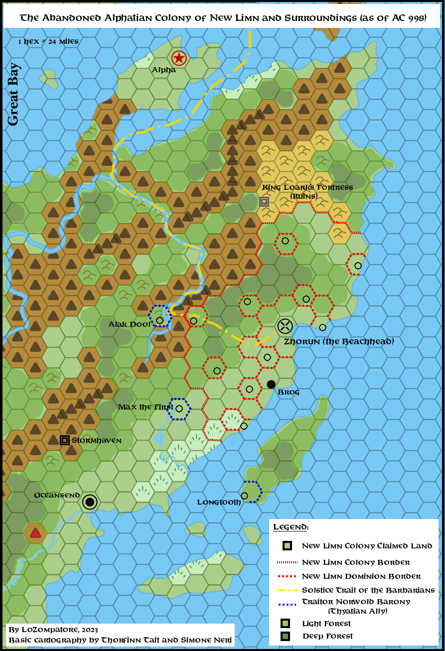
Michele made this map to illustrate a theory about the Beachhead marked in M2, proposing that it was the site of an abandoned Alphatian colony. In exactly the way we have all come to expect from Michele from his years of work on Mystara, he deftly brought together information and hints from numerous sources. He assembled the evidence to point to previous settlements at that location — not just the Alphatians, but also the Alatians as well as the Horde of King Loark.
All in all, Michele’s theory leveraged the rich history of the setting to add some useful details to this area of Norwold. From my perspective, one of the best parts is that since its history, the main addition to 1000 AC is ruins and other remnants of previous settlement. So it doesn’t necessarily have to affect whatever else is present here in 1000 AC — of which there are indeed multiple versions in the community, as opinions have differed over the years over the placement of Norwold dominions.
Fan-made Maps by Michele Carpita (March 2025)
by Michele Carpita, March 2025
This is an original map created by one of Mystara’s excellent fan cartographers. For more information on the cartographer, including a gallery of all their maps, see also Appendix M: Mappers of Mystara.
Sources
- CM1 Test of the Warlords (1984) (PDF at DriveThruRPG)
- M2 Vengeance of Alphaks (1986) (PDF at DriveThruRPG)
- GAZ10 The Orcs of Thar (1989) (PDF at DriveThruRPG)
- Dawn of the Emperors (1989) (PDF at DriveThruRPG)
- Hollow World Campaign Set (1990) (PDF at DriveThruRPG)
- Poor Wizard’s Almanac II (1993) (PDF at DriveThruRPG)
Fan Sources
- Zendrolion’s Norwold, 24 miles per hex
- A lost Alphatian colony at the Beachhead in Norwold discussion thread at The Piazza (March 2025)
- A lost Alphatian colony at the Beachhead in Norwold by Michele Carpita at the Vaults of Pandius (March 2025)
References
- All of Michele’s maps at the Atlas of Mystara
- Michele’s entry in Appendix M: Mappers of Mystara (upcoming)
- Michele’s author page at the Vaults of Pandius
Chronological Analysis
This is a fan-made map. It was published in June 2021. The updated Atlas version of this map is not yet available. See also Appendix C for annual chronological snapshots of the area. For the full context of this map in Mystara’s publication history, see the upcoming Let’s Map Mystara 2021.
The following lists are from the Let’s Map Mystara project. Additions are new features, introduced in this map. Revisions are changes to previously-introduced features. Hex Art & Fonts track design elements. Finally, Textual Additions are potential features found in the related text. In most cases, the Atlas adopts these textual additions into updated and chronological maps.
Under Construction! Please check back again soon for updates.
Additions
- XXX —
Revisions
- XXX —
Hex Art & Fonts
- Hex Art —
- Fonts —
")
")
")