
LoZompatore’s Sea of Dread
Michele posted a version of this map in JTR’s Thanegioth Archipelago Project thread at the Wizards’ Mystara Message Board back in 2006. The first file was partially corrupted, but the version below is uncorrupted (or possibly fixed), dating from November 2008. I believe that the content was the same.
In fact the original map was a little older, as Michele noted that he had posted it first at the Italian MMB.
The content was classic LoZompatore: a plethora of official sources distilled into a single map, in this case a marked-up version of PC3’s Sea of Dread overview map. He listed an extensive list of sources at the top of the map, and even made suggestions for further additions in his post at the MMB:
If you have AC 10 Bestiary of Dragons and Giants, maybe you can place the island of the storm giants somewhere SE of Termite Atoll. We also placed the adventure about Thyralax the dragon in the central island of the archipelago (the second big island east of the isle of dread), due to the presence of koprus and to the large NS extension of the area described in the adventure.
We thought also about placing the old Belcadiz home (naming it “isle of Alvar”) in the easternmost island of Thanegioth Archipelago, but this is not so much canonical.
Fan-made Map by Michele Carpita (March 2006)
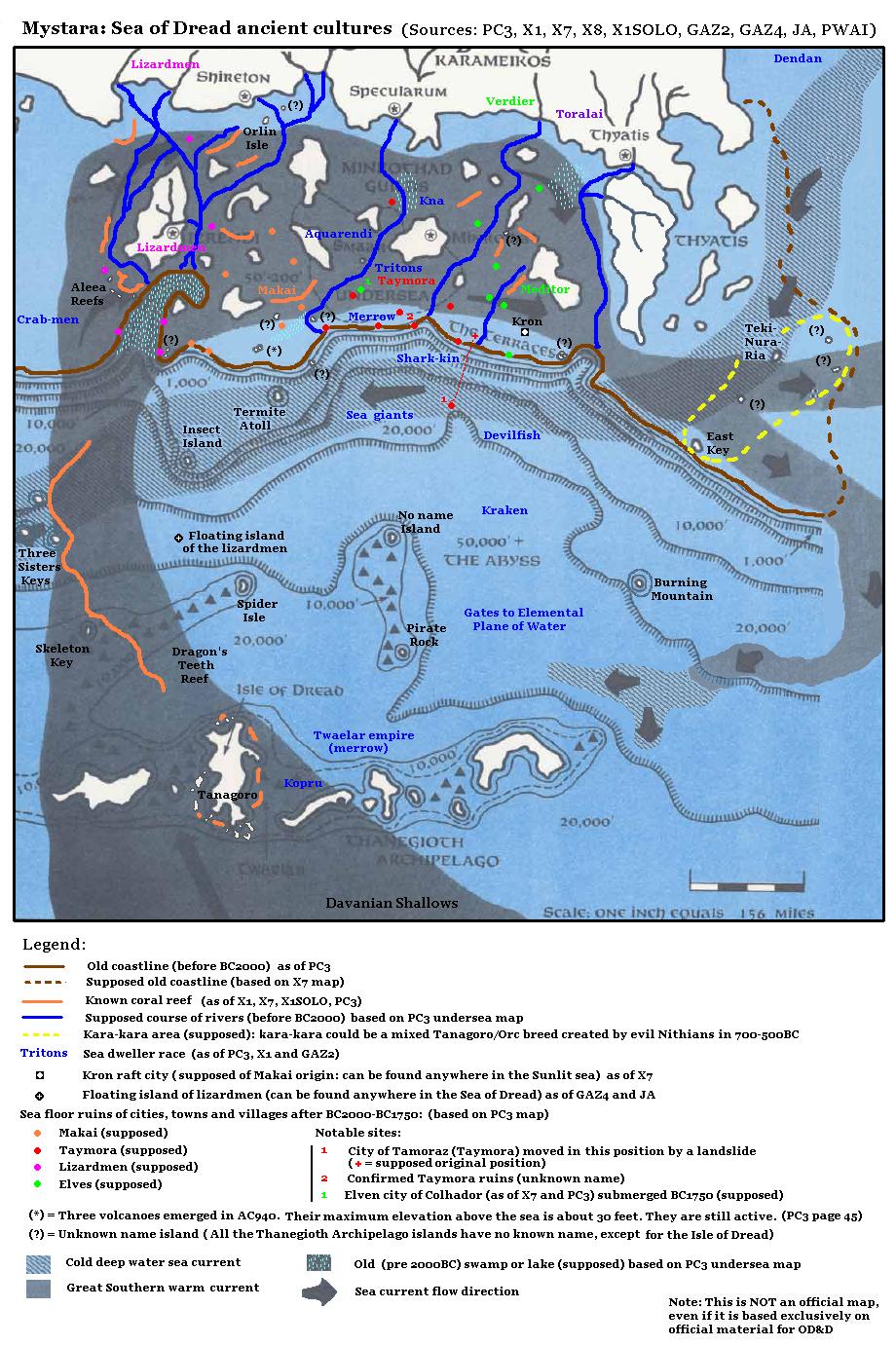
This is an original map created by one of Mystara’s excellent fan cartographers. For more information on the cartographer, including a gallery of all their maps, see also Appendix M: Mappers of Mystara.
Sources
- PC3 The Sea People (1990) (PDF at DriveThruRPG)
- X1 The Isle of Dread (1981) (PDF at DriveThruRPG)
- X7 The War Rafts of Kron (1984) (PDF at DriveThruRPG)
- X8 Drums on Fire Mountain (1984) (PDF at DriveThruRPG)
- XSOLO Lathan’s Gold (1984) (PDF at DriveThruRPG)
- GAZ2 The Emirates of Ylaruam (1987) (PDF at DriveThruRPG)
- GAZ3 The Principalities of Glantri (1987) (PDF at DriveThruRPG)
- GAZ4 The Kingdom of Ierendi (1987) (PDF at DriveThruRPG)
- Poor Wizard’s Almanac (1992) (PDF at DriveThruRPG)
- Joshuan’s Almanac (1995) (PDF at DriveThruRPG)
Fan Sources
- Thanegioth Archipelago Project MMB discussion thread archived here at the Atlas (March 2006)
- Sea of Dread ancient cultures by Michele Carpita at the Vaults of Pandius (March 2006)
References
- All of Michele’s maps at the Atlas of Mystara
- Michele’s entry in Appendix M: Mappers of Mystara (upcoming)
- Michele’s author page at the Vaults of Pandius
Chronological Analysis
This is a fan-made map. It was published in March 2006. The updated Atlas version of this map is not yet available. See also Appendix C for annual chronological snapshots of the area. For the full context of this map in Mystara’s publication history, see the upcoming Let’s Map Mystara 2006.
The following lists are from the Let’s Map Mystara project. Additions are new features, introduced in this map. Revisions are changes to previously-introduced features. Hex Art & Fonts track design elements. Finally, Textual Additions are potential features found in the related text. In most cases, the Atlas adopts these textual additions into updated and chronological maps.
Under Construction! Please check back again soon for updates.
Additions
- XXX —
Revisions
- XXX —
Hex Art & Fonts
- Hex Art —
- Fonts —
")
")
")