
LoZompatore’s Surshield, 24 miles per hex
The last of Michele’s Bellissaria provincial maps covered the southern province, Surshield. It extends from the far west to the far east, spanning the whole length of the island continent. Michele found quite a few things to add, and also tackled a double up of labels for the long mountain range. He explained all of this in detail in his MMB post:
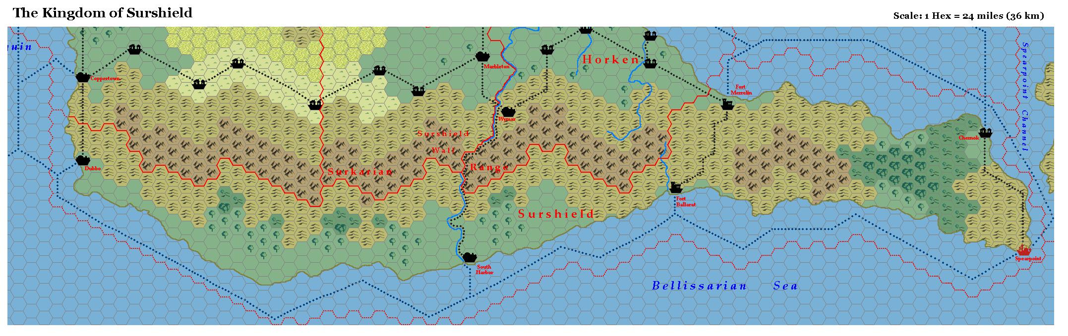
I added the road from South Harbor to Wymar in the kingdom of Horken (see). Notice that Surshield does not seem to have major roads in the E-W directions (distances are enormous, and the terrain is not very suitable for road building). The South Harbor-Wymar road is almost necessary, otherwise a merchant should have to sail around the long Spearpoint peninsula just to trade with the nearby kingdom of Horken.
I added the official village of Chernok (PWAIII), even if its position is not explicitly known. We just know from PWAIII that the village is relatively near to Spearpoint, and it is ransacked by Minaean pirates in AC1012. I placed Chernok along the Spearpoint Channel coastline, near the intersection of two major sea trade routes.
I changed some hills with wooded hills in the southern coast of Surshield, considering that precipitations along the southern coastline should be more abundant than the northern side of the Surkarian Range.
About the mountains: notice that the DoTE calls “Surkarian Range” the long mountain chain between Spearpoint and Dubbo, while the PWAs maps call the same region with the name “The Surshield Wall”. Instead of dropping one of these two names, I preferred to mantain the term “Surkarian Range” for the whole chain and to consider the term “Surshield Wall” as referred to a part of the range (possibly the highest or the steepest part of the Surkarian Range).
Fan-made Map by Michele Carpita (July 2006)
This is an original map created by one of Mystara’s excellent fan cartographers. For more information on the cartographer, including a gallery of all their maps, see also Appendix M: Mappers of Mystara.
Sources
- Dawn of the Emperors (1989) (PDF at DriveThruRPG)
- Wrath of the Immortals (1992) (PDF at DriveThruRPG)
- Poor Wizard’s Almanac (1992)
- Poor Wizard’s Almanac III (1994)
Fan Sources
- Thoughts about Bellissarian maps discussion thread at the MMB, archived at the Vaults of Pandius (July 2006)
- Thoughts about Bellissarian maps by Michele Carpita at the Vaults of Pandius (July 2006)
References
- All of Michele’s maps at the Atlas of Mystara
- Michele’s entry in Appendix M: Mappers of Mystara (upcoming)
- Michele’s author page at the Vaults of Pandius
Chronological Analysis
This is a fan-made map. It was published in July 2006. The updated Atlas version of this map is not yet available. See also Appendix C for annual chronological snapshots of the area. For the full context of this map in Mystara’s publication history, see the upcoming Let’s Map Mystara 2006.
The following lists are from the Let’s Map Mystara project. Additions are new features, introduced in this map. Revisions are changes to previously-introduced features. Hex Art & Fonts track design elements. Finally, Textual Additions are potential features found in the related text. In most cases, the Atlas adopts these textual additions into updated and chronological maps.
Under Construction! Please check back again soon for updates.
Additions
- XXX —
Revisions
- XXX —
Hex Art & Fonts
- Hex Art —
- Fonts —
")
")
")