
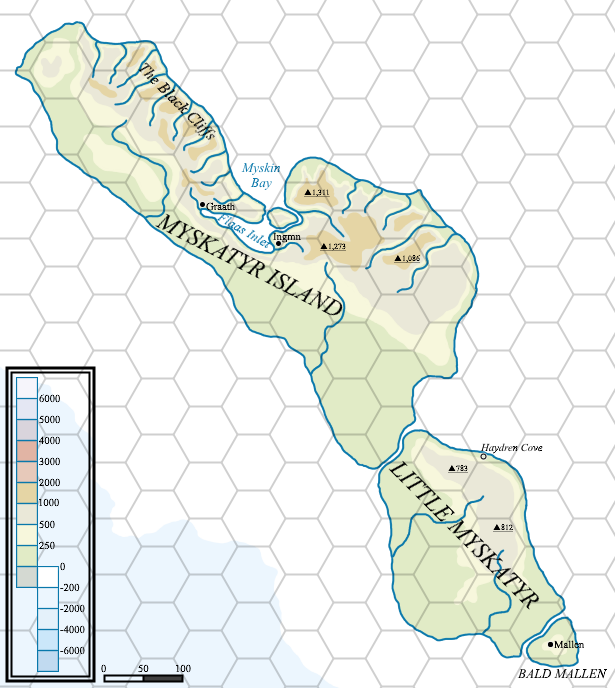
Mark’s Myskatyr Island, 24 miles per hex Topographic
Mark didn’t post much in the way of new maps in 2023. This is the only one I know of, but it’s a very interesting piece of work. He explained on his blog:
This is something I’ve been thinking about for a while, a more real world “atlas” style map.
I’m still working on a few ideas about how I want to portray some information, but here is a draft of Myskatyr Island, sat off the north-western coast of Thonia.
It would be two years until we would see the fruits of Mark’s efforts with this new topographical style.
Fan-made Map by Mark Howard (June 2023)
This is an original map created by one of Mystara’s excellent fan cartographers. For more information on the cartographer, including a gallery of all their maps, see also Appendix M: Mappers of Mystara.
Sources
- Dawn of the Emperors (1989) (PDF at DriveThruRPG)
Fan Sources
- Myskatyr Island – Style test at Mark’s web site (June 2023)
References
- All of Mark’s maps at the Atlas of Mystara
- Mark’s entry in Appendix M: Mappers of Mystara (upcoming)
- Mark’s author page at the Vaults of Pandius
Chronological Analysis
This is a fan-made map. It was published in May 2021. The updated Atlas version of this map is not yet available. See also Appendix C for annual chronological snapshots of the area. For the full context of this map in Mystara’s publication history, see the upcoming Let’s Map Mystara 2021.
The following lists are from the Let’s Map Mystara project. Additions are new features, introduced in this map. Revisions are changes to previously-introduced features. Hex Art & Fonts track design elements. Finally, Textual Additions are potential features found in the related text. In most cases, the Atlas adopts these textual additions into updated and chronological maps.
Under Construction! Please check back again soon for updates.


