
Mark’s Western Gulf of Hule, 8 miles per hex v1
Back in September 2020, Mark approached me with some questions about my work lining up the disparate parts of Brun. One of the areas he asked about was the Savage Coast. I had discovered problems with its alignment (for which see The Savage Dilemma in Appendix L), and proposed a solution involving a further 2º rotation as well as a reinterpretation of its scale to 22.9 miles per hex.
That much I had already posted about publicly as part of my work on Mystara 1985. But in fact there is also a knock-on issue with the later Voyage of the Princess Ark maps from Dragon Magazine. I have outlined the problem in Appendix L, in The Gulf of Hule Problem, but suffice it to say that while the continental map shows four “bumps” on the west coast of the Gulf of Hule, the Savage Baronies maps only provided three.
In other words, a significant section of coast was left out.
Although I revisited the discussion in late 2023 in a Patreon post, there was no further movement on the issues at that time.
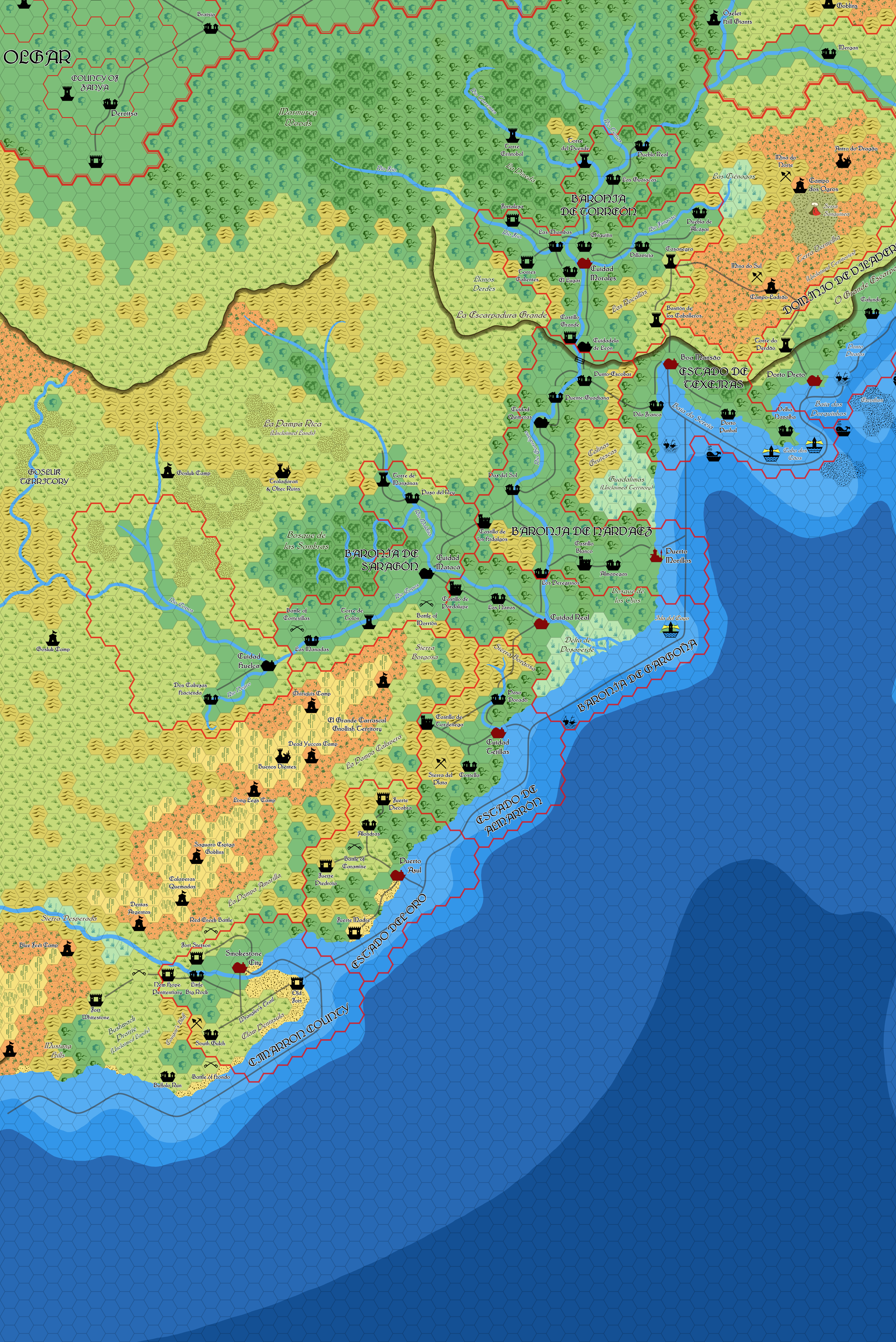
Then, in June 2025, Mark posted about the Gulf of Hule Problem at The Piazza, proposing three possible solutions — and including two maps to illustrate these ideas.
The map below corresponds with Mark’s second option, to insert a new barony between Almarrón and Cimmaron. He also produced a map for the third option, for which see its own post. Although his maps appeared rather complete, he described them as a thought experiment rather than a polished proposal.
Mark also provided us a sneak peek into his latest mapping system, including his new font as well as new artwork for escarpments. Moreover, it revealed that he had already completed significantly more of the world than he had shared publicly at that point — this was his first time posting a Savage Coast or Hule map, and yet it shows a high degree of completion throughout.
In short, as well as being a great proposal (or experiment) for fixing the Gulf of Hule problem, it also hinted that Mark would someday soon have much more to share with us.
Fan-made Map by Mark Howard (June 2025)
This is an original map created by one of Mystara’s excellent fan cartographers. For more information on the cartographer, including a gallery of all their maps, see also Appendix M: Mappers of Mystara.
Sources
- The Voyage of the Princess Ark Part 19: Hule!, Dragon #172 (August 1991)
- The Voyage of the Princess Ark Part 20: Raman’s holiday homework, Dragon #173 (September 1991)
- The Voyage of the Princess Ark Part 21: The Savage Baronies, Dragon #174 (October 1991)
- The Voyage of the Princess Ark Part 22: Arsenic and old mantillas, Dragon #175 (November 1991)
- The Voyage of the Princess Ark Part 23: Shoutout at South Gulch, Dragon #176 (December 1991)
Fan Sources
- Correspondence between Mark and Thorf (September 2020)
- The Gulf of Hule Problem at Patreon (December 2023)
- Gulf of Hule problem discussion thread at The Piazza (June 2025)
References
- All of Mark’s maps at the Atlas of Mystara
- Mark’s entry in Appendix M: Mappers of Mystara (upcoming)
- Mark’s author page at the Vaults of Pandius
Chronological Analysis
This is a fan-made map. It was published in June 2025. The updated Atlas version of this map is not yet available. See also Appendix C for annual chronological snapshots of the area. For the full context of this map in Mystara’s publication history, see the upcoming Let’s Map Mystara 2025.
The following lists are from the Let’s Map Mystara project. Additions are new features, introduced in this map. Revisions are changes to previously-introduced features. Hex Art & Fonts track design elements. Finally, Textual Additions are potential features found in the related text. In most cases, the Atlas adopts these textual additions into updated and chronological maps.
Under Construction! Please check back again soon for updates.
Additions
Revisions
Hex Art & Fonts
- Fonts — Lautenbach.
")
")
")