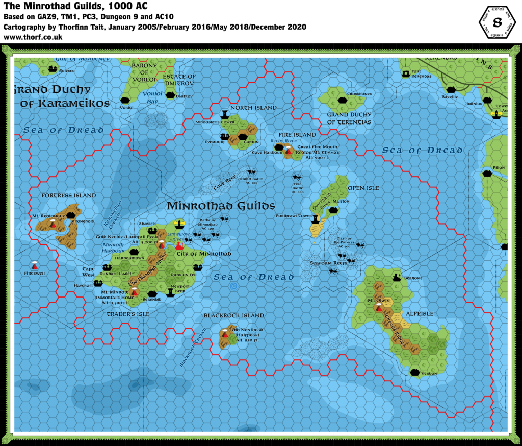
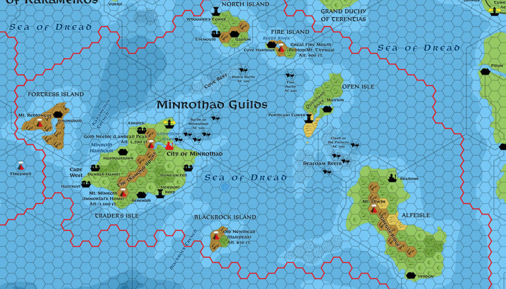
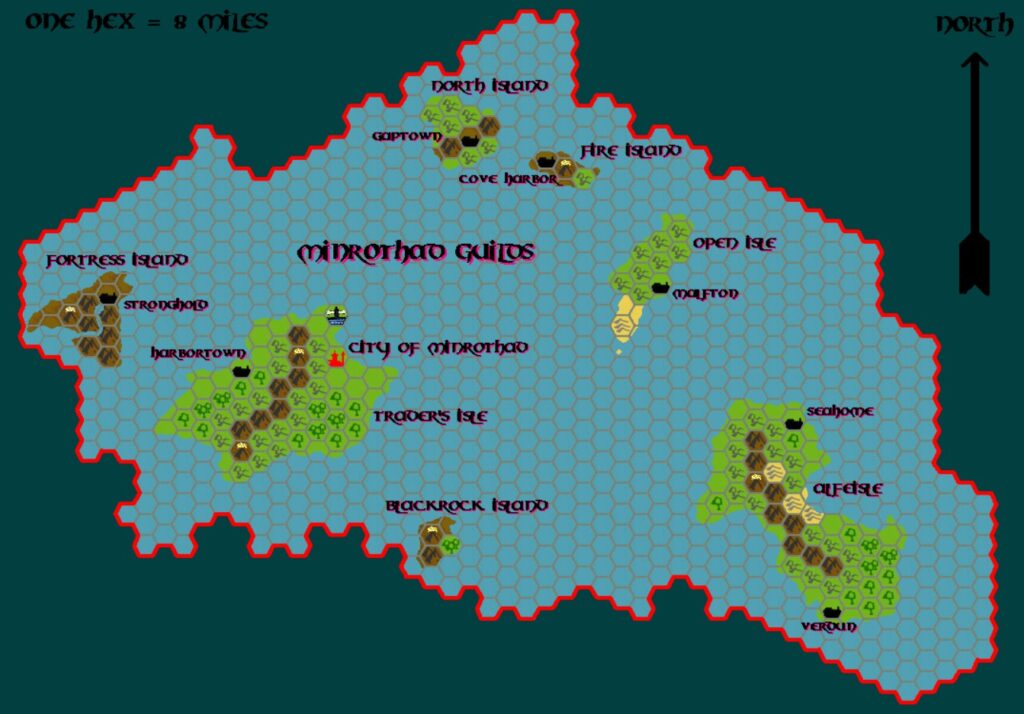
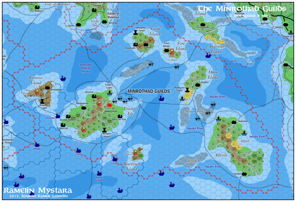
Minrothad, 8 miles per hex
Minrothad, a nation of island peoples, is organized into a close-knit confederation of craft and service guilds. The country is commonly called the Minrothad Guilds, as they are known in commerce with the world’s trading communities. The Minrothad Guilds are located in the Minrothad Isles, formerly called the Isles of Dread. The islands are in the Dread Sea south of Karameikos between Ierendi and Thyatis.
from GAZ9 The Minrothad Guilds, by Deborah Christian and Kim Eastland
Map (December 2020)
Sources
- GAZ9 The Minrothad Guilds (1988) (PDF at DriveThruRPG)
- Dawn of the Emperors (1989) (PDF at DriveThruRPG)
- TM1 The Western Countries (1989)
- TM2 The Eastern Countries (1989)
- PC3 The Sea People (1990) (PDF at DriveThruRPG)
- Rules Cyclopedia (1991) (PDF at DriveThruRPG)
- AC10 Bestiary of Dragons and Giants (1987) (PDF at DriveThruRPG)
- Dungeon Issue #9 The Djinni Ring (1988)
Comments
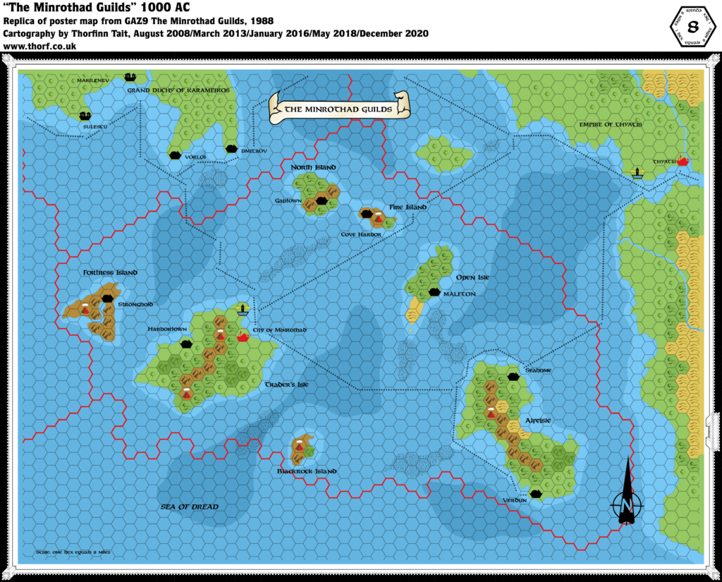
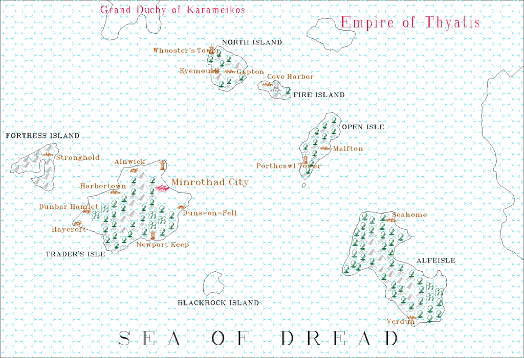
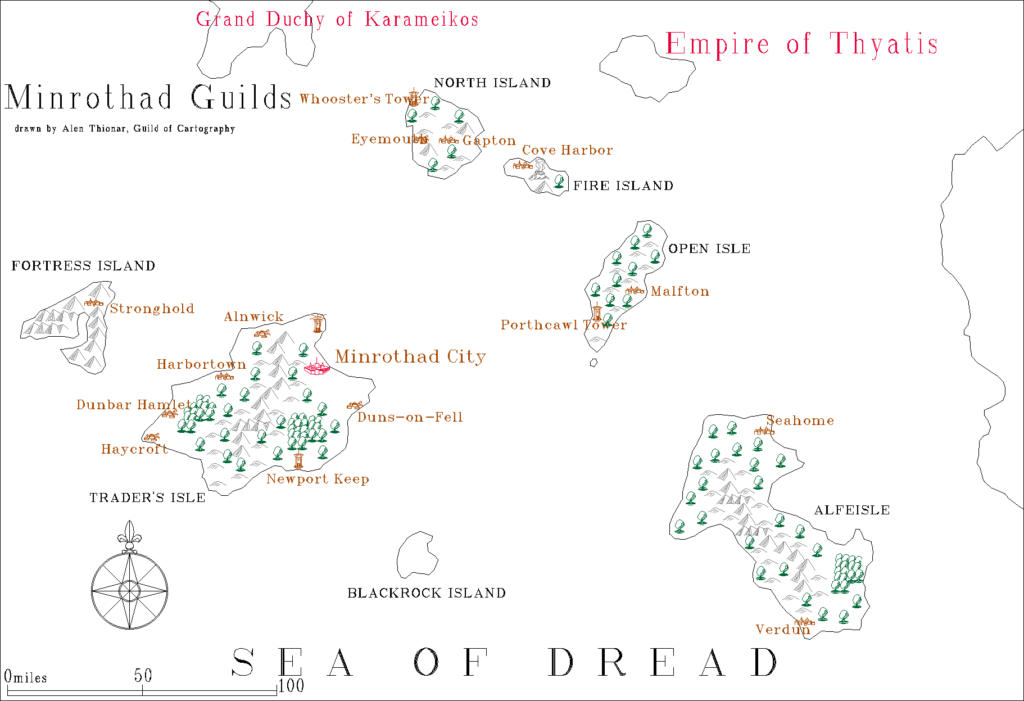
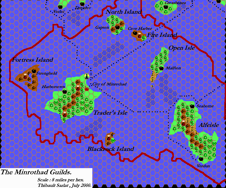
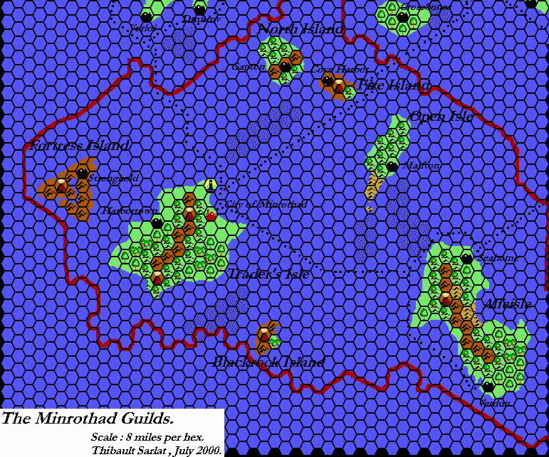
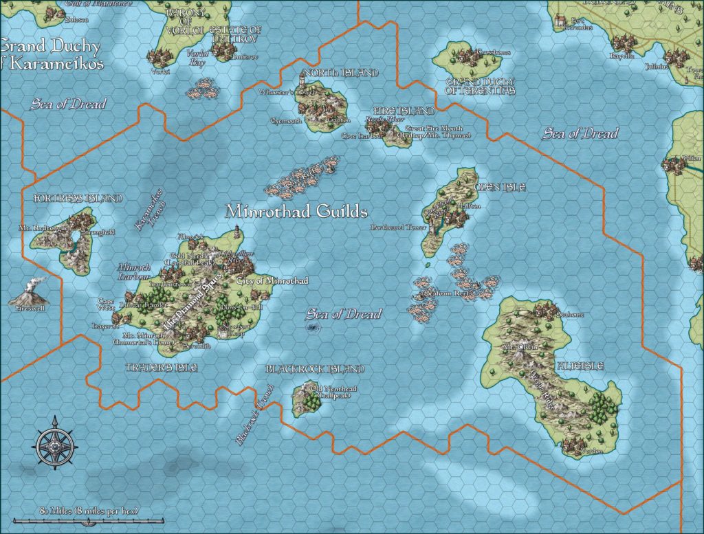
The map for GAZ9 The Minrothad Guilds (1988) was woefully under-developed. It shows very few settlements, cursory shipping lanes, no trails, no rivers, and in fact nothing much at all other than the land itself. In contrast, the Gazetteer itself has extensive descriptions of the geography of the area. The Trail Maps also expanded upon Minrothad, though not necessarily in the same ways the Gazetteer text did. PC3 provided some extra details, but less than for neighbouring Ierendi, since not all of Minrothad’s territory was shown.
Notes
- Coastal Waters – TM1 and TM2 redrew Minrothad’s coastal waters, adding more detail and placing shallow water under most of the reefs (which GAZ9 had placed mostly over deeper water). PC3 then extensively revised shallow and deep water throughout the area, providing depth measurements. The Atlas considers PC3 the best source for these.
- Gapton – labelled as Gaptown on GAZ9’s map. However, two text references (Player’s Booklet page 5, DM’s Booklet page 6) have Gapton while the Gaptown spelling is nowhere to be found in GAZ9’s text. TM1 also used Gapton, perhaps suggesting that Gaptown was an error. The Atlas is treating it as such, and uses the spelling Gapton.
- Gregus Ridge – the name of Alfeisle’s mountain range is given on page 49 of GAZ9’s DM’s Booklet.
- Hermian – this small village on Blackrock Island is mentioned on page 54 of GAZ9’s DM’s Booklet. However, it has not been added to the map, since doing so would mean the loss of the lone heavy forest hex. This village can be added to larger scale maps of the island.
- Islands — PC3 added a number of minor islands to the seas south and southwest of Ierendi. The updated map includes these, and also adds shallow water around them.
- Labels — as with Ierendi, Minrothad’s original GAZ9 poster map was rather sparse when it came to labels. Only the islands and settlements were labelled, leaving other terrain nameless. Many labels were added to the area on TM1 and TM2, including labels for the volcanoes, reefs, rivers and bays.
- Lighthouses —
TM1 added the lighthouse to Trader’s Isle.GAZ9 showed a single lighthouse on Trader’s Isle. Amazingly, this is the only lighthouse marked on any of Minrothad’s maps. - Lithwillow River – this river is referenced on page 4 of GAZ9’s Player’s Booklet and again on DM’s Booklet pages 45-46: “The Lithwillow drains down from Landfall Peak, into the caldera, then downhill again to the sea.” The updated map has the river marked according to this description.
- Minroth Harbor – the name of the harbour upon which Harbortown is built is given on page 48 of GAZ9’s DM’s Booklet.
- Mountain names – while none of the volcanoes were labelled on GAZ9’s map, many were mentioned in the text: Landfall Peak, Immortal’s Home, Halfpeak, Mt. Olwin, Mt. Redtongue, Redtop and Mt. Thymas. (The latter two are in fact the same volcano, on Fire Island.) TM1 and TM2 also added many individual mountains not found on the Gazetteer maps, but in Minrothad the new mountain names were different from those provided in GAZ9’s text. Halfpeak became Old Nenthead, Redtop/Mt. Thymas became Great Fire Mouth (giving it a third name), Landfall Peak became Gold Needle, and Immortal’s Home became Mt. Minroth. The Atlas considers these local variations, any of which can be used interchangeably. All of the altitudes come from TM1 and TM2.
- Open Isle – described in GAZ9 as “flat and treeless” (page 5), the map nevertheless depicts this island as hilled and mostly covered with forests! Since it’s home to Minrothad’s halflings, the forested hills seem quite appropriate, and have therefore been left as is on the updated map.
- Quickhand River – Open Isle’s river is referred to on page 48 of GAZ9’s DM’s Booklet. The version in this atlas is merely an educated guess as to the river’s course.
- Reedy River – page 54 of GAZ9’s DM’s Booklet describes this river on Fire Island.
- Reefs — as mentioned in the note for coastal waters, GAZ9’s map had reefs over deeper water. This is rather illogical, and TM1 fixed the error. PC3 further built upon this, redrawing the reefs and making sure they were mostly over shallow water.
- Sea battles — PC3 shows many shipwreck symbols for sea battles. Since these are distinct from the trident symbol for “underwater battles”, they have been added to the updated Minrothad map. Some of the battle names may not be relevant to the surface world, but unless they were clearly placed on a trident symbol, I have included them for the sake of completeness.
- Serendib — Dungeon 9’s The Djinni Ring talks of this settlement: “After many days of travel across the hot sands, you began the long sea journey home, eventually landing in the port of Serendib, one of the cities of the Minrothad Guilds.” AC10’s Isle of the Storm Giants also refers to it: “The scenario begins in the port of Serendib, which may be placed in the DM’s campaign world or set in the eastern region of the D&D game world’s wilderness overseen by the Minrothad guilds.” Also, “The port of Serendib has long been a prosperous trading center where exotic goods from around the world are offered for sale and barter. Much of the credit for the city’s bustling commerce lies with the effective guidance of its powerful merchants’ guild, which possesses trading agreements with sovereigns and business people from many foreign lands.” There has been some discussion about where to place Serendib based on these references. Simone Neri outlined three possible placements in a sidebar to his article on Minrothaddan demography in Threshold Issue #3 (page 160). The options were (1) Serendib is an alternate name for Harbourtown, (2) it’s a new settlement on the coast of Trader’s Isle, and (3) it’s a new settlement on Alfeisle’s western coast. The Atlas has provisionally adopted option (2), placing the settlement as a large town on the bay west of Newport Keep.
- Shipping lanes — GAZ9 showed a cursory shipping network, which TM1 later expanded upon. A note in Dawn of the Emperors DM’s Sourcebook page 22 provides guidance for adding another: “…the Minrothad-to-Gapton route continues on to Terentias and then to Kerendas.” I have therefore added a route coming from Gapton up round Terentias to Crossroads.
- Verdon – Alfeisle in the Minrothad Guilds has two settlements. The northern one is called Seahome, but the southern one is actually referred to by two variations of the same name: Verdun and Verdon. Verdun appears on all the official maps (GAZ9’s map, GAZ9’s trading map, Wrath of the Immortals’ 24 mile per hex map, and TM2), but only has two references in GAZ9’s text, one of which is in the table of ports. Verdon appears as the label on only one map (the town map), but is the norm in GAZ9’s text, appearing no less than seventeen times. Given the historical significance of the name “Verdun” as a World War I war site, the Atlas considers “Verdon” the more appropriate name.
- Villages — GAZ9 showed no villages anywhere on its map. TM1 added a few on Trader’s Isle and North Island, but unfortunately TM2 failed to add any more to Alfeisle, despite its size.
- Whirlpools — the whirlpools shown on PC3’s map clearly also affect the surface world, and have therefore been added to the updated map.
References
- Minrothad at the Vaults of Pandius
- Minrothad map thread at The Piazza
- Mapping Issues: How to Mark Capitals at The Piazza
Thanks to:
Eric Anondson, Michele Carpita (LoZompatore), Hervé Musseau (Andaire), Simone Neri (Zendrolion), Andrew Theisen (Cthulhudrew)

9 February 2016 @ 8:48 pm
The updated map of Minrothad really looks beautiful and filled with intriguing details! Some comments:
1) Shouldn’t Seahome symbol be updated from “town” to “city”? According to GAZ9, the water elves’ capital has a population of 20,000 after all.
2) I have a doubt about Serendib. From the short description of the city found in AC10, we learn that Serendib is a trading hub for exotic goods from around the world. In my opinion, the city should at least be found on a major trade route. The location you put it seems good since it’s at the northern end of the trade route which crosses the Sea of Dread via the Thanegioth Archipelago from (supposedly) Davania. The only thing I’d add is a sea route connecting the city to the trade lane.
9 February 2016 @ 10:30 pm
1) Good catch!
2) I’m not a fan of the idea of this trade route, personally… I view the Sea of Dread as a very forbidding and dangerous area that traders would generally avoid, so I doubt that this would be a commonly used trade route — it’s just too risky.
About Serendib’s location… This seems like the only possible location on Trader’s Isle that doesn’t crowd the other stuff that’s already there. Well, there’s also the forest hex between Duns-on-Fell and Newport Keep. But the little bay southwest of Newport Keep seems like a better location, don’t you think?
I’ll link it up to the trade routes once the location is locked in. 😉
10 February 2016 @ 12:19 am
About trade routes through the Sea of Dread, since canon sources features sea lanes linking both Minrothad and Ierendi with Thanegioth, I suppose they should be somehow, if infrequently, used. I have tried to give this an explanation in the last attachment of my “History of Minrothad and Ierendi” in Threshold #6, and there’s also an excellent article of Michele in Threshold #4 about this.
Anyway, since individual views may differ, it’d be better to choose a solution for Serendib which makes its location consistent with the canon description of the city while still making it usable and acceptable by any DM. All in all, the best solution to leave GAZ9 mostly untouched would be having Serendib as the patois-name of Harbourtown (which would be “Serendib” translated into Thyatian). Note that the description says that Serendib has in fact been a prosperous port and exotic good trade hub since a long time – which means that we should find for the town a location which really makes for this description (good routes not contested or shared with other towns). Harbourtown has been one of the most powerful Guild towns for a long time, and its guilds specialize in exotic merchandise, so this seems to match.
For these reasons, a second-hand location is then unwelcome, in my opinion. Nevertheless, if the “additional city” option is preferred, I’d stick with a location along the coast which runs from the southernmost tip of Trader’s Isle to Newport Keep – after all a number of real-history trade cities prospered on coasts which had hills or mountains at their back (think of Genoa, Amalfi, or Ragusa, just to cite a few we have in Italy and surroundings). Obviously, to make this location viable we have to assume that a flourishing trade comes to it through the sea routes shown on the map.
15 November 2020 @ 3:53 pm
Regarding Serendib’s note. At the end you mention “As a result of this reference and the one from Dungeon 9, and as per Michele Carpita’s suggestion, Serendib has been placed as a town on Alfeisle.”
I think your note for Serendib might need updating to match Simone Neri’s comment.
17 November 2020 @ 7:23 pm
Good catch! The only question is how it should be updated.
Reading back over the comments here and at The Piazza thread for this map, it seems that both I and Simone concluded that having Serendib as an alternate name for Harbourtown would be the best solution.
In that case, I should update the map as well as the note, removing the separate settlement icon and placing “(Serendib)” as an alternate after “Harbourtown”. It occurs to me that this would be far from the first place in Minrothad to have double names, so it seems rather fitting! 😉
There is one caveat here: as this map has been up for some time, other maps now include Serendib as a town on the southern coast of Trader’s Isle, based on my map. Because of this, perhaps it would be most appropriate to take it that the ship has already sailed on this issue, and accept Serendib as a new town rather than an alternate for Harbourtown.
For now, I will update the note to reflect the current map, but I’m open for discussion on further change.
What do you think?