Moldvay & Schick’s Known World
The origin of the Known World lies in X1 The Isle of Dread (1981), by David Cook and Tom Moldvay. The iconic two-page map, along with a further one and a half pages of descriptions, sketched out the heart of the setting. At this early stage, it wasn’t even called the “Known World”, but simply “The Continent”; the “Known World” monicker did not appear until years later, and was only adopted as the setting’s name partway through the Gazetteer era.
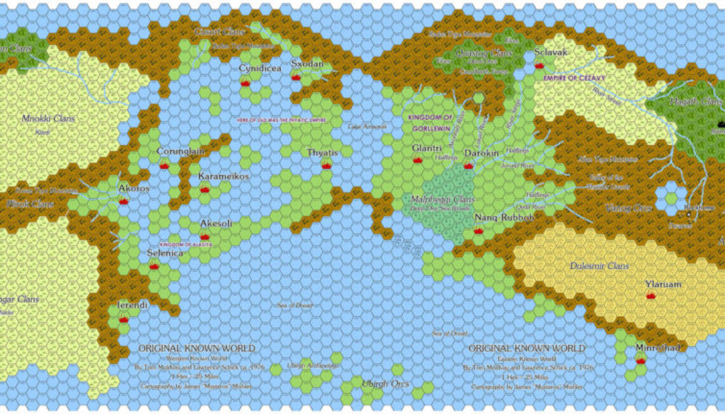
But before all that, and even before X1, there was another Known World: the home campaign setting of Tom Moldvay and Lawrence Schick, as revealed by Schick in 2015. The landforms bear no resemblance to Mystara’s Known World, as X1’s map was drawn completely anew. But the place names, which Schick provided in a document alongside the unlabelled map, are strikingly familiar to any Mystara fan.
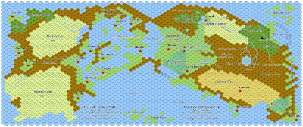
Within a day of Schick’s post, longtime Mystara fan James “Mystaros” Mishler produced a replica of Moldvay and Schick’s map, calling it the Original Known World, and placing all of the labels in their intended places on the map. He then interviewed Schick extensively about the map and the setting, for which see References below.
In terms of Mystara history, this map is the proto-Known World, containing many of the names that would go on to become iconic parts of the setting.
Replica Map by James Mishler (March 2015)
This map is not part of Mystara. Instead, it presents an alternate dimension or other planar location.
Maps by Tom Moldvay and Lawrence Schick (c. 1976)
Thanks to Lawrence Schick for giving permission to repost these maps
Sources
- Original work
References
- The “Known World” D&D Setting: A Secret History (2015) by Lawrence Schick at Black Gate
- The Original Known World (2015) by James Mishler at Adventures in Gaming v2
- Lawrence Schick Answers Q’s on the Original Known World (2015) by James Mishler at Adventures in Gaming v2
- Another Round of Q’s Answered by Lawrence Schick (2015) by James Mishler at Adventures in Gaming v2
- Final Round of Q’s Answered by Lawrence Schick (2015) by James Mishler at Adventures in Gaming v2
- All of James’s maps at the Atlas of Mystara
- James’s entry in Appendix M: Mappers of Mystara
- James’s author page at the Vaults of Pandius
Chronological Analysis
This is map 0. It was created c. 1976, and first published online in 2015. For the full context of this map in Mystara’s publication history, see Let’s Map Mystara 1981 Part I.
The following lists are from the Let’s Map Mystara project. Given the irregular nature of this map and its associated documents, I have skipped the usual categories and only list Additions (new features, introduced in this map) followed by an Analysis.
Additions
The map itself is entirely different from and incompatible with all later Known World maps. But it nonetheless includes many names that were incorporated into the Known World — as well as many that were not. These lists include both types; those which appear later in Mystara are in bold.
- Cities: Akesoli, Akoros, Corunglain, Cynidicea, Darokin, Dwyrain, Gugonix, Glantri, Ierendi, Karameikos, Keraptis, Minrothad, Nanq-Rubbob, Nolo-Nolo, Rockhome, Ruins of Tentrumtoom, Sclavak, Selenica, Sxodan, Thyatis, Ylaruam
- Nations: Kingdom of Alasiya, Empire of Cezavy, Kingdom of Gorllewin, Thyatic Empire
- Tribes: Atruaghin Clans, Capheron Clans, Cusort Clans, Dulesmir Clans, Ethengar Clans, Grilth Orcs, Hagath Clans, Heldann Clans, Kobblekem Orcs, Malpheggi Clans, Mnokki Clans, Plirok Clans, Quastog Clans, Ubirgh Orcs, Vanog Orcs
- Mountains: Altan Tepe Mountains, Kovan Tepe Mountains, Radan Tepe Mountains, Valley of the Thunder Lizards
- Terrain: Lake Amsorak, Axhonief River, Canolbarth Forest, Jorund River, Luxed River, Qeda River, River Streel, Sea of Dread, Ubirgh Archipelago
Analysis
A few of these made their way into the Known World unchanged, while many were reassigned to something different:
- Cities that remained cities: Akesoli, Corunglain, Cynidicea, Selenica
- Akoros remained a city but became Akorros
- Many cities became the capitals of their own countries with the same names: Darokin, Glantri, Ierendi, Minrothad, Thyatis, Ylaruam
- Karameikos became a country rather than a city
- “Tribes” changed from largely humanoid to mostly human cultures: Atruaghin, Ethengar, Heldann
- Malpheggi became the name of a swamp
- Alasiya became the desert where Ylaruam is located (it’s interesting to note that the two are unrelated in the original map, although Ylaruam was already a desert capital)
Of the names in the Additions lists above, a few do not appear in the original documents, but are extra names from James Mishler’s interviews with Lawrence Schick. Specifically:
- Known World, Rockhome, Sea of Dread
It’s interesting to hear that they referred to the setting as “The Known World”, because this title did not in fact appear in print until quite late on, with the first published instance seeming to be 1985’s Master Rules Set.
Similarly, despite the modern association between X1 and the Sea of Dread, that name did not appear until 1984’s XSOLO Lathan’s Gold.
Lawrence Schick’s recollections suggest that these names were present much earlier, and presumably used or at least noted internally at TSR, though the fact remains that their appearance in print came much later.
The names that were not brought across to X1 could potentially be used as names to expand undeveloped areas of Mystara, but this is somewhat outside the scope of this project.
Join in the Discussion at The Piazza
Come and join in the discussion about this map at The Piazza, where I am holding a “read through” of the Let’s Map Mystara project.

