O2 Emerlas, 3 miles per hex
The solo adventure Blade of Vengeance (1985) provided a first up-close view of the elven nation of Alfheim, in the form of its Emerlas region of the Canolbarth Forest. This small area at the northern tip of the vast forest is home not only to elves but also a range of other sylvan creatures, and even features human, halfling, and dwarven villages at its edges. In fact if anything it’s a bit short of elves, although this is likely due to the adventure’s premise.
The terrain outside the Canolbarth doesn’t really match up with that shown on X1’s Known World map, unfortunately. Nor does it merge easily with later developments of Alfheim, which seem to have overlooked O2’s details.
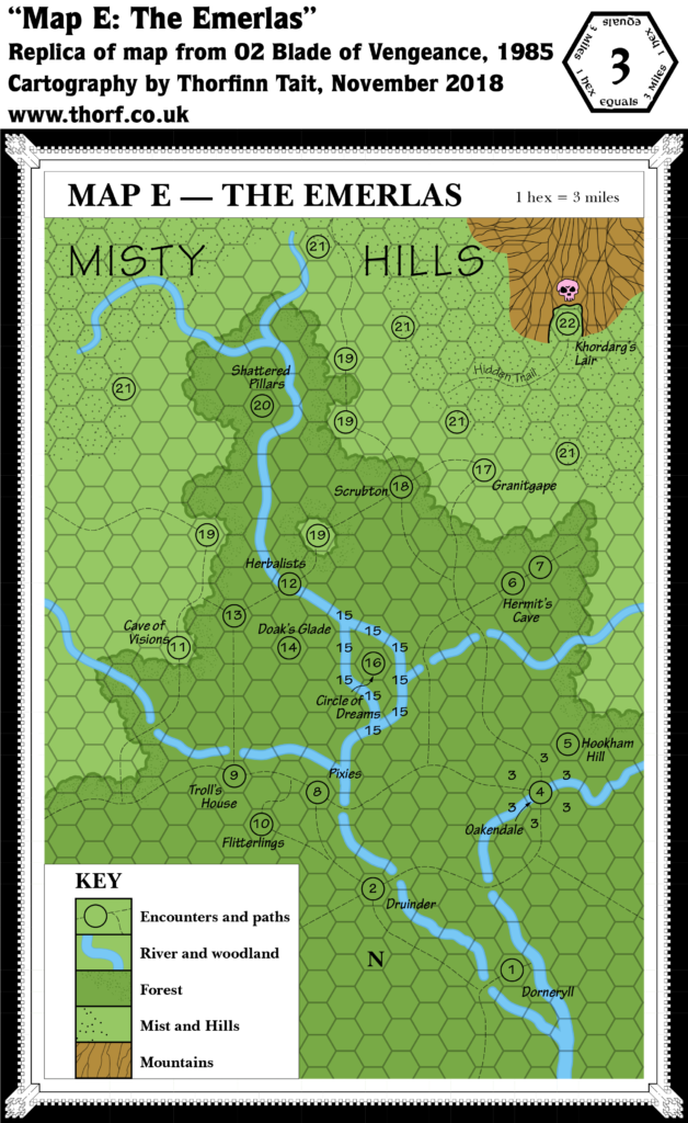
Replica Map (November 2018)
Sources
- O2 Blade of Vengeance (1985) (PDF at DriveThruRPG)
- “Map E — The Emerlas”, cover gatefold (Cartography by Paul Ruiz)
Chronological Analysis
This is Map 30. It was published in February 1985. The updated version of this map has not yet been released. See also Appendix C for annual chronological snapshots of the area. For the full context of this map in Mystara’s publication history, see Let’s Map Mystara 1985.
The following lists are from the Let’s Map Mystara project. Additions are new features, introduced in this map. Revisions are changes to previously-introduced features. Hex Art & Fonts track design elements. Finally, Textual Additions are potential features found in the related text. In most cases, the Atlas adopts these textual additions into updated and chronological maps.
Additions
- Islands — none, although there is an area of land surrounded on all sides by a river.
- Mountains — a single mountain or mountainous area in the northeast, unnamed.
- Nations — no nations or borders are marked.
- Rivers — a major river system runs through the area, unnamed on the map.
- Settlements — Dorneryll, Granitgape, Oakendale and Scrubton.
- Terrain — the Emerlas, apparently the name of this area of forest — which is presumably part of the Canolbarth Forest marked in previous maps. North of the forest’s limits, across a few miles of plains, are the Misty Hills.
- Trails & Roads — an extensive network of paths thread through the area.
Hex Art & Fonts
- Fonts — hand-written text throughout.
- New Symbols — the map is hand drawn, mostly using area patterns instead of symbols. Forest is a green-coloured cloud-shape. “Mist and Hills” is a paler green with a dot pattern. Mountains are grey with ridge-lines marked. The only symbol is a pink skull for the dragon’s lair. The compass is like an arrow made from bamboo.
Textual Additions (O2 1985)
- Government — the area as a whole does not seem to have had any central government, even before Khordarg’s devastation.
- Military — the main force in the area is the red dragon Khordarg and her army of humanoids. Each settlement has its own militia, but most of these have already been destroyed before the start of the adventure; the only surviving town is Oakendale, with a 10-strong halfling militia (p. 12).
- Nations — nominally part of Alfheim (referenced on p. 2-3).
- Placement — “The northern tip of Canolbarth Forest (Map 2 Expert Rulebook – page 33) is a wild and beautiful area known as the Emerlas.” (p. 2)
- Races — interestingly, there are human, dwarven, and halfling communities in the Emerlas region. It’s unclear if these are part of Alfheim or on the border.
- Settlements — the adventure introduces four settlements, but most of these are in ruins even as the adventure begins. Dorneryll was an elven village (p. 2, 4-7), population 17 (p. 5) before its ruin. 8 “distant kin from Alfheim” return with the hero at the end of the adventure, with the intent of restoring the village (p. 26), so the post-adventure population is presumably 9 elves. Granitgape was a dwarven stronghold (p. 2, 18-19), population unknown. It remains a ruin. Oakendale is the only surviving settlement (p. 12-13), although it may well be destroyed during the course of O2’s action (p. 10-11). It is a halfling village, population 46 (p. 12). Scrubton was a human village, population unknown. It was burnt to the ground by Khordarg. (p. 19)
Join in the Discussion at The Piazza
Come and join in the discussion about this map at The Piazza, where I am holding a “read through” of the Let’s Map Mystara project.

27 March 2019 @ 1:33 am
Hi Thorf
Great Replica
You say “The terrain outside the Canolbarth doesn’t really match up with that shown on X1’s Known World map, unfortunately. Nor does it merge easily with later developments of Alfheim, which seem to have overlooked O2’s details.”
I have been succesful in merging this map in my 1 mile hex map of the Canolbarth http://pandius.com/m_cbrth1.html as best as possible while following canon dominantly
Hope it helps if you need it.
Greets
Robin