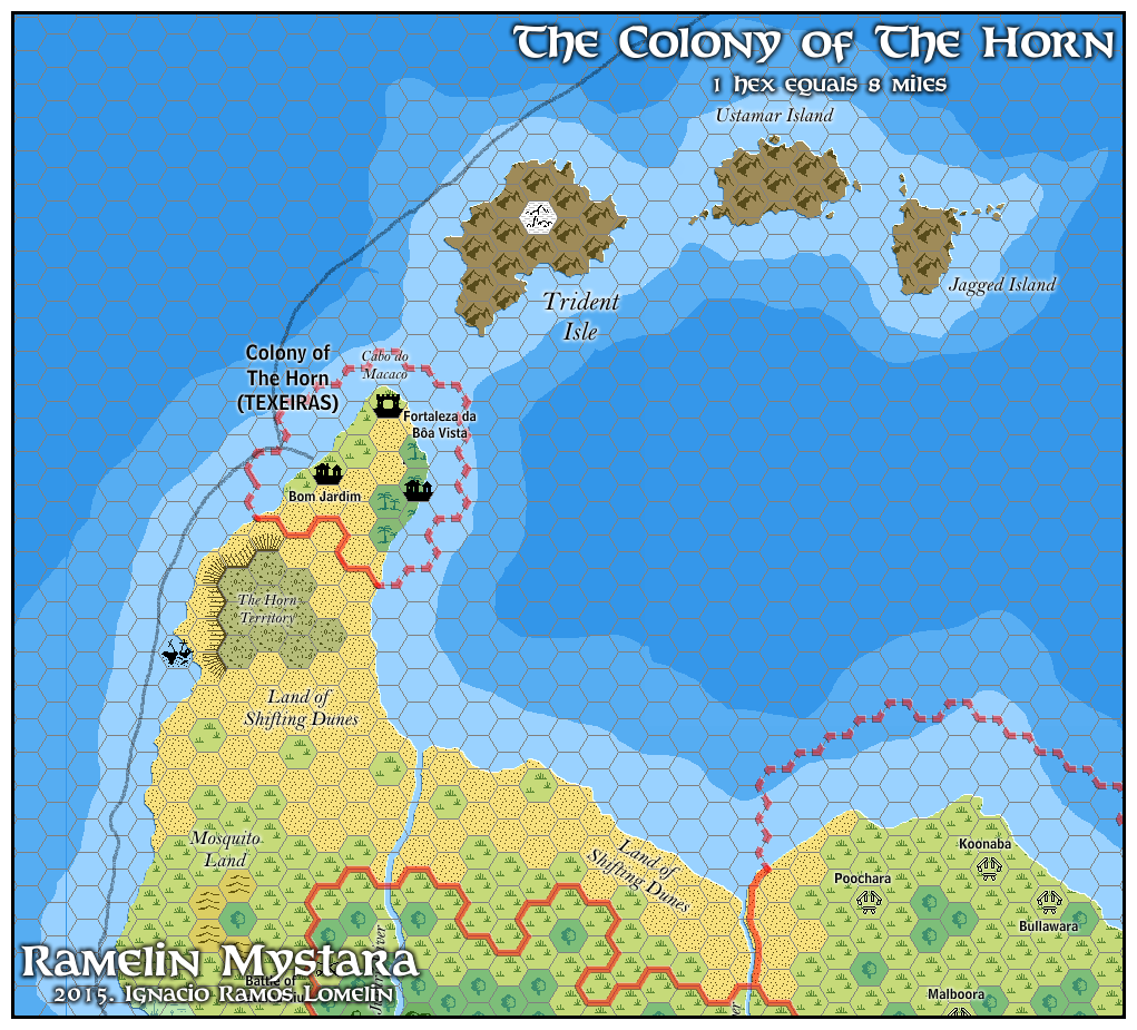
Ramelin’s Colony of the Horn, 8 miles per hex
Jose may have been the first Mystaran cartographer to give his full attention to the Colony of the Horn, a tiny Texeiras dominion on the back end of the Orc’s Head Peninsula. Of course he wasn’t the first to map it, but he was certainly the first to give it a map of its own; originally it was a small side-detail on Dragon #188’s Jibarú map.
He had already finished a map of Southold two months prior, and this little map is almost identical. However, it includes two innovations: it was the first map to name Trident Isle, the largest of the Trident Isles; and he added the shipping lane.
Fan-made Map by Jose Ignacio Ramos Lomelin (February 2016)
This is an original map created by one of Mystara’s excellent fan cartographers. For more information on the cartographer, including a gallery of all their maps, see also Appendix M: Mappers of Mystara.
Sources
- The Voyage of the Princess Ark Part 33: Lords of shade and hue, Dragon #186 (October 1992)
- The Voyage of the Princess Ark Part 35: The return home, Dragon #188 (December 1992)
- Red Steel (1994) (PDF at DriveThruRPG)
- Trident Bay Region
Fan Sources
- None
References
- All of Jose’s maps at the Atlas of Mystara
- Jose’s entry in Appendix M: Mappers of Mystara (upcoming)
- Jose’s author page at the Vaults of Pandius
Chronological Analysis
This is a fan-made map. It was published in February 2016. The updated Atlas version of this map is not yet available. See also Appendix C for annual chronological snapshots of the area. For the full context of this map in Mystara’s publication history, see the upcoming Let’s Map Mystara 2016.
The following lists are from the Let’s Map Mystara project. Additions are new features, introduced in this map. Revisions are changes to previously-introduced features. Hex Art & Fonts track design elements. Finally, Textual Additions are potential features found in the related text. In most cases, the Atlas adopts these textual additions into updated and chronological maps.
Additions
- Islands — Although the Trident Isles themselves were not new, they lacked individual names. Jose added these: Trident Isle, Ustamar Island, and Jagged Island. The tiny islands dotted around the eastern Trident Isles are also Jose’s invention.
Revisions
- Coastline — As usual for his maps, Jose roughened the coastlines slightly.
- Sea Depths — Red Steel included two stages of deeper water around the coasts. Jose’s depths are similar to these overall, but they don’t match, especially in small details.
- Spelling — Jose made the following changes to spelling from the original maps. In all likelihood most of these were errors rather than deliberate choices; the Dragon maps were always a little hard to read, especially from the low resolution scans available online.
- Fortaleza da Boa Vista became Fortaleza da Bôa Vista.
- The Horn (Unclaimed Territories) became The Horn Territory.
- Land of the Shifting Dunes became Land of Shifting Dunes.
Hex Art & Fonts
- Hex Art — Ramelin Mystara standard.
- Fonts — Bell MT (major geographic and all water labels), Bell Centennial (all other labels), Feinen (titling).