X7 Sea of Dread, 24 miles per hex
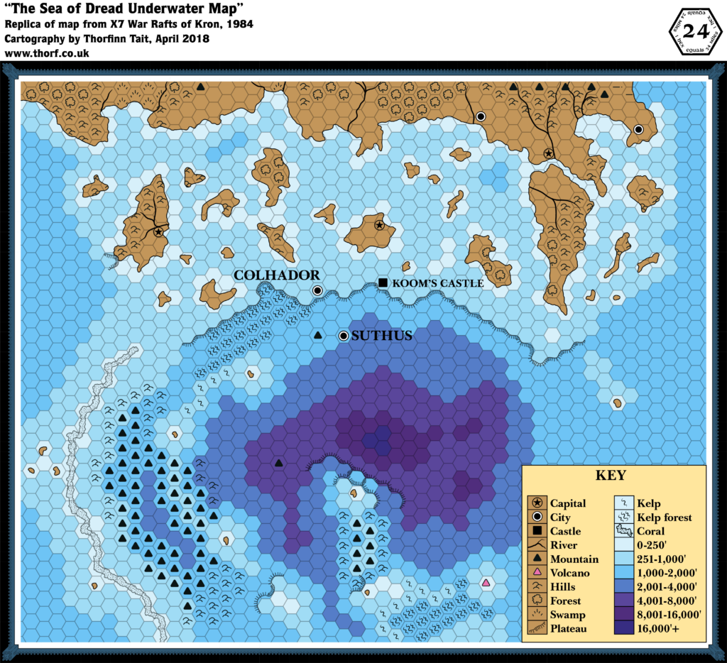
Not content with the massive land expansion of 1984 in previous modules from X4 to X6, X7 instead expanded into the ocean itself, providing a wonderful view of the land beneath the waves of the Sea of Dread.
Depths were not marked on maps again for another few years, and this map remains one of the two best sources for the undersea layout of the region, the other being 1990’s PC3.
Replica Map (April 2018)

Sources
- X7 The War Rafts of Kron (1984) (PDF at DriveThruRPG)
- “Sea of Dread Underwater Map”, cover gatefold (Cartography by David S LaForce)
Chronological Analysis
This is Map 24. It was published in September 1984. The updated version of this map has not yet been released. See also Appendix C for annual chronological snapshots of the area. For the full context of this map in Mystara’s publication history, see Let’s Map Mystara 1984.
The following lists are from the Let’s Map Mystara project. Additions are new features, introduced in this map. Revisions are changes to previously-introduced features. Hex Art & Fonts track design elements. Finally, Textual Additions are potential features found in the related text. In most cases, the Atlas adopts these textual additions into updated and chronological maps.
Additions
- Depths — contour lines and depths for much of the Sea of Dread, with precise numbers assigned to each depth line. This is the second map to give ocean depths (the first being X6), and the first for this area.
- Reefs — the Dragon’s Teeth Reefs detailed in XSOLO’s text appear here for the first time. How far the reefs extend south is not entirely clear from this map, though XSOLO’s text is a useful reference for this.
- Settlements — Colhador (city), Suthus (city), Koom’s Castle.
- Underwater Terrain — kelp and kelp forests as well as undersea mountains and hills. A single volcano is marked, though it’s not clear if this is underwater or a volcanic island above sea level. The depth around the mountain suggests that it is at least close to the surface, since the hex it’s in is 0-250′ deep.
Revisions
- Coastline — almost the same as previous maps of the area; it’s clearly traced from those maps.
- Islands — the islands here correspond to both X1’s as well as XSOLO’s islands, with the same general locations and shapes.
Hex Art & Fonts
- Fonts — Baskerville. Map title (not shown here) is Bernhard Modern.
- New Symbols — Kelp (a single diagonal squiggle), Kelp forest (three diagonal squiggles — like Kelp Jungle from Companion Set but mirrored), Coral (dotted texture within a solid black line). Underwater Mountain and Hills are also used here for the first time; the symbols are identical to overland versions.


Textual Additions (X7 1984)
- Government — there are some insights into the government of the Minrothad Guilds: “The isle of Minrothad is divided into many small baronies. The baronies form trading guilds, each having its own plot of land. The family-owned guilds have much vicious political dissension among them. The city of Minrothad is neutral territory where the guilds can meet and trade.” There are also hints of xenophobia: “The merchants of Minrothad will not sell magical items to foreigners.” (p. 4)
- Islands — “The guild’s masters offer you a small island (six square miles) next to Minrothad if you can rescue the princess and discover who is pirating their ships.” (p. 4) This island is far too small to appear on 24 mile per hex maps; most of the small islands of the Sea of Dread are around 60 square miles, so this isle would be a tenth of their size — a mere speck at this scale.
- Nations — official titles for the nations in X7 are: the “city-state of Suthus” and the “Grand Hydrate of Kron”. (p. 10)
- Races — Koom’s Castle is inhabited by a lone storm giant. Suthus is inhabited by tritons. Colhador is largely ruined, and essentially a dungeon now. Kron’s inhabitants are human.
- Rulers — Lopra is the triton king of Suthus. (p. 7) One-Eye is the pirate ruler of Kron. (p. 7) Hadric of Colhador, now a velya, was a prince of that ancient city before it sunk to the sea-floor. (p. 7, 26, 28) The ruler of ancient Colhador was King Hador, son of Gorlab. (p. 28)
- Settlements — there are four settlements, including the three marked on the map and the titular raft city:
- Koom’s Castle is the underwater home of the storm giant, Koom. It is located right at the edge of an underwater cliff. (p. 5-6)
- The raft city of Kron “floats upon the sea, its position is ever-changing”, according to Koom the storm giant. (p. 6) Koom further states that Kron is two days’ sailing south of Koom’s Castle, after which its exact position can be found by befriending dolphins, which can find the city. (p. 6) Kron is a city of pirates, whose existence is made possible by an artefact: the Horn of the Sea God (p. 4), a throne shaped “after the hand of a sea god”, which prevents anything attached to it from sinking. (p. 13) Population of Kron is unclear.
- The “sunken city” of Colhador (p. 6), like Koom’s Castle, is on the edge of the undersea cliff. It “was one populated by airbreathing people. A catastrophe many centuries ago caused it to sink to the ocean floor. Among the tritons there are rumours of other cities of the same people, now lying on the ocean floor.” (p. 19) So it seems that Colhador is just one of many ruins in this area, and in fact this area was land hundreds of years ago.
- Suthus, “city of the tritons” (p. 7) or “citadel of the tritons” (p. 6), is a “city made entirely from dead coral cut from distant reefs”. (p. 7) The population is unclear, though it seems to be wholly composed of tritons.
- Shipwreck — the text gives a shipwreck encounter to be discovered “at any point in the adventure”. (p. 6) Given this and the nature of the adventure (pirates sinking trading ships), it seems safe to assume that the Sea of Dread is littered with shipwrecks.
Analysis
The text of X7 doesn’t provide all that much that can be added to the map. I’d like to be able to place Kron, with arrows showing its approximate course. But there’s not really enough information to do this. For now, it has been placed seven hexes south of Koom’s Castle.
Join in the Discussion at The Piazza
Come and join in the discussion about this map at The Piazza, where I am holding a “read through” of the Let’s Map Mystara project.
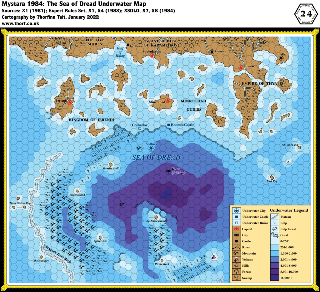
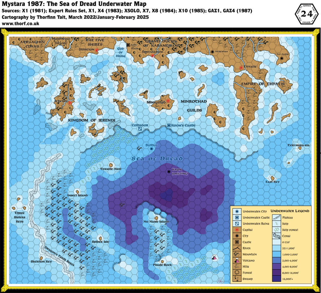
Past and Future Versions of this Map


