X9 Savage Coast
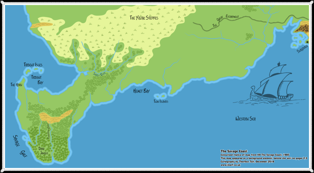
Ironically, the most complete map of the Savage Coast area included in 1985’s module X9 The Savage Coast was not so much a map as a background to the opening pages of the module. Despite the pages’ text obscuring much of the map, it nevertheless depicts the whole area, from Slagovich in the east to the tip of the Orc’s Head Peninsula in the southwest, from the Great Escarpment to what would later be named the Grass Coast of Yalu Bay.
As such, this map covers a larger area than the module’s accompanying hex map, but in an illustrated rather than hex style. Although it doesn’t have settlements or beaches marked, it otherwise includes all the same terrain as the hex map.
The real significance of the map, though, lies in clearing up the ambiguous join between the Savage Coast and the Gulf of Hule: working just with the hex maps, it’s impossible to see exactly how the authors intended the maps to be joined up, but this map explicitly shows their intent.
Replica Map (December 2018)
Sources
- X9 The Savage Coast (1985) (PDF at DriveThruRPG)
- Pages 2-3; map is the background to the text (Cartography by Dave “Diesel” LaForce)
Chronological Analysis
This is Map 38. It was published in 1985. The updated version of this map has not yet been released. See also Appendix C for annual chronological snapshots of the area. For the full context of this map in Mystara’s publication history, see Let’s Map Mystara 1985.
The following lists are from the Let’s Map Mystara project. Additions are new features, introduced in this map. Revisions are changes to previously-introduced features. Hex Art & Fonts track design elements. Finally, Textual Additions are potential features found in the related text. In most cases, the Atlas adopts these textual additions into updated and chronological maps.
Additions
- Coastline — The major contribution of this map is that it makes the join between X9 and X5’s hex maps explicit. The continental map could also be used for this purpose, but since it only included coastlines and a few rivers, this map serves the purpose far better.
- Terrain — As well as reprising most of the hex map’s terrain (minus beaches), this map adds grasslands to the Yazak Steppes (which were plains on X9’s hex map), and of course extends them northwards. The eastern extent is a little different from the part that appeared on X5’s map, but it’s easy to merge these. Finally, there’s a small line of hills in the far west.
Revisions
- Coastline — This map includes all the coasts shown on X9’s hex map, expanding northwest and east. None of this is really new, as it has previously appeared on CM1’s continental map and X5’s hex map. The match is quite good.
- Plateaus — The Great Escarpment appears on this map, but in a slightly different location from X5’s escarpment. The shape is very similar, and the eastern end matches quite well, but as it moves west it skews further north than X5’s.
- Rivers — The rivers mostly line up well with the hex map’s rivers; although their courses are often slightly different, it’s not enough to be significant — and some rivers are less detailed on this map. The northeastern river system largely lines up with X5’s rivers, too. The New Hope River and its tributaries are strangely absent.
Hex Art & Fonts
- Fonts — Hand-written text throughout; matches the text on the hex map.
- New Symbols — Hand-drawn, symbolic style. Forests and jungles are represented by tree-like symbols, while grasslands use the usual grass patch but without hexes. Note that the black and white original map did not show background colours for any of the terrain, so the grassland yellow and the light brown of the hills are my own addition.
Join in the Discussion at The Piazza
Come and join in the discussion about this map at The Piazza, where I am holding a “read through” of the Let’s Map Mystara project.

30 March 2019 @ 9:59 pm
Hi Thorf
Nice work.as always
Question; did I see it wrong, or is the peninsula of the dark jungle wider than the later editions, I could be wrong, yet I am not sure…it feels/seems though.
And in this map you clearly see the Dragon shape the artist intended I heard.
Why he did this I don’t know, yet in a dragon magazine he said the shape was intended to be that of a large dragon head and neck in a 90 degree angle.
Greets Robin
ps have you read my mail to you?
1 April 2019 @ 9:49 am
Hi Robin! Thanks for your comments as always. 🙂
As far as I know, the peninsula’s width remains pretty constant. It’s my impression that all successive maps were based on this one. But it’s been a while since I worked on this area, so I may have forgotten about something. Either way, I will continue to explore and compare this in Let’s Map Mystara.
Your comment about the dragon shape is very interesting. Do you happen to know which Dragon magazine that comment appears in? I tried searching, but this is not at all an easy thing to find. I’d love to see the original article. So it was supposed to be a dragon’s head rather than an orc’s?
And thanks, I’ll check my e-mail now.