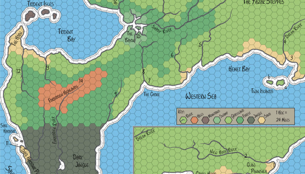
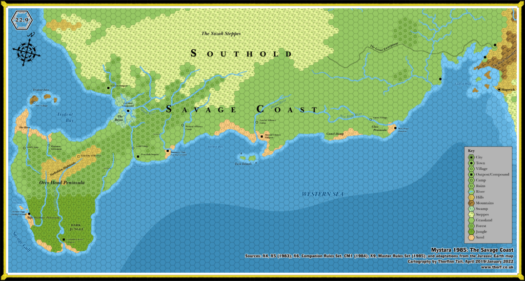
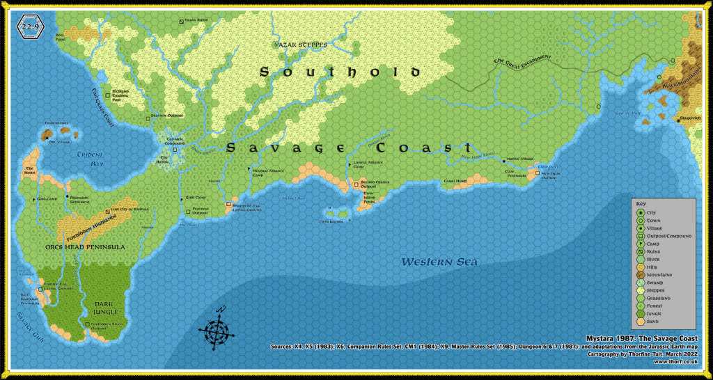
X9 Savage Coast, 24 miles per hex
In 1985, X9 expanded the map to the far west, adding the Savage Coast region on to the previous year’s X5 Hule map.
Unfortunately, the join with X5’s map is not at all clear, and in fact highly problematic. It’s perhaps not surprising that this resulted in a legacy of misalignments and inconsistency with this area of the map.
The whole area was redesigned in greater detail in The Voyage of the Princess Ark series in Dragon Magazine, and later consolidated in the Red Steel and Savage Coast campaign sourcebooks.
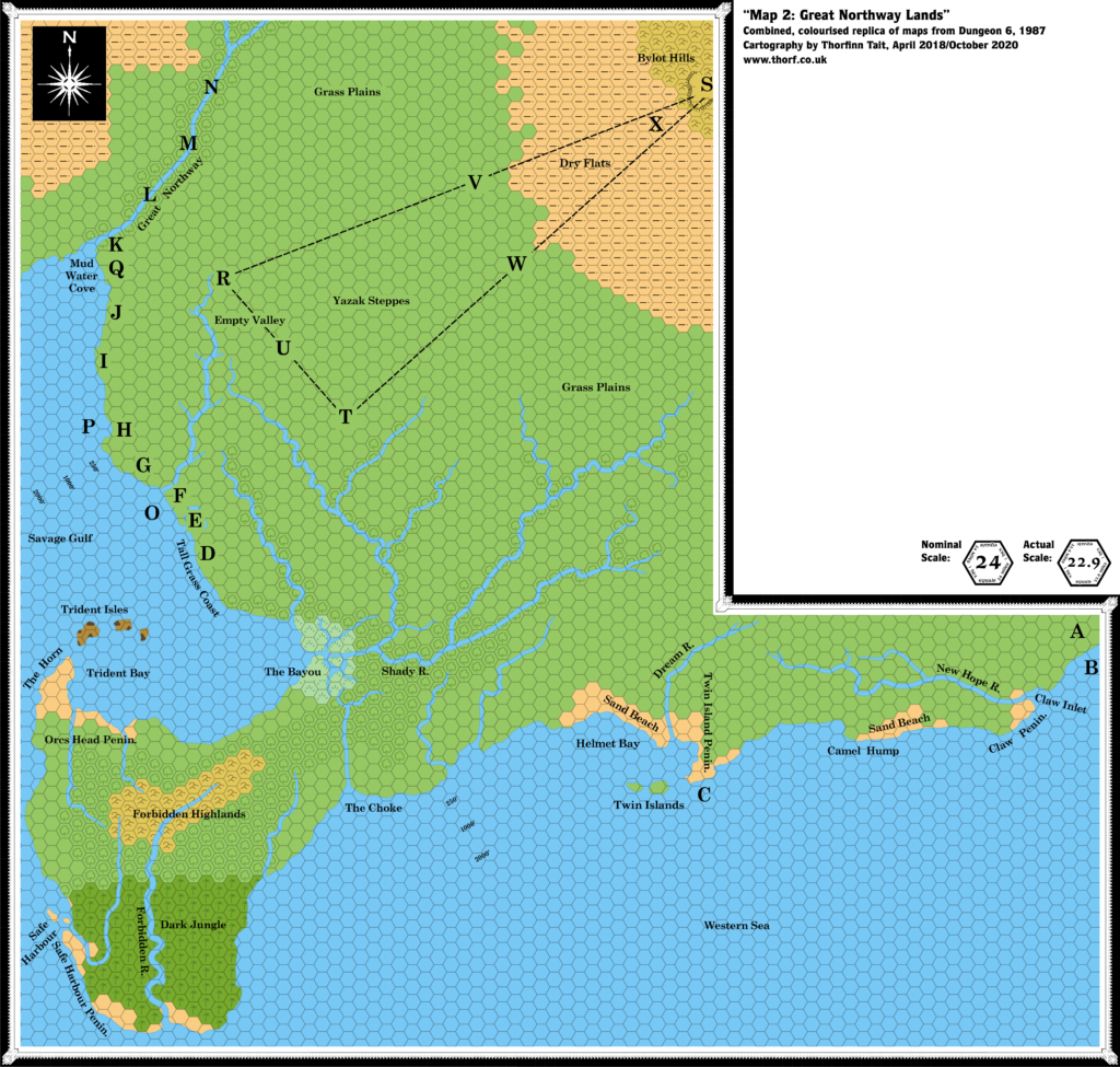
Note: though labelled 24 miles per hex, this map was actually 22.9 miles per hex. For a redrawn 24 mile per hex version, see Savage Coast, 24 miles per hex (1985).
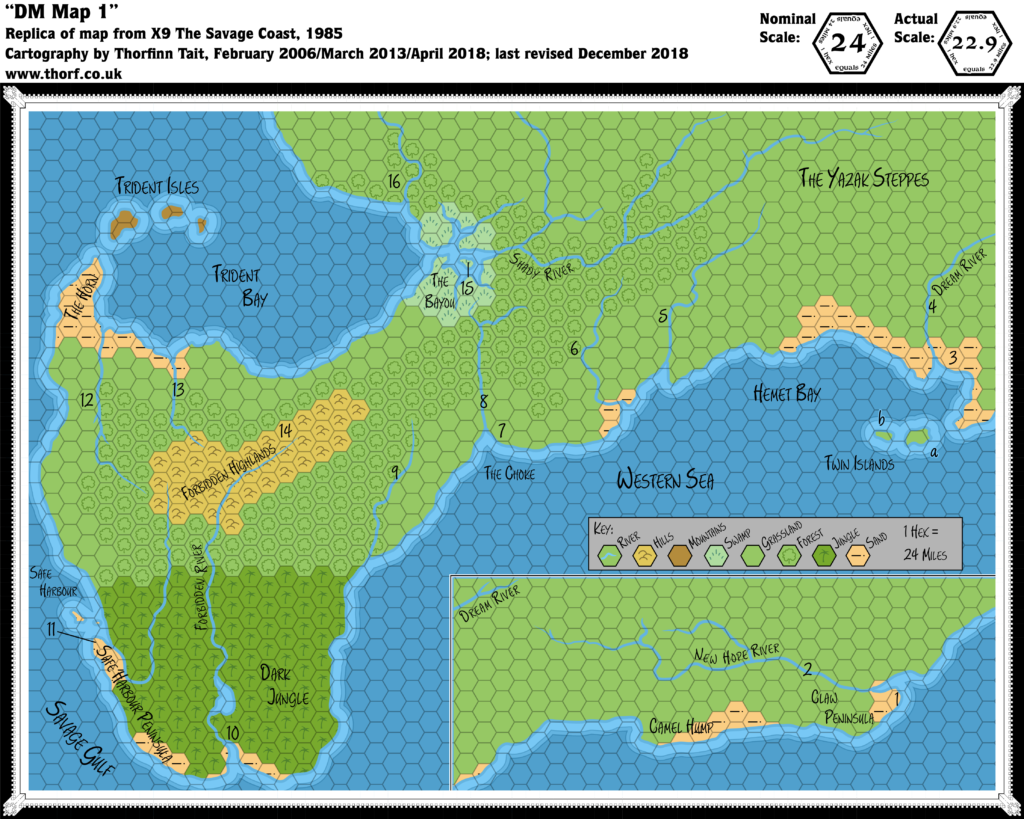
Replica Map (December 2018)
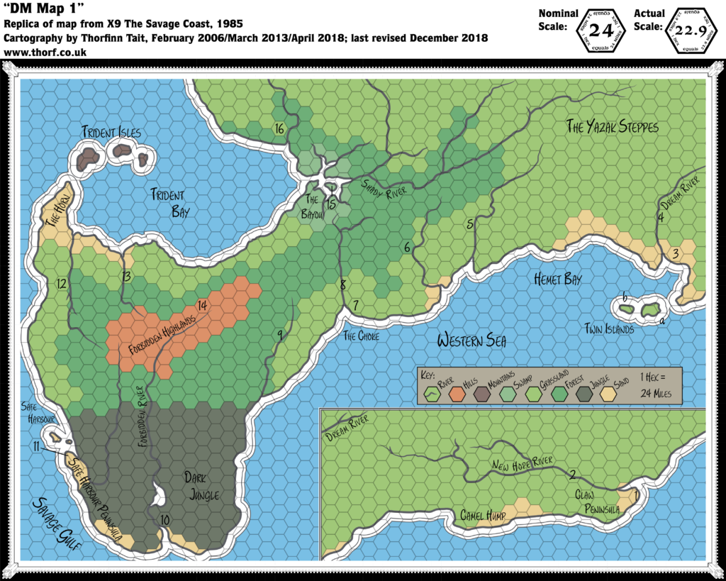
Replica Map with Original Palette (December 2018)
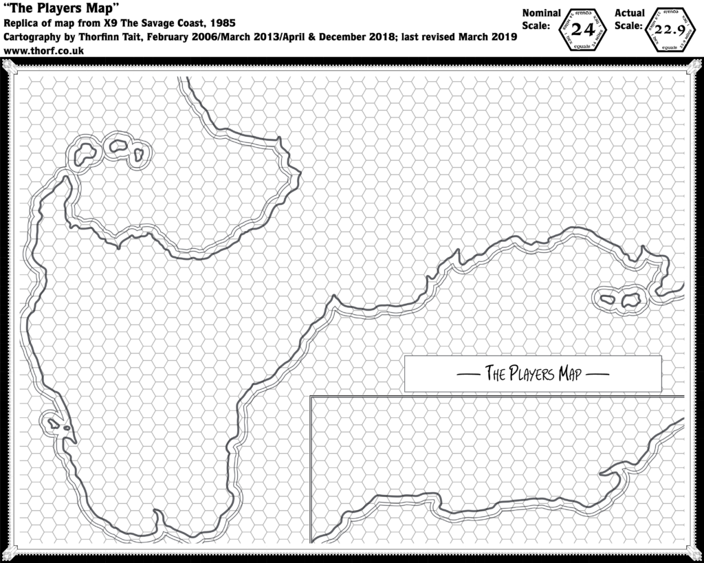
Replica Map (March 2019)
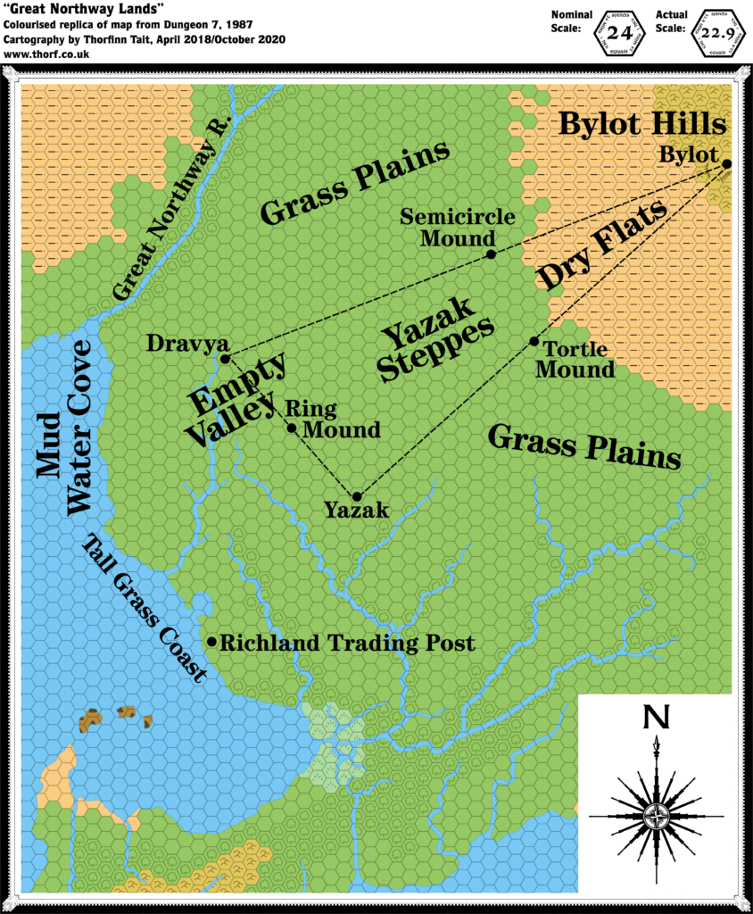
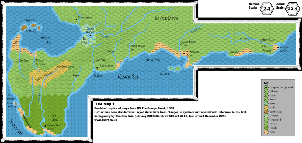
Combined Replica Map (December 2018)
Sources
- X9 The Savage Coast (1985) (PDF at DriveThruRPG)
- “DM Map 1”, cover gatefold (Cartography by Dave “Diesel” LaForce)
Chronological Analysis
This is Map 37. It was published in October 1985. The updated version of this map has not yet been released. See also Appendix C for annual chronological snapshots of the area. For the full context of this map in Mystara’s publication history, see Let’s Map Mystara 1985.
The following lists are from the Let’s Map Mystara project. Additions are new features, introduced in this map. Revisions are changes to previously-introduced features. Hex Art & Fonts track design elements. Finally, Textual Additions are potential features found in the related text. In most cases, the Atlas adopts these textual additions into updated and chronological maps.
Additions
- Coastline — From the Gulf of Hule in the east to what will later be called the Grass Coast on Yalu Bay in the west, the whole coastline here appears at this scale for the first time.
- Islands — While most of them appeared previously on the continental map, the Twin Islands, Trident Isles, and the tiny islands of Safe Harbour appear here in detail for the first time.
- Lakes — A small lake in the Dark Jungle.
- Rivers — Four major rivers are named: the Forbidden River, New Hope River, Dream River, and Shady River. All of these have unnamed tributaries, and there are eight other unnamed minor rivers.
- Seas — Helmet Bay and The Choke are bays on the Western Sea. The Savage Gulf is the name of the strait in the far west, although the Arm of God is just off the edge of the map, and doesn’t appear in X9 at all. Safe Harbour is a small bay on the Savage Gulf. Further north, we have Trident Bay.
- Settlements — None marked. See Textual Additions below for details of the numbers marked on the map.
- Spelling — “Hemet Bay” seems like an obvious spelling error, and is most likely supposed to be “Helmet Bay“.
- Terrain — The Yazak Steppes, previously featured in the corner of X5’s map, are expanded here all across the north of the Savage Coast. They were previously marked as grasslands, but here the hex symbols for plains and grasslands have been merged into one symbol, making it hard to see their exact extents. The Claw Peninsula is located at the southwestern edge of the Gulf of Hule (though that name doesn’t appear on this map). Camel Hump is a sandy bump on the coastline to the west of this. The large peninsula to the west (unnamed on the map) includes the Dark Jungle, Safe Harbour Peninsula, the central Forbidden Highlands, surrounded by forests, and The Horn pointing out towards the Trident Isles. Finally, The Bayou is a large swampy region on Trident Bay.
Hex Art & Fonts
- Fonts — Hand-written text throughout.
- New Symbols — None, though the hex “art” is not so much art as coloured hexes.
Textual Additions (X9 1985)
- Climate — “The general weather patterns move from west to east. There is often a wind from the north, east, and south. The coastal climate of this area is similar to the southeast United States. Inland, the climate is similar to that of the Mediterranean. The mild weather continues even during the winter. Thunderstorms in the Dark Jungle and gentle showers over the rest of the area occur year round.” (p. 2)
- Factions — The adventure introduces a number of competing factions: the Brotherhood of Light (p. 3); their rivals the Lawful Brotherhood (p. 3); and the Neutral Alliance (p. 8). The Lawful Brotherhood is said to have established outposts, and to be interfering with natives and adventurers in the region. (p. 3)
- Fauna — A group of tyrannosaurus rex live on the Twin Islands. (p. 7)
- Placement — The module states that “the eastern edge of DM Map 1 connects with the western edge of the Map of Hule on page 31 of adventure X5, The Temple of Death.” (p. 2) This is vague and rather unhelpful. In fact, the northern edge of the inset part of the map connects with the southern edge of X5’s map — and due to the rotation, it doesn’t even fit very well. Nor is it easy to see how it should fit together without reference to the continental map. (See Analysis below for more on placement.)
- Races — There are mermen living in the coastal waters east of the Claw Peninsula in the Gulf of Hule (p. 4), and near the Twin Islands (p. 6-7). 6 and 9 on the map indicate Aranea lairs (p. 8, 11). Tortles can be found wandering along most of the beaches of the Savage Coast, including at Claw Peninsula, Camel Hump, Twin Island Peninsula, and along Helmet Bay (p. 6, 8).
- Seas — Claw Inlet is the name of the bay north of the Claw Peninsula, on which the New Hope Outpost sits. (p. 6) Helmet Bay‘s spelling on the map (“Hemet”) is confirmed to be a typo (p. 8 etc.).
- Settlements — The adventure begins in Slagovich, in the Hogs Head Inn. The Cartographers Guild of Slagovich is also mentioned. (All p. 3) The Savage Coast is “dotted with primitive tribes, each with its own taboos and traditions” (p. 3). The map key details numerous settlements: at 1 stands the New Hope Outpost, on the sandy point of the Claw Peninsula (p. 4); 2 is a native village, population 100 (p. 5-6); 3 is the Second Chance Outpost, which is said to sit “at the mouth of a river” (p. 6, 7); 4 is a Lawful Alliance Camp, population about 50 lupins (p. 8); 5 is a Neutral Alliance Camp, population about 40 humans and about 25 rakasta (p. 8); 7 is (a?) Peaceful Outpost (p. 9-11; it’s not clear if this is a name or a description); 8 and 12 are Gold Camps (p. 11, 21); 10 is Forbidden River Outpost (p. 12); 12 indicates the Tortles’ Egg-laying Ground (p. 12); 13 is a Phanaton Settlement (p. 21); 12 is the Lost City of Risilvar (p. 21-24); 15 is a Cay-men Compound (p. 24-25); and 16 is the Seaview Outpost (p. 25). There is an Orc Village on one of the Trident Isles (p. 12, 21). There is a fortified Snappers’ Egg-laying Ground at the beach in the west of Helmet Bay, population 20 snappers (p. 9).
- Terrain — The large peninsula in the west is known as the Orcs Head Peninsula. (p. 2, etc.) Interestingly, the first entry keyed in the relevant section of the text is 5, Neutral Alliance Camp (p. 8), suggesting that the peninsula is considered to begin around this area; I had always considered the peninsula to begin at the thinnest neck of land near The Choke.
Analysis
Lining up X9’s maps with the continental map and the other hex maps is far from simple. There are two outstanding issues: rotation and scale.
Dealing with the rotation first, we know from the Master Set map that all of Brun’s maps are rotated 2.68º anticlockwise in relation to the world map. Interestingly enough, it turns out that X9’s non-hex map (map 38) has no rotation. In other words, it aligns perfectly with the world map; to fit it together with Brun’s continental map, we have to rotate it 2.68º anticlockwise.
But X9’s hex map is very different from this. In fact, it requires an additional 2º anticlockwise rotation in order to fit, making it 4.68º anticlockwise in relation to the world map, and 2º from the continental map and other hex maps. Looking at the map, this was most likely done in order to fit everything on a single page — it’s a very tight fit, after all.
So in short this means that X9’s hex grid will not line up perfectly with the adjacent X5 Gulf of Hule, as it’s already out of rotation.
But the scale is also out: X9’s hex map is simply too big. This can be resolved by shrinking the map, and I’ve found that a scale of 22.9 miles per hex makes for a very snug fit. Unfortunately, this will have a knock-on effect on all successive maps of the area, as everything that comes after is based on this map.
Join in the Discussion at The Piazza
Come and join in the discussion about this map at The Piazza, where I am holding a “read through” of the Let’s Map Mystara project.

