
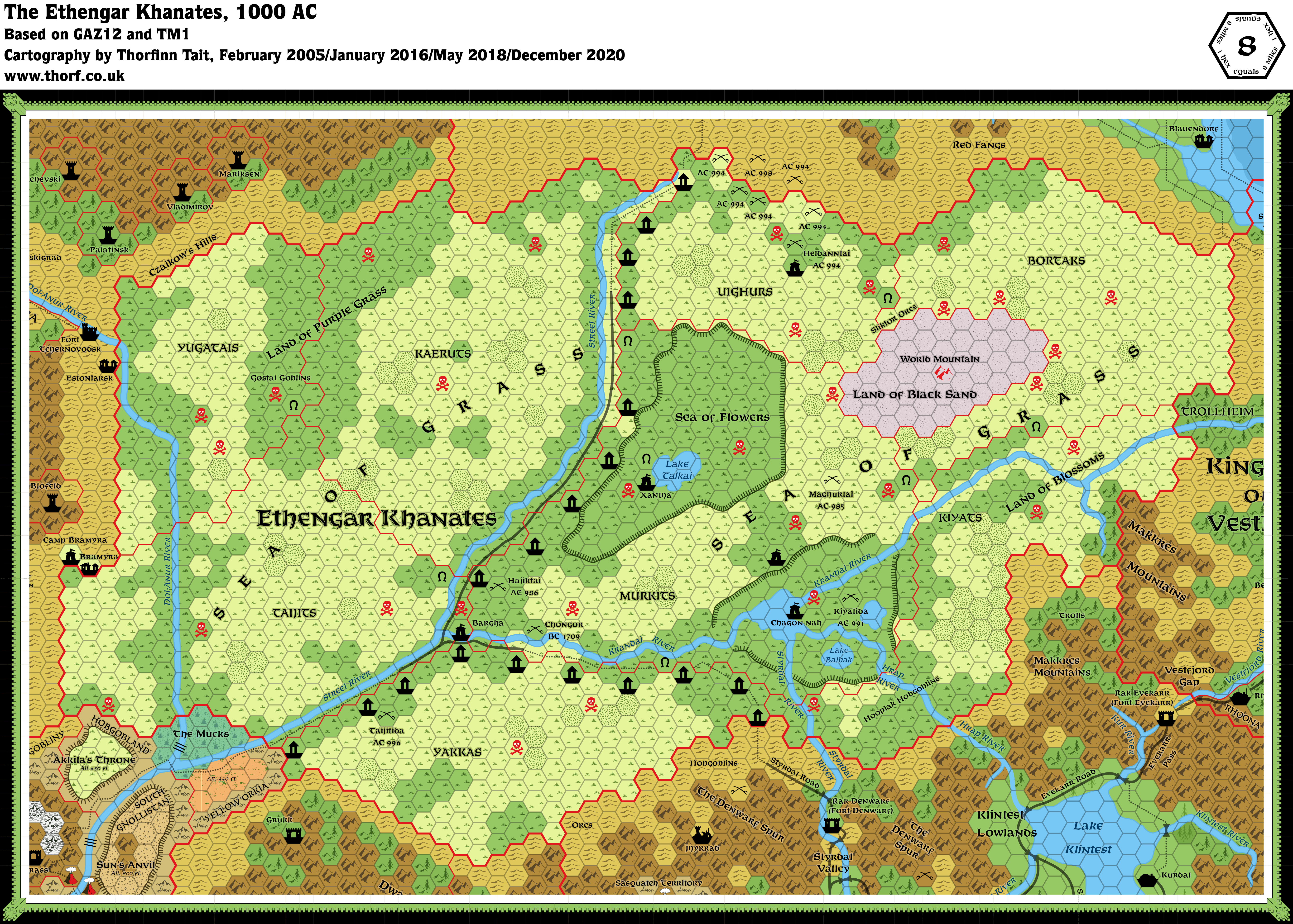
Ethengar, 8 miles per hex
Ethengar is a vast grassy plain, offering little protection from either the bitter winds of winter or the blistering sun of summer. This rough land tests the people who live on it every day, and those who survive that test grow strong and hardy. It is a land of warrior horsemen, as fierce and deadly as they are skilled.
from GAZ12 The Golden Khan of Ethengar, by Jim Bambra
Map (December 2020)
Sources
- GAZ12 The Golden Khan of Ethengar (1989) (PDF at DriveThruRPG)
- GAZ6 The Dwarves of Rockhome (1988) (PDF at DriveThruRPG)
- TM1 The Western Countries (1989)
- TM2 The Eastern Countries (1989)
- Rules Cyclopedia (1991) (PDF at DriveThruRPG)
Comments
The Ethengar steppes make for a rather boring hex map, due to the lack of variation. To solve this problem, the designers created two variants of the grassland hex: poor and choice grazing land. They also added in various depressions, along with rivers and small lakes. Then there’s the Land of Black Sand. Other than that, the land is largely a featureless plain; the nomadic nature of the Khanates means very few permanent settlements can be shown, resulting in a country with but three or four camps and no cities, towns or villages at all. It’s quite unique in the Known World.
Another problem is the elevations of the terrain. The text states it to be a plateau, above much of the surrounding terrain. However, Rockhome’s rivers flow downhill into the steppes, and there is no barrier marked between the steppes and the nearby coast.
But by far the biggest criticism of the steppes is their size: they have repeatedly been said to be far too small for the horsemen’s culture.
Notes
- Altitude – “The steppes are on a plateau that rises high above the surrounding lands. Mountains border this plateau, except to the east and part of the north.” “The steppes are 3,800 feet high in the west, gradually rising to 4,000 feet in the east and south.” (GAZ12 DM’s Guide page 6a)
- Bargha – the site of the Golden Khan’s winter court. (GAZ12 DM’s Guide page 7b, 15a, 19a-b)
- Battle, 919 AC – “919 AC: Ethengar Horde under Toktai Khan attacks Hayavik in the Heldann Freeholds. The attack is repulsed and the Horde returns to the steppes.” (GAZ12 DM’s Guide page 5c)
- Battle, 926 AC – “926 AC: Toktai Khan besieges Hayavik and is killed in the final battle. Hayavik destroyed.” (GAZ12 DM’s Guide page 5c)
- Battle of Chongor, 1709 BC – “Akkila-Khan joins with the Ethengars and defeats King Loark at the battle of Chongor.” (GAZ12 DM’s Guide page 5b)
- Battle of Skullhorn Pass – “645 AC: A Great Khan attempts a major invasion of Glantri but is defeated at Skullhorn Pass.” (GAZ12 DM’s Guide page 5c) This battle could be marked on the map.
- Chagon-Nah – “Around the junction of the Hrap and Krandai river, the land is wet and waterlogged, with large expanses of water lying between the confluence of the two rivers. In spring, large lakes from here form here from the meltwaters cascading down from the Makkres Mountains. As spring gives way to summer, the lakes begin to dry up, leaving many small islands surrounded by small lakes and ponds. Great numbers of trees and bushes grow here in the fertile soil …” (GAZ12 DM’s Guide page 7a) The lakes of Chagon-Nah are therefore largely seasonal. This has not been marked on the map. Chagon-Nah is the site of the Golden Khan’s summer court. (GAZ12 DM’s Guide page 7a, 15a, 19a-b)
- Heldanntai battles, 994 AC – “994 AC: Uighurs seek Moglai Khan’s aid against settlers from the Heldann Freeholds. The settlers are slaughtered.” (GAZ12 DM’s Guide page 5c)
- Krandai River bridge – “A wide wooden bridge has recently replaced the ferry that used to cross the Krandai River below Bargha.” (GAZ12 DM’s Guide page 8c) This bridge is obscured by the hex icon for Bargha, and therefore has not been marked on the map.
- Lake Talkai – “Lake Talkai forms in the spring months from water flowing into the Sea of Flowers … In summer the grasses, although protected from the scorching winds, are subject to high temperatures … Lake Talkai dries up and fine grasses grow on its damp bed.” (GAZ12 DM’s Guide page 6c) So Lake Talkai is a seasonal lake. This has not been marked on the map.
- Land of Black Sand – formed in 1700 BC as a direct result of the explosion caused by elves in the Broken Lands. “In this strange place, permanent gates opened between the Spirit World, the Known World, and the Sphere of Entropy.” (GAZ12 DM’s Guide page 5c) “This blighted area is covered in thick black sand and boulders. … the Land of Black Sand contains a gate to the Spirit World. This lies at the top of the World Mountain…” (GAZ12 DM’s Guide page 7c)
- Land of Blossoms – “Here cherry trees burst into bloom in early summer turning the banks of the river [Krandai] pink.” (GAZ12 DM’s Guide page 7b)
- Land of Purple Grass – “The Land of Purple Grass lies in a depression in the northwest part of the steppes. It is covered with thick purple grasses that thrive all year round.” (GAZ12 DM’s Guide page 7a)
- Maghurtai, 985 AC – “985 AC: The united Murkits defeat the warring clans of the Maghurs. All Maghur males are put to the sword.” (GAZ12 DM’s Guide page 5c) GAZ12’s poster map has this battle marked as taking place in 986 AC, but this is likely a mistake. The updated map reflects the text’s 985 AC.
- Overland Trade Route – “The Overland Trade Route passes through the Ethengar Khanates to link Darokin with the Heldann Freeholds, Rockhome, the Northern Reaches, and beyond.” (GAZ12 DM’s Guide page 8b) This refers to the roads and trails on GAZ12’s map, although there is no trail marked leading to Vestland. The roads are said to be under construction – the work of Rockhome dwarves employed by the Golden Khan.
- Rivers (Dol-Anur, Hrap, Krandai, Streel, Styrdal) – “The rivers of the steppes are shallow, broad, and slow flowing. They flow from the surrounding mountains and hills and frequently burst their banks in spring as the meltwaters run off the peaks. The rivers follow the downward tilt of the land tp the west to join the Streel River before turning south to flow into the Broken Lands.” (GAZ12 DM’s Guide page 8a)
- Sea of Flowers – “In the middle of the Sea of Grass lies the Sea of Flowers. Here the steppes enter a sheltered depression protected from the worst ravages of the winds. The Sea of Flowers is the most fertile part of the steppes as this area is well irrigated by water flowing from the higher land surrounding it. In spring, this region is covered with the many colourful flowers that give it its name. … In summer the grasses, although protected from the scorching winds, are subject to high temperatures that turn the Sea of Flowers into a land of yellow grass.” (GAZ12 DM’s Guide page 6c)
- Sea of Grass – “The Ethengars call their land the Sea of Grass. A vast expanse of flat grasslands dotted with the occasional clump of trees and rocky terrain, the Sea of Grass is far from being rich and lush. In some areas the grasses grow only in small patches, sufficient to feed a herd for a day before being exhausted. Along the banks of the rivers, the grass grows thicker and is capable of feeding a herd a week or more before a clan needs to move on.” (GAZ12 DM’s Guide page 6c) Although GAZ12’s map places the Sea of Grass label in a small area of the territory of the Kaeruts west of the Streel, it seems clear that this label can be applied to the whole area of the Khanates. Therefore the label has been enlarged and placed on both sides of the Streel, covering the whole territory.
- The Steppes – “Today the steppes are not fertile enough to support crops or large herds. In some places they are little more than arid wildernesses of gravel, sand, and rock, constantly lashed by winds from the surrounding mountains.” (GAZ12 DM’s Guide page 6a)
- World Mountain – “a vast towering edifice upon which the bodies of the Great Khans are laid to rest. Here a narrow bridge connects the World Mountain to the Spirit World.” (GAZ12 DM’s Guide page 7c)


15 November 2016 @ 9:35 pm
Nice work
I’ve been busy with the Streel/Krandai river in 1 mile for the secret of the Streel river in my Blog. So especially this is useful, with the extra compiled information.
Here my work thus far
http://6inchnails.deviantart.com/art/Streel-1-645977491
Though I see you also use the waterfall symbol in the Mucks… ;(
Not only is this impossible to have a waterfall in a stagnant swamp, but the earlier maps did not display that feature.
I think this was a flaw, or misplacement, as they also neglected some of the 3 waterfalls of the Vesubian in the Broken Lands.
17 November 2016 @ 2:06 pm
Robin, the three lines symbol is not a waterfall but rather rapids. The number of lines shows the danger of the rapids, or perhaps the speed? The label was “greater rapids”.
Having said that, I don’t know if that makes it any more realistic. It may be best to remember that the hexes don’t tell the whole story of the terrain, so if there are rapids there, perhaps the river goes through a rocky area within the swamp.
Even if it had been a waterfall, it’s still possible. Perhaps there is a cliff where the level of the land drops suddenly. Such things are hard to impossible to mark on a hex map, but it doesn’t mean they aren’t there.
Great work on your map, by the way. 🙂 I especially like the diagram at the bottom.
17 November 2016 @ 8:25 pm
three lines a greater Rapid?. while the same symbol is used elsewhere for waterfalls?
I remember two lines was rapid and three waterfall, although there was also one map atleast with a square symbol with a midline used in the same fashion and used as waterfall.
But don’t you agree with the fact that a muck/moor/swamp/bog or similar is slow flowing or standing water, thus with a near horizontal level?. As thus there are no altitude differences…that’s the basic principle biogeological to these areas.
And we have the differences in the maps of that region, there are several older versions NOT displaying anything on that location while later maps also reveal other flaws. Combining both this and the biogeological effect of swamps, isn’t it more logical to assume this is a flaw , continuously overlooked by later map makers?
I totally agree that hexes don’t tell the whole story, many details are lost. But cliffs, and such seem to be so impossible in a swamp…don’t you agree. There are as far as I know no real examples of swamps with either rapids, waterfalls or cliffs in any form. Water always flows the easiest way possible. I this cliff/rapid would be so, the only possibility is a sort of wall over the whole length of the area keeping water there, with only the rapid/waterfall as the place enabling further flow, though slow…that specific spot and wall than had to be reflected on the map in some way..
Not to critisize your awesome work, but I truly think this flaw is something not befitting to your great map.
In my research for the Broken Lands map in 1 mile hexes, I truly delved deep in this matter, and saw no other solution than that the rapid/fall is a flaw, an accidently moved symbol, which belonged to the three falls of the Vesubian River from the older maps.
http://breathofmystara.blogspot.nl/2016/10/1-mile-hex-map-eastern-half-of-broken.html
Here is my result of that area in 1 mile hexes.
To the rest; I agree there are many flaws made by the original mappers and I truly think, they forgot to see flow and altitudes in making the various maps. I had to solve this in the Streel…where a section flows Uphill magically. .
Thanx to my map, it is all research in an attempt to explain the flaws in Gazetteers and maps of this region.
Together with the 2300BC maps I could derive the Lake that was in this region and together with the fact that Ethengar rivers are very slow moving I devised the only logical flow pattern possible.
The Streel flows as normal (but with a magic effect in the Broken Lands against gravity…more about this soon in my http://breathofmystara.blogspot.nl ), and the Krandai flows from Bargha into the Sea of flowers and from the vestland region into the Sea of Flowers. evaporation and seeve like effects underground remove the season overflow.
Doesn’t this sound more logical /realistic?..in a world of magic? At least it explains the waterflow.
29 March 2017 @ 10:45 am
Robin — apologies for the very late reply.
I’m afraid you are misremembering the symbols for rapids and waterfalls. I checked the legend for GAZ10 (which is the same as the legend on the Trail Maps, which I have reproduced), and it lists four different symbols: three different line combinations for lesser, medium, and greater rapids; and the square with line through the middle for waterfalls. I have been unable to find a map that uses three lines for waterfalls.
My interpretation of this issue is that it’s a deliberate addition to the area. The Trail Maps saw quite a lot of additions throughout the map. Why should we interpret this one as an error while allowing the other additions to stand?
We have a basic disagreement here on how to interpret later maps. The policy of the Atlas has always been to give later maps priority, in almost all cases taking them as deliberate revisions to previous maps. I would agree that there are times when the original maps present something slightly better (the precise course of some rivers comes to mind), but usually the difference is quite minor.
In the case of the Broken Lands, the Trail Maps added three more Greater Rapids symbols, and changed one Lesser into Greater. It seems clear that the idea was to make the rivers a lot more treacherous than GAZ10’s map had portrayed them, to be more in keeping with the rough terrain of the region.
Perhaps it would be easier to interpret this as a flaw, but I am more inclined to take it at face value.
There’s one more thing to bear in mind here: these are not swamps/marshes, but rather moors/bogs. Despite the use of the same symbol, the terrain in question is very different. The exact definitions are rather complex and indeed quite wide, but my interpretation of moor/bog is a hilly area with peat covering most of the ground. It’s wet and quite treacherous, but quite different from swamp.
There’s no problem with having rivers flowing through a moor — indeed, they often have water run-off like this. And I believe a cataract should also prove no problem, as it only means an area where the river flows over/through/around large rocks.
Incidentally, if the Mucks are indeed an area of peat bog, the Streel River flowing out of them will very likely be a distinct brown colour.
Regarding rivers flowing uphill — I’ve heard these claims before, but I haven’t looked into the altitudes involved here. I see what you mean — the altitudes marked in the Broken Lands, particularly the low altitudes of the eastern areas, are quite problematic. I was going to suggest that there may be canyons and other erosion involved, but the figures are really quite extreme, and I don’t think this could explain them.
I see that you’ve made a great effort to explain these figures, but I think it might be better just to ignore them as a mistake. It looks as if perhaps the Red Orclands should be 1,350 feet rather than 350 feet, for example. At 350 feet, surely it would become a lake, filled by all the surrounding lands’ water run-off.
In any case, this is all theoretical for me, whereas you have actually tackled all of these issues and more in your wondrous 1 mile per hex map. Even if I don’t agree with all of your decisions, I still think you have created a great and definitive work. Bravo!
29 March 2017 @ 9:38 pm
No problem. A late reaction is still a rection ;P
I must agree with the symbols. You are right.
There is indeed a difference between the interpretation. The best map for the Broken lands deeming best was in my opinion the one from Gaz 10 orcs of Thar; here there are 3 sets of rapids on the Vesubian and none in the mucks. Gaz 11Darokin, Gaz12 Ethengar did the same in the Mucks.
The great difference came with Trail map 1, where there was only one rapid on the Vesubian and suddenly one within the mucks.
The older nondetailed gaz 3 and GkoM maps give both the Streel and the Vesubian 3 rapids, but lack any other detail.
Though the Vesubian rapids vary in number on these maps, their intensity seems to be all based on 3 line rapids.
The only actual flaw I see is the waterfall in the Mucks. any water surface will not have any rapid, waterfall within its midst.
Even if these are moors/bogs where water is lifted up due the vegetation, any height and flow will be on the edges, not the middle…that is basic geography/physics as was part of my study…I would be marvelled at finding a real world example where this is the case.
There is indeed no problem with a river flowing through a bog, but there are (ASAIK) no elevation variations other than a soft flow possible.
I totally agree to the brown or even darker color. Peat water lack oxigen an is in fact near “dead” water, however, any flow and the passage through sandy areas will revitalize the water.
As to the altitudes.
As according Broken Lands map, the area on the Ethengar side 350’, Bargdha according Trail map 1800’, as such the altitude of South western most of Ethengar I assume would be somewhere around 500-350′
This would mean that the area of Yellow Orkia and The Mucks are the lowest location 350′-280’(deemed logical as Fanon 2300BC maps explain this area was earlier a large lake, and there was NO waterway to the region of Corunglain, but instead one coming down from the area near the Twin Volcanoes, using the same path as the later Streel River path. Both Corunglain and Ethengar are at an altitude of 1800’ while the same river flows through the region. And worse of all it passes a mountain range known as the Broken Lands.
even if you would raise the areas to encompass a flow through the Broken Lands and down to Sea of Dread, this would alter Ethengar, Darokin and all waterflow extremely. The height of the river on the Ethengar side must be significantly higher than Corunglain’s 1800′ to enable a flow/current strong enough to pass the Broken Lands.
Thus far we have a flow from West 3800 to 350’ and Streel River 1800’ to 350’ the section between Bargdha and Northern Reaches must be significantly higher to give a flow strong enough to reach the Broken Lands.
As thus it can be surmised that the Krandai River, is actually NOT flowing towards the Broken Lands as the canon maps suggest. In fact starting in the Northern Reaches, it flows down a lower section of Ethengar. The map suggests it continues to flow West, but in fact this is NOT the case. From Bargdha the Streel River is split into a southwest Streel River and an east flowing Krandai River, which finally ends in the earlier lower depression of Ethengar. As thus the Krandai River is actually two rivers flowing in the same depression; one from Northern Reaches going west, the other going east from the west.
The reason that drained the former Anur/Grondheim Lake, flowed it against gravity over the Broken lands also enables the water to bypass the higher mountainous area between Ethengar and Corunglain. The only solution I could find (and agreed I need to finish that section on my Blog) is this section of river flowing magically uphill. and this is the Streel between the Mucks and the Twin Volcanoes.
I have made a sort of map in 3D of the flowcharts, and without changing most canon sources this was the only solution to a problem even Bruce Heard noticed decades ago.
I greatly accept your compliment to my 1 mile map. This means a lot to me, as a main cartographer of Mystara I greatly appreciate your input and your work in general. And even if we have our differences, where you see the maps and I walk (in my mind) in the area, we both will have our flaws and excellence. So I must thank you for the compliment, and can only give one well rewarded back. ;D
16 November 2016 @ 7:41 am
Great map, Thorf!
Had you thought or planned including sites such as Torkyn Falls, the abandoned gnome city, on the map? This would be from the Dragonlord book trilogy. They would be ruins, of course. But, they may just be underground, though (I’m not sure, I’d have to go to the books to check). (I looked for it but didn’t see anything like that on the map.)
17 November 2016 @ 2:08 pm
I’ve been on the fence about the Dragonlord trilogy for years now. Thus far, none of my maps incorporate anything from those novels, as far as I know.
I wouldn’t be opposed to adding it in if the community wants it, though.
17 November 2016 @ 2:22 pm
Right. Certainly a community consensus sort of thing, then. Well, I don’t see any clamoring for it.
I like to incorporate most (pretty much all, if possible) published works. But, I know there are conflicts. And, I am not as knowledgeable or well-versed as many others about lore, published works, etc.; so, I am not always qualified, or haven’t take the time to have done the research, to push against some consensuses (or lack thereof).
I love how to seek out input and feedback, and try to incorporate those things that a majority of the community supports!