
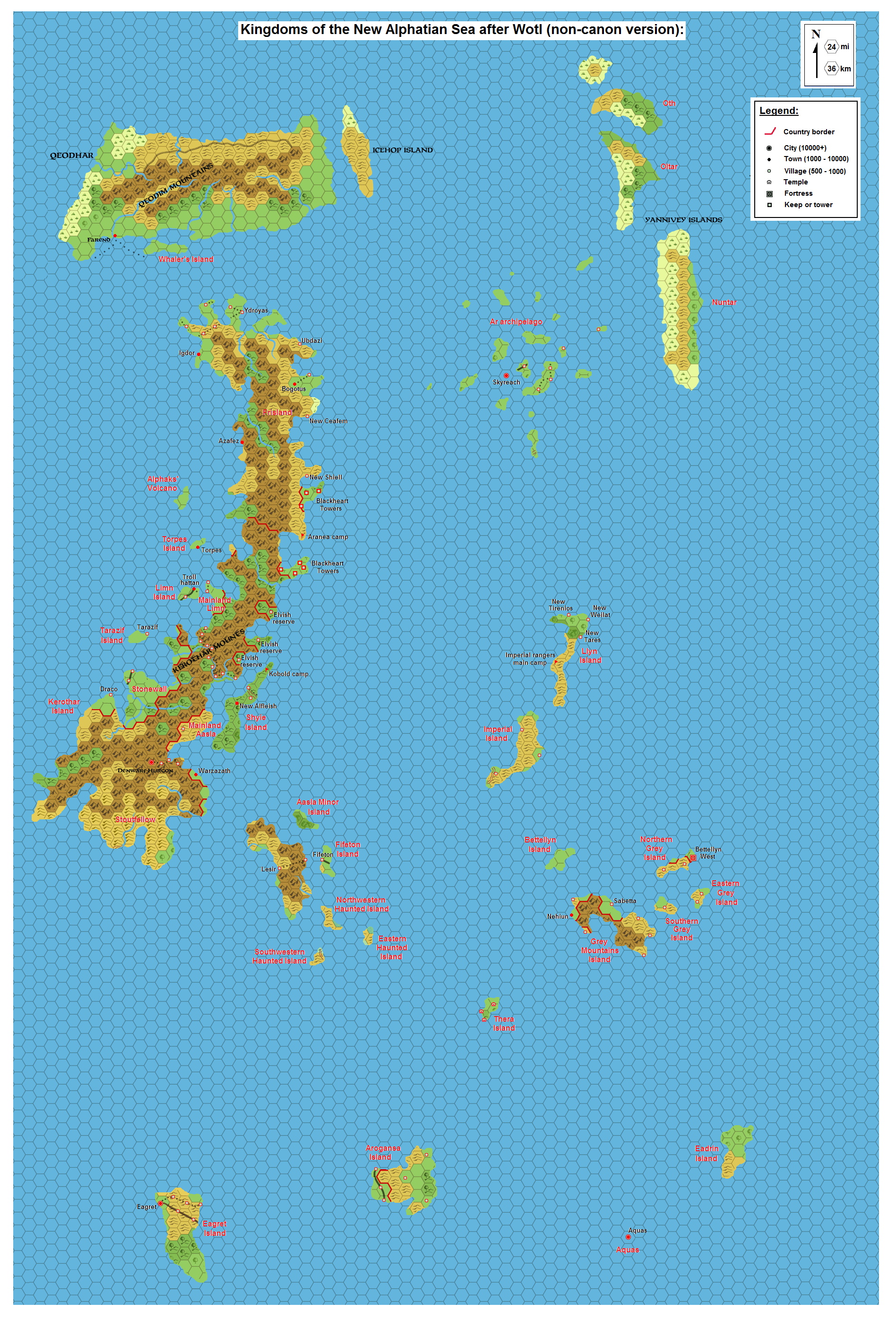
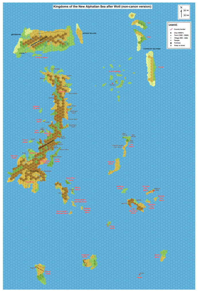
LoZompatore’s New Alphatian Sea, 24 miles per hex
This was the second map of Michele’s project about post-sinking Alphatia, following up on the first, Alphatia, 24 miles per hex Tidal Wave. While the first dealt with the moment of sinking and the immense tidal wave enveloping the land, this second map adapted official post-sinking maps to incorporate the idea of evacuation and survivors.
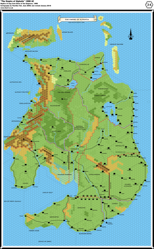
Although Michele labelled his map (and his project) as unofficial, it could be argued that he didn’t actually contradict the official descriptions. All of the post-sinking maps were small scale — 72 miles per hex at best — and there wasn’t a great deal of detail as to the precise makeup of the remnants of Alphatia. Michele’s map, on the other hand, was larger scale than all of those, being based on the original Dawn of the Emperors Alphatia, 24 miles per hex map.
Regardless, this was a thoughtful and well-reasoned attempt at providing more detail to the catastrophe of Alphatia’s sinking and its aftermath.
Fan-made Map by Michele Carpita (October 2010)
This is an original map created by one of Mystara’s excellent fan cartographers. For more information on the cartographer, including a gallery of all their maps, see also Appendix M: Mappers of Mystara.
Sources
- Dawn of the Emperors (1989) (PDF at DriveThruRPG)
- Wrath of the Immortals (1992) (PDF at DriveThruRPG)
- Poor Wizard’s Almanac (1992) (PDF at DriveThruRPG)
Fan Sources
- Settlements of the New Alphatian Sea (a what-if scenario) discussion thread at The Piazza (October 2010)
References
- All of Michele’s maps at the Atlas of Mystara
- Michele’s entry in Appendix M: Mappers of Mystara (upcoming)
- Michele’s author page at the Vaults of Pandius
Chronological Analysis
This is a fan-made map. It was published in October 2010. The updated Atlas version of this map is not yet available. See also Appendix C for annual chronological snapshots of the area. For the full context of this map in Mystara’s publication history, see the upcoming Let’s Map Mystara 2010.
The following lists are from the Let’s Map Mystara project. Additions are new features, introduced in this map. Revisions are changes to previously-introduced features. Hex Art & Fonts track design elements. Finally, Textual Additions are potential features found in the related text. In most cases, the Atlas adopts these textual additions into updated and chronological maps.
Under Construction! Please check back again soon for updates.
Additions
- XXX —
Revisions
- XXX —
Hex Art & Fonts
- Hex Art —
- Fonts —
")
")
")